
Map of Kazakhstan
Kazakhstan is a country in Asia with its capital at Astana, home to about 20.84 million people across 2.72M km². The interactive map below plots 96 cities and towns, 8 rivers, 34 lakes and 3 mountain summits recorded for Kazakhstan in YearMaps.
- Population
- 20.84 million
- Area
- 2.72M km²
- Capital
- Astana
- Continent
- Asia
Interactive Map of Kazakhstan
Centred on Astana at 51.1811° N, 71.4278° E. Use the layer panel to switch on rivers, dams, ports, peaks and historical borders.
About Kazakhstan
Kazakhstan, officially the Republic of Kazakhstan, is a landlocked country situated primarily in Central Asia, with a portion of its territory extending into Eastern Europe. It borders Russia to the north and west, China to the east, Kyrgyzstan to the southeast, Uzbekistan to the south, and Turkmenistan to the southwest, and it has a coastline along the Caspian Sea. The capital is Astana, and the country's largest city and principal cultural and economic center is Almaty, which served as the capital until 1997.
Kazakhstan is the world's ninth-largest country by land area and the largest landlocked country. Hilly plateaus and plains account for nearly half its vast territory, with lowlands composing another third; its southern and eastern frontiers are composed of mountainous regions. Kazakhstan has a population of 20.6 million and one of the lowest population densities in the world, with fewer than 8 people per square kilometre (21 people/mi2). Ethnic Kazakhs constitute a majority, while ethnic Russians form a significant minority. Officially secular, Kazakhstan is a Muslim-majority country with a sizeable Christian community.
Kazakhstan has been inhabited since the Paleolithic era. In antiquity, various nomadic Iranian peoples such as the Saka, Massagetae, and Scythians. Turkic nomads entered the region from the sixth century. In the 13th century, the area was subjugated by the Mongol Empire under Genghis Khan. Following the disintegration of the Golden Horde in the 15th century, the Kazakh Khanate was established over an area roughly corresponding with modern Kazakhstan. By the 18th century, the Kazakh Khanate had fragmented into three jüz (tribal divisions), which were gradually absorbed and conquered by the Russian Empire; by the mid-19th century, all of Kazakhstan was nominally under Russian rule. Following the 1917 Russian Revolution and subsequent Russian Civil War, it became an autonomous republic of the Russian SFSR within the Soviet Union. Its status was elevated to that of a union republic in 1936. The Soviet government settled Russians and other ethnicities in the republic, which resulted in ethnic Kazakhs being a minority during the Soviet era. Kazakhstan was the last constituent republic of the Soviet Union to declare independence in 1991 during its dissolution.
Kazakhstan dominates Central Asia both economically and politically, accounting for 60% of the region's GDP, primarily through its oil and gas industry; it also has vast mineral resources, ranking among the highest producers of iron and silver in the world.
Summary adapted from Wikipedia: Kazakhstan (CC BY-SA 4.0).

Geography and Climate of Kazakhstan
Ethnic Kazakhs derive from a mix of Turkic nomadic tribes that migrated to the region in the 15th century. The Russian Empire conquered the Kazakh steppe in the 18th and 19th centuries, and Kazakhstan became a Soviet Republic in 1925. Forced agricultural collectivization led to repression and starvation, resulting in more than a million deaths in the early 1930s. During the 1950s and 1960s, the agricultural "Virgin Lands" program generated an influx of settlers -- mostly ethnic Russians, but also other nationalities -- and by the time of Kazakhstan’s independence in 1991, ethnic Kazakhs were a minority. However, non-Muslim ethnic minorities departed Kazakhstan in large numbers from the mid-1990s through the mid-2000s, and a national program has repatriated about a million ethnic Kazakhs (from Uzbekistan, Tajikistan, Mongolia, and the Xinjiang region of China) to Kazakhstan. As a result of this shift, the ethnic Kazakh share of the population now exceeds two-thirds. Kazakhstan's economy is the largest in Central Asia, mainly due to the country's vast natural resources. Current issues include diversifying the economy, attracting foreign direct investment, enhancing Kazakhstan's economic competitiveness, and strengthening economic relations with neighboring states and foreign powers.
- Location
- Central Asia, northwest of China; a small portion west of the Ural (Oral) River in easternmost Europe.
- Climate
- Continental, cold winters and hot summers, arid and semiarid.
- Terrain
- Vast flat steppe extending from the Volga in the west to the Altai Mountains in the east and from the plains of western Siberia in the north to oases and deserts of Central Asia in the south.
- Highest point
- Pik Khan-Tengri 7,010 m note - the northern most 7,000 meter peak in the World.
- Lowest point
- Qauyndy Oyysy -132 m.
- Coastline
- 0 km (landlocked)
- Land borders
- Total: 13,364 km; border countries: China 1,765 km; Kyrgyzstan 1,212 km; Russia 7,644 km; Turkmenistan 413 km; Uzbekistan 2,330 km.
- Major rivers
- Syr Darya river mouth (shared with Kyrgyzstan [s], Uzbekistan, and Tajikistan) - 3,078 km note: [s] after country name indicates river source; [m] after country name indicates river mouth.
- Major lakes
- Fresh water lake(s): Ozero Balkhash - 22,000 sq km; Ozero Zaysan - 1,800 sq km; salt water lake(s): Caspian Sea (shared with Iran, Azerbaijan, Turkmenistan, and Russia) - 374,000 sq km; Aral Sea (north) - 3,300 sq km; Ozero Alakol - 2,650 sq km; Ozero Teniz 1,590 sq km; Ozero Seletytenzi - 780 sq km; Ozero Sasykkol - 740 sq km.
- Natural resources
- Major deposits of petroleum, natural gas, coal, iron ore, manganese, chrome ore, nickel, cobalt, copper, molybdenum, lead, zinc, bauxite, gold, uranium.
- Land use
- Agricultural land: 79.4% (2023 est.); arable land: 11% (2023 est.); permanent crops: 0% (2023 est.); permanent pasture: 68.3% (2023 est.); forest: 1.3% (2023 est.); other: 19.3% (2023 est.)
- Natural hazards
- Earthquakes in the south; mudslides around Almaty.
- Geographic note
- World's largest landlocked country and one of only two landlocked countries in the world that extends into two continents (the other is Azerbaijan); Russia leases approximately 6,000 sq km (2,317 sq mi) of territory enclosing the Baikonur Cosmodrome.
- Languages
- Kazakh (official, Qazaq) 80.1%, Russian 83.7%, English 35.1% (2021 est.)
- Religions
- Muslim 69.3%, Christian 17.2% (Orthodox 17%, other 0.2%), Buddhism 0.1%, other 0.1%, non-believers 2.3%, unspecified 11% (2021 est.)
- Ethnic groups
- Kazakh 71%, Russian 14.9%, Uzbek 3.3%, Ukrainian 1.9%, Uyghurs 1.5%, German 1.1%, Tatar 1.1%, other 4.9%, unspecified 0.3% (2023 est.)
- Economy
- Upper-middle-income Central Asian economy; robust growth due to rising oil production, expansion in manufacturing and services, rising domestic demand, and infrastructure investments; however, rapid growth contributing to high inflation rate; declining unemployment and poverty rates.
From the CIA World Factbook (public domain), archived edition of 2026-01-22. The Factbook is no longer updated, so figures reflect that edition.
Kazakhstan in Numbers
- Population
- 20.84 million
- GDP
- US$306.2 billion
- GDP per person
- US$14,692
- Life expectancy
- 74.5 years
- Population growth
- 1.21% a year
- Population density
- 8 per km²
- Urban population
- 62.4%
- Surface area
- 2,724,902 km²
- Forest cover
- 1.3%
- Arable land
- 11.3%
- Access to electricity
- 100.0%
- Internet users
- 93.4%
Indicators from World Bank Open Data (CC BY 4.0). The year under each figure is its reference year.
Kazakhstan in Depth
History
Kazakhstan has been inhabited since the Paleolithic era. The Botai culture (3700–3100 BC) is credited with the first domestication of horses. The Botai population derived most of their ancestry from a deeply European-related population known as Ancient North Eurasians, while also displaying some Ancient East Asian admixture. Pastoralism developed during the Neolithic. The population was Caucasoid during the Bronze and Iron Age period.
The Kazakh territory was a key constituent of the Eurasian trading Steppe Route, the ancestor of the terrestrial Silk Roads. Archaeologists believe that humans first domesticated the horse in the region's vast steppes.
Geography
Since it extends across both sides of the Ural River, considered the dividing line separating Europe and Asia, Kazakhstan is one of only two landlocked countries in the world that has territory in two continents (the other is Azerbaijan).
With an area of 2,700,000 square kilometres (1,000,000 sq mi)—equivalent in size to Western Europe—Kazakhstan is the ninth-largest country and largest landlocked country in the world. While it was part of the Russian Empire, Kazakhstan lost some of its territory to China's Xinjiang province, and some to Uzbekistan's Karakalpakstan autonomous republic during Soviet years.
Economy
In 2018, Kazakhstan had a GDP of $179.332 billion and an annual growth rate of 4.5%. Per capita, Kazakhstan's GDP stood at $9,686. Buoyed by high world crude oil prices, GDP growth figures were between 8.9% and 13.5% from 2000 to 2007 before decreasing to 1% to 3% during the 2008 financial crisis, and then rising again from 2010. Other major exports of Kazakhstan include wheat, textiles, and livestock. Kazakhstan is a leading exporter of uranium.
Kazakhstan's economy grew by 4.6% in 2014. The country experienced a slowdown in economic growth from 2014 sparked by a falling price of oil and the effects of the Russo-Ukrainian War. The country devalued its currency by 19% in February 2014. Another 22% devaluation occurred in August 2015.
Demographics
Kazakhstan had an estimated population of 20.8 million as of 2025. According to official statistics, the country's population surpassed 20 million in September 2024, compared to 17,280,000 a decade earlier. This reflects significant growth since independence in 1991, when the population was 16.4 million, before subsequently declining to 14.8 million by 2001, due mostly to emigration by ethnic Russians.
In contrast to most post-Soviet states, Kazakhstan has maintained replacement rate fertility since independence, with a total fertility rate of 2.53 in 2025. Consequently, the country has a young population, with 29% of Kazakhstanis being 14 years old and younger, and only 9% aged 65 and older.
Sections adapted from Wikipedia: Kazakhstan (CC BY-SA 4.0).
Kazakhstan: Key Facts
| Currency | Kazakhstani tenge |
|---|---|
| Official languages | Kazakh, Russian |
| Head of state | Kassym-Jomart Tokayev |
| Head of government | Olzhas Bektenov |
| Form of government | presidential system |
| Calling code | +7 |
| Internet domain | .kz |
| Highest point | Khan Tengri |
| Lowest point | Karagiye |
| Established | 1991 |
Facts from Wikidata Q232 (CC0).
History of Kazakhstan: Empires and States
The atlas records 55 polities whose mapped territory included part of Kazakhstan, from Scythia in 650 BCE to 2024 CE. They are listed in the order they first appear.
| Polity | Period here | Extent |
|---|---|---|
| Scythia | 650–551 BCE | A small part |
| Yuezhi | 404–111 BCE | A small part |
| Wusun | 170 BCE – 90 CE | A small part |
| Xiongnu | 170 BCE – 153 CE | A small part |
| Xianbei | 106–223 CE | A small part |
| Huns | 106–425 CE | A small part |
| Xionites | 387–401 CE | A small part |
| Kidarites | 402–442 CE | A small part |
| Rouran Khaganate | 402–554 CE | A small part |
| White Huns | 410–560 CE | A small part |
| Hunnic Empire | 426–468 CE | A small part |
| Göktürk Khaganate | 555–586 CE | Most |
| Western Göktürks | 587–660 CE | Most |
| Khazaria | 647–969 CE | A small part |
| The Tang Dynasty | 656–756 CE | A large part |
| Turks | 666–754 CE | A small part |
| Türgesh | 705–749 CE | A small part |
| Uyghur Khaganate | 750–792 CE | A small part |
| Oghuz Turks | 750–1055 CE | A small part |
| Kimek-Kipchak confederation | 750–1235 CE | A large part |
| The Abbasid Caliphate | 755–885 CE | A small part |
| Qarlugs | 793–849 CE | A small part |
| Kara-Khanids | 850–1045 CE | A small part |
| Samanid Empire | 886–999 CE | A small part |
| Seljuk Dynasty | 990–1039 CE | A small part |
| Great Seljuk Empire | 1040–1146 CE | A small part |
| Western Karakhanid Khanate | 1046–1084 CE | A small part |
| Eastern Kara-Khanids | 1046–1138 CE | A small part |
| Khwarezmid Dynasty | 1094–1146 CE | A small part |
| Kara-Khitans | 1139–1219 CE | A large part |
| Khwarezmid Empire | 1210–1219 CE | A small part |
| The Mongol Empire | 1220–1368 CE | Nearly all |
| Golden Horde | 1294–1449 CE | Most |
| Chagatai Khanate | 1294–1462 CE | A small part |
| White Horde | 1363–1384 CE | Most |
| Blue Horde | 1363–1401 CE | A small part |
| Vassalage of Kingdom of Georgia to Timurid Empire | 1395–1406 CE | A small part |
| Timurid Empire | 1395–1515 CE | A small part |
| Vassalage of Qara Qoyunlu to Timurid Empire | 1407–1467 CE | A small part |
| Khanate of Sibir | 1429–1587 CE | A large part |
| Nogai Horde | 1450–1563 CE | A small part |
| Moghulistan | 1463–1518 CE | A small part |
| Kazakh Khanate | 1468–1847 CE | Most |
| Eastern Chagatai Khanate | 1492–1511 CE | A small part |
| Shaybanids | 1497–1511 CE | A small part |
Also recorded: Small Horde, Tsardom of Russia, Oirat Confederation, Dzungar Khanate, The Russian Empire, The Qing Dynasty, Khanate of Khiva, Khanate of Kokand, Union of Soviet Socialist Republics, Kazakhstan.
Historical Maps of Kazakhstan
Kazakhstan on the world map in each year one of these states held it:
Derived by testing mapped cities against dated territorial polygons. Dates are when the polygons cover this place, not the polity's whole lifespan, and polities absent from the source dataset are not listed.
Visiting Kazakhstan
Kazakhstan (Kazakh: Қазақстан Qazaqstan; Russian: Казахстан) is the largest of the states of the former Soviet Union apart from Russia, and it dwarfs the other countries of Central Asia and stretches into Eastern Europe. Kazakhstan is the richest country in the region due to its large oil and natural gas reserves and is also the largest in Central Asia. And while the endless, featureless steppe might repel some visitors the emptiness and mystery of this goliath state keeps many others captivated.
Travel notes adapted from Wikivoyage: Kazakhstan (CC BY-SA 4.0).
Largest Cities in Kazakhstan
96 cities recorded. Ranked by metropolitan population. A port city's harbour is written up on the page of its sea.
| # | Name | Population | Region | Role |
|---|---|---|---|---|
| 1 | Almaty | 1.21 million | Almaty | Admin-1 capital |
| 2 | Shymkent | 465,392 | South Kazakhstan | Admin-1 capital |
| 3 | Qaraghandy | 451,800 | Qaraghandy | Populated place |
| 4 | Taraz | 358,153 | Zhambyl | Admin-1 capital |
| 5 | Astana | 345,604 | Aqmola | National capital |
| 6 | Pavlodar | 329,002 | Pavlodar | Admin-1 capital |
| 7 | Oskemen | 319,067 | East Kazakhstan | Admin-1 capital |
| 8 | Semey | 311,353 | East Kazakhstan | Admin-1 capital |
| 9 | Qyzylorda | 300,000 | Qyzylorda | Admin-1 capital |
| 10 | Aqtobe | 262,457 | Aqtöbe | Admin-1 capital |
| 11 | Oostanay | 236,901 | Qostanay | Admin-1 capital |
| 12 | Petropavlovsk | 228,238 | North Kazakhstan | Admin-1 capital |
| 13 | Oral | 209,788 | West Kazakhstan | Admin-1 capital |
| 14 | Atyrau | 182,753 | Atyrau | Admin-1 capital |
| 15 | Temirtau | 170,600 | Qaraghandy | Populated place |
| 16 | Mangyshlak | 147,443 | Mangghystau | Admin-1 capital |
| 17 | Kokshetau | 128,873 | Aqmola | Admin-1 capital |
| 18 | Ekibastuz | 127,868 | Pavlodar | Populated place |
| 19 | Rudny | 124,000 | Qostanay | Populated place |
| 20 | Zhezqazghan | 104,357 | Qaraghandy | Admin-1 capital |
| 21 | Turkistan | 97,360 | South Kazakhstan | Populated place |
| 22 | Taldyqorghan | 88,380 | Almaty | Admin-1 capital |
| 23 | Balqash | 81,364 | Qaraghandy | Populated place |
| 24 | Sarqan | 76,919 | Almaty | Populated place |
| 25 | Kentau | 57,408 | South Kazakhstan | Populated place |
The other 71 (population, region, role)
- Ridder · 56,756 · East Kazakhstan · Populated place
- Arqalyq · 55,521 · Qostanay · Populated place
- Zyryanovsk · 49,658 · East Kazakhstan · Populated place
- Zhetiqara · 46,740 · Qostanay · Populated place
- Ayakoz · 45,861 · East Kazakhstan · Populated place
- Arys · 42,648 · South Kazakhstan · Populated place
- Shu · 42,439 · Zhambyl · Populated place
- Qapshaghay · 42,167 · Almaty · Populated place
- Qaratau · 37,881 · Zhambyl · Populated place
- Qulsary · 37,103 · Atyrau · Populated place
- Zharkent · 36,496 · Almaty · Populated place
- Baykonur · 36,175 · Qyzylorda · Populated place
- Atbasar · 35,819 · Aqmola · Populated place
- Esik · 35,319 · Almaty · Populated place
- Aqsay · 34,799 · West Kazakhstan · Populated place
- Aral · 33,017 · Qyzylorda · Populated place
- Beyneu · 32,452 · Mangghystau · Populated place
- Balyqshy · 31,624 · Atyrau · Populated place
- Shieli · 29,832 · Qyzylorda · Populated place
- Algha · 28,267 · Aqt · Populated place
- Oktyabrsk · 28,196 · Aqtöbe · Populated place
- Shalqar · 27,256 · Aqt · Populated place
- Shemonaikha · 27,176 · East Kazakhstan · Populated place
- Erymentau · 25,141 · Aqmola · Populated place
- Khromtau · 23,715 · Aqtöbe · Populated place
- Lenger · 23,058 · South Kazakhstan · Populated place
- Makinsk · 23,020 · Aqmola · Populated place
- Oytal · 22,673 · Zhambyl · Populated place
- Qarazhal · 22,170 · Qaraghandy · Populated place
- Boralday · 20,996 · Almaty · Populated place
- Ushtobe · 20,492 · Almaty · Populated place
- Zhosaly · 20,065 · Qyzylorda · Populated place
- Atasu · 19,616 · Qaraghandy · Populated place
- Embi · 18,760 · Aqtöbe · Populated place
- Zaysan · 17,600 · East Kazakhstan · Populated place
- Derzhavinsk · 15,848 · Aqmola · Populated place
- Urzhar · 14,826 · East Kazakhstan · Populated place
- Maqat · 14,082 · Atyrau · Populated place
- Esil · 13,504 · Aqmola · Populated place
- Tayynsha · 13,148 · North Kazakhstan · Populated place
- Qulan · 13,128 · Zhambyl · Populated place
- Otar · 11,238 · Almaty · Populated place
- Bulaevo · 9,886 · North Kazakhstan · Populated place
- Komsomolets · 9,838 · Qostanay · Populated place
- Aqadyr · 9,710 · Qaraghandy · Populated place
- Ertis · 9,216 · Pavlodar · Populated place
- Shar · 9,087 · East Kazakhstan · Populated place
- Kachiry · 8,931 · Pavlodar · Populated place
- Makhambet · 8,905 · Atyrau · Populated place
- Zhangaozen · 8,895 · Mangghystau · Populated place
- Aqsu · 8,543 · Aqmola · Populated place
- Zhanibek · 8,212 · West Kazakhstan · Populated place
- Qarqaraly · 8,195 · Qaraghandy · Populated place
- Qusmuryn · 8,049 · Qostanay · Populated place
- Bayghanin · 7,657 · Aqtöbe · Populated place
- Osakarovka · 7,305 · Qaraghandy · Populated place
- Bestobe · 7,189 · Aqmola · Populated place
- Tobol · 7,155 · Qostanay · Populated place
- Zholymbet · 6,876 · Aqmola · Populated place
- Kishkenekol · 6,779 · North Kazakhstan · Populated place
- Qazaly · 6,582 · Qyzylorda · Populated place
- Chapaev · 6,000 · West Kazakhstan · Populated place
- Turgay · 5,277 · Qostanay · Admin-1 capital
- Fort Shevchenko · 5,213 · Mangghystau · Populated place
- Aqtau · 4,479 · Mangghystau · Populated place
- Saryshaghan · 4,365 · Qaraghandy · Populated place
- Shonzhy · 3,902 · Almaty · Populated place
- Serebryansk · 701 · East Kazakhstan · Populated place
- Zhaltyr · 694 · Aqmola · Populated place
- Sharbaqty · 107 · Pavlodar · Populated place
- Burylbaytal · 100 · Zhambyl · Populated place
Highest Mountains in Kazakhstan
3 mountains recorded. Ranked by summit elevation above sea level. A summit on a border is listed under both countries.
| # | Name | Elevation | Feet | Region |
|---|---|---|---|---|
| 1 | Pik Talghar | 4,979 m | 16,335 ft | Asia |
| 2 | Belukha | 4,506 m | 14,783 ft | Asia |
| 3 | Gora Tastau | 2,992 m | 9,816 ft | Asia |
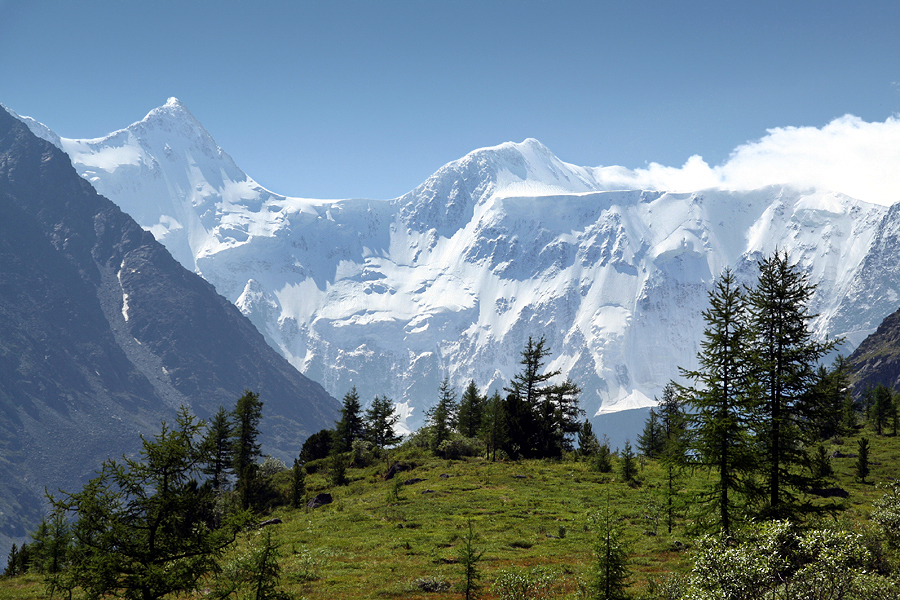
Belukha
Mountain · 4,506 m
Belukha is a mountain rising to 4,506 metres (14,783 ft) in Russia and Kazakhstan, in the Asia region. The summit stands on the border between them.
Belukha Mountain (; Russian: Белуха, IPA: [bʲɪˈɫuxə]) or Üç-Sümer (Altay: Ӱч-Сӱмер [ʏc͡ç sʏˈmer], which translates as "the three peaks") is the highest mountain of the Altai Mountains and the highest of the South Siberian Mountains system. It is part of the Golden Mountains of Altai World Heritage Site.
Adapted from Wikipedia: Belukha Mountain (CC BY-SA 4.0).
- Elevation
- 4,506 m (14,783 ft)
- Global rank
- #80 of 641 indexed
- Region
- Asia (#45)
- Countries
- Russia, Kazakhstan
- Coordinates
- 49.8071°, 86.6063°
Of the 641 named summits indexed in YearMaps, Belukha ranks #80 by elevation, below Mount Wilhelm (4,509 m) and above Laotzyunshan (4,500 m).
- Ranges:
- Altay Mountains (Asia), Tannu-Ola Range (Asia)
- Settlements below:
- Zyryanovsk (169 km), Ridder (229 km), Oskemen (287 km)
More about Belukha
Geography
Belukha is a multi-peaked massif that rises along the border of Russia (specifically the Altai Republic) and Kazakhstan (specifically the East Kazakhstan Region), just a few dozen miles north of the China-Kazakhstan-Russia tripoint. There are several small glaciers on the massif, including Belukha Glacier. The highest peaks of the Belukha massif range from about 4,350 meters to just over 4,500 meters in elevation.
History
Belukha was first climbed in 1914 by the Tronov brothers. Most ascents of the eastern peak follow the same southern route as that taken in the first ascent. Though the Altai is lower in elevation than other Asian mountain groups, it is very remote, and much time and planning are required for its approach.
In the summer of 2001, a team of scientists traveled to the remote Belukha Glacier to assess the feasibility of extracting ice cores at the site. Research was carried out from 2001 to 2003: both shallow cores and cores to bedrock were extracted and analyzed (Olivier and others, 2003; Fujita and others, 2004). Based on tritium dating techniques, the deeper cores may contain as much as 3,000–5,000 years of climatic and environmental records. A Swiss-Russian team also studied the glacier.
Sections adapted from Wikipedia: Belukha Mountain (CC BY-SA 4.0).
Belukha: Key Facts
| Topographic prominence | 3,343 m |
|---|---|
| Mountain range | Katun Range |
Facts from Wikidata Q724367 (CC0).
Largest Lakes in Kazakhstan
34 lakes recorded. Ranked by mapped surface area. A lake on a border is listed under each country it lies in, with the area of the whole lake.
| # | Name | Surface Area | Type |
|---|---|---|---|
| 1 | Caspian Sea | 425,231 km² | Inland Sea / Endorheic Lake |
| 2 | Aral Sea | 18,580 km² | Alkaline Lake |
| 3 | Lake Balkhash | 17,551 km² | Lake |
| 4 | Lake Zaysan | 4,195 km² | Reservoir |
| 5 | Alakol | 2,834 km² | Alkaline Lake |
| 6 | Tengiz Köli | 1,424 km² | Alkaline Lake |
| 7 | Kapchagay Reservoir | 933 km² | Reservoir |
| 8 | Sasyqkl | 750 km² | Lake |
| 9 | Siletitengiz Kli | 647 km² | Lake |
| 10 | Shardara Bgeni | 586 km² | Reservoir |
Rivers in Kazakhstan
8 rivers recorded. Listed alphabetically. A river is listed where its mapped reach lies, so long rivers appear under more than one country.
UNESCO World Heritage Sites in Kazakhstan
2 World Heritage Sites recorded. Listed by year of inscription, earliest first. Sites shared with another country appear under each.
| # | Name | Inscribed | Type | Criteria |
|---|---|---|---|---|
| 1 | Mausoleum of Khoja Ahmed Yasawi | 2003 | Cultural | (i) (iii) (iv) |
| 2 | Tamgaly | 2004 | Cultural | (iii) |
Mountain Ranges, Deserts and Landforms of Kazakhstan
16 mountain ranges, deserts and other landforms recorded. Ranked by mapped area. Covers mountain ranges, deserts, plateaus, named glaciers, plains, basins, peninsulas and capes. One that crosses a border is listed under every country it lies in, with the area of the whole feature.
| # | Name | Area | Type | Region |
|---|---|---|---|---|
| 1 | Asia | 46.28M km² | Continent | Asia |
| 2 | Europe | 11.24M km² | Continent | Europe |
| 3 | Turan Lowland | 873,039 km² | Plain | Asia |
| 4 | Tian Shan | 414,352 km² | Range/mtn | Asia |
| 5 | Altay Mountains | 404,274 km² | Range/mtn | Asia |
| 6 | Kazakh Steppe | 272,208 km² | Plain | Asia |
| 7 | Betpaqdala Desert | 133,535 km² | Desert | Asia |
| 8 | Pontic Steppe | 102,190 km² | Plain | Europe |
| 9 | Ustyurt Plateau | 76,986 km² | Plateau | Asia |
| 10 | Alataw Mountains | 64,390 km² | Range/mtn | Asia |
States and Provinces of Kazakhstan
14 first-level divisions with their own map.
- Almaty map10 cities
- Aqmola map11 cities
- Aqtöbe map5 cities
- Atyrau map5 cities
- East Kazakhstan map10 cities
- Mangghystau map5 cities
- North Kazakhstan map4 cities
- Pavlodar map5 cities
- Qaraghandy map10 cities
- Qostanay map8 cities
- Qyzylorda map6 cities
- South Kazakhstan map5 cities
- West Kazakhstan map4 cities
- Zhambyl map6 cities
Countries Bordering Kazakhstan
Land and maritime neighbours.
More Maps in Asia
Kazakhstan: Quick Answers
- What is the capital of Kazakhstan?
- The capital of Kazakhstan is Astana.
- What is the population of Kazakhstan?
- Kazakhstan has a population of about 20.84 million, the #65 largest of 225 countries in YearMaps. Source: World Bank, 2025.
- How big is Kazakhstan?
- Kazakhstan covers 2.72M km², ranking #10 by area, with about 8 people per square kilometre.
- Which continent is Kazakhstan in?
- Kazakhstan is in Asia.
- Which countries border Kazakhstan?
- Kazakhstan shares a land or maritime border with China, Russia, Uzbekistan, Kyrgyzstan, Turkmenistan.
- What is the largest city in Kazakhstan?
- Almaty is the largest city in Kazakhstan, with a metropolitan population of about 1.21 million.
- What is the highest mountain in Kazakhstan?
- The highest summit recorded for Kazakhstan in YearMaps is Pik Talghar at 4,979 m (16,335 ft). Summits on a border are counted for both countries.
- What is the largest lake in Kazakhstan?
- The largest lake recorded in or bordering Kazakhstan is Caspian Sea, at roughly 425,231 km².