
Map of Philippines
Philippines is a country in Asia with its capital at Manila, home to about 116.79 million people across 343,448 km². The interactive map below plots 38 cities and towns, 1 rivers, 2 lakes, 7 mountain summits and 59 ports recorded for Philippines in YearMaps.
- Population
- 116.79 million
- Area
- 343,448 km²
- Capital
- Manila
- Continent
- Asia
Interactive Map of Philippines
Centred on Manila at 14.6061° N, 120.9803° E. Use the layer panel to switch on rivers, dams, ports, peaks and historical borders.
About Philippines
The Philippines, officially the Republic of the Philippines, is an archipelagic country in Southeast Asia. Located in the western Pacific Ocean, it consists of about 7,641 islands, with a total area of about 300,000 square kilometers. The islands are broadly categorized into three main geographical divisions: from north to south, Luzon, Visayas, and Mindanao. With a population of over 114 million, it is the world's thirteenth-most-populous country.
The Philippines is bounded by the South China Sea to the west, the Philippine Sea to the east, and the Celebes Sea to the south. It shares maritime borders with Taiwan to the north, Japan to the northeast, Palau to southeast, Indonesia to the south, Malaysia to the southwest, Vietnam to the west, and China to the northwest. It has diverse ethnicities and a rich culture. Manila is the country's capital, and its most populated city is Quezon City. Both are within Metro Manila.
Negritos, the archipelago's earliest inhabitants, were followed by waves of Austronesian peoples. The adoption of animism, Hinduism with Buddhist influence, and Islam established island-kingdoms. Extensive overseas trade with neighbors such as the late Tang or Song empire brought Chinese people to the archipelago as well, who would also gradually settle in and intermix over the centuries. The arrival of the explorer Ferdinand Magellan marked the beginning of Spanish colonization. In 1543, Spanish explorer Ruy López de Villalobos named the archipelago las Islas Filipinas in honor of King Philip II. Catholicism became the dominant religion, and Manila became the western hub of trans-Pacific trade. Hispanic immigrants from Latin America and Iberia would also selectively colonize. The Philippine Revolution began in 1896, and became entwined with the 1898 Spanish–American War. Spain ceded the territory to the United States, and Filipino revolutionaries declared the First Philippine Republic. The ensuing Philippine–American War ended with the United States controlling the territory until the Japanese invasion of the islands during World War II. After the United States retook the Philippines from the Japanese, the Philippines became independent in 1946. Since then, the country notably experienced a period of martial law from 1972 to 1981 under the dictatorship of Ferdinand Marcos and his subsequent overthrow by the People Power Revolution in 1986, returning to democracy.
Summary adapted from Wikipedia: Philippines (CC BY-SA 4.0).

Geography and Climate of Philippines
The Philippine Islands became a Spanish colony during the 16th century; they were ceded to the US in 1898 following the Spanish-American War. Led by Emilio AGUINALDO, the Filipinos conducted an insurgency against US rule from 1899-1902, although some fighting continued in outlying islands as late as 1913. In 1935, the Philippines became a self-governing commonwealth. Manuel QUEZON was elected president and was tasked with preparing the country for independence after a 10-year transition. The islands fell under Japanese occupation during World War II, and US forces and Filipinos fought together during 1944-45 to regain control. On 4 July 1946 the Republic of the Philippines attained its independence. Twenty-one years of authoritarian rule under Ferdinand MARCOS ended in 1986, when a "people power" movement in Manila ("EDSA 1") forced him into exile and installed Corazon AQUINO as president. Several coup attempts hampered her presidency, and progress on political stability and economic development faltered until Fidel RAMOS was elected president in 1992. The US closed its last military bases on the islands the same year. Joseph ESTRADA was elected president in 1998. His vice-president, Gloria MACAPAGAL-ARROYO, succeded him in 2001 after ESTRADA's stormy impeachment trial on corruption charges broke down and another "people power" movement ("EDSA 2") demanded his resignation. MACAPAGAL-ARROYO was elected president in 2004. Corruption allegations marred her presidency, but the Philippine economy was one of the few to avoid contraction after the 2008 global financial crisis. Benigno AQUINO III was elected as president in 2010, followed by Rodrigo DUTERTE in 2016. During his term, DUTERTE pursued a controversial drug war that garnered international criticism for alleged human rights abuses. Ferdinand MARCOS, Jr. was elected president in 2022 with the largest popular vote in a presidential election since his father's ouster. For decades, the country has been challenged by armed ethnic separatists, communist rebels, and Islamic terrorist groups, particularly in the southern islands and remote areas of Luzon.
- Location
- Southeastern Asia, archipelago between the Philippine Sea and the South China Sea, east of Vietnam.
- Climate
- Tropical marine; northeast monsoon (November to April); southwest monsoon (May to October)
- Terrain
- Mostly mountains with narrow to extensive coastal lowlands.
- Highest point
- Mount Apo 2,954 m.
- Lowest point
- Philippine Sea 0 m.
- Coastline
- 36,289 km.
- Land borders
- Total: 0 km.
- Major lakes
- Salt water lake(s): Laguna de Bay - 890 sq km.
- Natural resources
- Timber, petroleum, nickel, cobalt, silver, gold, salt, copper.
- Land use
- Agricultural land: 42.7% (2023 est.); arable land: 18.7% (2023 est.); permanent crops: 18.9% (2023 est.); permanent pasture: 5% (2023 est.); forest: 24.7% (2023 est.); other: 32.7% (2023 est.)
- Natural hazards
- Astride typhoon belt, usually affected by several cyclonic storms each year; landslides; active volcanoes; destructive earthquakes; tsunamis volcanism: significant volcanic activity; Taal (311 m) has been deemed a Decade Volcano by the International Association of Volcanology and Chemistry of the Earth's Interior, worthy of study due to its explosive history and close proximity to human populations; Mayon (2,462 m), the country's most active volcano, erupted in 2009 and forced over 33,000 to be evacuated; other historically active volcanoes include Biliran, Babuyan Claro, Bulusan, Camiguin, Camiguin de Babuyanes, Didicas, Iraya, Jolo, Kanlaon, Makaturing, Musuan, Parker, Pinatubo, and Ragang; see note 2 under "Geography - note".
- Geographic note
- Note 1: for decades, the Philippine archipelago was reported as having 7,107 islands; in 2016, the national mapping authority reported that hundreds of new islands had been discovered and increased the number of islands to 7,641, though not all of the new islands have been verified note 2: the Philippines is one of the countries along the Ring of Fire, which is a belt bordering the Pacific Ocean that contains about 75% of the world's volcanoes and up to 90% of the world's earthquakes note 3: the Philippines sits on the Pacific typhoon belt, and an average of 9 typhoons make landfall on the islands each year, with about 5 being destructive; the country is the most exposed in the world to tropical storms.
- Languages
- Tagalog 39.9%, Bisaya/Binisaya 16%, Hiligaynon/Ilonggo 7.3%, Ilocano 7.1%, Cebuano 6.5%, Bikol/Bicol 3.9%, Waray 2.6%, Kapampangan 2.4%, Maguindanao 1.4%, Pangasinan/Panggalato 1.3%, other languages/dialects 11.2%, unspecified 0.4% (2020 est.)
- Religions
- Roman Catholic 78.8%, Muslim 6.4%, Iglesia ni Cristo 2.6%, other Christian 3.9%, other 8.2%, none/unspecified <0.1 (2020 est.)
- Ethnic groups
- Tagalog 26%, Bisaya/Binisaya 14.3%, Ilocano 8%, Cebuano 8%, Illonggo 7.9%, Bikol/Bicol 6.5%, Waray 3.8%, Kapampangan 3%, Maguindanao 1.9%, Pangasinan 1.9%, other local ethnicities 18.5%, foreign ethnicities 0.2% (2020 est.)
- Economy
- Growing Southeast Asian economy; commercial rebound led by transportation, construction and financial services; electronics exports recovering from sector slowdown; significant remittances; interest rate rises following heightened inflation; uncertainties due to increased regional tensions with China.
From the CIA World Factbook (public domain), archived edition of 2026-01-22. The Factbook is no longer updated, so figures reflect that edition.
Philippines in Numbers
- Population
- 116.79 million
- GDP
- US$487.1 billion
- GDP per person
- US$4,171
- Life expectancy
- 70.0 years
- Population growth
- 0.81% a year
- Population density
- 389 per km²
- Urban population
- 55.8%
- Surface area
- 300,000 km²
- Forest cover
- 24.8%
- Arable land
- 18.8%
- Access to electricity
- 94.8%
- Internet users
- 67.3%
Indicators from World Bank Open Data (CC BY 4.0). The year under each figure is its reference year.
Philippines in Depth
History
There is evidence of early hominins living in what is now the Philippines as early as 709,000 years ago. Bones from Callao Cave potentially represent an otherwise unknown species, Homo luzonensis, who lived 50,000 to 67,000 years ago. The oldest modern human remains on the islands are from the Tabon Caves of Palawan, U/Th-dated to 47,000 ± 11–10,000 years ago. Tabon Man is presumably a Negrito, among the archipelago's earliest inhabitants descended from the first human migrations out of Africa via the coastal route along southern Asia to the now-sunken landmasses of Sundaland and Sahul.
The first Austronesians reached the Philippines from Taiwan around 2200 BC, settling the Batanes Islands (where they built stone fortresses known as ijangs) and northern Luzon.
Geography
The Philippines is an archipelago of approximately 7,641 islands, covering a total area (including inland bodies of water) of about 300,000 square kilometers (115,831 sq mi). Stretching 1,850 kilometers (1,150 mi) north to south, from the South China Sea to the Celebes Sea, the Philippines is bordered by the Philippine Sea to the east, and the Sulu Sea to the southwest. The Luzon Strait is the most economical (quickest) traffic node for shipping between the Americas and Asia.
It is also a critical junction of Asia-Pacific-Americas undersea communication cables. The country's 11 largest islands are Luzon, Mindanao, Samar, Negros, Palawan, Panay, Mindoro, Leyte, Cebu, Bohol and Masbate, about 95 percent of its total land area.
Economy
According to the International Monetary Fund (IMF) in its October 2025 update, the Philippines is the world's 33rd largest economy with a nominal gross domestic product (GDP) of $494.16 billion. As a newly industrialized country, the Philippine economy has been transitioning from an agricultural base to one with more emphasis on services and manufacturing. The country's labor force is about 52.09 million with an unemployment rate of 5.1 percent as of February 2026. Gross international reserves totalled US$106.64 billion as of March 2026. Debt-to-GDP ratio decreased to 60.2 percent at the end of 2023 from a 17-year high 63.7 percent at the end of the third quarter of that year, and indicated resiliency during the COVID-19 pandemic.
Demographics
In July 2024, the Philippines had a population of 112,729,484. More than 60 percent of the country's population live in the coastal zone. In 2020, 54 percent lived in urban areas. Manila, its capital, and Quezon City, the country's most populous city, are in Metro Manila. About 13.48 million people, 12 percent of the Philippines' population, live in Metro Manila, the country's most populous metropolitan area and the world's fifth most populous.
Sections adapted from Wikipedia: Philippines (CC BY-SA 4.0).
Philippines: Key Facts
| Currency | Philippine peso |
|---|---|
| Official languages | Filipino, English, Taglish |
| Head of state | Bongbong Marcos |
| Head of government | Bongbong Marcos |
| Form of government | republic |
| Calling code | +63 |
| Internet domain | .ph |
| Highest point | Mount Apo |
| Lowest point | Philippine Sea |
| Established | 1565 |
Facts from Wikidata Q928 (CC0).
History of Philippines: Empires and States
The atlas records 6 polities whose mapped territory included part of Philippines, from Sultanate of Brunei in 1497 CE to 2024 CE. They are listed in the order they first appear.
| Polity | Period here | Extent |
|---|---|---|
| Sultanate of Brunei | 1497–1581 CE | A large part |
| Sultanate of Maguindanao | 1521–1608 CE | A large part |
| The Spanish Empire | 1572–1899 CE | Most |
| Kingdom of Spain | 1877–1899 CE | Most |
| United States of America | 1898–1946 CE | Most |
| Republic of the Philippines | 1947–2024 CE | Most |
Historical Maps of Philippines
Philippines on the world map in each year one of these states held it:
Derived by testing mapped cities against dated territorial polygons. Dates are when the polygons cover this place, not the polity's whole lifespan, and polities absent from the source dataset are not listed.
Visiting Philippines
The Philippines (Filipino: Pilipinas), officially the Republic of the Philippines (Republika ng Pilipinas), is an archipelago of more than 7,100 islands in Southeast Asia.
The country has one of the world's longest coastlines with many fine beaches and excellent diving. There is great cultural diversity due to the many islands, many waves of immigration, and a mixture of foreign influences — the country has been trading with nearby nations for several thousand years and was a Spanish colony from 1562 to 1898, then American until 1946. It would take decades to visit and experience everything.
Many locals speak English well and a lot of the others have at least some English. Food and accommodations are cheap, many destinations have excellent infrastructure, and the people are cheerful and friendly; perhaps the easiest way to recognize a Filipino abroad is to see who has the broadest smile.
Travel notes adapted from Wikivoyage: Philippines (CC BY-SA 4.0).
Largest Cities in Philippines
38 cities recorded. Ranked by metropolitan population. A port city's harbour is written up on the page of its sea.
| # | Name | Population | Region | Role |
|---|---|---|---|---|
| 1 | Manila | 11.10 million | Metropolitan Manila | National capital |
| 2 | Quezon City | 2.76 million | Metropolitan Manila | Populated place |
| 3 | Davao | 1.40 million | Davao Del Sur | Populated place |
| 4 | Cagayan de Oro | 1.12 million | Misamis Oriental | Populated place |
| 5 | General Santos | 950,530 | South Cotabato | Populated place |
| 6 | Bacolod | 949,354 | Negros Occidental | Populated place |
| 7 | Cebu | 815,000 | Cebu | Populated place |
| 8 | Zamboanga | 773,000 | Zamboanga del Sur | Populated place |
| 9 | Naga | 741,635 | Camarines Sur | Populated place |
| 10 | Iligan | 464,599 | Lanao del Norte | Populated place |
| 11 | Baguio City | 447,824 | Benguet | Admin-0 capital alt |
| 12 | Batangas | 424,508 | Batangas | Populated place |
| 13 | Pasay City | 403,064 | Metropolitan Manila | Populated place |
| 14 | Iloilo | 387,681 | Iloilo | Populated place |
| 15 | Legazpi | 320,081 | Albay | Populated place |
| 16 | Angeles | 314,493 | Pampanga | Populated place |
| 17 | Olongapo | 304,388 | Zambales | Populated place |
| 18 | Cadiz | 283,157 | Negros Occidental | Populated place |
| 19 | Tacloban | 280,006 | Leyte | Populated place |
| 20 | Cotabato | 279,519 | Shariff Kabunsuan | Populated place |
| 21 | San Pablo | 240,830 | Laguna | Populated place |
| 22 | Cabanatuan | 220,250 | Nueva Ecija | Populated place |
| 23 | Laoag | 207,048 | Ilocos Norte | Populated place |
| 24 | Butuan | 190,557 | Agusan del Norte | Populated place |
| 25 | Tarlac | 183,930 | Tarlac | Populated place |
The other 13 (population, region, role)
- Ormac · 167,584 · Leyte · Populated place
- Dagupan · 163,676 · Pangasinan · Populated place
- Pagadian · 159,590 · Zamboanga Del Sur · Populated place
- Puerto Princesa · 157,144 · Palawan · Populated place
- Tuguegarao · 115,105 · Cagayan · Populated place
- Roxas · 102,688 · Capiz · Populated place
- Ozamis · 97,806 · Misamis Occidental · Populated place
- Surigao · 87,832 · Dinagat Islands · Populated place
- Calbayog · 67,921 · Samar · Populated place
- Vigan · 48,545 · Ilocos Sur · Populated place
- Tagum · 6,726 · Davao del Norte · Populated place
- San Carlos · 6,353 · Negros Occidental · Populated place
- Gingoog · 218 · Misamis Oriental · Populated place
Highest Mountains in Philippines
7 mountains recorded. Ranked by summit elevation above sea level. A summit on a border is listed under both countries.
| # | Name | Elevation | Feet | Region |
|---|---|---|---|---|
| 1 | Mount Apo | 2,954 m | 9,692 ft | Asia |
| 2 | Pulog | 2,934 m | 9,626 ft | Asia |
| 3 | Mount Halcon | 2,585 m | 8,481 ft | Asia |
| 4 | Canlaon Pk | 2,430 m | 7,972 ft | Asia |
| 5 | Mount Mantalingajan | 2,085 m | 6,841 ft | Asia |
| 6 | Mount Pinatubo | 1,486 m | 4,875 ft | Asia |
| 7 | Taal Volcano | 400 m | 1,312 ft | Asia |
Largest Lakes in Philippines
2 lakes recorded. Ranked by mapped surface area. A lake on a border is listed under each country it lies in, with the area of the whole lake.
| # | Name | Surface Area | Type |
|---|---|---|---|
| 1 | Laguna de Bay | 912 km² | Lake |
| 2 | Lake Taal | 121 km² | Lake |

Laguna de Bay
Lake · 912 km²
Laguna de Bay is a lake in the Philippines, with a mapped surface area of about 912 km².
Laguna de Bay (Spanish for "Lagoon/Lake of Bay"; Filipino: Lawa ng Bay, [bɐˈʔi]), also known as Laguna Lake and alternatively spelled "Laguna de Bae", is the largest lake in the Philippines. Laguna de Bay remains one of the most important freshwater resources in the Philippines, supporting millions of residents through fisheries, agriculture, and domestic use. It is located southeast of Metro Manila, between the provinces of Laguna to the south and Rizal to the north. The freshwater lake has a surface area of 911–949 km2 (352–366 sq mi), with an average depth of about 2.8 meters (9 ft 2 in) and an elevation of about one meter above sea level. It is shaped like a crow's foot, with two peninsulas jutting out from the northern shore and filling the large volcanic Laguna Caldera. In the middle of the lake is the large island of Talim.
The lake is one of the primary sources of freshwater fish in the country. Its water drains to Manila Bay via the Pasig River. Environmental issues such as water quality problems created by population pressure and industrialization, invasive species, and overfishing are of concern to the lake, hurting its economic importance to the country.
Adapted from Wikipedia: Laguna de Bay (CC BY-SA 4.0).
- Surface area
- 912 km²
- Area rank
- #211 of 756 indexed
- Type
- Lake
- Country
- Philippines
- Coordinates
- 14.3332°, 121.2293°
Among the 756 water bodies with a mapped extent in YearMaps, Laguna de Bay ranks #211 by surface area, after Lake Hammar (929 km²) and ahead of Lake Nipissing (908 km²). Areas are computed from the mapped outline and are approximate.
- Settlements on the shore:
- San Pablo (31 km), Pasay City (35 km), Manila (40 km)
More about Laguna de Bay
Geography
Laguna de Bay is a large shallow freshwater body in the heart of Luzon Island with an aggregate area of about 911 km2 (352 sq mi) and a shoreline of 220 km (140 mi). It is considered to be the third largest inland body of water in Southeast Asia after Tonle Sap in Cambodia and Lake Toba in Sumatra, Indonesia. Laguna de Bay is bordered by the province of Laguna in the east, west and southwest, the province of Rizal in the north to northeast, and Metropolitan Manila in the northwest. The lake has an average depth of 2.8 meters (9 ft 2 in) and its excess water is discharged through the Pasig River.
Sections adapted from Wikipedia: Laguna de Bay (CC BY-SA 4.0).
Laguna de Bay: Key Facts
| Maximum depth | 20 m |
|---|---|
| Volume | 2.25 km³ |
| Surface elevation | 2 m |
| Inflows | Bumbungan River, Molawin River, Sapang Baho River, Manggahan Floodway |
| Outflows | Pasig River |
Facts from Wikidata Q47136 (CC0).
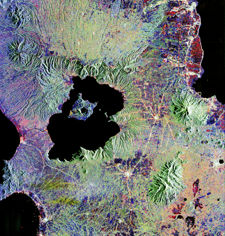
Lake Taal
Lake · 121 km²
Lake Taal is a lake in the Philippines, with a mapped surface area of about 121 km².
Taal Lake (Tagalog: Lawà ng Taál, IPA: [taʔal], older name: Bombón Lake) is a freshwater caldera lake in the province of Batangas, on the island of Luzon in the Philippines. The lake fills Taal Volcano, a large volcanic caldera formed by very large eruptions between 670 and 6 thousand years ago.
It is the country's third-largest lake, after Laguna de Bay and Lake Lanao. Volcano Island, the location of Taal Volcano's historical eruptions and responsible for the lake's sulfur content, lies near the lake's center.
There is a crater lake on Volcano Island. It was known as Yellow Lake and contains its own small islet, Vulcan Point. Vulcan Point is one of the few third-order islands in the world.
Adapted from Wikipedia: Taal Lake (CC BY-SA 4.0).
- Surface area
- 121 km²
- Area rank
- #590 of 756 indexed
- Type
- Lake
- Country
- Philippines
- Coordinates
- 14.0110°, 120.9903°
Among the 756 water bodies with a mapped extent in YearMaps, Lake Taal ranks #590 by surface area, after Bhadra Reservoir (122 km²) and ahead of Franklin D. Roosevelt Lake (119 km²). Areas are computed from the mapped outline and are approximate.
- Settlements on the shore:
- Batangas (26 km), San Pablo (36 km), Pasay City (60 km)
- Other water nearby:
- Laguna de Bay (912 km²), Poyang Hu (2,078 km²)
More about Lake Taal
History
Taal Lake was once an inlet of nearby Balayan Bay, and was easily navigable from it. A series of major eruptions in the early 18th century battered lakeside towns with earthquakes and volcanic debris. This activity culminated in 1754 with Taal Volcano's largest eruption that blocked Pansipit River with tephra, narrowing the lake's sole outlet to the sea. This caused the lake’s waters to rise, eventually submerging several towns along its shore – the remnants of which are reportedly visible underwater to this day. Since the 1754 eruption, the lake’s surface elevation had risen from sea level to 5 metres (16 ft) above sea level, and its saline waters becoming brackish and eventually freshwater after centuries of precipitation.
Ecology
As the lake was previously connected to the sea, it is home to many endemic species that have evolved and adapted to the desalination of the lake's waters. The lake has a freshwater-adapted population of trevally, Caranx ignobilis. This fish, also found in Pansipit River, is locally called maliputo. Its most popular endemic species is the overharvested Sardinella tawilis, a freshwater sardine. The two other endemic fish species in Taal Lake are the gobies Gnatholepis volcanus and Rhinogobius flavoventris.
Taal Lake is also home to one of the world's rarest sea snakes, Hydrophis semperi. This particular species is only one of two "true" sea snake (Hydrophiinae) species that are known to live entirely in freshwater (the other is Hydrophis sibauensis from the Sibua River, Borneo, Indonesia).
Tourism
Regular tours of the lake are available to tourists. After crossing the lake, visitors travel to the top of Volcano Island on horseback. During their trip up and down the mountain, visitors have views of the lake and its surroundings.
Talisay on the northern shore also is the location of the Taal Lake Yacht Club. TLYC has been the host club for sailing events such as the Philippine Hobie Nationals and the Oz Goose Nationals. Taal Lake also has been favored by windsurfers and kiteboarders.
Tagaytay in Cavite has benefited from Taal Lake and Taal Volcano, which is administered by neighboring province of Batangas. Many tourists have visited Tagaytay for a panoramic view of the lake and volcano.
Sections adapted from Wikipedia: Taal Lake (CC BY-SA 4.0).
Lake Taal: Key Facts
| Surface area | 234 km² |
|---|---|
| Maximum depth | 172 m |
| Surface elevation | 5 m |
| Outflows | Pansipit River |
Facts from Wikidata Q537695 (CC0).
Rivers in Philippines
1 river recorded. Listed alphabetically. A river is listed where its mapped reach lies, so long rivers appear under more than one country.
| Name | Type | Also Flows Through |
|---|---|---|
| Cagayan | River | — |
Ports in Philippines
59 ports recorded. Ranked by approach channel depth, the figure that limits which ships can call. Harbours link to their write-up on the page of the sea or coast they lie on.
| # | Name | Channel Depth | Class | Sea | Max Vessel |
|---|---|---|---|---|---|
| 1 | Masao | 56.7 m | Very Small | Philippine, Sulu & Celebes Seas | medium vessels |
| 2 | Sorsogon | 56.7 m | Very Small | Philippine, Sulu & Celebes Seas | point_of_interest |
| 3 | Hinatuan | 56.7 m | Very Small | Philippine, Sulu & Celebes Seas | point_of_interest |
| 4 | Mariveles | 53 m | Very Small | South China Sea & Gulf of Thailand | medium vessels |
| 5 | Aparri | 53 m | Very Small | South China Sea & Gulf of Thailand | medium vessels |
| 6 | Laoang | 53 m | Very Small | Philippine, Sulu & Celebes Seas | point_of_interest |
| 7 | Pulupandan | 53 m | Very Small | Philippine, Sulu & Celebes Seas | medium vessels |
| 8 | General Santos | 49.4 m | Very Small | Philippine, Sulu & Celebes Seas | medium vessels |
| 9 | Port Capiz | 49.4 m | Very Small | Philippine, Sulu & Celebes Seas | medium vessels |
| 10 | Nasipit Port | 45.7 m | Very Small | Philippine, Sulu & Celebes Seas | medium vessels |
The other 49 (channel depth, class, sea, max vessel)
- Tabaco · 45.7 m · Very Small · Philippine, Sulu & Celebes Seas · large vessels
- Tagbilaran · 45.7 m · Small · Philippine, Sulu & Celebes Seas · point_of_interest
- Tubigan · 45.7 m · Very Small · Philippine, Sulu & Celebes Seas · point_of_interest
- Virac · 42.1 m · Very Small · Philippine, Sulu & Celebes Seas · medium vessels
- Mangagoy · 42.1 m · Small · Philippine, Sulu & Celebes Seas · medium vessels
- Port Holland · 42.1 m · Very Small · Philippine, Sulu & Celebes Seas · point_of_interest
- Santa Clara · 38.4 m · Very Small · Philippine, Sulu & Celebes Seas · point_of_interest
- Basilian City (Isabela) · 38.4 m · Very Small · Philippine, Sulu & Celebes Seas · medium vessels
- Siasi · 38.4 m · Very Small · Philippine, Sulu & Celebes Seas · point_of_interest
- Manila · 38.4 m · Major · South China Sea & Gulf of Thailand · medium vessels
- Cebu · 38.4 m · Major · Philippine, Sulu & Celebes Seas · medium vessels
- Port Ozamis · 38.4 m · Very Small · Philippine, Sulu & Celebes Seas · medium vessels
- Basco · 34.7 m · Very Small · South China Sea & Gulf of Thailand · medium vessels
- Tanauan · 34.7 m · Very Small · Philippine, Sulu & Celebes Seas · medium vessels
- Jose Panganiban · 31.1 m · Very Small · Philippine, Sulu & Celebes Seas · medium vessels
- Masinloc · 31.1 m · Very Small · South China Sea & Gulf of Thailand · point_of_interest
- Calapan · 31.1 m · Very Small · Philippine, Sulu & Celebes Seas · point_of_interest
- Catbalogan · 31.1 m · Very Small · Philippine, Sulu & Celebes Seas · point_of_interest
- Maasin · 31.1 m · Very Small · Philippine, Sulu & Celebes Seas · point_of_interest
- Bais · 31.1 m · Very Small · Philippine, Sulu & Celebes Seas · point_of_interest
- Legazpi Port · 31.1 m · Very Small · Philippine, Sulu & Celebes Seas · medium vessels
- San Fernando Harbor · 23.8 m · Minor · South China Sea & Gulf of Thailand · medium vessels
- Toledo · 23.8 m · Small · Philippine, Sulu & Celebes Seas · large vessels
- Port San Vicente · 20.1 m · Very Small · South China Sea & Gulf of Thailand · medium vessels
- Hondagua · 20.1 m · Very Small · Philippine, Sulu & Celebes Seas · large vessels
- Margosatubig · 20.1 m · Very Small · Philippine, Sulu & Celebes Seas · point_of_interest
- Dumaguete · 5.5 m · Very Small · Philippine, Sulu & Celebes Seas · medium vessels
- Claveria · 5.5 m · Very Small · South China Sea & Gulf of Thailand · point_of_interest
- Santa Cruz (Marinduque Isl) · 5.5 m · Very Small · Philippine, Sulu & Celebes Seas · point_of_interest
- Port Romblon · 5.5 m · Very Small · Philippine, Sulu & Celebes Seas · point_of_interest
- Masbate · 5.5 m · Small · Philippine, Sulu & Celebes Seas · medium vessels
- Port Borongan · 5.5 m · Very Small · Philippine, Sulu & Celebes Seas · point_of_interest
- Guiuan · 5.5 m · Very Small · Philippine, Sulu & Celebes Seas · point_of_interest
- Baybay · 5.5 m · Very Small · Philippine, Sulu & Celebes Seas · point_of_interest
- Isabel · 5.5 m · Very Small · Philippine, Sulu & Celebes Seas · medium vessels
- Palompon · 5.5 m · Very Small · Philippine, Sulu & Celebes Seas · point_of_interest
- Lazi · 5.5 m · Very Small · Philippine, Sulu & Celebes Seas · medium vessels
- Mati · 5.5 m · Very Small · Philippine, Sulu & Celebes Seas · large vessels
- Jimenez · 5.5 m · Very Small · Philippine, Sulu & Celebes Seas · large vessels
- Bugo · 5.5 m · Very Small · Philippine, Sulu & Celebes Seas · medium vessels
- Jolo · 5.5 m · Very Small · Philippine, Sulu & Celebes Seas · medium vessels
- Cagayan de Oro · 5.5 m · Minor · Philippine, Sulu & Celebes Seas · medium vessels
- Zamboanga · 5.5 m · Small · Philippine, Sulu & Celebes Seas · medium vessels
- Iligan · 5.5 m · Very Small · Philippine, Sulu & Celebes Seas · medium vessels
- Pagadian · 5.5 m · Very Small · Philippine, Sulu & Celebes Seas · large vessels
- Puerto Princesa · 5.5 m · Small · Philippine, Sulu & Celebes Seas · medium vessels
- Villanueva · Very Small · Philippine, Sulu & Celebes Seas · medium vessels
- Nasugbu · Very Small · Philippine, Sulu & Celebes Seas · medium vessels
- Gingoog · Very Small · Philippine, Sulu & Celebes Seas · medium vessels
UNESCO World Heritage Sites in Philippines
6 World Heritage Sites recorded. Listed by year of inscription, earliest first. Sites shared with another country appear under each.
| # | Name | Inscribed | Type | Criteria |
|---|---|---|---|---|
| 1 | Baroque Churches of the Philippines | 1993 | Cultural | (ii) (iv) |
| 2 | Tubbataha Reef | 1993 | Natural | (vii) (ix) (x) |
| 3 | Rice Terraces of the Philippine Cordilleras | 1995 | Cultural | (iii) (iv) (v) |
| 4 | Puerto Princesa Subterranean River National Park | 1999 | Natural | (vii) (x) |
| 5 | Vigan | 1999 | Cultural | (ii) (iv) |
| 6 | Mount Hamiguitan Range Wildlife Sanctuary | 2014 | Natural | (x) |
Largest Islands of Philippines
14 islands recorded. Ranked by mapped area. An island divided between countries is listed under each, with the area of the whole island.
| # | Name | Area | Type |
|---|---|---|---|
| 1 | Malay Archipelago | 3.91M km² | Island group |
| 2 | Philippines | 377,943 km² | Island group |
| 3 | Luzon | 105,881 km² | Island |
| 4 | Mindanao | 94,557 km² | Island |
| 5 | Negros | 12,943 km² | Island |
| 6 | Samar | 12,619 km² | Island |
| 7 | Panay | 11,628 km² | Island |
| 8 | Palawan | 11,506 km² | Island |
| 9 | Mindoro | 9,916 km² | Island |
| 10 | Sulu Archipelago | 7,934 km² | Island group |
Countries Bordering Philippines
Land and maritime neighbours.
More Maps in Asia
Philippines: Quick Answers
- What is the capital of Philippines?
- The capital of Philippines is Manila.
- What is the population of Philippines?
- Philippines has a population of about 116.79 million, the #14 largest of 225 countries in YearMaps. Source: World Bank, 2025.
- How big is Philippines?
- Philippines covers 343,448 km², ranking #66 by area, with about 340 people per square kilometre.
- Which continent is Philippines in?
- Philippines is in Asia.
- Which countries border Philippines?
- Philippines shares a land or maritime border with Japan, China, Indonesia, Palau, Malaysia, Taiwan.
- What is the largest city in Philippines?
- Manila is the largest city in Philippines, with a metropolitan population of about 11.10 million.
- What is the highest mountain in Philippines?
- The highest summit recorded for Philippines in YearMaps is Mount Apo at 2,954 m (9,692 ft). Summits on a border are counted for both countries.
- What is the largest lake in Philippines?
- The largest lake recorded in or bordering Philippines is Laguna de Bay, at roughly 912 km².