
Map of Timor-Leste
Timor-Leste is a country in Asia with its capital at Dili, home to about 1.42 million people across 14,919 km². The interactive map below plots 1 cities and towns, 1 mountain summits and 1 ports recorded for Timor-Leste in YearMaps.
- Population
- 1.42 million
- Area
- 14,919 km²
- Capital
- Dili
- Continent
- Asia
Interactive Map of Timor-Leste
Centred on Dili at 8.5594° S, 125.5795° E. Use the layer panel to switch on rivers, dams, ports, peaks and historical borders.
About Timor-Leste
Timor-Leste, also known as East Timor, officially the Democratic Republic of Timor-Leste, is a country in Southeast Asia. It comprises the eastern half of the island of Timor, the coastal exclave of Oecusse in the island's northwest, and the islands of Atauro and Jaco, for a total land area of 15,007 square kilometres (5,794 sq mi). Timor-Leste shares a land border with Indonesia to the west; Australia is the country's southern neighbour, across the Timor Sea. Dili, on the north coast of Timor, is its capital and largest city.
Timor was settled over time by various Papuan and Austronesian peoples, which created a diverse mix of cultures and languages linked to Southeast Asia and Melanesia. East Timor came under Portuguese influence in the sixteenth century, remaining a Portuguese colony until 1975. Internal conflict preceded a unilateral declaration of independence and an Indonesian invasion and annexation. The subsequent Indonesian occupation was characterised by extreme abuses of human rights, including torture and massacres, a series of events named the East Timor genocide. Resistance continued throughout Indonesian rule and in 1999, a United Nations–sponsored act of self-determination led Indonesia to relinquish control of the territory. On 20 May 2002, Timor-Leste became the first new sovereign state of the 21st century. That same year, relations with Indonesia were established and normalised, with Indonesia also supporting Timor-Leste's accession into ASEAN.
The national government is a semi-presidential system, with the popularly elected president sharing power with a prime minister appointed by the National Parliament. Power is centralised under the national government, although many local leaders have informal influence. The country maintains a policy of international cooperation and is a member of the Community of Portuguese Language Countries and ASEAN, and is an observer of the Pacific Islands Forum. The country remains relatively poor, with an economy that relies heavily on natural resources, especially oil, and foreign aid.
The total population is over 1.44 million at the 2026 census, and is heavily skewed towards young people because of a high fertility rate. Education has led to increasing literacy over the past half-century, especially in the two official languages of Portuguese and Tetun. High ethnic and linguistic diversity is reflected by the 30 indigenous languages spoken in the country. Most of the population practices Roman Catholicism, which coexists alongside strong local traditions and beliefs, especially in rural areas.
Summary adapted from Wikipedia: Timor-Leste (CC BY-SA 4.0).

Geography and Climate of Timor-Leste
The island of Timor was actively involved in Southeast Asian trading networks for centuries, and by the 14th century, it exported sandalwood, slaves, honey, and wax. The sandalwood trade attracted the Portuguese, who arrived in the early 16th century; by mid-century, they had colonized the island, which was previously ruled by local chieftains. In 1859, Portugal ceded the western portion of the island to the Dutch. Imperial Japan occupied Portuguese Timor from 1942 to 1945, but Portugal resumed colonial authority after the Japanese defeat in World War II. The eastern part of Timor declared itself independent from Portugal on 28 November 1975, but Indonesian forces invaded and occupied the area nine days later. It was incorporated into Indonesia in 1976 as the province of Timor Timur (East Timor or Timor Leste). Indonesia conducted an unsuccessful pacification campaign in the province over the next two decades, during which as many as 250,000 people died. In a UN-supervised referendum in 1999, an overwhelming majority of the people of Timor-Leste voted for independence from Indonesia. However, anti-independence Timorese militias -- organized and supported by the Indonesian military -- began a large-scale, scorched-earth campaign of retribution, killing approximately 1,400 Timorese and displacing nearly 500,000. Most of the country's infrastructure was destroyed, including homes, irrigation systems, water supply systems, schools, and most of the electrical grid. Australian-led peacekeeping troops eventually deployed to the country and ended the violence. In 2002, Timor-Leste was internationally recognized as an independent state. In 2006, Australia and the UN had to step in again to stabilize the country, which allowed presidential and parliamentary elections to be conducted in 2007 in a largely peaceful atmosphere. In 2008, rebels staged an unsuccessful attack against the president and prime minister. Since that attack, Timor-Leste has made considerable progress in building stability and democratic institutions, holding a series of successful parliamentary and presidential elections since 2012. Nonetheless, weak and unstable political coalitions have led to periodic episodes of stalemate and crisis. The UN continues to provide assistance on economic development and strengthening governing institutions. Currently, Timor-Leste is one of the world's poorest nations, with an economy that relies heavily on energy resources in the Timor Sea.
- Location
- Southeastern Asia, northwest of Australia in the Lesser Sunda Islands at the eastern end of the Indonesian archipelago; note - Timor-Leste includes the eastern half of the island of Timor, the Oecussi (Ambeno) region on the northwest portion of the island of Timor, and the islands of Pulau Atauro and Pulau Jaco.
- Climate
- Tropical; hot, humid; distinct rainy and dry seasons.
- Terrain
- Mountainous.
- Highest point
- Foho Tatamailau 2,963 m.
- Lowest point
- Timor Sea, Savu Sea, and Banda Sea 0 m.
- Coastline
- 706 km.
- Land borders
- Total: 253 km; border countries: Indonesia 253 km.
- Natural resources
- Gold, petroleum, natural gas, manganese, marble.
- Land use
- Agricultural land: 23% (2023 est.); arable land: 7.5% (2023 est.); permanent crops: 5.4% (2023 est.); permanent pasture: 10.1% (2023 est.); forest: 71% (2023 est.); other: 6% (2023 est.)
- Natural hazards
- Floods and landslides are common; earthquakes; tsunamis; tropical cyclones.
- Geographic note
- The island of Timor is part of the Malay Archipelago and is the largest and easternmost of the Lesser Sunda Islands; the district of Oecussi is an exclave separated from Timor-Leste proper by Indonesia; Timor-Leste is the only Asian country located completely in the Southern Hemisphere.
- Languages
- Tetun Prasa 30.6%, Mambai 16.6%, Makasai 10.5%, Tetun Terik 6.1%, Baikenu 5.9%, Kemak 5.8%, Bunak 5.5%, Tokodede 4%, Fataluku 3.5%, Waima'a 1.8%, Galoli 1.4%, Naueti 1.4%, Idate 1.2%, Midiki 1.2%, other 4.5% (2015 est.)
- Religions
- Catholic 90.7%, other 7.1%, Protestant Evangelical 1.9%; less than 1%: Islam, Buddhist, Hindu (2022 est.)
- Ethnic groups
- Austronesian (Malayo-Polynesian) (includes Tetun, Mambai, Tokodede, Galoli, Kemak, Baikeno), Melanesian-Papuan (includes Bunak, Fataluku, Bakasai), small Chinese minority.
- Economy
- Lower middle-income Southeast Asian economy; government expenditures funded via oil fund drawdowns; endemic corruption undermines growth; foreign aid-dependent; wide-scale poverty, unemployment, and illiteracy.
From the CIA World Factbook (public domain), archived edition of 2026-01-22. The Factbook is no longer updated, so figures reflect that edition.
Timor-Leste in Numbers
- Population
- 1.42 million
- GDP
- US$1.9 billion
- GDP per person
- US$1,341
- Life expectancy
- 67.9 years
- Population growth
- 1.27% a year
- Population density
- 94 per km²
- Urban population
- 28.8%
- Surface area
- 14,870 km²
- Forest cover
- 71.0%
- Arable land
- 7.5%
- Access to electricity
- 94.3%
- Internet users
- 35.0%
Indicators from World Bank Open Data (CC BY 4.0). The year under each figure is its reference year.
Timor-Leste in Depth
History
Cultural remains at Jerimalai on the eastern tip of Timor-Leste have been dated to 42,000 years ago. The first known inhabitants are those who arrived during the Australo-Melanesian migration through the region, likely bringing the precursors to today's Papuan languages. A later migration of Austroasiatic-speakers is suspected, although no such languages remain. The arrival of Austronesian peoples brought new languages, and merged with existing cultures on the island. Timorese origin myths recount settlers sailing around the eastern end of the island before landing in the south. These people are sometimes noted as being from the Malay Peninsula or the Minangkabau highlands of Sumatra. Austronesian migration to Timor may be associated with the development of agriculture on the island.
Geography
Located between Southeast Asia and the South Pacific, the island of Timor is the largest of the Lesser Sunda Islands, which lie within the Malay Archipelago. The island is surrounded by the Ombai and Wetar Straits of the rougher Banda Sea in the north, and the calmer Timor Sea in the south. Timor-Leste shares the island with Indonesia, with Indonesian territory separating the Oecusse exclave from the rest of the country. The island of Atauro lies north of the mainland, with the fourth area being the small island of Jaco. The Savu Sea lies north of Oecusse. The country is about 265 kilometres (165 mi) long and 97 kilometres (60 mi) wide, with a total land area of 14,874 square kilometres (5,743 sq mi).
Economy
The economy of Timor-Leste is a market economy, although it is dependent upon the export of a few commodities and has a large public sector. Internally, market operations are limited by widespread poverty. The country uses the United States dollar, producing its own coins to facilitate smaller transactions. The economy is generally open to foreign investment, although a prohibition on foreigners owning land means many require a local partner in the country. Competition is limited by the small size of the economy, rather than any government barriers. There are far more imports than exports, and prices for goods are often higher than in nearby countries. Inflation is strongly affected by government spending. Growth has been slow, averaging just 2.5% per year from 2011 to 2021.
Demographics
Timor-Leste recorded a population of 1,183,643 in its 2015 census, which rose to 1,341,737 at the 2022 census. The population lives mainly along the coastline, where all urban areas are located. Those in urban areas generally have more formal education, employment prospects, and healthcare. While a strong gender disparity exists throughout the country, it is less severe in the urban capital. The wealthy minority often go abroad for health, education and other purposes.
Sections adapted from Wikipedia: Timor-Leste (CC BY-SA 4.0).
Timor-Leste: Key Facts
| Currencies | United States dollar, East Timor centavo coins |
|---|---|
| Official languages | Portuguese, Tetum |
| Head of state | José Ramos-Horta |
| Head of government | Xanana Gusmão |
| Form of government | semi-presidential system, republic |
| Calling code | +670 |
| Internet domain | .tl |
| Highest point | Tatamailau |
| Lowest point | Timor Sea |
| Established | 28 November 1975 |
Facts from Wikidata Q574 (CC0).
History of Timor-Leste: Empires and States
The atlas records 9 polities whose mapped territory included part of Timor-Leste, from Majapahit in 1363 CE to 2024 CE. They are listed in the order they first appear.
| Polity | Period here | Extent |
|---|---|---|
| Majapahit | 1363–1474 CE | Nearly all |
| The Majapahit Empire | 1363–1474 CE | Nearly all |
| The Portuguese Empire | 1526–1910 CE | Nearly all |
| Portuguese Colonies | 1564–1910 CE | Nearly all |
| The Spanish Empire | 1582–1639 CE | Nearly all |
| Portuguese Republic | 1911–1925 CE | Nearly all |
| Estado Novo | 1926–1975 CE | Nearly all |
| Republic of Indonesia | 1976–2005 CE | Nearly all |
| East Timor | 2006–2024 CE | Nearly all |
Historical Maps of Timor-Leste
Timor-Leste on the world map in each year one of these states held it:
Derived by testing mapped cities against dated territorial polygons. Dates are when the polygons cover this place, not the polity's whole lifespan, and polities absent from the source dataset are not listed.
Visiting Timor-Leste
The Democratic Republic of Timor-Leste, commonly known as Timor-Leste (Tetum: Timór Lorosa'e) or East Timor, is one of the world's newest countries: after a long struggle, it gained independence from Indonesia in 2002 and is now an off-the-beaten-path destination for diving and adventure. A former Portuguese colony, it is one of only two countries in Asia with a Roman Catholic majority, the other one being the Philippines.
Travel notes adapted from Wikivoyage: Timor-Leste (CC BY-SA 4.0).
Largest Cities in Timor-Leste
1 city recorded. Ranked by metropolitan population. A port city's harbour is written up on the page of its sea.
| # | Name | Population | Region | Role |
|---|---|---|---|---|
| 1 | Dili | 234,331 | Dili | National capital |
Highest Mountains in Timor-Leste
1 mountain recorded. Ranked by summit elevation above sea level. A summit on a border is listed under both countries.
| # | Name | Elevation | Feet | Region |
|---|---|---|---|---|
| 1 | Tata Mailau | 2,986 m | 9,797 ft | Asia |
Ports in Timor-Leste
1 port recorded. Ranked by approach channel depth, the figure that limits which ships can call. Harbours link to their write-up on the page of the sea or coast they lie on.
| # | Name | Channel Depth | Class | Sea | Max Vessel |
|---|---|---|---|---|---|
| 1 | Dili | 5.5 m | Small | Java Sea & Indonesian Archipelago | medium vessels |
Largest Islands of Timor-Leste
2 islands recorded. Ranked by mapped area. An island divided between countries is listed under each, with the area of the whole island.
| # | Name | Area | Type |
|---|---|---|---|
| 1 | Lesser Sunda Islands | 152,621 km² | Island group |
| 2 | Timor | 28,881 km² | Island |

Lesser Sunda Islands
Island group · 152,621 km²
Lesser Sunda Islands is an island group in Asia (Malay Archipelago), covering an estimated 152,621 km². It extends across Indonesia and Timor-Leste.
The Lesser Sunda Islands, now known as Nusa Tenggara Islands in Indonesia, is an archipelago in the Indonesian archipelago and Timor Leste. Most of the Lesser Sunda Islands are located within the Wallacea region, except for the Bali province which is west of the Wallace Line and is within the Sunda Shelf. Together with the Greater Sunda Islands to the west, they make up the Sunda Islands. The islands are part of a volcanic arc, the Sunda Arc, formed by subduction along the Sunda Trench in the Java Sea. In 1930 the population was 3,460,059; today over 17 million people live on the islands. Etymologically, the name Nusa Tenggara means 'Southeast Islands' from the words nusa meaning 'island' and tenggara meaning 'southeast'.
The main Lesser Sunda Islands are, from west to east: Bali, Kangean Islands, Lombok, Sumbawa, Flores, Sumba, Savu, Rote, Timor, Atauro, Alor archipelago, Barat Daya Islands, and Tanimbar Islands. Apart from the eastern half of Timor island and Atauro island which constitute the nation of Timor Leste, all the other islands are part of Indonesia.
Adapted from Wikipedia: Lesser Sunda Islands (CC BY-SA 4.0).
- Feature class
- Island group
- Mapped extent
- 152,621 km²
- Size rank
- #43 of 445 islands
- Region
- Asia
- Subregion
- Malay Archipelago
- Countries
- Indonesia, Timor-Leste
- Coordinates
- -7.4912°, 121.7063°
- Ranges:
- Maoke Mountains (Oceania), Hamersley Range (Oceania)
- Settlements:
- Dili (443 km)
More about Lesser Sunda Islands
Geology
The Lesser Sunda Islands consist of two geologically distinct archipelagos. The northern archipelago, which includes Bali, Lombok, Sumbawa, Flores and Wetar, is volcanic in origin. A number of these volcanoes, like Mount Rinjani on Lombok, are still active while others, such as Ilikedeka on Flores, are extinct. The northern archipelago began to be formed during the Pliocene, about 15 million years ago, as a result of the collision between the Australian and the Asian plates. The islands of the southern archipelago, including Sumba, Timor and Babar, are non-volcanic and appear to belong to the Australian plate.
Ecology
The Lesser Sunda Islands differ from the large islands of Java or Sumatra in consisting of many small islands, sometimes divided by deep oceanic trenches. Movement of flora and fauna between islands is limited, leading to the evolution of a high rate of localized species, most famously the Komodo dragon. As described by Alfred Wallace in The Malay Archipelago, the Wallace Line passes between Bali and Lombok, along the deep waters of the Lombok Strait which formed a water barrier even when lower sea levels linked the now-separated islands and landmasses on either side. The islands east of the Lombok Strait are part of Wallacea, and are thus characterised by a blend of wildlife of Asian and Australasian origin in this region.
Sections adapted from Wikipedia: Lesser Sunda Islands (CC BY-SA 4.0).
Lesser Sunda Islands: Key Facts
| Area | 87,000 km² |
|---|---|
| Highest point | Rinjani |
| Surrounded by | Indian Ocean |
Facts from Wikidata Q3803 (CC0).
Timor
Island · 28,881 km²
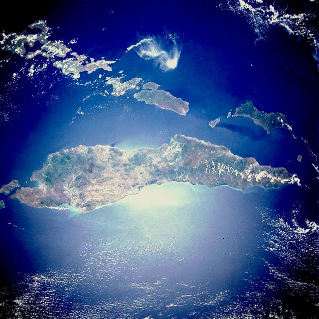
Timor is an island in Asia (Malay Archipelago), covering an estimated 28,881 km². It extends across Timor-Leste and Indonesia. About 50% of the island belongs to Timor-Leste, and the rest to Indonesia.
Timor (Indonesian: Pulau Timor; Portuguese: Ilha de Timor; Tetun: Illa Timór) is an island at the southern end of Maritime Southeast Asia, in the north of the Timor Sea. The name is a variant of timur, Malay for "east"; it is so called because it lies at the eastern end of the Lesser Sunda Islands. Mainland Australia is less than 500 km away, separated by the Timor Sea. The island covers an area of 30,777 square kilometres (11,883 square miles).
With a population of over 3 million people, the island is divided between the sovereign states of Timor-Leste in the eastern part and Indonesia in the western part. The Indonesian part, known as West Timor, is inhabited by around 2 million people and constitutes part of the province of East Nusa Tenggara. Timor-Leste, previously under Indonesian occupation from 1975 to 1999, has a population of around 1.3 million. Within West Timor lies an exclave of Timor-Leste called Oecusse District. The island had previously been divided between the Dutch and Portuguese colonial empires.
Adapted from Wikipedia: Timor (CC BY-SA 4.0).
- Feature class
- Island
- Mapped extent
- 28,881 km²
- Size rank
- #99 of 445 islands
- Region
- Asia
- Subregion
- Malay Archipelago
- Countries
- Timor-Leste, Indonesia
- Coordinates
- -9.7332°, 124.2249°
- Ranges:
- Maoke Mountains (Oceania), Hamersley Range (Oceania)
- Settlements:
- Dili (42 km)
More about Timor
Geography
Timor is located north of Australia and Oceania, and is one of the easternmost Sunda Islands and the easternmost of Lesser Sunda Islands. Together with Sumba, Babar and associated smaller islands, Timor forms the southern outer archipelago of the Lesser Sunda Islands with the inner islands of Flores, Alor and Wetar to the north, and beyond them Sulawesi.
Timor is the principal island of the Outer Banda Arc, which is being uplifted by arc-continent collision with the Australian continent. Timor consists mostly of rocks from the Australian continental margin that are accreted to the Banda Arc. It occupies a forearc position in front of the active volcanic arc that forms the islands in the Flores region to the north.
History
The earliest historical record about Timor island is the 13th-century Chinese Zhu Fan Zhi, where it is called Ti-wu and is noted for its sandalwood. In the 14th-century, Javanese Nagarakretagama, Canto 14, Timur is identified as an island within Majapahit's realm. Timor was incorporated into ancient Javanese, Chinese and Indian trading networks of the 14th century as an exporter of aromatic sandalwood, slaves, honey and wax, and was settled by both the Portuguese, in the end of the 16th century, and the Dutch, based in Kupang, in the mid-17th century.
As the nearest island with a European settlement at the time, Timor was the destination of William Bligh and seamen loyal to him following the infamous mutiny on the Bounty in 1789.
Geology
Timor is an aerially exposed portion of the Banda Forearc formed by collision of Eurasian oceanic crust and continental crust of the Australian plate. This is a unique convergent margin where a thick continental margin is forced under thinner oceanic crust. The result is a large accretionary wedge of imbricated thrust sheets composed of Cretaceous and Tertiary distal material of the Australian continental margin thrust on top of Australian continental shelf deposits. Timor is well known for its structural complexity. Debate continues about the nature of deformation of continental crust. Some researchers advocate shallow thin-skinned deformation, while others favor shallow thin-skinned with some basement deformation.
Timor also has potential for significant petroleum development.
Sections adapted from Wikipedia: Timor (CC BY-SA 4.0).
Timor: Key Facts
| Area | 30,777 km² |
|---|---|
| Population | 3,368,735 (2023) |
| Highest point | Tatamailau |
| Surrounded by | Timor Sea |
Facts from Wikidata Q83067 (CC0).
Visiting Timor
Timor is an elongated island in the Indonesian archipelago, to the north of Australia. The island is divided into two separate territories:
Timor-Leste, an independent republic since 2002
West Timor, part of the Indonesian province of Nusa Tenggara Timur (East Nusa Tenggara)
Travel notes adapted from Wikivoyage: Timor (CC BY-SA 4.0).
Countries Bordering Timor-Leste
Land and maritime neighbours.
More Maps in Asia
Timor-Leste: Quick Answers
- What is the capital of Timor-Leste?
- The capital of Timor-Leste is Dili.
- What is the population of Timor-Leste?
- Timor-Leste has a population of about 1.42 million, the #154 largest of 225 countries in YearMaps. Source: World Bank, 2025.
- How big is Timor-Leste?
- Timor-Leste covers 14,919 km², ranking #161 by area, with about 95 people per square kilometre.
- Which continent is Timor-Leste in?
- Timor-Leste is in Asia.
- Which countries border Timor-Leste?
- Timor-Leste shares a land or maritime border with Indonesia, Australia.
- What is the largest city in Timor-Leste?
- Dili is the largest city in Timor-Leste, with a metropolitan population of about 234,331.
- What is the highest mountain in Timor-Leste?
- The highest summit recorded for Timor-Leste in YearMaps is Tata Mailau at 2,986 m (9,797 ft). Summits on a border are counted for both countries.