Skip to content
YearMaps
Indonesia · Landforms

Mountain Ranges, Deserts and Landforms of Indonesia

New Guinea Highlands is the largest of the 4 mountain ranges, deserts and other landforms recorded for Indonesia, at 222,321 km², ahead of Barisan Mountains at 63,657 km². The full list follows.

How this list is built: Ranked by mapped area. Covers mountain ranges, deserts, plateaus, named glaciers, plains, basins, peninsulas and capes. One that crosses a border is listed under every country it lies in, with the area of the whole feature. It covers the mountain ranges, deserts and other landforms indexed in YearMaps, drawn from open geospatial data, and is not an exhaustive national register.

Landforms Listed
4
Top Ranked
222,321 km²
New Guinea Highlands
Second
63,657 km²
Barisan Mountains
Profiled Below
3
Photo, encyclopedia text and figures
Mountain Ranges, Deserts and Landforms of Indonesia
#NameArea
1New Guinea Highlands222,321 km²
2Barisan Mountains63,657 km²
3Maoke Mountains771 km²
4Datu Peninsula557 km²

The Landforms of Indonesia in Detail

The 3 mountain ranges, deserts and other landforms above that have an encyclopedia article, in the same order, each with its photograph, figures and the places around it.

New Guinea Highlands
Image via Wikimedia Commons (author and licence on the file page).

New Guinea Highlands

Range/mtn · 222,321 km²

New Guinea Highlands is a range/mtn in Oceania (Melanesia), covering an estimated 222,321 km². It extends across Papua New Guinea and Indonesia. It is the 13th-largest of the 216 mountain ranges with a mapped extent in YearMaps.

The New Guinea Highlands, also known as the Central Range or Central Cordillera, is a long chain of mountain ranges on the island of New Guinea, including the island's highest peak, Puncak Jaya, Indonesia, 16,024 ft (4,884 m), the highest mountain in Oceania. The range is home to many intermountain river valleys, many of which support thriving agricultural communities. The highlands run generally east-west the length of the island, which is divided politically between Indonesia in the west and Papua New Guinea in the east. These mountains stretch from the Weyland Mountains starting in Wondama Bay Regency in the west to the Milne Bay Province in the east.

Adapted from Wikipedia: New Guinea Highlands (CC BY-SA 4.0).

Feature class
Range/mtn
Mapped extent
222,321 km²
Size rank
#13 of 216 mountain ranges
Region
Oceania
Subregion
Melanesia
Countries
Papua New Guinea, Indonesia
Coordinates
-5.7013°, 143.9361°
Summits:
Puncak Jaya (4,884 m), Gunung Binaiya (3,027 m), Bulu Rantekombola (3,455 m)
Adjacent ranges:
Maoke Mountains (Oceania), Owen Stanley Range (Oceania)
Settlements:
Timika (170 km), Jayapura (309 km), Nabire (316 km)

View on the live map

More about New Guinea Highlands

Geography

The Central Cordillera, some peaks of which are capped with ice, consists of (from east to west): the Central Highlands and Eastern Highlands of Papua New Guinea including the Owen Stanley Range in the southeast, whose highest peak is Mount Victoria at 4,038 metres (13,248 feet), the Albert Victor Mountains, the Sir Arthur Gordon Range, and the Bismarck Range, whose highest peak is Mount Wilhelm at 4,509 metres (14,793 feet), which is an extinct volcano with a crater lake; the Star Mountains on the Papua New Guinea–Indonesia border; and the Maoke Mountains or Snow Range in Indonesia, where perpetual snow was found by H. A. Lorentz in 1909 at 4,461 m (14,635 ft), and whose highest peaks are Puncak Jaya (Mt. Carstensz) at 4,884 m (16,024 feet), Puncak Mandala (Mt. Juliana) at 4,760 m (15,610 ft) and Puncak Trikora (Mt. Wilhelmina) at 4,750 m (15,580 ft).

Geology

This chain of mountains continues to rise (with corresponding quakes) as the Australian Plate collides with the plates to the northeast, marking the southern boundaries of the Maoke and Woodlark plates. The width of the mountain range varies considerably, with a central thin segment near the borders of the two nations.

The surface geology of the highlands is made up of metamorphic and intrusive igneous rocks. The metamorphic rocks were Cretaceous and Eocene ocean sediments that were uplifted and folded between the Eocene and early Miocene periods. There are also Pleistocene stratovolcanoes in the highlands, including Mount Hagen and Mount Giluwe.

Ecology

The New Guinea Highlands are home to a great variety of Australasian plant and animal communities, distinct from the surrounding lowlands to the north and south of the central ranges and varying up and along the mountain ranges. The habitats of the mountains have been separated into two ecoregions, depending on their elevation, the tropical montane forests and alpine grasslands, but within these broad bands there is a variety of wildlife along the island as some of the mountains stand quite a distance from others with some species of plant or animal existing on only one or two mountains.

History

The fertile Highlands have long been inhabited and artifacts uncovered in the Ivane Valley indicate that the Highlands were first settled about 50,000 years ago. The inhabitants were nomadic foragers but around 10,000 years ago began developing a fairly advanced agricultural society. Before the introduction of the sweet potato, the Highlands had distinct forms of division of labor. In the Eastern Highlands the economy was mixed, with men hunting and cultivating, and women gathering and tending crops. Populations were small, dispersed, and focused on immediate consumption.

Sections adapted from Wikipedia: New Guinea Highlands (CC BY-SA 4.0).

New Guinea Highlands: Key Facts

Key facts about New Guinea Highlands
Highest pointPuncak Jaya

Facts from Wikidata Q2961771 (CC0).

Barisan Mountains
Image via Wikimedia Commons (author and licence on the file page).

Barisan Mountains

Range/mtn · 63,657 km²

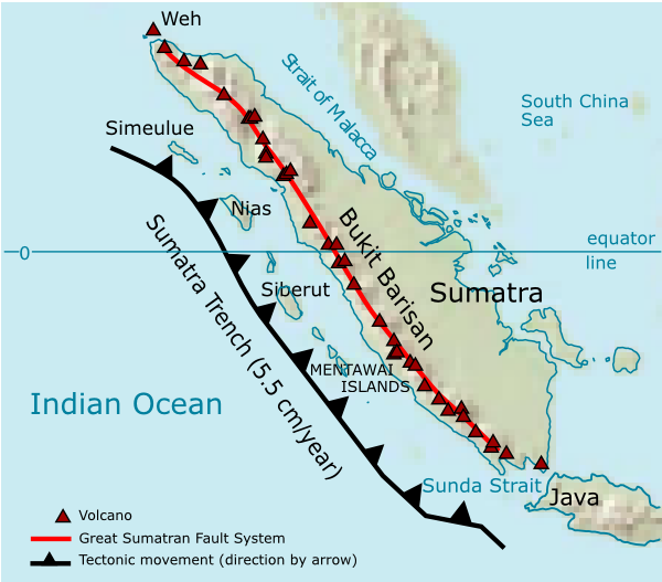
Barisan Mountains is a range/mtn in Asia (Malay Archipelago), covering an estimated 63,657 km².

The Bukit Barisan or the Barisan Mountains are a mountain range on the western side of Sumatra, Indonesia, covering nearly 1,700 km (1,050 mi) from the north to the south of the island. The Bukit Barisan range consists primarily of volcanoes shrouded in dense jungle cover, including Sumatran tropical pine forests on the higher slopes. The highest peak of the range is Mount Kerinci at 3,800 metres (12,467 ft). The Bukit Barisan Selatan National Park is situated towards the southern end of the range in Liwa, Indonesia.

Much of the mountain range is protected through a network of national parks, including Gunung Leuser, Kerinci Seblat, and Bukit Barisan Selatan. Together, these parks form the UNESCO World Heritage Site Tropical Rainforest Heritage of Sumatra, recognized in 2004 for its exceptional biodiversity and importance as habitat for critically endangered species such as the Sumatran orangutan, Sumatran tiger, and Sumatran rhinoceros.

The name Bukit Barisan actually means "row of hills" or "hills that make a row" in Malay, for the range stretches end to end along the island of Sumatra.

There are 35 active volcanoes in Bukit Barisan.

Adapted from Wikipedia: Barisan Mountains (CC BY-SA 4.0).

Feature class
Range/mtn
Mapped extent
63,657 km²
Size rank
#65 of 216 mountain ranges
Region
Asia
Subregion
Malay Archipelago
Coordinates
-3.7142°, 102.9119°
Summits:
Gunung Kerinci (3,805 m), Gunung Tahan (2,190 m), Gunung Merapi (2,968 m)
Adjacent ranges:
Dângrêk Range (Asia), Hamersley Range (Oceania)
Settlements:
Lahat (70 km), Bengkulu (72 km), Perabumulih (150 km)

View on the live map

More about Barisan Mountains

Barisan Mountains: Key Facts

Key facts about Barisan Mountains
Length1,700 km
Highest pointMount Kerinci

Facts from Wikidata Q649051 (CC0).

Maoke Mountains
Image via Wikimedia Commons (author and licence on the file page).

Maoke Mountains

Range/mtn · 771 km²

Maoke Mountains is a range/mtn in Oceania (Melanesia), covering an estimated 771 km².

The Maoke Mountains is a mountain range in the province of Central Papua and Highland Papua. It extends over 692 km and is composed of the Sudirman and Jayawijaya ranges. It is part of the larger New Guinea Highlands or Central Cordillera.

Although Maoke means 'snow' in the local language, the glacier on Puncak Trikora in the Maoke Mountains disappeared completely some time between 1939 and 1962.

Adapted from Wikipedia: Maoke Mountains (CC BY-SA 4.0).

Feature class
Range/mtn
Mapped extent
771 km²
Size rank
#184 of 216 mountain ranges
Region
Oceania
Subregion
Melanesia
Coordinates
-4.2362°, 135.8322°
Summits:
Puncak Jaya (4,884 m), Gunung Binaiya (3,027 m), Mount Wilhelm (4,509 m)
Adjacent ranges:
New Guinea Highlands (Oceania), Owen Stanley Range (Oceania)
Settlements:
Nabire (105 km), Timika (122 km), Biak (343 km)

View on the live map

More about Maoke Mountains

Maoke Mountains: Key Facts

Key facts about Maoke Mountains
Length700 km
Highest pointPuncak Jaya
Part ofNew Guinea Highlands

Facts from Wikidata Q1469703 (CC0).

More on Indonesia

Quick Answers

What is the largest landform in Indonesia?
New Guinea Highlands, at 222,321 km². Barisan Mountains is second at 63,657 km². Rankings cover the mountain ranges, deserts and other landforms indexed in YearMaps.
How many mountain ranges, deserts and other landforms are there in Indonesia?
YearMaps lists 4 mountain ranges, deserts and other landforms for Indonesia. This is the number mapped in the atlas, not an official national count.