
UNESCO World Heritage Sites in Russia
Russia has 34 sites on the UNESCO World Heritage List (23 cultural and 11 natural), the first inscribed in 1990 (Historic Centre of Saint Petersburg and Related Groups of Monuments). 1 site is on the List of World Heritage in Danger. The map below plots every one of them alongside the rest of the List, and each site is written up in full further down the page.
- World Heritage Sites
- 34
- Cultural
- 23
- Natural and Mixed
- 11
- First Inscribed
- 1990
Map of World Heritage Sites in Russia
CulturalNaturalMixedIn DangerLarge dots are in Russia. Click a dot to read about the site.

Historic Centre of Saint Petersburg and Related Groups of Monuments
Russia · 59.9389° N, 30.3156° E · 39 km² · 0 km from St. Petersburg
The Historic Centre of Saint Petersburg and Related Groups of Monuments is the name used by UNESCO when it collectively designated the historic core of the Russian city of St. Petersburg, as well as buildings and ensembles located in the immediate vicinity as a World Heritage Site in 1991.
The site was recognised for its architectural heritage, fusing Baroque, Neoclassical, and traditional Russian-Byzantine influences.
Adapted from Wikipedia: Historic Centre of Saint Petersburg and Related Groups of Monuments (CC BY-SA 4.0).
Why Historic Centre of Saint Petersburg and Related Groups of Monuments Is Listed
- (i)
- A masterpiece of human creative genius.
- (ii)
- An important interchange of human values.
- (iv)
- An outstanding example of a type of building or landscape.
- (vi)
- A direct association with events, ideas or beliefs of universal significance.
More about Historic Centre of Saint Petersburg and Related Groups of Monuments
UNESCO's Description
The 'Venice of the North', with its numerous canals and more than 400 bridges, is the result of a vast urban project begun in 1703 under Peter the Great. Later known as Leningrad (in the former USSR), the city is closely associated with the October Revolution. Its architectural heritage reconciles the very different Baroque and pure neoclassical styles, as can be seen in the Admiralty, the Winter Palace, the Marble Palace and the Hermitage.
From the UNESCO World Heritage Centre (CC BY-SA IGO 3.0).
Key Facts
| Area | 39.3 km² |
|---|
Facts from Wikidata Q616578 (CC0).

Kizhi Pogost
Russia · 62.0677° N, 35.2234° E · 51 km from Kondopoga
Kizhi Pogost (Russian: Кижский погост) is a historical site dating from the 17th century on Kizhi island. The island is located on Lake Onega in the Republic of Karelia (Medvezhyegorsky District), Russia. The pogost is the area inside a fence which includes two large wooden churches (the 22-dome Transfiguration Church and the 9-dome Intercession Church) and a bell-tower. The pogost is famous for its beauty and longevity, despite being built exclusively of wood. In 1990, it was included in the UNESCO list of World Heritage sites and in 1993 listed as a Russian Cultural Heritage site.
Adapted from Wikipedia: Kizhi Pogost (CC BY-SA 4.0).
Why Kizhi Pogost Is Listed
- (i)
- A masterpiece of human creative genius.
- (iv)
- An outstanding example of a type of building or landscape.
- (v)
- An outstanding example of traditional human settlement or land use.
More about Kizhi Pogost
UNESCO's Description
The pogost of Kizhi (i.e. the Kizhi enclosure) is located on one of the many islands in Lake Onega, in Karelia. Two 18th-century wooden churches, and an octagonal clock tower, also in wood and built in 1862, can be seen there. These unusual constructions, in which carpenters created a bold visionary architecture, perpetuate an ancient model of parish space and are in harmony with the surrounding landscape.
From the UNESCO World Heritage Centre (CC BY-SA IGO 3.0).

Kremlin and Red Square
Russia · 55.7536° N, 37.6200° E · 0 km from Moscow
Inextricably linked to all the most important historical and political events in Russia since the 13th century, the Kremlin (built between the 14th and 17th centuries by outstanding Russian and foreign architects) was the residence of the Great Prince and also a religious centre. At the foot of its ramparts, on Red Square, St Basil's Basilica is one of the most beautiful Russian Orthodox monuments.
Description from the UNESCO World Heritage Centre (CC BY-SA IGO 3.0).
Why Kremlin and Red Square Is Listed
- (i)
- A masterpiece of human creative genius.
- (ii)
- An important interchange of human values.
- (iv)
- An outstanding example of a type of building or landscape.
- (vi)
- A direct association with events, ideas or beliefs of universal significance.

Historic Monuments of Novgorod and Surroundings
Russia · 58.5183° N, 31.2856° E · 3 km from Velikiy Novgorod
The Historic Monuments of Novgorod and Surroundings is a composite World Heritage Site which includes a number of medieval monuments in and around Veliky Novgorod, Russia. The site was inscribed in 1992.
Adapted from Wikipedia: Historic Monuments of Novgorod and Surroundings (CC BY-SA 4.0).
Why Historic Monuments of Novgorod and Surroundings Is Listed
- (ii)
- An important interchange of human values.
- (iv)
- An outstanding example of a type of building or landscape.
- (vi)
- A direct association with events, ideas or beliefs of universal significance.
More about Historic Monuments of Novgorod and Surroundings
UNESCO's Description
Situated on the ancient trade route between Central Asia and northern Europe, Novgorod was Russia's first capital in the 9th century. Surrounded by churches and monasteries, it was a centre for Orthodox spirituality as well as Russian architecture. Its medieval monuments and the 14th-century frescoes of Theophanes the Greek (Andrei Rublev's teacher) illustrate the development of its remarkable architecture and cultural creativity.
From the UNESCO World Heritage Centre (CC BY-SA IGO 3.0).
History
Novgorod between the 9th and the 15th centuries was one of the most significant cities of medieval Rus. It lay on the trade route from the Varangians to the Greeks and was the center of the Novgorod Republic, which included the major part of what is currently northwestern Russia. From the 12th century, it was an example of a medieval republic, in which decisions were taken by veche – a meeting of the city population – and the prince was elected. (The only other Russian city with a similar organization was Pskov.) Novgorod was one of few areas of Rus not affected by the Mongol invasions, and therefore, in particular, active ecclesiastical construction was continuing in Novgorod in the 14th century, while it was stale in the rest of Rus.
Sections adapted from Wikipedia: Historic Monuments of Novgorod and Surroundings (CC BY-SA 4.0).

Solovetsky Islands
Russia · 65.0244° N, 35.7106° E · 288 km²
The Solovetsky Islands (Russian: Соловецкие острова, IPA: [səlɐˈvʲetskʲɪj ɐstrɐˈva]), or Solovki (Russian: Соловки, IPA: [səlɐfˈkʲi]), are an archipelago located in the Onega Bay of the White Sea, Russia. As an administrative division, the islands are incorporated as Solovetsky District of Arkhangelsk Oblast, Russia. Within the framework of municipal divisions, they are incorporated as Solovetskoye Rural Settlement within Primorsky Municipal District. The administrative center of both divisions is the settlement of Solovetsky, located on Bolshoy Solovetsky Island. Almost all of the population of the islands lives in Solovetsky. As of the 2010 Census, the district had a population of 861 inhabitants.
The Solovetsky Monastery (founded in 1436), in 1923 became the site of the first Gulag establishment, the Solovki prison camp.
Adapted from Wikipedia: Solovetsky Islands (CC BY-SA 4.0).
Why Solovetsky Islands Is Listed
- (iv)
- An outstanding example of a type of building or landscape.
More about Solovetsky Islands
UNESCO's Description
The Solovetsky archipelago comprises six islands in the western part of the White Sea, covering about 300 km 2 . They have been inhabited since the 5th century B.C. and important traces of a human presence from as far back as the 5th millennium B.C. can be found there. The archipelago has been the site of fervent monastic activity since the 15th century, and there are several churches dating from the 16th to the 19th century.
From the UNESCO World Heritage Centre (CC BY-SA IGO 3.0).
Geography
The islands separate the Onega Bay from the main volume of the White Sea. The closest mainland is the Onega Peninsula.
The shores of the islands are very indented. They are formed of granites and gneiss. The relief of the islands is hilly (the highest point is 107 m). Most of the Solovetsky Islands are covered with Scots Pine and Norway Spruce forests, which are partially swampy. There are numerous lakes, which were joined by monks so as to form a network of canals.
One interesting feature of these islands is stone labyrinths and other stone settings, especially the Stone labyrinths of Bolshoi Zayatsky Island. Such labyrinths were typical for Northern Europe, but most have perished and now Solovetsky Islands have some of the best remaining examples.
Sections adapted from Wikipedia: Solovetsky Islands (CC BY-SA 4.0).
Visiting Solovetsky Islands
The Solovetsky Islands are a group of islands in the White Sea in Arkhangelsk Oblast. It is a true pearl of Russian north. Several sites on the islands are inscribed on the UNESCO World Heritage List. They are part of the Silver Ring of cultural and historical centers of Northwestern Russia.
Travel notes adapted from Wikivoyage: Solovetsky Islands (CC BY-SA 4.0).

White Monuments of Vladimir and Suzdal
Russia · 56.1500° N, 40.4167° E · 2 km from Vladimir
The White Monuments of Vladimir and Suzdal in Vladimir Oblast, Russia, have been designated as a UNESCO World Heritage Site. The patrimony embraces eight medieval limestone monuments of Zalesye from the late 12th and early 13th centuries. They include Russian Orthodox churches and a monastery, as well as a castle and gate. It is a serial property, which means it is made up of multiple monuments.
Adapted from Wikipedia: White Monuments of Vladimir and Suzdal (CC BY-SA 4.0).
Why White Monuments of Vladimir and Suzdal Is Listed
- (i)
- A masterpiece of human creative genius.
- (ii)
- An important interchange of human values.
- (iv)
- An outstanding example of a type of building or landscape.
More about White Monuments of Vladimir and Suzdal
UNESCO's Description
These two artistic centres in central Russia hold an important place in the country's architectural history. There are a number of magnificent 12th- and 13th-century public and religious buildings, above all the masterpieces of the Collegiate Church of St Demetrios and the Cathedral of the Assumption of the Virgin.
From the UNESCO World Heritage Centre (CC BY-SA IGO 3.0).
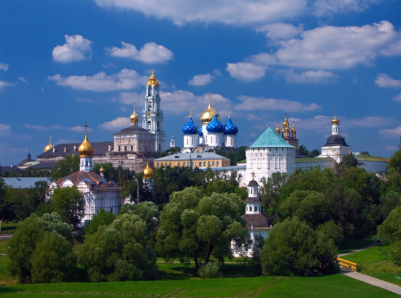
Trinity Lavra of St. Sergius
Russia · 56.3103° N, 38.1307° E · 3 km from Sergiyev Posad
The Trinity Lavra of St. Sergius (Russian: Троице-Сергиева лавра) is a lavra and the most important Russian monastery, being the spiritual centre of the Russian Orthodox Church. The monastery is situated in the town of Sergiyev Posad, about 70 kilometres (43 mi) to the northeast from Moscow by the road leading to Yaroslavl, and currently is home to over 300 monks.
Adapted from Wikipedia: Trinity Lavra of St. Sergius (CC BY-SA 4.0).
Why Trinity Lavra of St. Sergius Is Listed
- (ii)
- An important interchange of human values.
- (iv)
- An outstanding example of a type of building or landscape.
More about Trinity Lavra of St. Sergius
UNESCO's Description
This is a fine example of a working Orthodox monastery, with military features that are typical of the 15th to the 18th century, the period during which it developed. The main church of the Lavra, the Cathedral of the Assumption (echoing the Kremlin Cathedral of the same name), contains the tomb of Boris Godunov. Among the treasures of the Lavra is the famous icon, The Trinity , by Andrei Rublev.
From the UNESCO World Heritage Centre (CC BY-SA IGO 3.0).
History
The monastery was founded in 1337 by one of the most venerated Russian saints, Sergius of Radonezh, who built a wooden church in honour of the Holy Trinity on Makovets Hill. Early development of the monastic community is well documented in contemporary lives of Sergius and his disciples.
In 1355, Sergius introduced a charter which required the construction of auxiliary buildings, such as refectory, kitchen, and bakery. This charter was a model for Sergius' numerous followers who founded more than 400 monasteries all over Russia, including the celebrated Solovetsky, Kirillov, and Simonov monasteries.
St. Sergius supported Dmitri Donskoi in his struggle against the Tatars and sent two of his monks, Peresvet and Oslyabya, to participate in the Battle of Kulikovo (1380).
Sections adapted from Wikipedia: Trinity Lavra of St. Sergius (CC BY-SA 4.0).
Key Facts
| Established | 1337 |
|---|---|
| Area | 0.2 km² |
Facts from Wikidata Q211962 (CC0).

Church of the Ascension, Kolomenskoye
Russia · 55.6672° N, 37.6708° E · 10 km from Moscow
The Church of the Ascension was built in 1532 on the imperial estate of Kolomenskoye, near Moscow, to celebrate the birth of the prince who was to become Tsar Ivan IV ('the Terrible'). One of the earliest examples of a traditional wooden tent-roofed church on a stone and brick substructure, it had a great influence on the development of Russian ecclesiastical architecture.
Description from the UNESCO World Heritage Centre (CC BY-SA IGO 3.0).
Why Church of the Ascension, Kolomenskoye Is Listed
- (ii)
- An important interchange of human values.

Virgin Komi Forests
Russia · 65.0667° N, 60.1500° E · 32,800 km² · 108 km from Inta
The Virgin Komi Forests (Komi: Комилӧн вӧрзьӧдлытӧм вӧръяс, Russian: Девственные леса Коми) is a natural UNESCO World Heritage Site in the Northern Ural Mountains of the Komi Republic, Russia. At 32,800 km2 it is the largest virgin forest in Europe.
Adapted from Wikipedia: Virgin Komi Forests (CC BY-SA 4.0).
Why Virgin Komi Forests Is Listed
- (vii)
- Superlative natural phenomena or exceptional natural beauty.
- (ix)
- An outstanding example of ongoing ecological and biological processes.
More about Virgin Komi Forests
UNESCO's Description
The Virgin Komi Forests cover 3.28 million ha of tundra and mountain tundra in the Urals, as well as one of the most extensive areas of virgin boreal forest remaining in Europe. This vast area of conifers, aspens, birches, peat bogs, rivers and natural lakes has been monitored and studied for over 50 years. It provides valuable evidence of the natural processes affecting biodiversity in the taiga.
From the UNESCO World Heritage Centre (CC BY-SA IGO 3.0).
Geography and ecology
The Virgin Komi Forests, located in the northeastern part of European Russia, encompasses approximately 3.28 million hectares, making them the largest expanse of virgin boreal forest in Europe. This vast area includes diverse landscapes such as tundra, alpine tundra, and boreal forests, situated west of the Ural Mountains in the Komi Republic.
The region's flora is dominated by coniferous species, including Siberian spruce, Siberian fir, and Siberian larch. Deciduous trees like aspen and birch are also prevalent, contributing to the area's rich biodiversity. The forests serve as a haven for rare species and contain one of Europe's most valuable stores of genetic and biological diversity.
Sections adapted from Wikipedia: Virgin Komi Forests (CC BY-SA 4.0).
Key Facts
| Established | 1995 |
|---|---|
| Area | 32,800 km² |
Facts from Wikidata Q593870 (CC0).

Lake Baikal
Russia · 53.3028° N, 108.0047° E · 88,000 km²
Lake Baikal is a rift lake and the deepest lake in the world. It is situated in southern Siberia, Russia, between the federal subjects of Irkutsk Oblast to the northwest and the Republic of Buryatia to the southeast.
At 31,722 km2 (12,248 sq mi)—slightly larger than Belgium—Lake Baikal is the world's seventh-largest lake by surface area, as well as the second-largest lake in Eurasia after the Caspian Sea. However, because it is also the deepest lake, with a maximum depth of 1,642 metres (5,387 feet), Lake Baikal is the world's largest freshwater lake by volume, containing 23,615.39 km3 (5,670 cu mi) of water or 22–23% of the world's fresh surface water, more than all of the North American Great Lakes combined. It is also the world's oldest lake at 25–30 million years, and among the clearest. It is estimated that the lake contains around 19% of the unfrozen fresh water on the planet.
Lake Baikal is home to thousands of species of plants and animals, many of them endemic to the region.
Adapted from Wikipedia: Lake Baikal (CC BY-SA 4.0).
Why Lake Baikal Is Listed
- (vii)
- Superlative natural phenomena or exceptional natural beauty.
- (viii)
- An outstanding example of major stages of the Earth's history.
- (ix)
- An outstanding example of ongoing ecological and biological processes.
- (x)
- The most important natural habitats for conserving biodiversity.
More about Lake Baikal
UNESCO's Description
Situated in south-east Siberia, the 3.15-million-ha Lake Baikal is the oldest (25 million years) and deepest (1,700 m) lake in the world. It contains 20% of the world's total unfrozen freshwater reserve. Known as the 'Galapagos of Russia', its age and isolation have produced one of the world's richest and most unusual freshwater faunas, which is of exceptional value to evolutionary science.
From the UNESCO World Heritage Centre (CC BY-SA IGO 3.0).
Geography and hydrography
Lake Baikal is in a rift valley, created by the Baikal Rift Zone, where the Earth's crust is slowly pulling apart. At 636 km (395 mi) long and 79 km (49 mi) wide, Lake Baikal has the largest surface area of any freshwater lake in Asia, at 31,722 km2 (12,248 sq mi), and is the deepest lake in the world at 1,642 metres (5,387 feet; 898 fathoms). The surface of the lake is 455.5 m (1,494 ft) above sea level, while the bottom of the lake is 1,186.5 m (3,893 ft; 648.8 fathoms) below sea level, and below this lies some 7 km (4.3 mi) of sediment, placing the rift floor some 8–11 km (5.0–6.8 mi) below the surface, the deepest continental rift on Earth.
In geological terms, the rift is young and active—it widens about 4 mm (0.16 in) per year.
Ecology
Lake Baikal is rich in biodiversity. It hosts more than 1,000 species of plants and 2,500 species of animals based on current knowledge, but the actual figures for both groups are believed to be significantly higher.
The watershed of Lake Baikal has numerous floral species represented. The marsh thistle (Cirsium palustre) is found here at the eastern limit of its geographic range.
Submerged macrophytic vascular plants are mostly absent, except in some shallow bays along the shores of Lake Baikal. More than 85 species of submerged macrophytes have been recorded, including genera such as Ceratophyllum, Myriophyllum, Potamogeton, and Sparganium. The invasive species Elodea canadensis was introduced to the lake in the 1950s.
Sections adapted from Wikipedia: Lake Baikal (CC BY-SA 4.0).
Visiting Lake Baikal
Lake Baikal (Russian: Байка́л bigh-KAHL) is a lake in Eastern Siberia, Russia. It is the biggest and deepest freshwater lake in the world, and a UNESCO World Heritage Site.
Travel notes adapted from Wikivoyage: Lake Baikal (CC BY-SA 4.0).

Volcanoes of Kamchatka
Russia · 55.6700° N, 157.6699° E · 39,958 km²
This is one of the most outstanding volcanic regions in the world, with a high density of active volcanoes, a variety of types, and a wide range of related features. The six sites included in the serial designation group together the majority of volcanic features of the Kamchatka peninsula. The interplay of active volcanoes and glaciers forms a dynamic landscape of great beauty. The sites contain great species diversity, including the world's largest known variety of salmonoid fish and exceptional concentrations of sea otter, brown bear and Stellar's sea eagle.
Description from the UNESCO World Heritage Centre (CC BY-SA IGO 3.0).
Why Volcanoes of Kamchatka Is Listed
- (vii)
- Superlative natural phenomena or exceptional natural beauty.
- (viii)
- An outstanding example of major stages of the Earth's history.
- (ix)
- An outstanding example of ongoing ecological and biological processes.
- (x)
- The most important natural habitats for conserving biodiversity.

Golden Mountains of Altai
Russia · 50.4667° N, 86.0000° E · 16,115 km² · 148 km from Zyryanovsk
Golden Mountains of Altai is the name of an UNESCO World Heritage Site consisting of the Altai and Katun Natural Reserves, Lake Teletskoye, Belukha Mountain, and the Ukok Plateau in Russia. As stated in the UNESCO description of the site, "the region represents the most complete sequence of altitudinal vegetation zones in central Siberia, from steppe, forest-steppe, mixed forest, subalpine vegetation to alpine vegetation". While making its decision, UNESCO also cited Russian Altai's importance for preservation of the globally endangered mammals, such as the snow leopard, Altai argali, and Siberian ibex. The site covers a vast area of 16,178 km2 (6,246 sq mi).
Adapted from Wikipedia: Golden Mountains of Altai (CC BY-SA 4.0).
Why Golden Mountains of Altai Is Listed
- (x)
- The most important natural habitats for conserving biodiversity.
More about Golden Mountains of Altai
UNESCO's Description
The Altai mountains in southern Siberia form the major mountain range in the western Siberia biogeographic region and provide the source of its greatest rivers – the Ob and the Irtysh. Three separate areas are inscribed: Altaisky Zapovednik and a buffer zone around Lake Teletskoye; Katunsky Zapovednik and a buffer zone around Mount Belukha; and the Ukok Quiet Zone on the Ukok plateau. The total area covers 1,611,457 ha. The region represents the most complete sequence of altitudinal vegetation zones in central Siberia, from steppe, forest-steppe, mixed forest, subalpine vegetation to alpine vegetation. The site is also an important habitat for endangered animal species such as the snow leopard.
From the UNESCO World Heritage Centre (CC BY-SA IGO 3.0).
Climate threats
Climate change has caused the melting of the permafrost endangering the preservation of these tombs. Over the past 100 years there has been a 1 °C (1.8 °F) increase in temperature across Asia and a 2 °C (3.6 °F) increase in temperature in the footsteps of the Altai, with the increase more pronounced in the winter and spring.
Glacial outburst floods have become a problem in this area. In particular, the Sofiyskiy Glacier in the region has been retreating at a rate of 18 m (59 ft) per year.
A rise in temperature also poses a threat to the various endangered species that are housed in the mountain region. The species found in this area include the Snow leopard, Altai argali, Steppe eagle, and Black stork.
Sections adapted from Wikipedia: Golden Mountains of Altai (CC BY-SA 4.0).
Western Caucasus
Russia · 44.0000° N, 40.0000° E · 2,989 km² · 50 km from Sochi
The Western Caucasus, extending over 275,000 ha of the extreme western end of the Caucasus mountains and located 50 km north-east of the Black Sea, is one of the few large mountain areas of Europe that has not experienced significant human impact. Its subalpine and alpine pastures have only been grazed by wild animals, and its extensive tracts of undisturbed mountain forests, extending from the lowlands to the subalpine zone, are unique in Europe. The site has a great diversity of ecosystems, with important endemic plants and wildlife, and is the place of origin and reintroduction of the mountain subspecies of the European bison.
Description from the UNESCO World Heritage Centre (CC BY-SA IGO 3.0).
Why Western Caucasus Is Listed
- (ix)
- An outstanding example of ongoing ecological and biological processes.
- (x)
- The most important natural habitats for conserving biodiversity.

Ferapontov Monastery
Russia · 59.9564° N, 38.5675° E · 98 km from Cherepovets
The Ferapontov Monastery is a monastery of the Russian Orthodox Church in Ferapontovo, Kirillovsky District, Vologda Oblast, Russia. The monastery was founded by Saint Ferapont in 1398. In 2000, the monastery was added to the UNESCO list of World Heritage Sites.
Adapted from Wikipedia: Ferapontov Monastery (CC BY-SA 4.0).
Why Ferapontov Monastery Is Listed
- (i)
- A masterpiece of human creative genius.
- (iv)
- An outstanding example of a type of building or landscape.
More about Ferapontov Monastery
UNESCO's Description
The Ferapontov Monastery, in the Vologda region in northern Russia, is an exceptionally well-preserved and complete example of a Russian Orthodox monastic complex of the 15th-17th centuries, a period of great significance in the development of the unified Russian state and its culture. The architecture of the monastery is outstanding in its inventiveness and purity. The interior is graced by the magnificent wall paintings of Dionisy, the greatest Russian artist of the end of the 15th century.
From the UNESCO World Heritage Centre (CC BY-SA IGO 3.0).
History
The monastery was founded by Saint Ferapont in 1398 in the Russian North, to the east from the Kirillo-Belozersky Monastery, named after his fellow monk, Saint Cyril of Beloozero. The fame of the monastery started to spread under Kirill's disciple, Saint Martinian, who was to become a father superior of the Troitse-Sergiyeva Lavra in 1447.
Even after Martinian's death, his monastery was protected and favoured by members of Ivan III's family. The most ancient structure, the Cathedral of Nativity of the Virgin (1490), was built in brick by the masters of Rostov. This edifice is the best preserved of three sister cathedrals erected in the 1490s in the Russian North. All the interior walls are covered with invaluable frescoes by the great medieval painter Dionisius.
Sections adapted from Wikipedia: Ferapontov Monastery (CC BY-SA 4.0).
Key Facts
| Established | 1398 |
|---|---|
| Architectural style | Russian architecture |
Facts from Wikidata Q838256 (CC0).

Qazan Kremlin
Russia · 55.7974° N, 49.1072° E · 5 km from Kazan
The Kazan Kremlin (Russian: Казанский кремль; Tatar: Казан кирмәне) is the chief historic citadel of Kazan, a city in Russia. It was built at the behest of Ivan the Terrible on the ruins of the former castle of Kazan khans. It was declared a World Heritage Site in 2000.
Adapted from Wikipedia: Kazan Kremlin (CC BY-SA 4.0).
Why Qazan Kremlin Is Listed
- (ii)
- An important interchange of human values.
- (iii)
- A unique testimony to a cultural tradition or civilisation.
- (iv)
- An outstanding example of a type of building or landscape.
More about Qazan Kremlin
UNESCO's Description
Built on an ancient site, the Kazan Kremlin dates from the Muslim period of the Golden Horde and the Kazan Khanate. It was conquered by Ivan the Terrible in 1552 and became the Christian See of the Volga Land. The only surviving Tatar fortress in Russia and an important place of pilgrimage, the Kazan Kremlin consists of an outstanding group of historic buildings dating from the 16th to 19th centuries, integrating remains of earlier structures of the 10th to 16th centuries.
From the UNESCO World Heritage Centre (CC BY-SA IGO 3.0).
History and monuments
The Kazan Kremlin includes many old buildings, the oldest of which is the Annunciation Cathedral (1554–1562), the only 16th-century Russian church to have six piers and five apses. Like many of Kazan's buildings of the period, it is constructed of local pale sandstone rather than of brick. The renowned Pskov architects Postnik Yakovlev and Ivan Shirjay (called Barma) were invited by the Tsar to rebuild the Kazan Kremlin in stone. The cathedral bell tower was erected in five tiers at the urging of Ivan the Terrible and was scored to resemble the Ivan the Great Belltower in Moscow, but was pulled down by the Soviets in 1930.
The most conspicuous landmark of the Kazan Kremlin is the leaning Söyembikä Tower, which probably goes back to the reign of Peter the Great.
Sections adapted from Wikipedia: Kazan Kremlin (CC BY-SA 4.0).

Central Sikhote-Alin
Russia · 46.6833° N, 136.6611° E · 15,668 km²
The Sikhote-Alin mountain range contains one of the richest and most unusual temperate forests of the world. In this mixed zone between taiga and subtropics, southern species such as the tiger and Himalayan bear cohabit with northern species such as the brown bear and lynx. After its extension in 2018, the property includes the Bikin River Valley, located about 100 km to the north of the existing site. It encompasses the South-Okhotsk dark coniferous forests and the East-Asian coniferous broadleaf forests. The fauna includes species of the taiga alongside southern Manchurian species. It includes notable mammals such as the Amur Tiger, Siberian Musk Deer, Wolverine and Sable.
Description from the UNESCO World Heritage Centre (CC BY-SA IGO 3.0).
Why Central Sikhote-Alin Is Listed
- (x)
- The most important natural habitats for conserving biodiversity.

Derbent Lighthouse
Russia · 42.0613° N, 48.2960° E · 2 km from Derbent
The Derbent Lighthouse is the southernmost lighthouse in Russia, located in the city of Derbent, a city in the Russian Republic of Dagestan. It is in the center of the city, on the fortress wall between the parks named after Sergei Kirov and Nizami Ganjavi and about half a kilometer from the coastline. The lighthouse is included in the list of protected monuments of Russia and is included in the historical list of UNESCO.
Adapted from Wikipedia: Derbent Lighthouse (CC BY-SA 4.0).
Why Derbent Lighthouse Is Listed
- (iii)
- A unique testimony to a cultural tradition or civilisation.
- (iv)
- An outstanding example of a type of building or landscape.
More about Derbent Lighthouse
UNESCO's Description
The Citadel, Ancient City and Fortress Buildings of Derbent were part of the northern lines of the Sasanian Persian Empire, which extended east and west of the Caspian Sea. The fortification was built in stone. It consisted of two parallel walls that formed a barrier from the seashore up to the mountain. The town of Derbent was built between these two walls, and has retained part of its medieval fabric. The site continued to be of great strategic importance until the 19th century.
From the UNESCO World Heritage Centre (CC BY-SA IGO 3.0).
History
Derbent as a seaport has been known since very ancient times, but the ancient authors never mentioned the existence of such an important attribute of the port as a lighthouse in Derbent.
For the first time, Russian ships appeared in the area of the Derbent fortress in the 60s of the 16th century, when Russian troops made a number of campaigns on the western coast of the Caspian Sea.
After the Russo-Persian War of 1826–1828, Russia received the exclusive right to have a military fleet on the Caspian Sea, and Russian and Persian merchant ships to sail freely in all directions.
Sections adapted from Wikipedia: Derbent Lighthouse (CC BY-SA 4.0).

Uvs Nuur Basin
Russia · 50.2750° N, 92.7197° E · 8,981 km² · 57 km from Ulaangom
The Uvs Nuur Basin (1,068,853 ha), is the northernmost of the enclosed basins of Central Asia. It takes its name from Uvs Nuur Lake, a large, shallow and very saline lake, important for migrating birds, waterfowl and seabirds. The site is made up of twelve protected areas representing the major biomes of eastern Eurasia. The steppe ecosystem supports a rich diversity of birds and the desert is home to a number of rare gerbil, jerboas and the marbled polecat. The mountains are an important refuge for the globally endangered snow leopard, mountain sheep (argali) and the Asiatic ibex.
Description from the UNESCO World Heritage Centre (CC BY-SA IGO 3.0).
Why Uvs Nuur Basin Is Listed
- (ix)
- An outstanding example of ongoing ecological and biological processes.
- (x)
- The most important natural habitats for conserving biodiversity.

Novodevichy Convent
Russia · 55.7260° N, 37.5566° E · 5 km from Moscow
Novodevichy Convent (Russian pronunciation: [nəvɐˈdʲevʲɪt͡ɕɪj]), also known as Bogoroditse-Smolensky Monastery (Russian: Новоде́вичий монасты́рь, Богоро́дице-Смоле́нский монасты́рь), is probably the best-known cloister of Moscow. Its name, sometimes translated as the New Maidens' Monastery, was devised to differ from the Old Maidens' Monastery within the Moscow Kremlin. The convent was founded by Grand Duke Vasily III on May 13, 1524 in honor of the Smolensk Icon of the Mother of God "Hodegetria" - the main shrine of Smolensk, in gratitude for the capture of Smolensk in 1514. Unlike other Moscow cloisters, it has remained virtually intact since the 17th century. In 2004, it was proclaimed a UNESCO World Heritage Site.
Adapted from Wikipedia: Novodevichy Convent (CC BY-SA 4.0).
Why Novodevichy Convent Is Listed
- (i)
- A masterpiece of human creative genius.
- (iv)
- An outstanding example of a type of building or landscape.
- (vi)
- A direct association with events, ideas or beliefs of universal significance.
More about Novodevichy Convent
UNESCO's Description
The Novodevichy Convent, in south-western Moscow, built in the 16th and 17th centuries in the so-called Moscow Baroque style, was part of a chain of monastic ensembles that were integrated into the defence system of the city. The convent was directly associated with the political, cultural and religious history of Russia, and closely linked to the Moscow Kremlin. It was used by women of the Tsar’s family and the aristocracy. Members of the Tsar’s family and entourage were also buried in its cemetery. The convent provides an example of the highest accomplishments of Russian architecture with rich interiors and an important collection of paintings and artefacts.
From the UNESCO World Heritage Centre (CC BY-SA IGO 3.0).
History of the convent
Vasili III, the Grand Prince of Moscow, founded the Novodevichy Convent in 1524 in commemoration of his conquest of Smolensk in 1514. The structure began as a fortress at a curve of the Moskva River three versts to the south-west of the Moscow Kremlin. It became an important part of the southern defensive belt of Moscow, which had already included a number of other monasteries. Upon its founding, the Novodevichy Convent was granted 3,000 rubles and the villages of Akhabinevo and Troparevo. Vasili's son, tsar Ivan the Terrible (reigned 1533–1584), would later grant a number of other villages to the convent.
Sections adapted from Wikipedia: Novodevichy Convent (CC BY-SA 4.0).
Key Facts
| Established | 1524 |
|---|---|
| Area | 0.1 km² |
Facts from Wikidata Q270725 (CC0).

Zapovednik Wrangel Island
Russia · 71.2333° N, 179.4000° E · 19,163 km²
Located well above the Arctic Circle, the site includes the mountainous Wrangel Island (7,608 km2), Herald Island (11 km 2 ) and surrounding waters. Wrangel was not glaciated during the Quaternary Ice Age, resulting in exceptionally high levels of biodiversity for this region. The island boasts the world’s largest population of Pacific walrus and the highest density of ancestral polar bear dens. It is a major feeding ground for the grey whale migrating from Mexico and the northernmost nesting ground for 100 migratory bird species, many endangered. Currently, 417 species and subspecies of vascular plants have been identified on the island, double that of any other Arctic tundra territory of comparable size and more than any other Arctic island. Some species are derivative of widespread continental forms, others are the result of recent hybridization, and 23 are endemic.
Description from the UNESCO World Heritage Centre (CC BY-SA IGO 3.0).
Why Zapovednik Wrangel Island Is Listed
- (ix)
- An outstanding example of ongoing ecological and biological processes.
- (x)
- The most important natural habitats for conserving biodiversity.

historical centre of Yaroslavl
Russia · 57.6236° N, 39.8875° E · 1 km² · 1 km from Yaroslavl
Situated at the confluence of the Volga and Kotorosl Rivers some 250 km north-east of Moscow, the historic city of Yaroslavl developed into a major commercial centre from the 11th century. It is renowned for its numerous 17th-century churches and is an outstanding example of the urban planning reform Empress Catherine the Great ordered for the whole of Russia in 1763. While keeping some of its significant historic structures, the town was renovated in the neoclassical style on a radial urban master plan. It has also kept elements from the 16th century in the Spassky Monastery, one of the oldest in the Upper Volga region, built on the site of a pagan temple in the late 12th century but reconstructed over time.
Description from the UNESCO World Heritage Centre (CC BY-SA IGO 3.0).
Why historical centre of Yaroslavl Is Listed
- (ii)
- An important interchange of human values.
- (iv)
- An outstanding example of a type of building or landscape.

Putorana Plateau
Russia · 69.0000° N, 93.0000° E · 18,873 km²
The Putorana Plateau (Russian: плато Путорана, romanized: plato Putorana) or the Putorana Mountains is a mountainous area in Russia.
It is a large massif or plateau crossed by mountain ranges. The nearest large settlement is Norilsk, where foreign travel is restricted. The city is served by Alykel Airport.
The area of the mountains contains some of the largest known nickel deposits in the world.
Adapted from Wikipedia: Putorana Plateau (CC BY-SA 4.0).
Why Putorana Plateau Is Listed
- (vii)
- Superlative natural phenomena or exceptional natural beauty.
- (ix)
- An outstanding example of ongoing ecological and biological processes.
More about Putorana Plateau
UNESCO's Description
This site coincides with the area of the Putoransky State Nature Reserve, and is located in the central part of the Putorana Plateau in northern Central Siberia. It is situated about 100 km north of the Arctic Circle. The part of the plateau inscribed on the World Heritage List harbours a complete set of subarctic and arctic ecosystems in an isolated mountain range, including pristine taiga, forest tundra, tundra and arctic desert systems, as well as untouched cold-water lake and river systems. A major reindeer migration route crosses the property, which represents an exceptional, large-scale and increasingly rare natural phenomenon.
From the UNESCO World Heritage Centre (CC BY-SA IGO 3.0).
Geography
The Putorana Plateau is a high-lying plateau crossed by mountain ranges at the northwestern edge of the Central Siberian Plateau. It is located east of the Yenisei River valley, between 67° and 70° N of latitude, southwest of the Anabar Plateau, north of the Syverma and Tunguska plateaus and south of the North Siberian Lowland. The main subranges of the Putorana are the Keta Range, Lontokoisky Kamen, Kharayelakh Range, Chaya-Ayan, Brus Kamen, and Lama Range, among others. The highest mountain in the range system is Mount Kamen which stands 1,678 m (5,505 ft) above sea level and is also the highest point of the Central Siberian Plateau. Talnikovy Waterfall is reputedly one of the highest waterfalls in Asia.
Climate
The Putorana region is located above the Arctic Circle. The climate is a harsh subarctic, sharply continental, with long, severely cold winters, and short, cool summers. However, in certain lake valleys, such as Lake Lama, there is a somewhat milder microclimate owing to the protection afforded by neighboring ranges from the northern winds. The higher elevations within the plateau transition to a tundra climate.
Spring, summer and autumn fall respectively in the months of June, July, and August, the remaining months are winter with temperatures between −32 °C (−26 °F) and −40 °C (−40 °F). In July, the warmest month, average air temperatures stay around 8 °C (46 °F) and may reach a maximum of 16 °C (61 °F).
Sections adapted from Wikipedia: Putorana Plateau (CC BY-SA 4.0).

Lena Pillars
Russia · 61.1069° N, 127.3617° E · 13,870 km²
The Lena Pillars (Russian: Ле́нские столбы́, romanized: Lenskiye Stolby; Yakut: Өлүөнэ туруук хайалара, Ölüöne Turūk Khayalara) are a natural rock formation along the banks of the Lena River in far eastern Siberia. The pillars are 150–300 metres (490–980 ft) high, and were formed in some of the Cambrian period sea-basins. The highest density of pillars is reached between the villages of Petrovskoye and Tit-Ary. The Lena Pillars Nature Park was inscribed on the World Heritage List in 2012.
The site lies around 180 kilometres (110 mi) (less than a day's boat ride) from the city of Yakutsk, the capital of the autonomous Sakha Republic.
Adapted from Wikipedia: Lena Pillars (CC BY-SA 4.0).
Why Lena Pillars Is Listed
- (viii)
- An outstanding example of major stages of the Earth's history.
More about Lena Pillars
UNESCO's Description
Lena Pillars Nature Park is marked by spectacular rock pillars that reach a height of approximately 100 m along the banks of the Lena River in the central part of the Sakha Republic (Yakutia). They were produced by the region’s extreme continental climate with an annual temperature range of almost 100 degrees Celsius (from –60 °C in winter to +40 °C in summer). The pillars form rocky buttresses isolated from each other by deep and steep gullies developed by frost shattering directed along intervening joints. Penetration of water from the surface has facilitated cryogenic processes (freeze-thaw action), which have widened gullies between pillars leading to their isolation. Fluvial processes are also critical to the pillars. The site also contains a wealth of Cambrian fossil remains of numerous species, some of them unique.
From the UNESCO World Heritage Centre (CC BY-SA IGO 3.0).
Geology
The pillars consist of alternating layers of limestone, marlstone, dolomite and slate of early to middle Cambrian age, which are weathered, producing the rugged outcrops.
These types of rocks are commonly formed in marine environments and the horizontal layering and vertical variation indicates marine transgression/regression; with the slate representing the deep marine, slightly metamorphosed shales.
Tourism
River cruises can be arranged through travel services in the city of Yakutsk. Visitors interested in limnology or ecotourism, including those who also visit Lake Baikal, may organise a river trip with the assistance of a guide from the Lake Baikal region; Yakutsk, from where the river cruises originate, is approximately 1,400 kilometres (870 mi) northeast of Lake Baikal.
Few modern amenities exist in this part of Russia, unless one travels by cruise ship on the Lena River. Tit-Ary on the opposite side of the river is connected to Yakutsk by a gravel road.
Sections adapted from Wikipedia: Lena Pillars (CC BY-SA 4.0).

Bolgar Historical and Archaeological Complex
Russia · 54.9789° N, 49.0564° E · 4 km² · 83 km from Ulyanovsk
This property lies on the shores of the Volga River, south of its confluence with the River Kama, and south of the capital of Tatarstan, Kazan. It contains evidence of the medieval city of Bolgar, an early settlement of the civilization of Volga-Bolgars, which existed between the 7th and 15th centuries AD, and was the first capital of the Golden Horde in the 13th century. Bolgar represents the historical cultural exchanges and transformations of Eurasia over several centuries that played a pivotal role in the formation of civilizations, customs and cultural traditions. The property provides remarkable evidence of historic continuity and cultural diversity. It is a symbolic reminder of the acceptance of Islam by the Volga-Bolgars in AD 922 and remains a sacred pilgrimage destination to the Tatar Muslims.
Description from the UNESCO World Heritage Centre (CC BY-SA IGO 3.0).
Why Bolgar Historical and Archaeological Complex Is Listed
- (ii)
- An important interchange of human values.
- (vi)
- A direct association with events, ideas or beliefs of universal significance.

Landscapes of Dauria
Russia · 49.9302° N, 115.4254° E · 9,126 km² · 93 km from Borzya
The Landscapes of Dauria is a World Heritage Site shared between Russia and Mongolia, part of the "Daurian forest steppe" ecoregion (the latter also stretches into the northeastern China). It is part of the Dauria International Protected Area and includes the Torey Lakes.
Adapted from Wikipedia: Landscapes of Dauria (CC BY-SA 4.0).
Why Landscapes of Dauria Is Listed
- (ix)
- An outstanding example of ongoing ecological and biological processes.
- (x)
- The most important natural habitats for conserving biodiversity.
More about Landscapes of Dauria
UNESCO's Description
Shared between Mongolia and the Russian Federation, this site is an outstanding example of the Daurian Steppe eco-region, which extends from eastern Mongolia into Russian Siberia and northeastern China. Cyclical climate changes, with distinct dry and wet periods lead to a wide diversity of species and ecosystems of global significance. The different types of steppe ecosystems represented, such as grassland and forest, as well as lakes and wetlands serve as habitats for rare species of fauna, such as the White-naped crane, Great Bustard, Relict Gull and Swan goose, as well as millions of vulnerable, endangered or threatened migratory birds. It is also a critical site on the transboundary migration path for the Mongolian gazelle.
From the UNESCO World Heritage Centre (CC BY-SA IGO 3.0).

Sviyazhsk Assumption Monastery
Russia · 55.7701° N, 48.6525° E · 8 km from Zelenodolsk
The Sviyazhsk Assumption Monastery (Russian: Свияжский Успенский монастырь) in Sviyazhsk, Republic of Tatarstan, Russia is a male Russian Orthodox monastery, included in UNESCO World Heritage list. It is said to be situated on the town-island of Sviyazhsk, but actually there is a road access by earth to the main territory. It was built in 1555, in the same time as Diocese of Kazan was established, and was the main educational and enlightenment center there during XVI—XVIII centuries, in the program of Russian tzar Ivan the Terrible to colonize Volga region. In particular, it had one of the first printing presses in Russia, along with Moscow Print Yard. The frescoes of the Orthodox monastery are among the best preserved in Russia.
Adapted from Wikipedia: Sviyazhsk Assumption Monastery (CC BY-SA 4.0).
Why Sviyazhsk Assumption Monastery Is Listed
- (ii)
- An important interchange of human values.
- (iv)
- An outstanding example of a type of building or landscape.
More about Sviyazhsk Assumption Monastery
UNESCO's Description
The Assumption Cathedral is located in the town-island of Sviyazhsk and is part of the monastery of the same name. Situated at the confluence of the Volga, the Sviyaga and the Shchuka rivers, at the crossroads of the Silk and Volga routes, Sviyazhsk was founded by Ivan the Terrible in 1551. It was from this outpost that he initiated the conquest of the Kazan Khanate. The Assumption Monastery illustrates in its location and architectural composition the political and missionary programme developed by Tsar Ivan IV to extend the Moscow state. The cathedral’s frescoes are among the rarest examples of Eastern Orthodox mural paintings.
From the UNESCO World Heritage Centre (CC BY-SA IGO 3.0).
Key Facts
| Established | 1555 |
|---|---|
| Area | 0 km² |
Facts from Wikidata Q4411008 (CC0).

Churches of the Pskov School of Architecture
Russia · 57.8072° N, 28.3286° E · 3 km from Pskov
Churches of the Pskov School of Architecture is a UNESCO World Heritage Site, listed in 2019. The site comprises ten churches or monasteries and related buildings around the city of Pskov in the Russian Federation. They represent the work of the Pskov School that drew from the Byzantine and Novgorod traditions, fused them with the local vernacular tradition, and adjusted the architecture to the use of local resources. The churches date from the 12th to the early 17th century, with the peak of this style in the 15th and 16th centuries. The architects from Pskov worked on monuments in several Russian cities, including Moscow, Kazan, and Sviyazhsk. It was inscribed on the World Heritage List by the decision of the 43rd session of the UNESCO World Heritage Committee in July 2019.
Adapted from Wikipedia: Churches of the Pskov School of Architecture (CC BY-SA 4.0).
Why Churches of the Pskov School of Architecture Is Listed
- (ii)
- An important interchange of human values.
More about Churches of the Pskov School of Architecture
UNESCO's Description
This group of monuments is located in the historic city of Pskov, on the banks of the Velikaya River in the northwest of Russia. Characteristics of these buildings, produced by the Pskov School of Architecture, include cubic volumes, domes, porches and belfries, with the oldest elements dating back to the 12th century. Churches and cathedrals are integrated into the natural environment through gardens, perimeter walls and fences. Inspired by the Byzantine and Novgorod traditions, the Pskov School of Architecture reached its peak in the 15th and 16th centuries, and was one of the foremost schools in the country. It informed the evolution of Russian architecture over five centuries.
From the UNESCO World Heritage Centre (CC BY-SA IGO 3.0).
Key Facts
| Area | 0.2 km² |
|---|---|
| Architectural style | Pskov architectural style |
Facts from Wikidata Q66053233 (CC0).

Petroglyphs of Lake Onega and the White Sea
Russia · 61.7299° N, 36.0126° E · 92 km from Petrozavodsk
Petroglyphs of Lake Onega and the White Sea is a UNESCO World Heritage Site in Russia, Republic of Karelia, listed on 28 July 2021. The World Heritage Site comprises 33 petroglyph sites in two clusters. The rock carvings were created from 7 to 4 millennia ago and represent a glimpse into the lives of Neolithic cultures of Fennoscandia.
Adapted from Wikipedia: Petroglyphs of Lake Onega and the White Sea (CC BY-SA 4.0).
Why Petroglyphs of Lake Onega and the White Sea Is Listed
- (iii)
- A unique testimony to a cultural tradition or civilisation.
More about Petroglyphs of Lake Onega and the White Sea
UNESCO's Description
The site contains 4,500 petroglyphs carved in the rocks during the Neolithic period dated about 6-7 thousand years ago and located in the Republic of Karelia in the Russian Federation. It is one of the largest such sites in Europe with petroglyphs that document Neolithic culture in Fennoscandia. The serial property encompasses 33 rock art panels in two component parts 300km apart: 22 petroglyph groups at Lake Onega in the District of Pudozhsky featuring a total of over 1,200 figures and 3,411 figures in 11 groups by the White Sea in the District of Belomorsky. The rock art figures at Lake Onega mostly represents birds, animals, half human and half animal figures as well as geometric shapes that may be symbols of the moon and the sun. The petroglyphs of the White Sea are mostly composed of carvings depicting hunting and sailing scenes including their related equipment as well as animal and human footprints. They show significant artistic qualities and testify to the creativity of the Stone Age. The petroglyphs are associated with sites including settlements and burial grounds.
From the UNESCO World Heritage Centre (CC BY-SA IGO 3.0).

Astronomical Observatories of Kazan Federal University
Russia · 55.7909° N, 49.1191° E · 4 km from Kazan
The property is comprised of two component parts: one in the historical centre of Kazan and the other in a forested suburban area west of the city. The Kazan City Astronomical Observatory, built in 1837, is located on the University campus and the building is characterized by a semi-circular façade and three towers with domes built to house astronomical instruments. The suburban Engelhardt Astronomical Observatory includes structures for sky observations and residential buildings, all located within a park. The observatories have been preserved complete with astronomical instruments and today perform mainly educational functions.
Description from the UNESCO World Heritage Centre (CC BY-SA IGO 3.0).
Why Astronomical Observatories of Kazan Federal University Is Listed
- (ii)
- An important interchange of human values.
- (iv)
- An outstanding example of a type of building or landscape.
Cultural Landscape of Kenozero Lake
Russia · 61.9280° N, 38.1726° E · 710 km²
Located in Kenozero National Park in the north-western area of the European region of the Russian Federation, the property depicts the local cultural landscape that evolved here from the 12th century, following the gradual spread of the Slavic population. It incorporates a number of traditional rural settlements with vernacular wooden architecture. The cultural landscape of Kenozero reflects the communal management of agriculture and nature that developed through the fusion and interaction of the Finno-Ugric forest culture and the Slavic field culture. Wooden churches and other religious buildings, originally decorated with painted ceilings, or “heavens”, are the key social, cultural, and visual landmarks of the area. Their spatial organization, together with sacred sites and symbols, highlight the residents’ spiritual connection with this environment.
Description from the UNESCO World Heritage Centre (CC BY-SA IGO 3.0).
Why Cultural Landscape of Kenozero Lake Is Listed
- (iii)
- A unique testimony to a cultural tradition or civilisation.

Kapova Cave
Russia · 53.0444° N, 57.0639° E · 3 km² · 84 km from Salavat
Shulgan-Tash Cave (Bashkir: Шүлгәнташ, romanized: Şölgəntaş, [ʃɵl.ɣæn.ˈtʰɑʂ]), also known as Kapova Cave (Russian: Капова пещера, romanized: Kapova peshchera), is a limestone karst cave in the Burzyansky District of Bashkortostan, Russia. It is located in the southern Ural Mountains, on the Belaya River in the Shulgan-Tash Nature Reserve, approximately 200 km (120 mi) south-east of Ufa.
The cave is best known for the Upper Paleolithic rock paintings and drawings (more than 190, mostly in a precarious state of preservation), including the only known prehistoric painting of a (two-humped) camel. They were added to the World Heritage List in 2025. Approximately 30–50 images are relatively well-preserved. The most famous of them—of mammoths, horses, rhinoceroses, bison, and a camel—are located quite far from the entrance (300 meters and more). These images are made with red ochre, sometimes with outlines in charcoal.
The current estimate for the age of the paintings, based on uranium-thorium dating, places them between approximately 14,500 and 36,400 years old.
Adapted from Wikipedia: Shulgan-Tash Cave (CC BY-SA 4.0).
Why Kapova Cave Is Listed
- (iii)
- A unique testimony to a cultural tradition or civilisation.
More about Kapova Cave
UNESCO's Description
Located in the Southern Ural Mountains of Bashkortostan, the Shulgan-Tash Cave contains extensive Late Palaeolithic rock art. Set within a karst massif near the Belaya and Shulgan Rivers, it features large halls and deep chambers across two levels. The paintings depict steppe fauna—mammoths, woolly rhinoceroses, bison, horses, and a Bactrian camel—alongside anthropomorphic figures, abstract signs, and geometric motifs like the “Kapova trapezoids.” Archaeological finds offer insights into the artistic process and domestic life of its prehistoric inhabitants.
From the UNESCO World Heritage Centre (CC BY-SA IGO 3.0).
Description
Today, this area of wild dense forest and high white rocks is home to deer, bear, and the Bashkort bee. Around 10–20 thousand years ago, the climate and the landscape were different. Summer was short, while winter months were very long and cold, and the landscape was tundra. Humans sought shelter in clefts and caves among the rocks.
The entrance to the cave is situated on the southern slope of the Sarykuskan (Russian: Сарыкускан) mountain. The entrance forms a huge arch 30 m (98 ft) in height. To the left of the cave entrance is a lake from which the river Shul'gan (Russian: Шульган) originates. The underground Shul'gan (Russian: Подземный Шульган) river, which created the cave, flows through it.
Sections adapted from Wikipedia: Shulgan-Tash Cave (CC BY-SA 4.0).
Shared With Neighbouring Countries
These sites cross the border. Each is written up on the page of the country UNESCO lists first.
 Curonian SpitCultural · 2000 · Lithuania, RussiaRead on the Lithuania page →
 Struve Geodetic ArcCultural · 2005 · Belarus, Finland, Lithuania, Norway, Russia, Sweden, UkraineRead on the Belarus page →
 Ancient City of Tauric Chersonese and its ChoraCultural · 2013 · Russia, UkraineRead on the Ukraine page →
World Heritage in Russia: Quick Answers
- How many UNESCO World Heritage Sites are in Russia?
- Russia has 34 World Heritage Sites: 23 cultural and 11 natural. 3 of them are shared with a neighbouring country.
- What was the first World Heritage Site in Russia?
- Historic Centre of Saint Petersburg and Related Groups of Monuments, inscribed in 1990. The most recent is Kapova Cave, inscribed in 2025.
- What are the natural World Heritage Sites in Russia?
- Virgin Komi Forests, Lake Baikal, Volcanoes of Kamchatka, Golden Mountains of Altai, Western Caucasus, Central Sikhote-Alin, Uvs Nuur Basin, Zapovednik Wrangel Island, Putorana Plateau, Lena Pillars, Landscapes of Dauria.
- Are any World Heritage Sites in Russia in danger?
- Yes: Ancient City of Tauric Chersonese and its Chora is on UNESCO's List of World Heritage in Danger.
More World Heritage Nearby
- Map of Russia
- Map of Asia
- Japan 25
- Norway 8
- United States 23
- Finland 7
- Sweden 15
- Poland 17
- Lithuania 5
- China 60
- Belarus 4
- Estonia 1
- Latvia 2
- Ukraine 9
- Azerbaijan 5
- Georgia 4
- Kazakhstan 2
- North Korea 2
- Mongolia 4
- India 39
- Iran 27
- Turkey 21
- South Korea 17
- Indonesia 10
- Jordan 8
- Saudi Arabia 8
- Sri Lanka 8
- Thailand 8
- Uzbekistan 8
- Vietnam 8
- Israel 7