
UNESCO World Heritage Sites in Indonesia
Indonesia has 10 sites on the UNESCO World Heritage List (6 cultural and 4 natural), the first inscribed in 1991 (Borobudur Temple Compounds). 1 site is on the List of World Heritage in Danger. The map below plots every one of them alongside the rest of the List, and each site is written up in full further down the page.
- World Heritage Sites
- 10
- Cultural
- 6
- Natural and Mixed
- 4
- First Inscribed
- 1991
Map of World Heritage Sites in Indonesia
CulturalNaturalMixedIn DangerLarge dots are in Indonesia. Click a dot to read about the site.

Borobudur Temple Compounds
Indonesia · 7.6078° S, 110.2036° E · 16 km from Magelang
Borobudur Temple Compounds is the World Heritage designation of the area of three Buddhist temples in Central Java, Indonesia. It comprises Borobudur, Mendut, and Pawon. The temples were built during the Shailendra dynasty around the 8th and 9th centuries CE and fall on a straight line.
Approximately 40 kilometres (25 mi) northwest of Yogyakarta, Borobudur sits on a plateau between two twin volcanoes, Sundoro-Sumbing and Merbabu-Merapi, and two rivers, the Progo and the Elo. According to local myth, the area known as Kedu Plain is a Javanese sacred place and has been dubbed 'the garden of Java' due to its high agricultural fertility.
Adapted from Wikipedia: Borobudur Temple Compounds (CC BY-SA 4.0).
Why Borobudur Temple Compounds Is Listed
- (i)
- A masterpiece of human creative genius.
- (ii)
- An important interchange of human values.
- (vi)
- A direct association with events, ideas or beliefs of universal significance.
More about Borobudur Temple Compounds
UNESCO's Description
This famous Buddhist temple, dating from the 8th and 9th centuries, is located in central Java. It was built in three tiers: a pyramidal base with five concentric square terraces, the trunk of a cone with three circular platforms and, at the top, a monumental stupa. The walls and balustrades are decorated with fine low reliefs, covering a total surface area of 2,500 m 2 . Around the circular platforms are 72 openwork stupas, each containing a statue of the Buddha. The monument was restored with UNESCO's help in the 1970s.
From the UNESCO World Heritage Centre (CC BY-SA IGO 3.0).
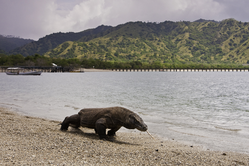
Komodo National Park
Indonesia · 8.6516° S, 119.5766° E · 2,193 km² · 92 km from Raba
Komodo National Park (Indonesian: Taman Nasional Komodo) is a national park in Indonesia within the Lesser Sunda Islands in the border region between the provinces of East Nusa Tenggara and West Nusa Tenggara. The park includes the three larger islands—Komodo, Padar and Rinca—and 26 smaller ones, with a total area of 1,733 km2 (669 sq mi), with 603 km2 (233 sq mi) of it land. The park was founded in 1980 to protect the Komodo dragon, the world's largest lizard. Later it was dedicated to protecting other species, including marine species. In 1991 the park was declared a UNESCO World Heritage Site and a Man and Biosphere Reserve. It is considered one of the world's 25 biodiversity hotspots.
Komodo National Park has been selected as one of the New 7 Wonders of Nature. The waters surrounding Komodo island contain rich marine biodiversity. Komodo island is also part of the Coral Triangle, which contains some of the richest marine biodiversity on Earth.
It is also a WWF Global 200 Marine Eco-region, a WWF/IUCN Centre of Plant Diversity, one of the world's Endemic Bird Areas and an ASEAN Heritage Park.
Adapted from Wikipedia: Komodo National Park (CC BY-SA 4.0).
Why Komodo National Park Is Listed
- (vii)
- Superlative natural phenomena or exceptional natural beauty.
- (x)
- The most important natural habitats for conserving biodiversity.
More about Komodo National Park
UNESCO's Description
These volcanic islands are inhabited by a population of around 5,700 giant lizards, whose appearance and aggressive behaviour have led to them being called 'Komodo dragons'. They exist nowhere else in the world and are of great interest to scientists studying the theory of evolution. The rugged hillsides of dry savannah and pockets of thorny green vegetation contrast starkly with the brilliant white sandy beaches and the blue waters surging over coral.
From the UNESCO World Heritage Centre (CC BY-SA IGO 3.0).
Geography and climate
The park comprises a coastal section of western Flores, the three larger islands of Komodo, Padar and Rinca, 26 smaller islands and the surrounding waters of the Sape Straights. The islands of the national park are of volcanic origin. The terrain is generally rugged, characterized by rounded hills, with altitudes up to 735 m (2,411 ft). The climate is one of the driest of Indonesia with annual rainfall of 800 to 1,000 mm (31 to 39 in). Temperatures in the dry season from May to October are around 40 °C (104 °F).
History
The island of Padar and part of Rinca were established as nature reserves in 1938.
Komodo Island was declared a nature reserve in 1965, and in January 1977 as a biosphere reserve under the UNESCO Man and Biosphere Reserve Programme.
In 1980 the islands of Komodo, Padar, Rinca and Gili Motong and the surrounding waters were declared a national park, for a total of 75,000 ha (190,000 acres; 750 km2).
In 1984 the national park was extended to 219,322 ha (541,960 acres) in order to include the marine area Mbeliling / Ngorang (31,000 ha or 77,000 acres), and Wae Wuul / Mburak Recreation Parks (3,000 ha or 7,400 acres) on mainland Flores. The marine zone covers 60% of the national park area.
Tourism
Scuba diving is popular because of the park's high marine biodiversity. Six well-known diving sites are Manta Alley, Crystal Rock and Castle Rock, Batu Bolong, Yellow Wall, the Cauldron and Tatawa Besar.
The development of ecotourism, largely marine-based, is the main strategy to make the park self-financing and generate sufficient revenue through entrance fees and tourism licenses to cover operational and managerial costs. To this end, a joint venture between TNC and a tourism operator were granted a tourism concession, that also entails extensive park management rights. This concession has generated an ongoing controversy.
Sections adapted from Wikipedia: Komodo National Park (CC BY-SA 4.0).
Key Facts
| Established | 1980 |
|---|---|
| Area | 17,332 km² |
Facts from Wikidata Q4520 (CC0).

Prambanan Temple
Indonesia · 7.7520° S, 110.4912° E · 13 km from Yogyakarta
Prambanan (Indonesian: Candi Prambanan, Javanese: Rara Jonggrang, Hanacaraka: ꦫꦫꦗꦺꦴꦁꦒꦿꦁ) is a 9th-century Hindu temple compound in the Special Region of Yogyakarta, in southern Java, Indonesia, dedicated to the Trimūrti, the expression of God as the Creator (Brahma), the Preserver (Vishnu), and the Destroyer (Shiva). The temple compound is located approximately 17 kilometres (11 mi) northeast of Yogyakarta on the boundary between Central Java and Yogyakarta provinces.
The temple compound, a UNESCO World Heritage Site, is the largest Hindu temple site in Indonesia and the second-largest in Southeast Asia after Angkor Wat. It is characterized by its tall pointed architecture, typical of Hindu architecture, and by the towering 47-metre-high (154 ft) central building inside a large complex of individual temples. The compounds originally consisted of 240 temple structures, which represented the grandeur of ancient Java's Hindu art and architecture, and it is also considered a masterpiece of the classical period in Indonesia.
Adapted from Wikipedia: Prambanan (CC BY-SA 4.0).
Why Prambanan Temple Is Listed
- (i)
- A masterpiece of human creative genius.
- (iv)
- An outstanding example of a type of building or landscape.
More about Prambanan Temple
UNESCO's Description
Built in the 10th century, this is the largest temple compound dedicated to Shiva in Indonesia. Rising above the centre of the last of these concentric squares are three temples decorated with reliefs illustrating the epic of the Ramayana , dedicated to the three great Hindu divinities (Shiva, Vishnu and Brahma) and three temples dedicated to the animals who serve them.
From the UNESCO World Heritage Centre (CC BY-SA IGO 3.0).
History
The Prambanan temple is the largest Hindu temple of ancient Java, and the first building was completed in the mid-9th century. It was likely started by Rakai Pikatan and inaugurated by his successor King Lokapala. Some historians that adhere to dual dynasty theory suggest that the construction of Prambanan probably was meant as the Hindu Sanjaya dynasty's answer to the Buddhist Sailendra dynasty's Borobudur and Sewu temples nearby, and was meant to mark the return of the Hindu Sanjaya dynasty to power in Central Java after almost a century of Buddhist Sailendra dynasty domination. Nevertheless, the construction of this massive Hindu temple signified a shift of the Mataram court's patronage, from Mahayana Buddhism to Shaivite Hinduism.
Sections adapted from Wikipedia: Prambanan (CC BY-SA 4.0).
Visiting Prambanan Temple
Prambanan is a complex of massive ancient Hindu temples (candi) in Central Java, Indonesia. It was built by the Mataram Kingdom, rulers of central Java and defeaters of the Sailendra Dynasty.
Travel notes adapted from Wikivoyage: Prambanan (CC BY-SA 4.0).

Ujung Kulon National Park
Indonesia · 6.7500° S, 105.3333° E · 785 km² · 115 km from Serang
Ujung Kulon National Park (Indonesian: Taman Nasional Ujung Kulon) is a national park at the westernmost tip of Java, located in Sumur District of Pandeglang Regency, part of Banten province in Indonesia. It once included the volcanic island group of Krakatoa in Lampung province, although current maps have suggested the Krakatoa island group as its own protected area, the Pulau Anak Krakatau Marine Nature Reserve.
The area has been declared a UNESCO World Heritage Site for "containing the largest remaining area of lowland rainforests in Java", and also for possessing the most threatened species of rhino, the Javan rhino. It was designated before its formation as a national park.
The park fully encompasses the Ujung Kulon peninsula, along with surrounding islands and the Gunung Honje mountain range.
Ujung Kulon itself means Western End or Point West in Banten Sundanese.
Adapted from Wikipedia: Ujung Kulon National Park (CC BY-SA 4.0).
Why Ujung Kulon National Park Is Listed
- (vii)
- Superlative natural phenomena or exceptional natural beauty.
- (x)
- The most important natural habitats for conserving biodiversity.
More about Ujung Kulon National Park
UNESCO's Description
This national park, located in the extreme south-western tip of Java on the Sunda shelf, includes the Ujung Kulon peninsula and several offshore islands and encompasses the natural reserve of Krakatoa. In addition to its natural beauty and geological interest – particularly for the study of inland volcanoes – it contains the largest remaining area of lowland rainforests in the Java plain. Several species of endangered plants and animals can be found there, the Javan rhinoceros being the most seriously under threat.
From the UNESCO World Heritage Centre (CC BY-SA IGO 3.0).
Geography
Ujung Kulon National Park covers an area of 1,056.95 km2 (408.09 sq mi), of which 443.37 km2 (171.19 sq mi) is marine.
Most of the park landmass lies on the mainland, specifically the Ujung Kulon Peninsula, with the highest elevation of 480 m (1,570 ft) at Mt. Payung in the southwest of the peninsula. The eastern area of the park is marked by the Honje mountain range, with several low-lying mountains and the highest peak at Mt. Honje at 620 m (2,030 ft).
History
The Ujung Kulon area was first introduced to the Western world by Dutch-German botanist, Franz W. Junghuhn in 1846, during one of his expeditions. Since then, scientists have started gaining interest in the peninsula's biological abundance. Several years later, this supposed first trip to Ujung Kulon was included in a scientific journal.
However there are not many written records regarding Ujung Kulon before the eruption of Mount Krakatoa in 1883.
Following the Krakatoa eruption and the ensuing tsunami, which was reported to be 15 meters high, many of the peninsula's settlements were destroyed and never completely rebuilt. The eruption also obliterated much of the local flora and fauna, leaving an average 30 cm (12 in) layer of volcanic ash across the area.
Sections adapted from Wikipedia: Ujung Kulon National Park (CC BY-SA 4.0).
Key Facts
| Established | 1980 |
|---|---|
| Area | 1,206 km² |
Facts from Wikidata Q4522 (CC0).

Sangiran
Indonesia · 7.4500° S, 110.8500° E · 56 km² · 13 km from Surakarta
Sangiran is an archaeological excavation site in Java in Indonesia. According to a UNESCO report (1995) "Sangiran is recognized by scientists to be one of the most important sites in the world for studying fossil man, ranking alongside Zhoukoudian (China), Willandra Lakes (Australia), Olduvai Gorge (Tanzania), and Sterkfontein (South Africa), and more fruitful in finds than any of these."
The area comprises about 56 km2 (7 km x 8 km). It is located in Central Java, about 15 kilometers north of Surakarta in the Solo River valley. Administratively, Sangiran area is divided between 2 regencies: Sragen (districts of Gemolong, Kalijambe, and Plupuh) and Karanganyar (district of Gondangrejo). An important feature of the site is the geology of the area. Originally a dome was created millions of years ago through tectonic uplifts. The dome was then eroded exposing beds within the dome which are rich in archeological records.
Adapted from Wikipedia: Sangiran (CC BY-SA 4.0).
Why Sangiran Is Listed
- (iii)
- A unique testimony to a cultural tradition or civilisation.
- (vi)
- A direct association with events, ideas or beliefs of universal significance.
More about Sangiran
UNESCO's Description
Excavations here from 1936 to 1941 led to the discovery of the first hominid fossil at this site. Later, 50 fossils of Meganthropus palaeo and Pithecanthropus erectus/Homo erectus were found – half of all the world's known hominid fossils. Inhabited for the past one and a half million years, Sangiran is one of the key sites for the understanding of human evolution.
From the UNESCO World Heritage Centre (CC BY-SA IGO 3.0).
History
1883: The Dutch paleoanthropologist Eugène Dubois undertook preliminary fieldwork at Sangiran. However, Dubois did not find many fossils of interest so he shifted his attention to Trinil in East Java where he found significant discoveries.
1934: The anthropologist Gustav Heinrich Ralph von Koenigswald started to examine the area. During excavations in the next years fossils of some of the first known human ancestors, Pithecanthropus erectus ("Java Man", now reclassified as part of the species Homo erectus), were found here. About 60 more human fossils, among them the enigmatic "Meganthropus", have since been found. Sangiran 2, for example, was discovered by von Koenigswald at the site.
Sections adapted from Wikipedia: Sangiran (CC BY-SA 4.0).
Visiting Sangiran
For solo travel, see Travelling alone.
Solo the short name for Surakarta, is a major city in Central Java. Together with Yogyakarta, these two great cultural centres are heirs of the Mataram kingdom that was split in 1755. Both centres are good bases for trips to nearby UNESCO World Heritage sites like the temple complexes of Borobudur and Prambanan.
Travel notes adapted from Wikivoyage: Solo (CC BY-SA 4.0).

Lorentz National Park
Indonesia · 4.7500° S, 137.8333° E · 23,500 km² · 107 km from Timika
Lorentz National Park is an Indonesian national park located in the provinces of Central Papua, Highland Papua and South Papua, in the southwest of western New Guinea. With an area of 25,056 km2 (9,674 mi2), it is the largest national park in Southeast Asia. In 1999 Lorentz was declared a World Heritage Site by UNESCO.
An outstanding example of the biodiversity of New Guinea, Lorentz is one of the most ecologically diverse national parks in the world. It is the only nature reserve in the Asia-Pacific region to contain a full altitudinal array of ecosystems ranging through marine areas, mangroves, tidal and freshwater swamp forest, lowland and montane rainforest, subalpine shrub and grassland, alpine tundra, and equatorial glaciers. At 4,884 metres (16,024 ft), Puncak Jaya (formerly Carstensz Pyramid) is the tallest mountain between the Himalayas and the Andes.
Birdlife International has called Lorentz Park "probably the single most important reserve in New Guinea".
Adapted from Wikipedia: Lorentz National Park (CC BY-SA 4.0).
Why Lorentz National Park Is Listed
- (viii)
- An outstanding example of major stages of the Earth's history.
- (ix)
- An outstanding example of ongoing ecological and biological processes.
- (x)
- The most important natural habitats for conserving biodiversity.
More about Lorentz National Park
UNESCO's Description
Lorentz National Park (2.35 million ha) is the largest protected area in South-East Asia. It is the only protected area in the world to incorporate a continuous, intact transect from snowcap to tropical marine environment, including extensive lowland wetlands. Located at the meeting-point of two colliding continental plates, the area has a complex geology with ongoing mountain formation as well as major sculpting by glaciation. The area also contains fossil sites which provide evidence of the evolution of life on New Guinea, a high level of endemism and the highest level of biodiversity in the region.
From the UNESCO World Heritage Centre (CC BY-SA IGO 3.0).
Key Facts
| Established | 1997 |
|---|---|
| Area | 25.1 km² |
Facts from Wikidata Q4516 (CC0).
Visiting Lorentz National Park
Lorentz National Park (Indonesian: Taman Nasional Lorentz) is a UNESCO World Heritage Site in southwestern and central Papua province of Indonesia, which is located on the western half of the island of New Guinea.
Travel notes adapted from Wikivoyage: Lorentz National Park (CC BY-SA 4.0).

Tropical Rainforest Heritage of Sumatra
Indonesia · 2.5000° S, 101.5000° E · 25,951 km² · 50 km from Sungaipenuh
The Tropical Rainforest Heritage of Sumatra site was inscribed as a UNESCO World Heritage Site in 2004. It comprises three Indonesian national parks on the island of Sumatra: Gunung Leuser National Park, Kerinci Seblat National Park and the Bukit Barisan Selatan National Park. The site is listed under Criteria vii - outstanding scenic beauty; ix- an outstanding example representing significant on-going ecological and biological processes; and x- contains the most important and significant natural habitats for in-situ conservation. The Tropical Rainforest Heritage of Sumatra has been placed on the Danger List since 2011 to help overcome threats posed by poaching, illegal logging, agricultural encroachment, and plans to build roads through the site.
Adapted from Wikipedia: Tropical Rainforest Heritage of Sumatra (CC BY-SA 4.0).
Why Tropical Rainforest Heritage of Sumatra Is Listed
- (vii)
- Superlative natural phenomena or exceptional natural beauty.
- (ix)
- An outstanding example of ongoing ecological and biological processes.
- (x)
- The most important natural habitats for conserving biodiversity.
More about Tropical Rainforest Heritage of Sumatra
UNESCO's Description
The 2.5 million hectare Tropical Rainforest Heritage of Sumatra site comprises three national parks: Gunung Leuser National Park, Kerinci Seblat National Park and Bukit Barisan Selatan National Park. The site holds the greatest potential for long-term conservation of the distinctive and diverse biota of Sumatra, including many endangered species. The protected area is home to an estimated 10,000 plant species, including 17 endemic genera; more than 200 mammal species; and some 580 bird species of which 465 are resident and 21 are endemic. Of the mammal species, 22 are Asian, not found elsewhere in the archipelago and 15 are confined to the Indonesian region, including the endemic Sumatran orang-utan. The site also provides biogeographic evidence of the evolution of the island.
From the UNESCO World Heritage Centre (CC BY-SA IGO 3.0).
Geography and climate
Gunung Leuser National Park in the north of the island is 150 km long, over 100 km wide and is mostly mountainous. 40% of the park is steep, and over 1,500 m. 12% of the park only, in the lower southern half, is below 600 meters but for 25 km runs down the coast. Eleven peaks are over 2,700 m and the highest point is Gunung Leuser reaching 3,466 metres. The area surrounding Gunung Leuser is known as the Leuser Ecosystem.
Kerinci Seblat National Park in the centre extends 350 km down the back of the Bukit Barisan, averaging 45 km width and 2000 m above sea level. The northern half has a lower eastern mountain range, between 800 and 1500 m. Three quarters of the park is steep. The highest point, and highest volcano in Indonesia, is the Mount Kerinci, standing at 3,805 m.
Location and size
The Tropical Rainforest Heritage of Sumatra consists of three national parks: Gunung Leuser National Park (GLNP) (8629.75 km2), Kerinci Seblat National Park (KSNP) (13,753.5 km2) and Bukit Barisan Selatan National Park (BBSNP) (3568 km2). The total area of the rainforest is 25,000 km2. The Tropical Rainforest Heritage of Sumatra was chosen because, first, it represents significant area of forests on the island of Sumatra, because of the biodiversity of lowland and mountain forest. This once vast island of tropical rainforest has been condensed to secluded areas in the space of 50 years.
Sections adapted from Wikipedia: Tropical Rainforest Heritage of Sumatra (CC BY-SA 4.0).
Key Facts
| Area | 25,000 km² |
|---|
Facts from Wikidata Q4521 (CC0).

Pegulingan Temple
Indonesia · 8.4150° S, 115.3178° E · 195 km² · 28 km from Denpasar
The cultural landscape of Bali consists of five rice terraces and their water temples that cover 19,500 ha. The temples are the focus of a cooperative water management system of canals and weirs, known as subak, that dates back to the 9th century. Included in the landscape is the 18th-century Royal Water Temple of Pura Taman Ayun, the largest and most impressive architectural edifice of its type on the island. The subak reflects the philosophical concept of Tri Hita Karana , which brings together the realms of the spirit, the human world and nature. This philosophy was born of the cultural exchange between Bali and India over the past 2,000 years and has shaped the landscape of Bali. The subak system of democratic and egalitarian farming practices has enabled the Balinese to become the most prolific rice growers in the archipelago despite the challenge of supporting a dense population.
Description from the UNESCO World Heritage Centre (CC BY-SA IGO 3.0).
Why Pegulingan Temple Is Listed
- (ii)
- An important interchange of human values.
- (iii)
- A unique testimony to a cultural tradition or civilisation.
- (v)
- An outstanding example of traditional human settlement or land use.
- (vi)
- A direct association with events, ideas or beliefs of universal significance.

Ombilin coal mine
Indonesia · 0.6833° S, 100.7670° E · 3 km² · 3 km from Sawahlunto
The Ombilin Coal Mine (formerly PT Tambang Batubara Ombilin (TBO)) is a coal mine near Sawahlunto, West Sumatra, Indonesia. It is located in a narrow valley along the Bukit Barisan mountains, among the Polan, Pari, and Mato hills, approximately 70 kilometres (43 mi) northeast of Padang. Coal was discovered in the mid-19th century by Willem Hendrik de Greve, and mining began in the area in 1876. The mine is the oldest coal mining site in Southeast Asia.
Adapted from Wikipedia: Ombilin Coal Mine (CC BY-SA 4.0).
Why Ombilin coal mine Is Listed
- (ii)
- An important interchange of human values.
- (iv)
- An outstanding example of a type of building or landscape.
More about Ombilin coal mine
UNESCO's Description
Built for the extraction, processing and transport of high-quality coal in an inaccessible region of Sumatra, this industrial site was developed by the Netherlands East Indies’ government in the globally important period of industrialisation from the late 19th to the beginning of the 20th century. The workforce was recruited from the local Minangkabau people and supplemented by Javanese and Chinese contract workers, and convict labourers from Dutch-controlled areas. It comprises the mining site and company town, coal storage facilities at the port of Emmahaven and the railway network linking the mines to the coastal facilities. The Ombilin Coal Mining Heritage was built as an integrated system that enabled the efficient deep-bore extraction, processing, transport and shipment of coal. It is also an outstanding testimony of exchange and fusion between local knowledge and practices and European technology.
From the UNESCO World Heritage Centre (CC BY-SA IGO 3.0).
History
Coal was discovered there by Dutch engineer Willem Hendrik de Greve in 1868. Mining started at the open-pit mine in 1892 after the construction of a railway. In the pre-independence period, coal production peaked in 1930, at more than 620,000 tonnes a year. Prisoners/Kettingganger (Dutch for people in chains) from Java and Sumatra who were transported to the mining site with their legs, hands, and necks chained up, were the main miners. Coal production fulfilled 90 percent of the Dutch East Indies’ energy needs.
In 1942–1945, the mine was controlled by Japan, and the mine declined. From 1945–1958, the mine was managed by the directorate of mining and in 1958–1968, by the bureau of state mining companies. In 1968, it became the Ombilin production unit of the state coal mining company.
Sections adapted from Wikipedia: Ombilin Coal Mine (CC BY-SA 4.0).

The Cosmological Axis of Yogyakarta and its Historic Landmarks
Indonesia · 7.8014° S, 110.3648° E · 3 km from Yogyakarta
The central axis of Yogyakarta was established in the 18th century by Sultan Mangkubumi, and has continued from that time as a centre of government and Javanese cultural traditions. The six kilometre north-south axis is positioned to link Mount Merapi and the Indian Ocean, with the Kraton (palace) at its centre, and key cultural monuments lining the axis to the north and south that are connected through rituals. It embodies key beliefs about the cosmos in Javanese culture, including the marking of the cycles of life.
Description from the UNESCO World Heritage Centre (CC BY-SA IGO 3.0).
Why The Cosmological Axis of Yogyakarta and its Historic Landmarks Is Listed
- (ii)
- An important interchange of human values.
- (iii)
- A unique testimony to a cultural tradition or civilisation.
World Heritage in Indonesia: Quick Answers
- How many UNESCO World Heritage Sites are in Indonesia?
- Indonesia has 10 World Heritage Sites: 6 cultural and 4 natural.
- What was the first World Heritage Site in Indonesia?
- Borobudur Temple Compounds, inscribed in 1991. The most recent is The Cosmological Axis of Yogyakarta and its Historic Landmarks, inscribed in 2023.
- What are the natural World Heritage Sites in Indonesia?
- Komodo National Park, Ujung Kulon National Park, Lorentz National Park, Tropical Rainforest Heritage of Sumatra.
- Are any World Heritage Sites in Indonesia in danger?
- Yes: Tropical Rainforest Heritage of Sumatra is on UNESCO's List of World Heritage in Danger.