
UNESCO World Heritage Sites in China
China has 60 sites on the UNESCO World Heritage List (41 cultural, 15 natural and 4 mixed), the first inscribed in 1987 (Imperial Palaces of the Ming and Qing Dynasties in Beijing and Shenyang). The map below plots every one of them alongside the rest of the List, and each site is written up in full further down the page.
- World Heritage Sites
- 60
- Cultural
- 41
- Natural and Mixed
- 19
- First Inscribed
- 1987
Map of World Heritage Sites in China
CulturalNaturalMixedIn DangerLarge dots are in China. Click a dot to read about the site.

Imperial Palaces of the Ming and Qing Dynasties in Beijing and Shenyang
China · 41.7942° N, 123.4469° E · 1 km² · 1 km from Shenyeng
Seat of supreme power for over five centuries (1416-1911), the Forbidden City in Beijing, with its landscaped gardens and many buildings (whose nearly 10,000 rooms contain furniture and works of art), constitutes a priceless testimony to Chinese civilization during the Ming and Qing dynasties. The Imperial Palace of the Qing Dynasty in Shenyang consists of 114 buildings constructed between 1625–26 and 1783. It contains an important library and testifies to the foundation of the last dynasty that ruled China, before it expanded its power to the centre of the country and moved the capital to Beijing. This palace then became auxiliary to the Imperial Palace in Beijing. This remarkable architectural edifice offers important historical testimony to the history of the Qing Dynasty and to the cultural traditions of the Manchu and other tribes in the north of China.
Description from the UNESCO World Heritage Centre (CC BY-SA IGO 3.0).
Why Imperial Palaces of the Ming and Qing Dynasties in Beijing and Shenyang Is Listed
- (i)
- A masterpiece of human creative genius.
- (ii)
- An important interchange of human values.
- (iii)
- A unique testimony to a cultural tradition or civilisation.
- (iv)
- An outstanding example of a type of building or landscape.

Mausoleum of the First Qin Emperor
China · 34.3817° N, 109.2539° E · 2 km² · 26 km from Weinan
The Mausoleum of Qin Shi Huang (Chinese: 秦始皇陵; pinyin: Qínshǐhuáng Líng) is a tomb complex constructed for Qin Shi Huang, the first emperor of the Chinese Qin dynasty. It is located in modern-day Lintong District in Xi'an, Shaanxi. It was constructed over 38 years from 246 to 208 BC, and is situated underneath a 76-metre-tall (249 ft) tomb mound shaped like a truncated pyramid. The layout of the mausoleum is modeled on the layout of Xianyang, the capital of the Qin dynasty, which was divided into inner and outer cities. The circumference of the inner city is 2.5 km (1.6 mi) and the outer is 6.3 km (3.9 mi). The tomb is located in the southwest of the inner city and faces east. The main tomb chamber housing the coffin and burial artifacts is the core of the architectural complex of the mausoleum.
The tomb itself has not yet been excavated. Archaeological explorations currently concentrate on various sites of the extensive necropolis surrounding the tomb, including the Terracotta Army to the east of the tomb mound. The Terracotta Army served as a garrison to the mausoleum and has yet to be completely excavated.
Adapted from Wikipedia: Mausoleum of Qin Shi Huang (CC BY-SA 4.0).
Why Mausoleum of the First Qin Emperor Is Listed
- (i)
- A masterpiece of human creative genius.
- (iii)
- A unique testimony to a cultural tradition or civilisation.
- (iv)
- An outstanding example of a type of building or landscape.
- (vi)
- A direct association with events, ideas or beliefs of universal significance.
More about Mausoleum of the First Qin Emperor
UNESCO's Description
No doubt thousands of statues still remain to be unearthed at this archaeological site, which was not discovered until 1974. Qin (d. 210 B.C.), the first unifier of China, is buried, surrounded by the famous terracotta warriors, at the centre of a complex designed to mirror the urban plan of the capital, Xianyan. The small figures are all different; with their horses, chariots and weapons, they are masterpieces of realism and also of great historical interest.
From the UNESCO World Heritage Centre (CC BY-SA IGO 3.0).
History
Work on the mausoleum began soon after Emperor Qin ascended the throne in 246 BCE when he was still aged 13, although its full-scale construction only started after he had conquered the six other major states and unified China in 221 BCE. It was completed 208 BCE, around 39 years after work started. Geographer Li Daoyuan, writing six centuries after the first emperor's death, recorded in Shui Jing Zhu that Mount Li was chosen as the location for his burial ground due to its auspicious geology: "famed for its jade mines, its northern side was rich in gold, and its southern side rich in beautiful jade; the first emperor, covetous of its fine reputation, therefore chose to be buried there".
In the ninth month, the First Emperor was interred at Mount Li.
Sections adapted from Wikipedia: Mausoleum of Qin Shi Huang (CC BY-SA 4.0).

Mogao Caves
China · 40.0372° N, 94.8042° E · 234 km² · 17 km from Dunhuang
The Mogao Caves, also known as the Thousand Buddha Grottoes or Caves of the Thousand Buddhas, form a system of 500 temples 25 km (16 mi) southeast of the center of Dunhuang, an oasis located at a religious and cultural crossroads on the Silk Road, in Gansu province, China. The caves may also be known as the Dunhuang Caves; however, this term is also used as a collective term to include other Buddhist cave sites in and around the Dunhuang area, such as the Western Thousand Buddha Caves, Eastern Thousand Buddha Caves, Yulin Caves, and Five Temple Caves. The caves contain some of the finest examples of Buddhist art spanning a period of 1,000 years. The first caves were dug out in 366 CE as places of Buddhist meditation and worship; later the caves became a place of pilgrimage, and caves continued to be built at the site until the 14th century. The Mogao Caves are the best known of the Chinese Buddhist grottoes and, along with Longmen Grottoes and Yungang Grottoes, are one of the three famous ancient Buddhist sculptural sites of China.
An important cache of documents was discovered in 1900 in the so-called "Library Cave", which had been walled-up in the 11th century.
Adapted from Wikipedia: Mogao Caves (CC BY-SA 4.0).
Why Mogao Caves Is Listed
- (i)
- A masterpiece of human creative genius.
- (ii)
- An important interchange of human values.
- (iii)
- A unique testimony to a cultural tradition or civilisation.
- (iv)
- An outstanding example of a type of building or landscape.
- (v)
- An outstanding example of traditional human settlement or land use.
- (vi)
- A direct association with events, ideas or beliefs of universal significance.
More about Mogao Caves
UNESCO's Description
Situated at a strategic point along the Silk Route, at the crossroads of trade as well as religious, cultural and intellectual influences, the 492 cells and cave sanctuaries in Mogao are famous for their statues and wall paintings, spanning 1,000 years of Buddhist art.
From the UNESCO World Heritage Centre (CC BY-SA IGO 3.0).
History
Dunhuang was established as a frontier garrison outpost by the Han dynasty Emperor Wudi to protect against the Xiongnu in 111 BC. It also became an important gateway to the West, a centre of commerce along the Silk Road, as well as a meeting place of various people and religions such as Buddhism. The Mogao Caves near Dunhuang were first constructed in the 4th century AD and were used as a site of Buddhist worship and pilgrimage. The caves contain over 400,000 square feet of frescoes and sculptures, making them one of the largest repositories of Buddhist art in the world.
The construction of the Mogao Caves is generally taken to have begun sometime in the fourth century AD, when Dunhuang was under control of the Former Liang dynasty.
Sections adapted from Wikipedia: Mogao Caves (CC BY-SA 4.0).

Mount Tai
China · 36.2667° N, 117.1000° E · 250 km² · 7 km from Taian
Mount Tai (Chinese: 泰山; pinyin: Tài Shān) or Taishan is a mountain of historical and cultural significance located north of the city of Tai'an. It is the highest point in Shandong province, China. The tallest peak is the Jade Emperor Peak (simplified Chinese: 玉皇顶; traditional Chinese: 玉皇頂; pinyin: Yùhuáng Dǐng), which is commonly reported as being 1,545 meters (5,069 ft) tall.
Mount Tai is known as the eastern mountain of the Sacred Mountains of China. It is associated with sunrise, birth, and renewal, and is often regarded the foremost of the five. Mount Tai has been a place of worship for at least 3,000 years and served as one of the most important ceremonial centers of China during large portions of this period. Because of its sacred importance and dramatic landscape, it was made a UNESCO World Heritage Site in 1987. It meets 7 of the 10 evaluation standards for World Heritage sites, and is listed as a World Heritage site that meets the most of the standards, along with the Tasmanian Wilderness World Heritage Area in Australia.
An earthquake or thunderstorm occurred around Mount Tai in 1831 BC or 1652 BC, also known as the Mount Tai earthquake.
Adapted from Wikipedia: Mount Tai (CC BY-SA 4.0).
Why Mount Tai Is Listed
- (i)
- A masterpiece of human creative genius.
- (ii)
- An important interchange of human values.
- (iii)
- A unique testimony to a cultural tradition or civilisation.
- (iv)
- An outstanding example of a type of building or landscape.
- (v)
- An outstanding example of traditional human settlement or land use.
- (vi)
- A direct association with events, ideas or beliefs of universal significance.
- (vii)
- Superlative natural phenomena or exceptional natural beauty.
More about Mount Tai
UNESCO's Description
The sacred Mount Tai ('shan' means 'mountain') was the object of an imperial cult for nearly 2,000 years, and the artistic masterpieces found there are in perfect harmony with the natural landscape. It has always been a source of inspiration for Chinese artists and scholars and symbolizes ancient Chinese civilizations and beliefs.
From the UNESCO World Heritage Centre (CC BY-SA IGO 3.0).
Climate
The area falls within the warm continental monsoon climate (Koppen Dwb). The average annual temperature is 6.2°C, and it is relatively warm from July to August.
Vegetation covers 79.9% of the area, which is densely wooded, but information about its composition is lacking. The flora is diverse and known to comprise 989 species, of which 433 species are woody and the rest herbaceous. Medicinal plants total 462 species and include multiflower knotweed, Cannabis, Taishan ginseng, Chinese gromwell and sealwort, which are renowned throughout the country.
History
Traces of human presence at Mount Tai date back to the Paleolithic period. Evidence of human settlement of the area can be proven from the Neolithic period onwards. During this time, two cultures had emerged near the mountain, the Dawenkou culture to the south and the Longshan culture to the north.
During the Xia dynasty (c. 2070–1600 BC) the mountain was known as Mount Dai (Chinese: 岱山; pinyin: Dài Shān) and lay within the borders of Qingzhou, one of the Nine Provinces of ancient China.
Religious worship of Mount Tai has a tradition dating back 3,000 years, from the time of the Shang (c. 1600–1046 BC) to the Qing dynasty (1644–1912). Over time, this worship evolved into the Feng and Shan sacrifices or Fengshan.
Location
Mount Tai is located in western Shandong, just north of the city of Tai'an and to the south of the provincial capital Jinan. It extends from 150–1,545 meters (492–5,069 ft) above sea level and covers an area of 426 km2 (164 sq mi) at its base. The Jade Emperor Peak, which rises 1,532.7 meters (5,029 ft) above sea level, is located at 36° 16′N and 117° 6′E.
Mount Tai was formed in the middle of the Cenozoic about 30 million years ago. The stratum of Mount Tai is ancient, mainly composed of several ancient rocks such as mixed rock, mixed granite and various gneiss.
The government prevents exploration of the caves, for they are unassessed and potentially dangerous.
The Luxi region (including Mount Tai) used to be a huge subsiding belt or sea canal.
Sections adapted from Wikipedia: Mount Tai (CC BY-SA 4.0).

The Great Wall
China · 40.4167° N, 116.0833° E · 22 km² · 23 km from Changping
In c. 220 B.C., under Qin Shi Huang, sections of earlier fortifications were joined together to form a united defence system against invasions from the north. Construction continued up to the Ming dynasty (1368–1644), when the Great Wall became the world's largest military structure. Its historic and strategic importance is matched only by its architectural significance.
Description from the UNESCO World Heritage Centre (CC BY-SA IGO 3.0).
Why The Great Wall Is Listed
- (i)
- A masterpiece of human creative genius.
- (ii)
- An important interchange of human values.
- (iii)
- A unique testimony to a cultural tradition or civilisation.
- (iv)
- An outstanding example of a type of building or landscape.
- (vi)
- A direct association with events, ideas or beliefs of universal significance.

Zhoukoudian site
China · 39.6890° N, 115.9248° E · 5 km² · 20 km from Zhuozhou
Zhoukoudian Peking Man Site (周口店北京人遗址), also romanized as Choukoutien, is a cave system in suburban Fangshan District, Beijing. It has yielded many archaeological discoveries, including one of the first specimens of Homo erectus (Homo erectus pekinensis), dubbed Peking Man, and a fine assemblage of bones of the giant short-faced hyena Pachycrocuta brevirostris.
Due to differing interpretations of the evidence, proposed dates for when Peking Man inhabited this site vary greatly, including: 700,000–200,000 years ago, 670,000–470,000 years ago, or no earlier than 530,000 years ago.
The Peking Man Site was first discovered by Johan Gunnar Andersson in 1921, and was first excavated by Otto Zdansky in 1921 and 1923, unearthing two human teeth. These were later identified by Davidson Black as belonging to a previously unknown species, and extensive excavations followed. Fissures in the limestone-containing middle Pleistocene deposits have yielded the remains of about 45 individuals, as well as animal remains, and stone flake and chopping tools.
Adapted from Wikipedia: Zhoukoudian Peking Man Site (CC BY-SA 4.0).
Why Zhoukoudian site Is Listed
- (iii)
- A unique testimony to a cultural tradition or civilisation.
- (vi)
- A direct association with events, ideas or beliefs of universal significance.
More about Zhoukoudian site
UNESCO's Description
Scientific work at the site, which lies 42 km south-west of Beijing, is still underway. So far, it has led to the discovery of the remains of Sinanthropus pekinensis , who lived in the Middle Pleistocene, along with various objects, and remains of Homo sapiens sapiens dating as far back as 18,000–11,000 B.C. The site is not only an exceptional reminder of the prehistorical human societies of the Asian continent, but also illustrates the process of evolution.
From the UNESCO World Heritage Centre (CC BY-SA IGO 3.0).
Excavation history
Swedish geologist Johan Gunnar Andersson first started his explorations of the region in 1918 at an area called Chicken-bone Hill by locals who had misidentified the rodent fossils that were found in abundance there, but it was not until 1921 that he and American palaeontologist Walter W. Granger were led to the site known as Dragon Bone Hill by local quarry men. Noticing some white quartz that was foreign to the area, he immediately realised that this would be a good place to search for the remains of primitive man.
Excavations were undertaken by Andersson's assistant, Austrian palaeontologist Otto Zdansky in 1921 and 1923, unearthing a great deal of material that was sent back to Uppsala University in Sweden for further analysis.
Sections adapted from Wikipedia: Zhoukoudian Peking Man Site (CC BY-SA 4.0).

Huangshan
China · 30.1250° N, 118.1667° E · 161 km² · 99 km from Tongling
Huangshan (simplified Chinese: 黄山; traditional Chinese: 黃山), literally meaning the Yellow Mountain(s), is a mountain range in southern Anhui province in eastern China. It was originally called "Yishan", and it was renamed because of a legend that the Yellow Emperor once made alchemy here. Vegetation on the range is thickest below 1,100 meters (3,600 ft), with trees growing up to the treeline at 1,800 meters (5,900 ft).
The area is well known for its scenery, sunsets, peculiarly shaped granite peaks, Huangshan pine trees, hot springs, winter snow, and views of the clouds from above. Huangshan is a frequent subject of traditional Chinese paintings and literature, as well as modern photography. It is a UNESCO World Heritage Site and one of China's major tourist destinations.
Adapted from Wikipedia: Huangshan (CC BY-SA 4.0).
Why Huangshan Is Listed
- (ii)
- An important interchange of human values.
- (vii)
- Superlative natural phenomena or exceptional natural beauty.
- (x)
- The most important natural habitats for conserving biodiversity.
More about Huangshan
UNESCO's Description
Huangshan, known as 'the loveliest mountain of China', was acclaimed through art and literature during a good part of Chinese history (e.g. the Shanshui 'mountain and water' style of the mid-16th century). Today it holds the same fascination for visitors, poets, painters and photographers who come on pilgrimage to the site, which is renowned for its magnificent scenery made up of many granite peaks and rocks emerging out of a sea of clouds.
From the UNESCO World Heritage Centre (CC BY-SA IGO 3.0).
Climate
Huangshan has a humid continental climate (Köppen Climate Classification Dfb) or a subtropical highland climate (Cfb) depending on the isotherm used. Its elevation makes it colder and wetter than the rest of Anhui.
History
Huangshan was formed approximately 100 million years ago and gained its unique rock formations in the Quaternary Glaciation.
During the Qin dynasty, Huangshan was known as Yishan (Mount Yi). In 747 AD, its name was changed to Huangshan (Mount Huang) by imperial decree; the name is commonly thought to have been coined in honor of Huang Di (the Yellow Emperor), a legendary Chinese emperor and the mythological ancestor of the Han Chinese. One legend states that Huangshan was the location from which the Yellow Emperor ascended to Heaven. Another legend states that the Yellow Emperor "cultivated moral character and refined Pills of Immortality in the mountains, and in so doing gave the mountains his name. The first use of this name "Huangshan" often is attributed to Chinese poet Li Bai.
Physical description
The Huangshan mountain range has many peaks, some more than 1,000 meters (3,250 feet) high. The three tallest and best-known peaks are Lotus Peak (Lianhua Feng, 1,864 m), Bright Peak (Guangming Ding, 1,860 m) and Celestial Peak (Tiandu Feng, literally Capital of Heaven Peak, 1,829 m). The World Heritage Site covers a core area of 154 square kilometres and a buffer zone of 142 square kilometres. The mountains were formed in the Mesozoic, approximately 100 million years ago, when an ancient sea disappeared due to uplift. Later, in the Quaternary Period, the landscape was shaped by the influence of glaciers.
The vegetation of the area varies with elevation. Mesic forests cover the landscape below 1,100 meters. Deciduous forest stretches from 1,100 meters up to the tree line at 1,800 meters.
Tourism
Having at least 140 sections open to visitors, Huangshan is a major tourist destination in China. Huangshan City changed its name from Tunxi (屯溪) in 1987 in order to promote Huangshan tourism. In 2007, more than 1.5 million tourists visited the mountain. The city is linked by rail and by air to Shanghai, and also is accessible from cities such as Hangzhou, Zhejiang and Wuhu, Anhui. Buses connect Huangshan City to the base of the mountain, where visitors can take a cable car or hike to the summit.
There are more than 50 kilometers of footpaths providing access to scenic areas for visitors and staff of the facilities.
Sections adapted from Wikipedia: Huangshan (CC BY-SA 4.0).
Visiting Huangshan
Huangshan (黄山; Huángshān; lit.: Yellow Mountain) is in Anhui Province in China, toward the southern end near the border with Zhejiang. It is on the UNESCO World Heritage List. There is also a Huangshan city to the south and a Huangshan district to the north.
Travel notes adapted from Wikivoyage: Huangshan (CC BY-SA 4.0).

Jiuzhaigou Valley
China · 33.2000° N, 103.9000° E · 720 km² · 138 km from Minxian
Jiuzhaigou ([tɕjòʊ.ʈʂâɪ.kóʊ] ; Chinese: 九寨沟; pinyin: Jiǔzhàigōu) is a nature reserve and national park located in the north of Sichuan Province in southwestern China. A long valley running north to south, Jiuzhaigou was inscribed by UNESCO as a World Heritage Site in 1992 and a World Biosphere Reserve in 1997. It belongs to the category V (Protected Landscape) in the IUCN system of protected area categorization.
The Jiuzhaigou valley is part of the Min Mountains on the edge of the Tibetan Plateau and stretches over 72,000 hectares (180,000 acres). It has an altitude of over 4800 meters and is composed of a series of diverse forest ecosystems. It is known for its many multi-level waterfalls, colorful lakes, and snow-capped peaks. Its elevation ranges from 2,000 to 4,500 metres (6,600 to 14,800 ft). The Jiuzhaigou area borders the Minshan Garna Peak in the south, and the Huanglong Scenic Area is to Jiuzhaigou's north. It originates from the Baishui River area, one of the headwaters of the Jialing River and a part of the Yangtze River system.
Adapted from Wikipedia: Jiuzhaigou (CC BY-SA 4.0).
Why Jiuzhaigou Valley Is Listed
- (vii)
- Superlative natural phenomena or exceptional natural beauty.
More about Jiuzhaigou Valley
UNESCO's Description
Stretching over 72,000 ha in the northern part of Sichuan Province, the jagged Jiuzhaigou valley reaches a height of more than 4,800 m, thus comprising a series of diverse forest ecosystems. Its superb landscapes are particularly interesting for their series of narrow conic karst land forms and spectacular waterfalls. Some 140 bird species also inhabit the valley, as well as a number of endangered plant and animal species, including the giant panda and the Sichuan takin.
From the UNESCO World Heritage Centre (CC BY-SA IGO 3.0).
Geography and climate
Jiuzhaigou lies at the southern end of the Minshan mountain range, 330 km (205 mi) north of the provincial capital of Chengdu. It is part of the Jiuzhaigou County (formerly Nanping County) in the Aba Tibetan Qiang Autonomous Prefecture of northwestern Sichuan province, near the Gansu border.
The valley covers 720 km2 (278 sq mi), with buffer zones covering an additional 600 km2 (232 sq mi). Its elevation, depending on the area considered, ranges from 1,998 to 2,140 m (at the mouth of Shuzheng Gully) to 4,558-4,764 m (on Mount Ganzigonggai at the top of Zechawa Gully).
The climate is subtropical to temperate monsoon with a mean annual temperature of 7.8 °C, with means of −3.7 °C in January and 16.8 °C in July. Total annual rainfall is 761 mm but in the cloud forest it is at least 1,000 mm.
Geology and hydrology
Jiuzhaigou's landscape is made up of high-altitude karsts shaped by glacial, hydrological and tectonic activity. It lies on major faults on the diverging belt between the Qinghai-Tibet Plate and the Yangtze Plate, and earthquakes have also shaped the landscape. The rock strata are mostly made up of carbonate rocks such dolomite and tufa, as well as some sandstone and shales.
The region contains a large amount of tuff, which is a type of limestone formed by the rapid precipitation of calcium carbonate in freshwater. It falls on rocks, lake beds, and even fallen trees in the water, sometimes accumulating into terraces, shoals, and dam barriers in the lake.
Ecology
Jiuzhaigou's ecosystem is classified as temperate broad-leaf forest and woodlands, with mixed mountain and highland systems. Nearly 300 km2 (116 sq mi) of the core scenic area are covered by virgin mixed forests. Those forests take on attractive (vibrant) yellow, orange and red hues in the autumn, making that season a popular one for visitors. They are home to a number of plant species of interest, such as endemic varieties of rhododendron and bamboo.
Local fauna includes the endangered giant panda and golden snub-nosed monkey. Both populations are very small (fewer than 20 individuals for the pandas) and isolated. Their survival is in question in a valley subject to increasing tourism. It is one of only three known locations for the threatened Duke of Bedford's vole.
History
Jiuzhaigou (literally "Nine Settlement Valley") takes its name from the nine Tibetan settlements along its length.
The remote region was inhabited by various Tibetan and Qiang peoples for centuries. Until 1975 this inaccessible area was little known. In 1975, famous forestry scientist Wu Zhonglun conducted a comprehensive survey of Jiuzhaigou. He was deeply moved, saying "I have visited several countries in Europe and America, but I have never seen such breathtaking natural beauty. It must be well protected."
Sections adapted from Wikipedia: Jiuzhaigou (CC BY-SA 4.0).
Key Facts
| Established | 1978 |
|---|---|
| Area | 720 km² |
Facts from Wikidata Q4111 (CC0).
Visiting Jiuzhaigou Valley
Jiuzhaigou (Chinese: 九寨沟 Jiǔzhàigōu, Tibetan: གཟི་རྩ་སྡེ་དགུ།) is a nature reserve in the north of Sichuan province in southwestern China. It is officially known as Jiuzhai Valley in English. It is known as the habitat of giant pandas and for its many multi-level waterfalls and colorful lakes. It was declared a UNESCO World Heritage Site in 1992.
After closing for two years due to a 7.0 magnitude earthquake in 2017, the park reopened to visitors in late 2019.
Travel notes adapted from Wikivoyage: Jiuzhaigou Nature Reserve (CC BY-SA 4.0).

Huanglong
China · 32.7408° N, 103.8311° E · 600 km²
Huanglong (simplified Chinese: 黄龙; traditional Chinese: 黃龍; pinyin: Huánglóng; lit. 'yellow dragon') is a scenic and historic interest area in the northwest part of Sichuan, China. It is located in the southern part of the Minshan mountain range, 370 kilometres (230 mi) north-northwest of the capital Chengdu. This area is known for its colorful travertine pools formed by calcite deposits, especially in Huanglonggou (Yellow Dragon Gully), as well as diverse forest ecosystems, snow-capped peaks, waterfalls and hot springs. Huanglong is also home to many endangered species including the giant panda and the Sichuan golden snub-nosed monkey. In addition, a large population of the endemic orchid species Cypripedium plectrochilum was discovered at the site. Huanglong was declared a World Heritage Site by UNESCO in 1992 because of its outstanding travertine formations, waterfalls and limestone formations as well as its travertine terraces and lakes rating among the three most outstanding examples in the world.
Adapted from Wikipedia: Huanglong Scenic and Historic Interest Area (CC BY-SA 4.0).
Why Huanglong Is Listed
- (vii)
- Superlative natural phenomena or exceptional natural beauty.
More about Huanglong
UNESCO's Description
Situated in the north-west of Sichuan Province, the Huanglong valley is made up of snow-capped peaks and the easternmost of all the Chinese glaciers. In addition to its mountain landscape, diverse forest ecosystems can be found, as well as spectacular limestone formations, waterfalls and hot springs. The area also has a population of endangered animals, including the giant panda and the Sichuan golden snub-nosed monkey.
From the UNESCO World Heritage Centre (CC BY-SA IGO 3.0).
Description
Danyun Gorge (Chinese: 丹云峽; lit. 'red cloud gorge'): A canyon more than 1,000 meters in depth. The snow melt from the nearby Mount Xuebaoding travels through this canyon, providing much of the water for the region.
Xueshan Ridge (雪山梁; 'snow mountain ridge') – 4,007 m (13,146 ft), the highest point on the road from Jiuhuang Airport to Huanglong Valley.
The total length of the travertine in Huanglong Valley is 3.6 km and it is thought to look like a huge golden dragon wheeling through the snow-capped mountains of the valley. The main landscapes are travertine banks, colorful ponds and travertine waterfalls and caves.
Sections adapted from Wikipedia: Huanglong Scenic and Historic Interest Area (CC BY-SA 4.0).

Wulingyuan
China · 29.3456° N, 110.4667° E · 264 km² · 123 km from Changde
Wulingyuan ([ù.lǐŋ.ɥɛ̌n], Chinese: 武陵源) is a scenic and historical site in the Wulingyuan District of South Central China's Hunan Province. It is noted for more than 3,000 quartzite sandstone pillars and peaks across most of the site, many over 200 metres (660 ft) in height, along with many ravines and gorges with picturesque streams, pools, lakes, rivers, and waterfalls. It features 40 caves, many with large calcite deposits and a natural bridge named Tianqiaoshengkong (meaning 'bridge across the sky'), which is one of the highest natural bridges in the world. The site also provides habitat for many vulnerable species, including the dhole, Asiatic black bear, and Chinese water deer.
The site is situated in Zhangjiajie City and lies about 270 kilometres (170 mi) to the northwest of Changsha, the capital of Hunan Province. The park covers an area of 690 square kilometers (266 square miles). Wulingyuan forms part of the Wuling Mountain Range. The scenic area consists of four national parks, which are the Zhangjiajie National Forest Park, Suoxi Valley Nature Reserve, Tianzi Mountain Nature Reserve, and the recently added Yangjiajie Scenic Area.
Adapted from Wikipedia: Wulingyuan (CC BY-SA 4.0).
Why Wulingyuan Is Listed
- (vii)
- Superlative natural phenomena or exceptional natural beauty.
More about Wulingyuan
UNESCO's Description
A spectacular area stretching over more than 26,000 ha in China's Hunan Province, the site is dominated by more than 3,000 narrow sandstone pillars and peaks, many over 200 m high. Between the peaks lie ravines and gorges with streams, pools and waterfalls, some 40 caves, and two large natural bridges. In addition to the striking beauty of the landscape, the region is also noted for the fact that it is home to a number of endangered plant and animal species.
From the UNESCO World Heritage Centre (CC BY-SA IGO 3.0).
Geology
The quartzite sandstone pillars and the surrounding regions were formed during the Devonian period (400 to 350 million years ago) from a combination of tectonic uplift and water erosion.
The highest area in the park is Huang Shi Zhai (黃石寨). It reaches a height of 3,450 feet (1,050 m) and is accessible via cable car or a set of stairs. Another cliff can be accessed by the 326 m (1,070 ft) Bailong Elevator.
Sections adapted from Wikipedia: Wulingyuan (CC BY-SA 4.0).
Ancient Building Complex in the Wudang Mountains
China · 32.4448° N, 111.0583° E · 1 km² · 30 km from Shiyan
The palaces and temples which form the nucleus of this group of secular and religious buildings exemplify the architectural and artistic achievements of China's Yuan, Ming and Qing dynasties. Situated in the scenic valleys and on the slopes of the Wudang mountains in Hubei Province, the site, which was built as an organized complex during the Ming dynasty (14th–17th centuries), contains Taoist buildings from as early as the 7th century. It represents the highest standards of Chinese art and architecture over a period of nearly 1,000 years.
Description from the UNESCO World Heritage Centre (CC BY-SA IGO 3.0).
Why Ancient Building Complex in the Wudang Mountains Is Listed
- (i)
- A masterpiece of human creative genius.
- (ii)
- An important interchange of human values.
- (vi)
- A direct association with events, ideas or beliefs of universal significance.

Chengde Mountain Resort and its outlying temples
China · 40.9875° N, 117.9375° E · 6 km² · 3 km from Chengde
Chengde Mountain Resort (Chinese: 承德避暑山庄; Manchu: ᡥᠠᠯᡥᡡᠨ ᠪᡝ ᠵᠠᡳ᠌ᠯᠠᡵᠠ ᡤᡠᡵᡠᠩ Halhūn be jailara gurung) is a large complex of imperial palaces and gardens situated in the Shuangqiao District of Chengde in northeastern Hebei province, northern China, about 225 kilometres (140 mi) northeast of China's capital Beijing. This resort was frequently used as a summer vacation place before the Kuomintang Republic of China. Because of its vast and rich collection of Chinese landscapes and architecture, Chengde Mountain Resort in many ways is a culmination of all the variety of gardens, pagodas, temples and palaces from various regions of China. In 1994, The Mountain Resort was awarded World Heritage Site status.
Chengde is one of China's four famous gardens, national relic protection unit and Class 5A Tourist Attractions in China.
Adapted from Wikipedia: Chengde Mountain Resort (CC BY-SA 4.0).
Why Chengde Mountain Resort and its outlying temples Is Listed
- (ii)
- An important interchange of human values.
- (iv)
- An outstanding example of a type of building or landscape.
More about Chengde Mountain Resort and its outlying temples
UNESCO's Description
The Mountain Resort (the Qing dynasty's summer palace), in Hebei Province, was built between 1703 and 1792. It is a vast complex of palaces and administrative and ceremonial buildings. Temples of various architectural styles and imperial gardens blend harmoniously into a landscape of lakes, pastureland and forests. In addition to its aesthetic interest, the Mountain Resort is a rare historic vestige of the final development of feudal society in China.
From the UNESCO World Heritage Centre (CC BY-SA IGO 3.0).
Climate
Chengde Mountain Resort is located in the transition zone from warm temperate zone to cold temperate zone. It has semi - temperate, semi - arid continental monsoon climate. It has a large difference in temperature between day and night. In winter, it is cold and has little snow. It has many thundershowers in summer, leading to few hot periods. Chengde Mountain Resort is suitable for traveling in every season, but best from April to October.
History
Built between 1703 and 1792 by Chinese architects, the Mountain Resort took 89 years to complete. It covers a total area of 5.6 km2 (2.2 sq mi), almost half of Chengde's urban area. It is a vast complex of palaces and administrative and ceremonial buildings. Temples of various Chinese architectural styles and gardens blend harmoniously into a landscape of lakes, pastureland and forests.
The rulers of the Qing regime often spent several months a year here to escape the summer heat in the capital city of Beijing and the palace zone in the southern part of the resort was therefore designed to resemble the Forbidden City in Beijing.
Sections adapted from Wikipedia: Chengde Mountain Resort (CC BY-SA 4.0).

Temple and Cemetery of Confucius and the Kong Family Mansion in Qufu
China · 35.5965° N, 116.9844° E · 2 km² · 45 km from Jining
Temple and Cemetery of Confucius and the Kong Family Mansion in Qufu, Shandong Province of China, include Temple of Confucius, Cemetery of Confucius and the Kong Family Mansion.
Since 1994, the Temple of Confucius (Chinese: 孔庙; pinyin: Kǒng Miào) has been part of the UNESCO World Heritage Site "Temple and Cemetery of Confucius and the Kong Family Mansion in Qufu". The two other parts of the site are the nearby Kong Family Mansion (Chinese: 孔府; pinyin: Kǒng Fǔ), where the main-line descendants of Confucius lived, and the Cemetery of Confucius (Chinese: 孔林; pinyin: Kǒng Lín) a couple kilometers to the north, where Confucius and many of his descendants have been buried. Those three sites are collectively known in Qufu as San Kong (三孔), i.e. "The Three Confucian [sites]".
Adapted from Wikipedia: Temple and Cemetery of Confucius and the Kong Family Mansion in Qufu (CC BY-SA 4.0).
Why Temple and Cemetery of Confucius and the Kong Family Mansion in Qufu Is Listed
- (i)
- A masterpiece of human creative genius.
- (iv)
- An outstanding example of a type of building or landscape.
- (vi)
- A direct association with events, ideas or beliefs of universal significance.
More about Temple and Cemetery of Confucius and the Kong Family Mansion in Qufu
UNESCO's Description
The temple, cemetery and family mansion of Confucius, the great philosopher, politician and educator of the 6th–5th centuries B.C., are located at Qufu, in Shandong Province. Built to commemorate him in 478 B.C., the temple has been destroyed and reconstructed over the centuries; today it comprises more than 100 buildings. The cemetery contains Confucius' tomb and the remains of more than 100,000 of his descendants. The small house of the Kong family developed into a gigantic aristocratic residence, of which 152 buildings remain. The Qufu complex of monuments has retained its outstanding artistic and historic character due to the devotion of successive Chinese emperors over more than 2,000 years.
From the UNESCO World Heritage Centre (CC BY-SA IGO 3.0).
Key Facts
| Area | 1.8 km² |
|---|
Facts from Wikidata Q1038473 (CC0).

World Heritage Sites in Tibet
China · 29.6579° N, 91.1172° E · 1 km² · 2 km from Lhasa
The Potala Palace, winter palace of the Dalai Lama since the 7th century, symbolizes Tibetan Buddhism and its central role in the traditional administration of Tibet. The complex, comprising the White and Red Palaces with their ancillary buildings, is built on Red Mountain in the centre of Lhasa Valley, at an altitude of 3,700m. Also founded in the 7th century, the Jokhang Temple Monastery is an exceptional Buddhist religious complex. Norbulingka, the Dalai Lama's former summer palace, constructed in the 18th century, is a masterpiece of Tibetan art. The beauty and originality of the architecture of these three sites, their rich ornamentation and harmonious integration in a striking landscape, add to their historic and religious interest.
Description from the UNESCO World Heritage Centre (CC BY-SA IGO 3.0).
Why World Heritage Sites in Tibet Is Listed
- (i)
- A masterpiece of human creative genius.
- (iv)
- An outstanding example of a type of building or landscape.
- (vi)
- A direct association with events, ideas or beliefs of universal significance.

Lushan Quaternary Glaciation National Geopark
China · 29.5667° N, 115.9667° E · 302 km² · 18 km from Jiujiang
Lushan Geopark (庐山世界地质公园) is located in the region around Mount Lu, Jiujiang. The protected area of 500 square kilometres (190 mi2) extends from the Yangtze River to the Poyang Lake basin.
Adapted from Wikipedia: Lushan Geopark (CC BY-SA 4.0).
Why Lushan Quaternary Glaciation National Geopark Is Listed
- (ii)
- An important interchange of human values.
- (iii)
- A unique testimony to a cultural tradition or civilisation.
- (iv)
- An outstanding example of a type of building or landscape.
- (vi)
- A direct association with events, ideas or beliefs of universal significance.
More about Lushan Quaternary Glaciation National Geopark
UNESCO's Description
Mount Lushan, in Jiangxi, is one of the spiritual centres of Chinese civilization. Buddhist and Taoist temples, along with landmarks of Confucianism, where the most eminent masters taught, blend effortlessly into a strikingly beautiful landscape which has inspired countless artists who developed the aesthetic approach to nature found in Chinese culture.
From the UNESCO World Heritage Centre (CC BY-SA IGO 3.0).

Mount Emei Scenic Area, including Leshan Giant Buddha Scenic Area
China · 29.5449° N, 103.7692° E · 154 km² · 5 km from Leshan
The first Buddhist temple in China was built here in Sichuan Province in the 1st century A.D. in the beautiful surroundings of the summit Mount Emei. The addition of other temples turned the site into one of Buddhism's holiest sites. Over the centuries, the cultural treasures grew in number. The most remarkable is the Giant Buddha of Leshan, carved out of a hillside in the 8th century and looking down on the confluence of three rivers. At 71 m high, it is the largest Buddha in the world. Mount Emei is also notable for its exceptionally diverse vegetation, ranging from subtropical to subalpine pine forests. Some of the trees there are more than 1,000 years old.
Description from the UNESCO World Heritage Centre (CC BY-SA IGO 3.0).
Why Mount Emei Scenic Area, including Leshan Giant Buddha Scenic Area Is Listed
- (iv)
- An outstanding example of a type of building or landscape.
- (vi)
- A direct association with events, ideas or beliefs of universal significance.
- (x)
- The most important natural habitats for conserving biodiversity.

Ancient City of Ping Yao
China · 37.2014° N, 112.1544° E · 2 km² · 29 km from Jiexiu
Ping Yao is an exceptionally well-preserved example of a traditional Han Chinese city, founded in the 14th century. Its urban fabric shows the evolution of architectural styles and town planning in Imperial China over five centuries. Of special interest are the imposing buildings associated with banking, for which Ping Yao was the major centre for the whole of China in the 19th and early 20th centuries.
Description from the UNESCO World Heritage Centre (CC BY-SA IGO 3.0).
Why Ancient City of Ping Yao Is Listed
- (ii)
- An important interchange of human values.
- (iii)
- A unique testimony to a cultural tradition or civilisation.
- (iv)
- An outstanding example of a type of building or landscape.

Classical Gardens of Suzhou
China · 31.3267° N, 120.6256° E · 3 km from Suzhou
The Classical Gardens of Suzhou (traditional Chinese: 蘇州園林; simplified Chinese: 苏州园林; pinyin: Sūzhōu yuánlín; Suzhounese (Wugniu): sou1-tseu1 yoe2-lin2) are a group of gardens in the city of Suzhou, in Jiangsu, China, that are on the UNESCO World Heritage List.
Spanning a period of almost one thousand years, from the Northern Song to the late Qing dynasties (11th-19th century), these gardens, most of them built by scholars, standardized many of the key features of classical Chinese garden design with constructed landscapes mimicking natural scenery of rocks, hills and rivers with strategically located pavilions and pagodas.
The elegant aesthetics and subtlety of these scholars' gardens and their delicate style and features are often imitated by various gardens in other parts of China, including the various Imperial Gardens, such as those in the Chengde Mountain Resort. According to UNESCO, the gardens of Suzhou "represent the development of Chinese landscape garden design over more than two thousand years", and they are the "most refined form" of garden art.
These landscape gardens flourished in the mid-Ming to early-Qing dynasties, resulting in as much as 200 private gardens.
Adapted from Wikipedia: Classical Gardens of Suzhou (CC BY-SA 4.0).
Why Classical Gardens of Suzhou Is Listed
- (i)
- A masterpiece of human creative genius.
- (ii)
- An important interchange of human values.
- (iii)
- A unique testimony to a cultural tradition or civilisation.
- (iv)
- An outstanding example of a type of building or landscape.
- (v)
- An outstanding example of traditional human settlement or land use.
More about Classical Gardens of Suzhou
UNESCO's Description
Classical Chinese garden design, which seeks to recreate natural landscapes in miniature, is nowhere better illustrated than in the nine gardens in the historic city of Suzhou. They are generally acknowledged to be masterpieces of the genre. Dating from the 11th-19th century, the gardens reflect the profound metaphysical importance of natural beauty in Chinese culture in their meticulous design.
From the UNESCO World Heritage Centre (CC BY-SA IGO 3.0).

Old Town of Lijiang
China · 26.8667° N, 100.2333° E · 1 km² · 130 km from Dali
The Old Town of Lijiang, which is perfectly adapted to the uneven topography of this key commercial and strategic site, has retained a historic townscape of high quality and authenticity. Its architecture is noteworthy for the blending of elements from several cultures that have come together over many centuries. Lijiang also possesses an ancient water-supply system of great complexity and ingenuity that still functions effectively today.
Description from the UNESCO World Heritage Centre (CC BY-SA IGO 3.0).
Why Old Town of Lijiang Is Listed
- (ii)
- An important interchange of human values.
- (iv)
- An outstanding example of a type of building or landscape.
- (v)
- An outstanding example of traditional human settlement or land use.

Summer Palace
China · 39.9975° N, 116.2689° E · 3 km² · 12 km from Beijing
The Summer Palace or Yihe Garden (simplified Chinese: 颐和园; traditional Chinese: 頤和園; pinyin: Yíhéyuán) was a pavilion built by the Chinese Empress Dowager Cixi for quiet retreat. It consists of a vast ensemble of lakes, gardens and palaces located in Beijing. An imperial garden during the Qing dynasty, it includes Longevity Hill (万寿山; 萬壽山; Wànshòu Shān), Kunming Lake, and Seventeen-Arch Bridge. It covers an expanse of 2.9 square kilometres (1.1 sq mi), three-quarters of which is water.
Longevity Hill is about 60 metres (200 ft) high and has many buildings positioned in sequence. The front hill is the site of halls and pavilions, while the back hill, in sharp contrast, is quiet with natural beauty. The central Kunming Lake, covering 2.2 square kilometres (540 acres), was entirely man-made and the excavated soil was used to build Longevity Hill.
The Summer Palace, which is inspired by the gardens of South China, contains over 3,000 Chinese ancient buildings that house a collection of over 40,000 valuable historical relics from various dynasties.
In December 1998, UNESCO included the Summer Palace on its World Heritage List.
Adapted from Wikipedia: Summer Palace (CC BY-SA 4.0).
Why Summer Palace Is Listed
- (i)
- A masterpiece of human creative genius.
- (ii)
- An important interchange of human values.
- (iii)
- A unique testimony to a cultural tradition or civilisation.
More about Summer Palace
UNESCO's Description
The Summer Palace in Beijing – first built in 1750, largely destroyed in the war of 1860 and restored on its original foundations in 1886 – is a masterpiece of Chinese landscape garden design. The natural landscape of hills and open water is combined with artificial features such as pavilions, halls, palaces, temples and bridges to form a harmonious ensemble of outstanding aesthetic value.
From the UNESCO World Heritage Centre (CC BY-SA IGO 3.0).
History
The origins of the Summer Palace date back to the Jurchen-led Jin dynasty. In 1153, when the fourth emperor Wanyan Liang (r. 1150–1161) moved the Jin capital from Huining Prefecture (in present-day Acheng District, Harbin, Heilongjiang) to Yanjing (present-day Beijing), he ordered the construction of a palace in the Fragrant Hills and Jade Spring Hill in what is now the northwest of Beijing.
Around 1271, after the Yuan dynasty established its capital in Khanbaliq (present-day Beijing), the engineer Guo Shoujing initiated a waterworks project to direct the water from Shenshan Spring (神山泉) in Baifu Village (白浮村), Changping into the Western Lake (西湖), which would later become Kunming Lake. Guo aimed to create a water reservoir that would ensure a stable water supply for the palace.
Sections adapted from Wikipedia: Summer Palace (CC BY-SA 4.0).

Temple of Heaven
China · 39.8822° N, 116.4066° E · 2 km² · 6 km from Beijing
The Temple of Heaven (simplified Chinese: 天坛; traditional Chinese: 天壇; pinyin: Tiāntán) is a complex of imperial religious Confucian buildings situated in the southeastern part of central Beijing. The complex was visited by the Emperors of the Ming and then later restored by the Qing dynasties for annual ceremonies of prayer to Heaven for a good harvest and other seasonal rites. The Temple of Heaven was inscribed as a World Heritage site in 1998 and was described as "a masterpiece of architecture and landscape design which simply and graphically illustrates a cosmogony of great importance for the evolution of one of the world's great civilizations..." as the "symbolic layout and design of the Temple of Heaven had a profound influence on architecture and planning in the Far East over many centuries."
Adapted from Wikipedia: Temple of Heaven (CC BY-SA 4.0).
Why Temple of Heaven Is Listed
- (i)
- A masterpiece of human creative genius.
- (ii)
- An important interchange of human values.
- (iii)
- A unique testimony to a cultural tradition or civilisation.
More about Temple of Heaven
UNESCO's Description
The Temple of Heaven, founded in the first half of the 15th century, is a dignified complex of fine cult buildings set in gardens and surrounded by historic pine woods. In its overall layout and that of its individual buildings, it symbolizes the relationship between earth and heaven – the human world and God's world – which stands at the heart of Chinese cosmogony, and also the special role played by the emperors within that relationship.
From the UNESCO World Heritage Centre (CC BY-SA IGO 3.0).
History
The temple complex was first built in 1420, during the reign of the Yongle Emperor of the Ming dynasty, who was also responsible for the construction of the Forbidden City in Beijing. It was later expanded and reconstructed under the Jiajing Emperor and the Qianlong Emperor. During the Jiajing reign in the 16th century, the former Altar of Heaven and Earth was renamed the Temple of Heaven in 1534. Jiajing also built three other prominent temples in Beijing, the Temple of the Sun (日壇) in the east, the Temple of Earth (地壇) in the north, and the Temple of Moon (月壇) in the west. The present layout of the complex was largely formed by 1749, following Qing-period reconstruction.
Sections adapted from Wikipedia: Temple of Heaven (CC BY-SA 4.0).
Key Facts
| Area | 2.2 km² |
|---|---|
| Architectural style | Chinese architecture |
Facts from Wikidata Q125445 (CC0).

Dazu Rock Carvings
China · 29.7133° N, 105.7069° E · 65 km from Neijiang
The Dazu Rock Carvings (Chinese: 大足石刻; pinyin: Dàzú Shíkè) are a series of Chinese religious sculptures and carvings and UNESCO World Heritage Site located in Dazu District, Chongqing, China. The carvings date back as far as the 7th century AD, depicting and influenced by Buddhist, Confucian and Taoist beliefs. Some are in rock-cut cave shrines, in the usual Chinese Buddhist style, but many others are rock reliefs carved into the open rock faces. Listed as a World Heritage Site in 1999, the Dazu Rock Carvings are made up of 75 protected sites containing some 50,000 statues, with over 100,000 Chinese characters forming inscriptions and epigraphs. The sites are located in Chongqing Municipality within the steep hillsides throughout Dazu District, located about 165 kilometers west of the urban area of Chongqing. The highlights of the rock grotto are found on Mount Baoding and Mount Beishan.
Adapted from Wikipedia: Dazu Rock Carvings (CC BY-SA 4.0).
Why Dazu Rock Carvings Is Listed
- (i)
- A masterpiece of human creative genius.
- (ii)
- An important interchange of human values.
- (iii)
- A unique testimony to a cultural tradition or civilisation.
More about Dazu Rock Carvings
UNESCO's Description
The steep hillsides of the Dazu area contain an exceptional series of rock carvings dating from the 9th to the 13th century. They are remarkable for their aesthetic quality, their rich diversity of subject matter, both secular and religious, and the light that they shed on everyday life in China during this period. They provide outstanding evidence of the harmonious synthesis of Buddhism, Taoism and Confucianism.
From the UNESCO World Heritage Centre (CC BY-SA IGO 3.0).
History
The technique for rock carvings may have originated in ancient India. The earliest carvings were begun in 650 AD during the early Tang dynasty, but the main period of their creation began in the late 9th century, when Wei Junjing, Prefect of Changzhou, pioneered the carvings on Mount Beishan, and his example was followed after the collapse of the Tang dynasty by local and gentry, monks and nuns, and ordinary people during the Five Dynasties and Ten Kingdoms period (907–65). In the 12th century, during the Song dynasty, a Buddhist monk named Zhao Zhifeng began work on the elaborate sculptures and carvings on Mount Baoding, dedicating 70 years of his life to the project.
Description
The Dazu Rock Carvings comprise 5 locations in Dazu District, Chongqing Municipality: Beishan, Baodingshan, Nanshan, Shizhuanshan, and Shimenshan.
Beishan (North Mountain) contains two groups of rock carvings and sculptures along a cliff face stretching for 300 meters. These date from the 9th to the 12th century and portray Tantric Buddhist and Taoist themes.
Baodingshan (Baoding Mountain) includes carvings in a U-shaped valley near the Longevity Pavilion, dating from the 12th and 13th centuries. Stretching for 500 meters, the carved figures depict themes from Tantric Buddhism in addition to secular life.
At Nanshan (South Mountain), the rock art dates from the Song Dynasty during the rule of the Emperor Shao Xing, depicting Taoist themes and symbols.
Sections adapted from Wikipedia: Dazu Rock Carvings (CC BY-SA 4.0).
Visiting Dazu Rock Carvings
The Dazu District (大足区) is in the western part of Chongqing Municipality. It is home to the famous Dazu Rock Carvings (大足石刻), which are a UNESCO World Heritage Site.
Travel notes adapted from Wikivoyage: Dazu (CC BY-SA 4.0).

Wuyi Mountains
China · 27.7167° N, 117.6833° E · 1,070 km² · 50 km from Shaowu
The Wuyi Mountains or Wuyishan (Chinese: 武夷山; pinyin: Wǔyí Shān; formerly known as Bohea Hills in early Western documents, derived from Hokkien Bú-î-soaⁿ) are a mountain range located in the prefecture of Nanping, in northern Fujian province near the border with Jiangxi province, China. The highest peak in the area is Mount Huanggang at 2,158 metres (7,080 ft) on the border of Fujian and Jiangxi, making it the highest point of both provinces; the lowest altitudes are around 200 metres (660 ft). Many oolong and black teas are produced in the Wuyi Mountains, including Da Hong Pao ('big red robe') and lapsang souchong, and are sold as Wuyi tea. The mountain range is known worldwide for its status as a refugium for several rare and endemic plant species, its dramatic river valleys, and the abundance of important temples and archeological sites in the region, and is a UNESCO World Heritage Site.
The Wuyi Mountains are located between Wuyishan City of the Nanping prefecture in northwest Fujian province, and the city of Wuyishan within Shangrao city in northeast Jiangxi province.
Adapted from Wikipedia: Wuyi Mountains (CC BY-SA 4.0).
Why Wuyi Mountains Is Listed
- (iii)
- A unique testimony to a cultural tradition or civilisation.
- (vi)
- A direct association with events, ideas or beliefs of universal significance.
- (vii)
- Superlative natural phenomena or exceptional natural beauty.
- (x)
- The most important natural habitats for conserving biodiversity.
More about Wuyi Mountains
UNESCO's Description
Mount Wuyi is the most outstanding area for biodiversity conservation in south-east China and a refuge for a large number of ancient, relict species, many of them endemic to China. The serene beauty of the dramatic gorges of the Nine Bend River, with its numerous temples and monasteries, many now in ruins, provided the setting for the development and spread of neo-Confucianism, which has been influential in the cultures of East Asia since the 11th century. In the 1st century B.C. a large administrative capital was built at nearby Chengcun by the Han dynasty rulers. Its massive walls enclose an archaeological site of great significance.
From the UNESCO World Heritage Centre (CC BY-SA IGO 3.0).
Human history and culture
Human settlement on the slopes of Mount Wuyi can be traced back 4,000 years by archeological remains. During the Western Han dynasty, the ancient city of Chengcun was the capital of the Minyue kingdom. In the 7th century, the Wuyi Palace was built for emperors to conduct sacrificial activities, a site that tourists can still visit today. The mountains were an important center of Taoism and later Buddhism. Remains of 35 academies erected from the era of the Northern Song to the Qing dynasty and more than 60 Taoist temples and monasteries have been located. However, most of these remains are very incomplete.
Description
The mountains have been listed since 1999 as a UNESCO World Heritage Site, for cultural, scenic, and biodiversity values.
The site has a total area of 99,975 hectares that is divided into four core parts. Three are ecological: the Nine-bend Stream Ecological Protection Area (36,400 ha) in the centre, flanked by the Wuyishan National Nature Reserve (56,527 ha) to the west and the Wuyishan National Scenic Area (7,000 ha) to the east. The fourth, a cultural preservation area, is the Protection Area for the Remains of the Ancient Han Dynasty (48 ha), about 15 km to the southeast of the others. These core parts are surrounded by an additional buffer zone of 27,888 ha.
Sections adapted from Wikipedia: Wuyi Mountains (CC BY-SA 4.0).

Ancient Villages in Southern Anhui - Xidi and Hongcun
China · 29.9044° N, 117.9875° E · 1 km² · 105 km from Jingdezhen
The two traditional villages of Xidi and Hongcun preserve to a remarkable extent the appearance of non-urban settlements of a type that largely disappeared or was transformed during the last century. Their street plan, their architecture and decoration, and the integration of houses with comprehensive water systems are unique surviving examples.
Description from the UNESCO World Heritage Centre (CC BY-SA IGO 3.0).
Why Ancient Villages in Southern Anhui - Xidi and Hongcun Is Listed
- (iii)
- A unique testimony to a cultural tradition or civilisation.
- (iv)
- An outstanding example of a type of building or landscape.
- (v)
- An outstanding example of traditional human settlement or land use.

Imperial Tombs of the Ming and Qing Dynasties
China · 31.0167° N, 112.6500° E · 34 km² · 52 km from Jingmen
Imperial Tombs of the Ming and Qing Dynasties (simplified Chinese: 明清皇家陵寝; traditional Chinese: 明清皇家陵寢; pinyin: Míng Qīng Huángjiā Língqǐn) is the designation under which the UNESCO has included several tombs and burial complexes in the list of World Heritage Sites. These tombs date from the Ming and Qing dynasties of China.
Tombs were included in the list in 2000, 2003 and 2004. Three Imperial tombs in Liaoning Province, all built in the 17th century, were added in 2004: the Yongling tomb, the Fuling tomb and the Zhaoling tomb were constructed for the founding emperors of the Qing dynasty and their ancestors. These tombs feature rich decoration of stone statues and carvings and tiles with dragon motifs, illustrating the development of the funerary architecture of the Qing dynasty. The three tomb complexes, and their numerous edifices, combine traditions inherited from previous dynasties and new features of Manchu culture.
Adapted from Wikipedia: Imperial Tombs of the Ming and Qing Dynasties (CC BY-SA 4.0).
Why Imperial Tombs of the Ming and Qing Dynasties Is Listed
- (i)
- A masterpiece of human creative genius.
- (ii)
- An important interchange of human values.
- (iii)
- A unique testimony to a cultural tradition or civilisation.
- (iv)
- An outstanding example of a type of building or landscape.
- (vi)
- A direct association with events, ideas or beliefs of universal significance.
More about Imperial Tombs of the Ming and Qing Dynasties
UNESCO's Description
It represents the addition of three Imperial Tombs of the Qing Dynasty in Liaoning to the Ming tombs inscribed in 2000 and 2003. The Three Imperial Tombs of the Qing Dynasty in Liaoning Province include the Yongling Tomb, the Fuling Tomb, and the Zhaoling Tomb, all built in the 17th century. Constructed for the founding emperors of the Qing Dynasty and their ancestors, the tombs follow the precepts of traditional Chinese geomancy and fengshui theory. They feature rich decoration of stone statues and carvings and tiles with dragon motifs, illustrating the development of the funerary architecture of the Qing Dynasty. The three tomb complexes, and their numerous edifices, combine traditions inherited from previous dynasties and new features of Manchu civilization.
From the UNESCO World Heritage Centre (CC BY-SA IGO 3.0).
Key Facts
| Area | 34.3 km² |
|---|
Facts from Wikidata Q817164 (CC0).

Longmen Grottoes
China · 34.5556° N, 112.4697° E · 3 km² · 14 km from Luoyang
The Longmen Grottoes (simplified Chinese: 龙门石窟; traditional Chinese: 龍門石窟; pinyin: Lóngmén Shíkū; lit. 'Dragon's Gate Grottoes') or Longmen Caves are some of the finest examples of Chinese Buddhist art. Housing tens of thousands of statues of Shakyamuni Buddha and his disciples, they are located 12 kilometres (7.5 mi) south of present-day Luoyang in Henan province, China. The images, many once painted, were carved as outside rock reliefs and inside artificial caves excavated from the limestone cliffs of the Xiangshan (香山) and Longmenshan, running east and west. The Yi River flows northward between them and the area used to be called Yique (伊阙; 'The Gate of the Yi River'). The alternative name of "Dragon's Gate Grottoes" derives from the resemblance of the two hills that check the flow of the Yi River to the typical "Chinese gate towers" that once marked the entrance to Luoyang from the south.
There are as many as 100,000 statues within the 2,345 caves, ranging from 1 inch (25 mm) to 57 feet (17 m) in height. The area also contains nearly 2,500 stelae and inscriptions, hence the name "Forest of Ancient Stelae", as well as over sixty Buddhist pagodas.
Adapted from Wikipedia: Longmen Grottoes (CC BY-SA 4.0).
Why Longmen Grottoes Is Listed
- (i)
- A masterpiece of human creative genius.
- (ii)
- An important interchange of human values.
- (iii)
- A unique testimony to a cultural tradition or civilisation.
More about Longmen Grottoes
UNESCO's Description
The grottoes and niches of Longmen contain the largest and most impressive collection of Chinese art of the late Northern Wei and Tang Dynasties (316-907). These works, entirely devoted to the Buddhist religion, represent the high point of Chinese stone carving.
From the UNESCO World Heritage Centre (CC BY-SA IGO 3.0).
Geography
This complex is one of the three great grottoes in China alongside the Yungang Caves near Datong in Shanxi Province and the Mogao Caves near Dunhuang in Gansu Province. The valley formed by the Yi River enclosed by two hills ranges of Xiangshan (to the east) and Longmenshan (to the west) hills have steep slopes on the western and eastern slopes along the river. Yi is a north flowing tributary of the Luo River. The grottoes are formed in 1 km of the stretch of this river and were carved on both banks, in limestone formations creating the Longmen Caves. Most of the work was done on the western bank, while the eastern bank caves, of smaller numbers, served as residences for the large groups of monks.
History
The earliest history of the creation of Longmen Grottoes is traced to the reign of Emperor Xiaowen of Northern Wei dynasty when he shifted his capital to Luoyang from Datong; Luoyang's symbolic value is borne by the fact that it served as the historic capital for 13 dynasties. The grottoes were excavated and carved with Buddhist subjects over the period from 493 AD to 1127 AD, in four distinct phases. The first phase started with the Northern Wei dynasty (493–534). The second phase saw slow development of caves as there was interruption due to strife in the region, between 524 and 626, during the reign of the Sui dynasty (581–618) and the early part of the Tang dynasty (618–907).
Sections adapted from Wikipedia: Longmen Grottoes (CC BY-SA 4.0).
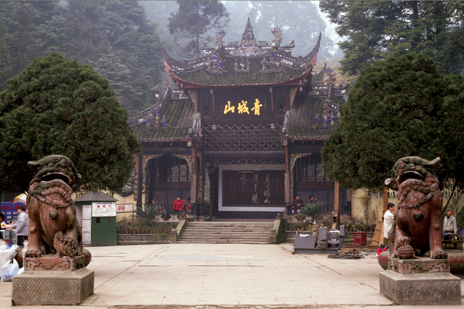
Qingchengshan-Dujiangyan National Park
China · 30.9068° N, 103.5679° E · 54 km from Chengdu
Construction of the Dujiangyan irrigation system began in the 3rd century B.C. This system still controls the waters of the Minjiang River and distributes it to the fertile farmland of the Chengdu plains. Mount Qingcheng was the birthplace of Taoism, which is celebrated in a series of ancient temples.
Description from the UNESCO World Heritage Centre (CC BY-SA IGO 3.0).
Why Qingchengshan-Dujiangyan National Park Is Listed
- (ii)
- An important interchange of human values.
- (iv)
- An outstanding example of a type of building or landscape.
- (vi)
- A direct association with events, ideas or beliefs of universal significance.

Yungang Grottoes
China · 40.1097° N, 113.1222° E · 3 km² · 15 km from Datong
The Yungang Grottoes (simplified Chinese: 云冈石窟; traditional Chinese: 雲岡石窟; pinyin: Yúngāng shíkū), formerly the Wuzhoushan Grottoes (Chinese: 武州山 / 武周山; pinyin: Wǔzhōushān), are ancient Chinese Buddhist temple grottoes built during the Northern Wei dynasty near the city of Datong, then called Pingcheng, in the province of Shanxi. They are excellent examples of rock-cut architecture and one of the three most famous ancient Buddhist sculptural sites of China. The others are Longmen and Mogao.
The site is located about 16 km west of the city of Datong, in the valley of the Shi Li river at the base of the Wuzhou Shan mountains. They are an outstanding example of the Chinese stone carvings from the 5th and 6th centuries. There are 53 major caves, along with 51,000 niches housing the same number of Buddha statues. Additionally, there are around 1,100 minor caves. A Ming dynasty-era fort is still located on top of the cliff housing the Yungang Grottoes.
The grottoes were excavated in the south face of a sandstone cliff about 2,600 feet long and 30 to 60 feet high. In 2001, the Yungang Grottoes were made a UNESCO World Heritage Site.
Adapted from Wikipedia: Yungang Grottoes (CC BY-SA 4.0).
Why Yungang Grottoes Is Listed
- (i)
- A masterpiece of human creative genius.
- (ii)
- An important interchange of human values.
- (iii)
- A unique testimony to a cultural tradition or civilisation.
- (iv)
- An outstanding example of a type of building or landscape.
More about Yungang Grottoes
UNESCO's Description
The Yungang Grottoes, in Datong city, Shanxi Province, with their 252 caves and 51,000 statues, represent the outstanding achievement of Buddhist cave art in China in the 5th and 6th centuries. The Five Caves created by Tan Yao, with their strict unity of layout and design, constitute a classical masterpiece of the first peak of Chinese Buddhist art.
From the UNESCO World Heritage Centre (CC BY-SA IGO 3.0).
History
After the decline of the Western Jin dynasty, the northern parts of China came under the control of the Tuoba-ruled Northern Wei. They made the city of Pingcheng (平城), now known as Datong (大同), their capital. Due to its promotion, Pingcheng saw an increase in construction work. The Northern Wei early adopted Buddhism as their state religion. Buddhism arrived in this location via travel on the ancient North Silk Road, the northernmost route of about 2600 kilometres in length, which connected the ancient Chinese capital of Chang'an to the west over the Wushao Ling Pass to Wuwei and emerging in Kashgar before linking to ancient Parthia.
The work on this first period of carving lasted until the year 465 AD, and these caves are now known as caves 16–20.
Sections adapted from Wikipedia: Yungang Grottoes (CC BY-SA 4.0).
Visiting Yungang Grottoes
Datong (大同 Dàtóng) is a city in northern Shanxi Province, China. A former frontier town and Northern Wei capital, it is best known for the Yungang Grottoes and the Hanging Monastery, as well as numerous religious sites in its redeveloped Ancient City center.
Travel notes adapted from Wikivoyage: Datong (CC BY-SA 4.0).

Three Parallel Rivers National Park
China · 27.8950° N, 98.4064° E
The Three Parallel Rivers of Yunnan Protected Areas (Chinese: 云南三江并流; pinyin: Yúnnán Sānjiāng Bìngliú) is a UNESCO World Heritage Site in Yunnan province, China. It lies within the drainage basins of the upper reaches of the Jinsha (Yangtze), Lancang (Mekong) and Nujiang (Salween) rivers, in the Yunnan section of the Hengduan Mountains.
Adapted from Wikipedia: Three Parallel Rivers (CC BY-SA 4.0).
Why Three Parallel Rivers National Park Is Listed
- (vii)
- Superlative natural phenomena or exceptional natural beauty.
- (viii)
- An outstanding example of major stages of the Earth's history.
- (ix)
- An outstanding example of ongoing ecological and biological processes.
- (x)
- The most important natural habitats for conserving biodiversity.
More about Three Parallel Rivers National Park
UNESCO's Description
Consisting of eight geographical clusters of protected areas within the boundaries of the Three Parallel Rivers National Park, in the mountainous north-west of Yunnan Province, the 1.7 million hectare site features sections of the upper reaches of three of the great rivers of Asia: the Yangtze (Jinsha), Mekong and Salween run roughly parallel, north to south, through steep gorges which, in places, are 3,000 m deep and are bordered by glaciated peaks more than 6,000 m high. The site is an epicentre of Chinese biodiversity. It is also one of the richest temperate regions of the world in terms of biodiversity.
From the UNESCO World Heritage Centre (CC BY-SA IGO 3.0).
Geography
The protected areas extend over 15 core areas, totalling 939,441.4 ha, and buffer areas, totalling 758,977.8 ha across a region of 180 km by 310 km. Here, for a distance of over 300 km, three of Asia's great rivers run roughly parallel to one another though separated by high mountain ranges with peaks over 6,000 meters. After this area of near confluence, the rivers greatly diverge: the Nujiang River becomes Salween and empties out at Moulmein, Burma, into the Indian Ocean; the Lancang becomes the Mekong and empties at south of Ho Chi Minh City, Vietnam into the South China Sea; and the Yangtze flows into the East China Sea at Shanghai.
Sections adapted from Wikipedia: Three Parallel Rivers (CC BY-SA 4.0).
Key Facts
| Area | 16,984 km² |
|---|
Facts from Wikidata Q575035 (CC0).

Capital Cities and Tombs of the Ancient Koguryo Kingdom
China · 41.1569° N, 126.1872° E · 42 km² · 9 km from Manpo
The Capital Cities and Tombs of the Ancient Koguryo Kingdom is an UNESCO World Heritage Site which includes a number of archaeological sites currently in Ji'an, Jilin Province and Huanren, Liaoning Province in Northeast China. Goguryeo (or Koguryo, "Gaogouli" in Chinese), (37 BCE – 668 CE) was a Korean Kingdom located in the northern and central parts of the Korean Peninsula and the southern and central parts of Manchuria.
The archaeological sites were collectively designated a cultural World Heritage Site in 2004, qualifying as such under the first five of the six criteria for cultural heritage sites. The designation includes the archaeological remains of three fortress-cities: Wunü Mountain City, Gungnae and Hwando, and forty identified tombs of Goguryeo imperial and noble families.
In 2010, the Chinese government established the Ji'an Gaogouli National Archaeological Park (Chinese: 集安高句丽考古遗址公园), which includes all of the Goguryeo World Heritage Sites in Ji'an and Jilin, but not the ones in Liaoning (such as Wunü Mountain City).
North Korea initially attempted to register the world heritage of the sites from around 2000.
Adapted from Wikipedia: Capital Cities and Tombs of the Ancient Koguryo Kingdom (CC BY-SA 4.0).
Why Capital Cities and Tombs of the Ancient Koguryo Kingdom Is Listed
- (i)
- A masterpiece of human creative genius.
- (ii)
- An important interchange of human values.
- (iii)
- A unique testimony to a cultural tradition or civilisation.
- (iv)
- An outstanding example of a type of building or landscape.
- (v)
- An outstanding example of traditional human settlement or land use.
More about Capital Cities and Tombs of the Ancient Koguryo Kingdom
UNESCO's Description
The site includes archaeological remains of three cities and 40 tombs: Wunu Mountain City, Guonei City and Wandu Mountain City, 14 tombs are imperial, 26 of nobles. All belong to the Koguryo culture, named after the dynasty that ruled over parts of northern China and the northern half of the Korean Peninsula from 277 BC to AD 668. Wunu Mountain City is only partly excavated. Guonei City, within the modern city of Ji’an, played the role of a ‘supporting capital’ after the main Koguryo capital moved to Pyongyang. Wandu Mountain City, one of the capitals of the Koguryo Kingdom, contains many vestiges including a large palace and 37 tombs. Some of the tombs show great ingenuity in their elaborate ceilings, designed to roof wide spaces without columns and carry the heavy load of a stone or earth tumulus (mound), which was placed above them.
From the UNESCO World Heritage Centre (CC BY-SA IGO 3.0).
Key Facts
| Area | 41.6 km² |
|---|
Facts from Wikidata Q134873 (CC0).
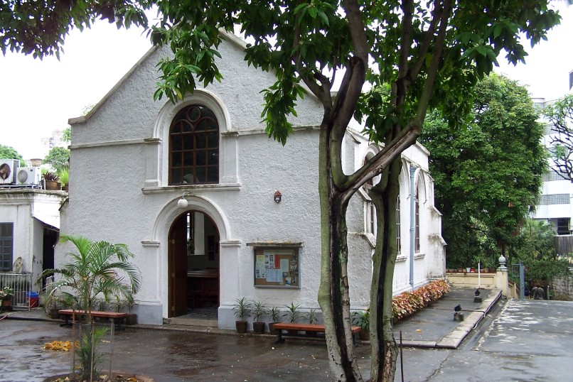
Macau Protestant Chapel
China · 22.1998° N, 113.5399° E · 1 km from Macau
Morrison Chapel (Portuguese: Capela Protestante; Chinese: 馬禮遜教堂), also known as Morrison Protestant Chapel, is an Anglican chapel situated in Luís de Camões Square, Santo António, Macau Peninsula, Macau. Originally built in the early 19th century to serve the spiritual needs of the employees of East India Company, the chapel now serves the worshipers with a variety of denominational backgrounds in the Missionary Area of Macau. The present chapel was built in 1922.
Adapted from Wikipedia: Macau Protestant Chapel (CC BY-SA 4.0).
Why Macau Protestant Chapel Is Listed
- (ii)
- An important interchange of human values.
- (iii)
- A unique testimony to a cultural tradition or civilisation.
- (iv)
- An outstanding example of a type of building or landscape.
- (vi)
- A direct association with events, ideas or beliefs of universal significance.
More about Macau Protestant Chapel
UNESCO's Description
Macao, a lucrative port of strategic importance in the development of international trade, was under Portuguese administration from the mid-16th century until 1999, when it came under Chinese sovereignty. With its historic street, residential, religious and public Portuguese and Chinese buildings, the historic centre of Macao provides a unique testimony to the meeting of aesthetic, cultural, architectural and technological influences from East and West. The site also contains a fortress and a lighthouse, the oldest in China. It bears witness to one of the earliest and longest-lasting encounters between China and the West, based on the vibrancy of international trade.
From the UNESCO World Heritage Centre (CC BY-SA IGO 3.0).
History
Traders of the East India Company were engaged in trade with China from the late 18th century until 1834. Their charter includes stipulations that employees of the company should be allowed to attend religious services on a regular basis and chaplains should be sent out from England to take care of the spiritual needs of employees.
Before 1821, when the land for a chapel and burial ground (now the Old Protestant Cemetery) was purchased, the chapel was probably simply a room at the offices of the British East India Company. The purchase of the burial ground was prompted by the death of Mary Morrison, wife of Robert Morrison, missionary and translator employed by the East India Company. Prior to this, the Portuguese authorities had only allowed Roman Catholic burials in the colony.
Sections adapted from Wikipedia: Macau Protestant Chapel (CC BY-SA 4.0).

Sichuan Giant Panda Sanctuaries
China · 30.8333° N, 103.0000° E · 9,245 km² · 95 km from Yaan
The Sichuan Giant Panda Sanctuaries (simplified Chinese: 四川大熊猫栖息地; traditional Chinese: 四川大熊貓棲息地; pinyin: Sìchuān Dàxióngmāo Qīxīdì) located in southwest Sichuan province of China, is the home to more than 30% of the world's giant pandas and is among the most important sites for the captive breeding of these pandas. It covers 9245 km2 with seven nature reserves and nine scenic parks in the Qionglai and Jiajin Mountains. Along with the giant panda, the sanctuary is a refuge to other endangered species such as the red panda, the snow leopard, and the clouded leopard. Outside of the tropical rainforests, it is among the botanically richest sites of the world, and is home to between 5,000 and 6,000 species of flora. It has been noted that the region is similar to the paleo-tropic forests of the Paleogene Periods. Because of its biodiversity and conservation of giant pandas, these sanctuaries were listed as UNESCO World Heritage Sites in 2006.
Adapted from Wikipedia: Sichuan Giant Panda Sanctuaries (CC BY-SA 4.0).
Why Sichuan Giant Panda Sanctuaries Is Listed
- (x)
- The most important natural habitats for conserving biodiversity.
More about Sichuan Giant Panda Sanctuaries
UNESCO's Description
Sichuan Giant Panda Sanctuaries, home to more than 30% of the world's pandas which are classed as highly endangered, covers 924,500 ha with seven nature reserves and nine scenic parks in the Qionglai and Jiajin Mountains. The sanctuaries constitute the largest remaining contiguous habitat of the giant panda, a relict from the paleo-tropic forests of the Tertiary Era. It is also the species' most important site for captive breeding. The sanctuaries are home to other globally endangered animals such as the red panda, the snow leopard and clouded leopard. They are among the botanically richest sites of any region in the world outside the tropical rainforests, with between 5,000 and 6,000 species of flora in over 1,000 genera.
From the UNESCO World Heritage Centre (CC BY-SA IGO 3.0).
Key Facts
| Area | 9,245 km² |
|---|
Facts from Wikidata Q629902 (CC0).

Yinxu
China · 36.1225° N, 114.3186° E · 4 km² · 5 km from Anyang
Yinxu (Mandarin pronunciation: [ín.ɕý]; Chinese: 殷墟; lit. 'Ruins of Yin') is a Chinese archeological site corresponding to Yin, the final capital of the Shang dynasty (c. 1600 – c. 1046 BCE). Located in present-day Anyang, Henan, Yin served as the capital during the Late Shang period (c. 1250 – c. 1046 BCE) which spanned the reigns of 12 Shang kings and saw the emergence of oracle bone script, the earliest known Chinese writing. Along with oracle bone script and other material evidence for the Shang's existence, the site was forgotten for millennia. Its rediscovery in 1899 resulted from an investigation into oracle bones that were discovered being sold nearby. The rediscovery of Yinxu marked the beginning of decades of intensive excavation and study. It is one of China's oldest and largest archeological sites, and was selected by UNESCO as a World Heritage Site in 2006. Yinxu is located in northern Henan, near modern Anyang and the borders Henan shares with Hebei and Shanxi. Public access to the site is permitted.
Adapted from Wikipedia: Yinxu (CC BY-SA 4.0).
Why Yinxu Is Listed
- (ii)
- An important interchange of human values.
- (iii)
- A unique testimony to a cultural tradition or civilisation.
- (iv)
- An outstanding example of a type of building or landscape.
- (vi)
- A direct association with events, ideas or beliefs of universal significance.
More about Yinxu
UNESCO's Description
The archaeological site of Yin Xu, close to Anyang City, some 500 km south of Beijing, is an ancient capital city of the late Shang Dynasty (1300 - 1046 BC). It testifies to the golden age of early Chinese culture, crafts and sciences, a time of great prosperity of the Chinese Bronze Age. A number of royal tombs and palaces, prototypes of later Chinese architecture, have been unearthed on the site, including the Palace and Royal Ancestral Shrines Area, with more than 80 house foundations, and the only tomb of a member of the royal family of the Shang Dynasty to have remained intact, the Tomb of Fu Hao. The large number and superb craftsmanship of the burial accessories found there bear testimony to the advanced level of Shang crafts industry. Inscriptions on oracle bones found in Yin Xu bear invaluable testimony to the development of one of the world’s oldest writing systems, ancient beliefs and social systems.
From the UNESCO World Heritage Centre (CC BY-SA IGO 3.0).
Traditional history
According to the 2nd century Shuowen Jiezi dictionary (說文解字), the Chinese character "殷" (yīn) originally referred to "vibrant music-making". Although frequently used throughout written history to refer to both the Shang dynasty and its final capital, the name Yīn (殷) appears to have not been used in this way until the succeeding Zhou dynasty. In particular, the name does not appear in the oracle bones, which refer to the state as Shāng (商), and its final capital as Dàyì Shāng (大邑商 "Great Settlement Shang").
Among surviving ancient Chinese historical documents, Yin is described as the final capital of the Shang dynasty. There is some disagreement, though, as to when the move to Yin took place.
Sections adapted from Wikipedia: Yinxu (CC BY-SA 4.0).
Visiting Yinxu
For the city in South Korea, see Anyang (Gyeonggi).
Anyang (安阳; Ānyáng) is a city of about 5.4 million (2023), a prefecture-level city and the northernmost city in Henan Province. It is 120 km north of the Yellow River and 460 km south of Beijing.
Anyang City is very much a historic city, one of the eight ancient capitals of China, the hometown of Oracle, the birthplace of the spirit of the Red Flag Canal. In 2023, Anyang received 70 million domestic and foreign tourists.
Travel notes adapted from Wikivoyage: Anyang (CC BY-SA 4.0).

Kaiping Diaolou and Villages
China · 22.2618° N, 112.5208° E · 4 km² · 68 km from Jiangmen
Kaiping Diaolou and Villages feature the Diaolou, multi-storeyed defensive village houses in Kaiping, which display a complex and flamboyant fusion of Chinese and Western structural and decorative forms. They reflect the significant role of émigré Kaiping people in the development of several countries in South Asia, Australasia and North America, during the late 19th and early 20th centuries. There are four groups of Diaolou and twenty of the most symbolic ones are inscribed on the List. These buildings take three forms: communal towers built by several families and used as temporary refuge, residential towers built by individual rich families and used as fortified residences, and watch towers. Built of stone, pise , brick or concrete, these buildings represent a complex and confident fusion between Chinese and Western architectural styles. Retaining a harmonious relationship with the surrounding landscape, the Diaolou testify to the final flowering of local building traditions that started in the Ming period in response to local banditry.
Description from the UNESCO World Heritage Centre (CC BY-SA IGO 3.0).
Why Kaiping Diaolou and Villages Is Listed
- (ii)
- An important interchange of human values.
- (iii)
- A unique testimony to a cultural tradition or civilisation.
- (iv)
- An outstanding example of a type of building or landscape.

South China Karst
China · 24.9233° N, 110.3544° E · 971 km² · 41 km from Guilin
The South China Karst (simplified Chinese: 中国南方喀斯特; traditional Chinese: 中國南方喀斯特; pinyin: Zhōngguó Nánfāng Kāsītè), a UNESCO World Heritage Site since June 2007, spans the provinces of Chongqing, Guangxi, Guizhou, and Yunnan. It is noted for its karst features and landscapes as well as rich biodiversity. The site comprises seven clusters Phase I: Libo Karst, Shilin Karst, and Wulong Karst inscribed in 2007, and Phase II: Guilin Karst, Shibing Karst, Jinfoshan Karst, and Huanjiang Karst inscribed in 2014. UNESCO describes the South China Karst as "unrivalled in terms of the diversity of its karst features and landscapes".
The huge karst area of South China is about 550,000 km2 in extent. The karst terrain displays a geomorphic transition as the terrain gradually descends about 2000 meters over 700 kilometers from the western Yunnan-Guizhou Plateau (averaging 2100 meters elevation) to the eastern Guangxi Basin (averaging 110 meters elevation). The region is recognized as the world’s type area for karst landform development in the humid tropics and subtropics.
Adapted from Wikipedia: South China Karst (CC BY-SA 4.0).
Why South China Karst Is Listed
- (vii)
- Superlative natural phenomena or exceptional natural beauty.
- (viii)
- An outstanding example of major stages of the Earth's history.
More about South China Karst
UNESCO's Description
South China Karst is one of the world’s most spectacular examples of humid tropical to subtropical karst landscapes. It is a serial site spread over the provinces of Guizhou, Guangxi, Yunnan and Chongqing and covers 97,125 hectares. It contains the most significant types of karst landforms, including tower karst, pinnacle karst and cone karst formations, along with other spectacular characteristics such as natural bridges, gorges and large cave systems. The stone forests of Shilin are considered superlative natural phenomena and a world reference. The cone and tower karsts of Libo, also considered the world reference site for these types of karst, form a distinctive and beautiful landscape. Wulong Karst has been inscribed for its giant dolines (sinkholes), natural bridges and caves.
From the UNESCO World Heritage Centre (CC BY-SA IGO 3.0).

Fujian Tulou sites
China · 24.6587° N, 116.9750° E · 2 km² · 58 km from Longyan
The Fujian tulou (simplified Chinese: 福建土楼; traditional Chinese: 福建土樓; pinyin: Fújiàn tǔlóu; lit. 'Fujian earthen buildings') are Chinese rural dwellings unique to the Hakka in the mountainous areas in southeastern Fujian, China. They were mostly built between the 12th and the 20th centuries.
A tulou is usually a large, enclosed and fortified earth building, most commonly rectangular or circular in configuration, with very thick load-bearing rammed earth walls between three and five stories high and housing up to 800 people. Smaller interior buildings are often enclosed by these huge peripheral walls which can contain halls, storehouses, wells and living areas, the whole structure resembling a small fortified city.
The fortified outer structures are formed by compacting earth, mixed with stone, bamboo, wood and other readily available materials to form walls up to 6 feet (1.8 m) thick. Branches, strips of wood and bamboo chips are often laid in the wall as additional reinforcement. The result is a well-lit, well-ventilated, windproof and earthquake-proof building that is warm in winter and cool in summer.
Adapted from Wikipedia: Fujian tulou (CC BY-SA 4.0).
Why Fujian Tulou sites Is Listed
- (iii)
- A unique testimony to a cultural tradition or civilisation.
- (iv)
- An outstanding example of a type of building or landscape.
- (v)
- An outstanding example of traditional human settlement or land use.
More about Fujian Tulou sites
UNESCO's Description
Fujian Tulou is a property of 46 buildings constructed between the 15th and 20th centuries over 120 km in south-west of Fujian province, inland from the Taiwan Strait. Set amongst rice, tea and tobacco fields the Tulou are earthen houses. Several storeys high, they are built along an inward-looking, circular or square floor plan as housing for up to 800 people each. They were built for defence purposes around a central open courtyard with only one entrance and windows to the outside only above the first floor. Housing a whole clan, the houses functioned as village units and were known as “a little kingdom for the family” or “bustling small city.” They feature tall fortified mud walls capped by tiled roofs with wide over-hanging eaves. The most elaborate structures date back to the 17th and 18th centuries. The buildings were divided vertically between families with each disposing of two or three rooms on each floor. In contrast with their plain exterior, the inside of the tulou were built for comfort and were often highly decorated. They are inscribed as exceptional examples of a building tradition and function exemplifying a particular type of communal living and defensive organization, and, in terms of their harmonious relationship with their environment, an outstanding example of human settlement.
From the UNESCO World Heritage Centre (CC BY-SA IGO 3.0).

Mount Sanqing
China · 28.9519° N, 118.0519° E · 230 km² · 54 km from Shangrao
Mount Sanqing (Chinese: 三清山; pinyin: Sānqīng Shān) is a renowned Taoist sacred mountain located 40 kilometres (25 mi) north of Yushan County in Jiangxi Province. Sanqing means the "Three Pure Ones" in Chinese as Mount Sanqing is made up of three main summits: Yujing, Yushui, and Yuhua, representing the Taoist trinity.
A Chinese phrase “三峰峻拔、如三清列坐其巅” ("Three steep peaks, like the Three Pure Ones sit the summits") explains why it was named San Qing. Amongst the three hills, the Yujing hill (1817 meters above sea level) is the highest.
Mount Sanqing is the highest of the Huaiyu Mountains and is known for its outstanding scenery and unique geological formations. The area became a National Geopark in 2005, and a UNESCO World Heritage Site in 2008.
It is a famous tourist destination as well as a refuge for animals and plants. The national park contains more than 2,300 species of plants and 400 species of vertebrates. The total area of Mount Sanqing is 229 km2.
Adapted from Wikipedia: Mount Sanqing (CC BY-SA 4.0).
Why Mount Sanqing Is Listed
- (vii)
- Superlative natural phenomena or exceptional natural beauty.
More about Mount Sanqing
UNESCO's Description
Mount Sanqingshan National Park, a 22,950 ha property located in the west of the Huyaiyu mountain range in the northeast of Jiangxi Province (in the east of central China) has been inscribed for its exceptional scenic quality, marked by the concentration of fantastically shaped pillars and peaks: 48 granite peaks and 89 granite pillars, many of which resemble human or animal silhouettes. The natural beauty of the 1,817 metre high Mount Huaiyu is further enhanced by the juxtaposition of granite features with the vegetation and particular meteorological conditions which make for an ever-changing and arresting landscape with bright halos on clouds and white rainbows. The area is subject to a combination of subtropical monsoonal and maritime influences and forms an island of temperate forest above the surrounding subtropical landscape. It also features forests and numerous waterfalls, some of them 60 metres in height, lakes and springs.
From the UNESCO World Heritage Centre (CC BY-SA IGO 3.0).
Geological History and Hydrology
Mount Sanqing is a granite mountain that forms a part of a crustal suture zone dating back to the Neoproterozoic Era, roughly 850 million years ago. However, the granite making up much of the mountain peaks dates from the Mesozoic. Faulting, weathering and erosion have shaped the mountains into intricate landforms. On Mount Sanqing, there are more than 23 gorges with more than 500 meters of elevation. The abundant yearly rainfall in the region allows for many waterfalls (some of which are over 60 meters in height), pools, and springs in the region.
Sections adapted from Wikipedia: Mount Sanqing (CC BY-SA 4.0).
Key Facts
| Established | 2008 |
|---|---|
| Area | 2,200 km² |
Facts from Wikidata Q873358 (CC0).

Mount Wutai
China · 39.0814° N, 113.5669° E · 184 km² · 102 km from Shuozhou
Mount Wutai, also known by its Chinese name Wutaishan and as Mount Qingliang, is a sacred Buddhist site at the headwaters of the Qingshui in Shanxi Province, China. Its central area is surrounded by a cluster of flat-topped peaks or mesas roughly corresponding to the cardinal directions. The north peak (Beitai Ding or Yedou Feng) is the highest (3,061 m or 10,043 ft from sea) and is also the highest point in North China.
As host to over 53 sacred monasteries, Mount Wutai is home to many of China's most important monasteries and temples. It was inscribed as a UNESCO World Heritage Site in 2009 and named a AAAAA tourist attraction by China's National Tourism Administration in 2007.
Adapted from Wikipedia: Mount Wutai (CC BY-SA 4.0).
Why Mount Wutai Is Listed
- (ii)
- An important interchange of human values.
- (iii)
- A unique testimony to a cultural tradition or civilisation.
- (iv)
- An outstanding example of a type of building or landscape.
- (vi)
- A direct association with events, ideas or beliefs of universal significance.
More about Mount Wutai
UNESCO's Description
With its five flat peaks, Mount Wutai is a sacred Buddhist mountain. The cultural landscape is home to forty-one monasteries and includes the East Main Hall of Foguang Temple, the highest surviving timber building of the Tang dynasty, with life-size clay sculptures. It also features the Ming dynasty Shuxiang Temple with a huge complex of 500 statues representing Buddhist stories woven into three-dimensional pictures of mountains and water. Overall, the buildings on the site catalogue the way in which Buddhist architecture developed and influenced palace building in China for over a millennium. Mount Wutai, literally, 'the five terrace mountain', is the highest in Northern China and is remarkable for its morphology of precipitous slopes with five open treeless peaks. Temples have been built on this site from the 1st century AD to the early 20th century.
From the UNESCO World Heritage Centre (CC BY-SA IGO 3.0).
Climate
Mount Wutai has a subarctic climate (Köppen climate classification Dwc). The average annual temperature in Haidian is 2.2 °C (36.0 °F). The average annual rainfall is 686.7 mm (27.04 in) with July as the wettest month. The temperatures are highest on average in July, at around 15.0 °C (59.0 °F), and lowest in January, at around −11.8 °C (10.8 °F). The temperature in Mount Wutai is comfortable from July to August, which is suitable for travel. It's very cold from November to March. The extreme low temperature in Mount Wutai occurred on 15 January 1958, which was -44.8°C.
Sections adapted from Wikipedia: Mount Wutai (CC BY-SA 4.0).
Visiting Mount Wutai
Mount Wǔtái (五台山 Wǔtái Shān), is one of the four Sacred Buddhist mountains of China, and a UNESCO World Heritage Site in Shanxi Province in China, AAAAA Tourist Attractions of China.
Travel notes adapted from Wikivoyage: Wutaishan National Park (CC BY-SA 4.0).

China Danxia
China · 28.4219° N, 106.0430° E · 822 km² · 83 km from Luzhou
The Danxia landform (Chinese: 丹霞地貌; pinyin: dānxiá dìmào; Jyutping: daan1haa4 dei6maau6) is a set of landscapes found in southeast, southwest and northwest China that "consist of a red bed characterized by steep cliffs". It is a unique type of petrographic geomorphology found in China. Danxia landform is formed from red-coloured sandstones and conglomerates of largely Cretaceous age. The landforms look very much like karst topography that forms in areas underlain by limestones, but since the rocks that form danxia are sandstones and conglomerates, they have been called "pseudo-karst" landforms. They were formed by endogenous forces (including uplift) and exogenous forces (including weathering and erosion).
The first studies on what are now referred to as Danxia landforms were conducted at Mount Danxia near Shaoguan, China. In the 1920s and 1930s Chinese geologists made an effort to learn more about these interesting geomorphic structures. Danxia landforms are made up of uplifted continental crust that has been faulted and eroded, exposing large scarps of layered rock, red in color.
Danxia landforms cover several provinces in southeast China.
Adapted from Wikipedia: Danxia landform (CC BY-SA 4.0).
Why China Danxia Is Listed
- (vii)
- Superlative natural phenomena or exceptional natural beauty.
- (viii)
- An outstanding example of major stages of the Earth's history.
More about China Danxia
UNESCO's Description
China Danxia is the name given in China to landscapes developed on continental red terrigenous sedimentary beds influenced by endogenous forces (including uplift) and exogenous forces (including weathering and erosion). The inscribed site comprises six areas found in the sub-tropical zone of south-west China. They are characterized by spectacular red cliffs and a range of erosional landforms, including dramatic natural pillars, towers, ravines, valleys and waterfalls. These rugged landscapes have helped to conserve sub-tropical broad-leaved evergreen forests, and host many species of flora and fauna, about 400 of which are considered rare or threatened.
From the UNESCO World Heritage Centre (CC BY-SA IGO 3.0).
Geology
Around 80 million years ago (Ma) cretaceous red sandstone and conglomerate was laid down by sedimentation from the lakes and streams. After another 15 million years, tectonic plate movements created many faults. About 23 Ma, movement of the Himalayan range disturbed the land around the danxia landform in the Guangdong province uplifting and completely changing the topography of the area. Over millions of years the steep cliffs that can be seen today, exposed by faults, were formed through weathering and erosion. This geology can be seen at Danxiashan Geopark in China, where there is about 290 square kilometers of streams, forest and towering danxian rock formations.
Sections adapted from Wikipedia: Danxia landform (CC BY-SA 4.0).

Historic Monuments of Dengfeng in “The Centre of Heaven and Earth”
China · 34.4588° N, 113.0677° E · 8 km² · 60 km from Luoyang
Mount Songshang is considered to be the central sacred mountain of China. At the foot of this 1500 metre high mountain, close to the city of Dengfeng in Henan province and spread over a 40 square-kilometre circle, stand eight clusters of buildings and sites, including three Han Que gates - remains of the oldest religious edifices in China -, temples, the Zhougong Sundial Platform and the Dengfeng Observatory. Constructed over the course of nine dynasties, these buildings are reflections of different ways of perceiving the centre of heaven and earth and the power of the mountain as a centre for religious devotion. The historical monuments of Dengfeng include some of the best examples of ancient Chinese buildings devoted to ritual, science, technology and education.
Description from the UNESCO World Heritage Centre (CC BY-SA IGO 3.0).
Why Historic Monuments of Dengfeng in “The Centre of Heaven and Earth” Is Listed
- (iii)
- A unique testimony to a cultural tradition or civilisation.
- (vi)
- A direct association with events, ideas or beliefs of universal significance.
West Lake Cultural Landscape of Hangzhou
China · 30.2375° N, 120.1408° E · 33 km² · 3 km from Hangzhou
The West Lake Cultural Landscape of Hangzhou, comprising the West Lake and the hills surrounding its three sides, has inspired famous poets, scholars and artists since the 9th century. It comprises numerous temples, pagodas, pavilions, gardens and ornamental trees, as well as causeways and artificial islands. These additions have been made to improve the landscape west of the city of Hangzhou to the south of the Yangtze river. The West Lake has influenced garden design in the rest of China as well as Japan and Korea over the centuries and bears an exceptional testimony to the cultural tradition of improving landscapes to create a series of vistas reflecting an idealised fusion between humans and nature.
Description from the UNESCO World Heritage Centre (CC BY-SA IGO 3.0).
Why West Lake Cultural Landscape of Hangzhou Is Listed
- (ii)
- An important interchange of human values.
- (iii)
- A unique testimony to a cultural tradition or civilisation.
- (vi)
- A direct association with events, ideas or beliefs of universal significance.

Chengjiang Fossil Site
China · 24.6689° N, 102.9772° E · 5 km² · 52 km from Yuxi
Chengjiang (simplified Chinese: 澄江; traditional Chinese: 澂江; pinyin: Chéngjiāng; earlier Tchinkiang) is a city located in Yuxi, Yunnan Province, China, just north of Fuxian Lake.
Adapted from Wikipedia: Chengjiang (CC BY-SA 4.0).
Why Chengjiang Fossil Site Is Listed
- (viii)
- An outstanding example of major stages of the Earth's history.
More about Chengjiang Fossil Site
UNESCO's Description
A hilly 512 ha site in Yunnan province, Chengjiang’s fossils present the most complete record of an early Cambrian marine community with exceptionally preserved biota, displaying the anatomy of hard and soft tissues in a very wide variety of organisms, invertebrate and vertebrate. They record the early establishment of a complex marine ecosystem. The site documents at least sixteen phyla and a variety of enigmatic groups as well as about 196 species, presenting exceptional testimony to the rapid diversification of life on Earth 530 million years ago, when almost all of today’s major animal groups emerged. It opens a palaeobiological window of great significance to scholarship.
From the UNESCO World Heritage Centre (CC BY-SA IGO 3.0).

Xanadu
China · 42.3580° N, 116.1852° E · 251 km²
Shangdu (Chinese: 上都; pinyin: Shàngdū; lit. "Upper Capital"; Mongolian: Шанду), known in the West as Xanadu, was the summer capital of the Yuan dynasty. Located in what is now Zhenglan Banner, Inner Mongolia, it was designed by Chinese architect Liu Bingzhong and served as a seasonal retreat blending Mongolian steppe traditions with Chinese urban planning. The site gained legendary status after it was visited by Marco Polo and later inspired the English poet Samuel Taylor Coleridge.
In 2012, it was designated a UNESCO World Heritage Site for its cultural and historical significance. A railway is under construction from Beijing to Zhenglan Banner and will open in 2026.
Adapted from Wikipedia: Shangdu (CC BY-SA 4.0).
Why Xanadu Is Listed
- (ii)
- An important interchange of human values.
- (iii)
- A unique testimony to a cultural tradition or civilisation.
- (iv)
- An outstanding example of a type of building or landscape.
- (vi)
- A direct association with events, ideas or beliefs of universal significance.
More about Xanadu
UNESCO's Description
North of the Great Wall, the Site of Xanadu encompasses the remains of Kublai Khan’s legendary capital city, designed by the Mongol ruler’s Chinese advisor Liu Bingzhdong in 1256. Over a surface area of 25,000 ha, the site was a unique attempt to assimilate the nomadic Mongolian and Han Chinese cultures. From this base, Kublai Khan established the Yuan dynasty that ruled China over a century, extending its boundaries across Asia. The religious debate that took place here resulted in the dissemination of Tibetan Buddhism over north-east Asia, a cultural and religious tradition still practised in many areas today. The site was planned according to traditional Chinese feng shui in relation to the nearby mountains and river. It features the remains of the city, including temples, palaces, tombs, nomadic encampments and the Tiefan’gang Canal, along with other waterworks.
From the UNESCO World Heritage Centre (CC BY-SA IGO 3.0).
History
Shangdu, originally named Kaiping (開平), was established between 1252 and 1256 by Liu Bingzhong, a trusted advisor to Kublai Khan and a former Buddhist monk. Liu implemented a "profoundly Chinese scheme for the city's architecture", blending Confucian city planning with Mongolian steppe traditions. In 1264, Kublai Khan renamed the city Shangdu and established it as the summer capital of the Yuan dynasty.
Located in the grasslands north of the Great Wall—about 350 km north of Beijing and 28 km northwest of present-day Duolun County—Shangdu was designed with a triple structure: an outer city, an inner city, and a central imperial palace. The palace enclosure measured roughly 550 meters per side, corresponding to about 40% of the later Forbidden City in Beijing.
Sections adapted from Wikipedia: Shangdu (CC BY-SA 4.0).

Cultural Landscape of Old Tea Forests of the Jingmai Mountain in Pu’er
China · 22.2013° N, 100.0264° E · 72 km² · 117 km from Simao
Located on Jingmai Mountain in southwestern China, this cultural landscape was developed over a thousand years by the Blang and Dai peoples following practices that began in the 10th century. The property is a tea production area comprised of traditional villages within old tea groves surrounded by forests and tea plantations. The traditional understorey cultivation of old tea trees is a method that responds to the specific conditions of the mountain’s ecosystem and subtropical monsoon climate, combined with a governance system maintained by the local Indigenous communities. Traditional ceremonies and festivities relate to the Tea Ancestor belief that spirits live in the tea plantations and in the local fauna and flora, a belief that is at the core of this cultural tradition.
Description from the UNESCO World Heritage Centre (CC BY-SA IGO 3.0).
Why Cultural Landscape of Old Tea Forests of the Jingmai Mountain in Pu’er Is Listed
- (iii)
- A unique testimony to a cultural tradition or civilisation.
- (iv)
- An outstanding example of a type of building or landscape.
- (v)
- An outstanding example of traditional human settlement or land use.

Honghe Hani Rice Terraces
China · 23.1172° N, 102.7377° E · 166 km² · 51 km from Gejiu
The Honghe Hani Rice Terraces are the system of Hani rice-growing terraces located in Yuanyang County, Honghe Prefecture, Yunnan, China. The terraces' history spans around 1,200 years. The total area stretches across 1,000,000 acres and four counties: Yuanyang, Honghe, Jinpin and Lüchun, although the core area of the terraces is located in Yuanyang County. In 2013, 16,603 hectares of the Honghe Hani Rice Terraces were listed as a World Heritage Site, because of their outstanding resilient construction, unique social-ecological system, and importance to the Hani people.
Adapted from Wikipedia: Honghe Hani Rice Terraces (CC BY-SA 4.0).
Why Honghe Hani Rice Terraces Is Listed
- (iii)
- A unique testimony to a cultural tradition or civilisation.
- (v)
- An outstanding example of traditional human settlement or land use.
More about Honghe Hani Rice Terraces
UNESCO's Description
The Cultural Landscape of Honghe Hani Rice Terraces, China covers 16,603-hectares in Southern Yunnan. It is marked by spectacular terraces that cascade down the slopes of the towering Ailao Mountains to the banks of the Hong River. Over the past 1,300 years, the Hani people have developed a complex system of channels to bring water from the forested mountaintops to the terraces. They have also created an integrated farming system that involves buffalos, cattle, ducks, fish and eel and supports the production of red rice, the area’s primary crop. The inhabitants worship the sun, moon, mountains, rivers, forests and other natural phenomena including fire. They live in 82 villages situated between the mountaintop forests and the terraces. The villages feature traditional thatched “mushroom” houses. The resilient land management system of the rice terraces demonstrates extraordinary harmony between people and their environment, both visually and ecologically, based on exceptional and long-standing social and religious structures.
From the UNESCO World Heritage Centre (CC BY-SA IGO 3.0).
Description
The Honghe Hani Rice Terraces are located on the southern banks of the Hong River, below the Ailao Mountains in southern Yunnan. The rough, mountainous terrain and high annual rainfall led to the creation of a complex terrace system for growing rice, with some locations having over 3000 terraces between the edge of the forest and the valley floor. Irrigation channels and artificial aquifers made out of sandstone distribute the water across the landscape. This system has been continually maintained and operated by the Hani people for over 1,300 years. The cultivation of rice is an important part of the Hani culture, theology, calendar, and political system.
Sections adapted from Wikipedia: Honghe Hani Rice Terraces (CC BY-SA 4.0).

Xinjiang Tianshan
China · 41.9683° N, 80.3542° E · 6,068 km² · 91 km from Aksu
Xinjiang Tianshan comprises four components—Tomur, Kalajun-Kuerdening, Bayinbukuke and Bogda— that total 606,833 hectares. They are part of the Tianshan mountain system of Central Asia, one of the largest mountain ranges in the world. Xinjiang Tianshan presents unique physical geographic features and scenically beautiful areas including spectacular snow and snowy mountains glacier-capped peaks, undisturbed forests and meadows, clear rivers and lakes and red bed canyons. These landscapes contrast with the vast adjacent desert landscapes, creating a striking visual contrast between hot and cold environments, dry and wet, desolate and luxuriant. The landforms and ecosystems of the site have been preserved since the Pliocene epoch and present an outstanding example of ongoing biological and ecological evolutionary processes. The site also extends into the Taklimakan Desert, one of the world’s largest and highest deserts, known for its large dune forms and great dust storms. Xinjiang Tianshan is moreover an important habitat for endemic and relic flora species, some rare and endangered.
Description from the UNESCO World Heritage Centre (CC BY-SA IGO 3.0).
Why Xinjiang Tianshan Is Listed
- (vii)
- Superlative natural phenomena or exceptional natural beauty.
- (ix)
- An outstanding example of ongoing ecological and biological processes.

Grand Canal
China · 30.2614° N, 120.2239° E · 208 km² · 5 km from Hangzhou
The Grand Canal (Chinese: 大运河; pinyin: Dà yùnhé) is a system of interconnected canals linking various major rivers and lakes in North and East China, serving as an important waterborne transport infrastructure between the north and the south during Medieval and premodern China. It is the longest artificial waterway in the world and a World Heritage Site.
The Grand Canal has undergone several route changes throughout history. Its current main stem, known as the Jing–Hang Grand Canal, is thought to extend for 1,776 km (1,104 mi) linking Beijing in the north to Hangzhou in the south, and is divided into 6 main subsections, with the southernmost sections remaining relatively unchanged over time.
Adapted from Wikipedia: Grand Canal (China) (CC BY-SA 4.0).
Why Grand Canal Is Listed
- (i)
- A masterpiece of human creative genius.
- (iii)
- A unique testimony to a cultural tradition or civilisation.
- (iv)
- An outstanding example of a type of building or landscape.
- (vi)
- A direct association with events, ideas or beliefs of universal significance.
More about Grand Canal
UNESCO's Description
The Grand Canal is a vast waterway system in the north-eastern and central-eastern plains of China, running from Beijing in the north to Zhejiang province in the south. Constructed in sections from the 5th century BC onwards, it was conceived as a unified means of communication for the Empire for the first time in the 7th century AD (Sui dynasty). This led to a series of gigantic construction sites, creating the world’s largest and most extensive civil engineering project prior to the Industrial Revolution. It formed the backbone of the Empire’s inland communication system, transporting grain and strategic raw materials, and supplying rice to feed the population. By the 13th century it consisted of more than 2,000 km of artificial waterways, linking five of China’s main river basins. It has played an important role in ensuring the country’s economic prosperity and stability and is still in use today as a major means of communication.
From the UNESCO World Heritage Centre (CC BY-SA IGO 3.0).
History
In the late Spring and Autumn period, King Fuchai of Wu (whose capital was in present-day Suzhou), ventured north to attack the State of Qi. He ordered a canal to be constructed for trading purposes, as well as a means to ship ample supplies north in case his forces should engage the northern states of Song and Lu. This became known as the Han or Hangou Canal (t 邗溝, s 邗沟, Hángōu). Work began in 486 BC, from south of Yangzhou to north of Huai'an in Jiangsu, and within three years the Han Canal had connected the Yangtze with the Huai River utilizing existing waterways, lakes, and marshes.
The Han Canal is known as the second oldest section of the later Grand Canal since the Hong Canal (t 鴻溝, s 鸿沟, Hónggōu, "Canal of the Wild Geese" or "Far-Flung Canal") most likely preceded it.
Sections adapted from Wikipedia: Grand Canal (China) (CC BY-SA 4.0).

Silk Roads: the Routes Network of Chang'an-Tianshan Corridor
China, Kyrgyzstan · 34.3044° N, 108.8572° E · 427 km² · 4 km from Xian
Silk Roads: The Routes Network of Chang'an-Tian Shan Corridor is a UNESCO World Heritage Site which covers the Chang'an-Tianshan portion of the ancient Silk Road and historical sites along the route. On June 22, 2014, UNESCO designated a 5,000 km (3,100 mi) stretch of the Silk Road network from Central China to the Zhetysu region of Central Asia as a World Heritage site. The corridor spans China, Kazakhstan and Kyrgyzstan and includes 33 new sites and several previously designated heritage sites.
Adapted from Wikipedia: Silk Roads: the Routes Network of Chang'an-Tianshan Corridor (CC BY-SA 4.0).
Why Silk Roads: the Routes Network of Chang'an-Tianshan Corridor Is Listed
- (ii)
- An important interchange of human values.
- (iii)
- A unique testimony to a cultural tradition or civilisation.
- (v)
- An outstanding example of traditional human settlement or land use.
- (vi)
- A direct association with events, ideas or beliefs of universal significance.
More about Silk Roads: the Routes Network of Chang'an-Tianshan Corridor
UNESCO's Description
This property is a 5,000 km section of the extensive Silk Roads network, stretching from Chang’an/Luoyang, the central capital of China in the Han and Tang dynasties, to the Zhetysu region of Central Asia. It took shape between the 2nd century BC and 1st century AD and remained in use until the 16th century, linking multiple civilizations and facilitating far-reaching exchanges of activities in trade, religious beliefs, scientific knowledge, technological innovation, cultural practices and the arts. The thirty-three components included in the routes network include capital cities and palace complexes of various empires and Khan kingdoms, trading settlements, Buddhist cave temples, ancient paths, posthouses, passes, beacon towers, sections of The Great Wall, fortifications, tombs and religious buildings.
From the UNESCO World Heritage Centre (CC BY-SA IGO 3.0).
History
In 1988, UNESCO initiated a study of the Silk Road to promote understanding of cultural diffusion across Eurasia and protection of cultural heritage. In August 2006, UNESCO and the State Administration of Cultural Heritage of the People's Republic of China co-sponsored a conference in Turpan, Xinjiang on the coordination of applications for the Silk Road's designation as a World Heritage site. At this conference, China and five Central Asia republics, Kazakhstan, Kyrgyzstan, Tajikistan, Uzbekistan, and Turkmenistan, agreed to make a joint application in 2010. The six countries formed a coordinating committee in 2009 to prepare for the joint-application.
On March 28, 2008, China submitted a tentative list of 48 Silk Road sites to UNESCO for consideration as cultural heritage.
Sections adapted from Wikipedia: Silk Roads: the Routes Network of Chang'an-Tianshan Corridor (CC BY-SA 4.0).
Key Facts
| Area | 427 km² |
|---|
Facts from Wikidata Q17277933 (CC0).

Tusi Sites
China · 28.9986° N, 109.9669° E · 8 km²
The Tusi Sites (Chinese: 土司遗址; pinyin: Tǔsī Yízhǐ) refer to the three ancient Tusi sites in China that were designated by UNESCO as a World Heritage Site on July 3, 2015. It is the 48th World Heritage Site in China. These sites are located in the mountains of Southwest China and exemplify the unique tusi governance system that survived the 13th through the 20th centuries.
Adapted from Wikipedia: Tusi Sites (CC BY-SA 4.0).
Why Tusi Sites Is Listed
- (ii)
- An important interchange of human values.
- (iii)
- A unique testimony to a cultural tradition or civilisation.
More about Tusi Sites
UNESCO's Description
Located in the mountainous areas of south-west China, this property encompasses remains of several tribal domains whose chiefs were appointed by the central government as ‘Tusi’, hereditary rulers from the 13 th to the early 20 th century. The Tusi system arose from the ethnic minorities’ dynastic systems of government dating back to the 3 rd century BCE. Its purpose was to unify national administration, while allowing ethnic minorities to retain their customs and way of life. The sites of Laosicheng, Tangya and Hailongtun Fortress that make up the site bear exceptional testimony to this form of governance, which derived from the Chinese civilization of the Yuan and Ming periods.
From the UNESCO World Heritage Centre (CC BY-SA IGO 3.0).
Description
Laosicheng was the capital of the Peng Tusi from 1135 to 1724, and is the largest and best-preserved of the ancient Tusi cities. The Peng Tusi governed an area of mainly Tujia people and were in the upper ranks of the Tusi system, governing a large territory.
The Hailongtun Fortress was established during the Song dynasty in 1257 and was a stronghold of the Chiefdom of Bozhou before it was surrendered in 1601. Similar to the Peng Tusi in Laosicheng, the Chiefdom of Bozhou were high-ranking tusi and governed a large territory, where Gelao people and Miao people lived.
Tangya was the capital of the Qin Tusi, which ruled over 600 square kilometers for four centuries. It was built in 1355 and abandoned in 1735.
Background
The tusi were hereditary tribal leaders that were appointed as officials by the imperial government in China during the Yuan, Ming, and Qing dynasties. It was a political system adopted by Chinese emperors to govern ethnic minority regions in south-central and southwest China, and the granted many ethnic groups in China some degree of political autonomy. The tusi system was used for a thousand years.
Sections adapted from Wikipedia: Tusi Sites (CC BY-SA 4.0).

Hubei Shennongjia
China · 31.2900° N, 110.1900° E · 796 km² · 69 km from Fengjie
Located in Hubei Province, in central-eastern China, the site consists of two components: Shennongding/Badong to the west and Laojunshan to the east. It protects the largest primary forests remaining in Central China and provides habitat for many rare animal species, such as the Chinese Giant Salamander, the Golden or Sichuan Snub-nosed Monkey, the Clouded Leopard, Common Leopard and the Asian Black Bear. Hubei Shennongjia is one of three centres of biodiversity in China. The site features prominently in the history of botanical research and was the object of international plant collecting expeditions in the 19th and 20th centuries.
Description from the UNESCO World Heritage Centre (CC BY-SA IGO 3.0).
Why Hubei Shennongjia Is Listed
- (ix)
- An outstanding example of ongoing ecological and biological processes.
- (x)
- The most important natural habitats for conserving biodiversity.

Rock Paintings of Hua Mountain
China · 22.2483° N, 107.0423° E · 66 km² · 34 km from Pingxiang
The Zuojiang Huashan Rock Art Cultural Landscape (Chinese: 花山壁画; pinyin: Huāshān Bìhuà) is an extensive assembly of historical rock art that was painted on limestone cliff faces in Guangxi, southern China. The paintings are located on the west bank of the Ming River (Guangxi) which is a tributary of the Zuo River. The area of the paintings is part of the Nonggang Nature Reserve and belongs to Ningming County. On July 15, 2016, Zuojiang Huashan Rock Art Cultural Landscape was listed as the 49th UNESCO World Heritage Site in China.
The main painted area along the cliff has a width of about 170 metres (560 ft) and a height of about 40 metres (130 ft) and is one of the largest rock paintings in China. The paintings are located between 30 metres (98 ft) and 90 metres (300 ft) above the river's water level. The main area contains about 1900 discrete countable images arranged in about 110 groups. The paintings have a red color and were executed using a mixture of red ochre (hematite), animal glue, and blood. They depict human figures as well as animals along with bronze drums, knives, swords, bells, and ships.
Adapted from Wikipedia: Zuojiang Huashan Rock Art (CC BY-SA 4.0).
Why Rock Paintings of Hua Mountain Is Listed
- (iii)
- A unique testimony to a cultural tradition or civilisation.
- (vi)
- A direct association with events, ideas or beliefs of universal significance.
More about Rock Paintings of Hua Mountain
UNESCO's Description
Located on the steep cliffs in the border regions of southwest China, these 38 sites of rock art illustrate the life and rituals of the Luoyue people. They date from the period around the 5th century BCE to the 2nd century CE. In a surrounding landscape of karst, rivers and plateaux, they depict ceremonies that have been interpreted as portraying the bronze drum culture once prevalent across southern China. This cultural landscape is the only remains of this culture today.
From the UNESCO World Heritage Centre (CC BY-SA IGO 3.0).
Key Facts
| Area | 66.2 km² |
|---|
Facts from Wikidata Q1632877 (CC0).

Gulangyu
China · 24.4475° N, 118.0619° E · 3 km² · 2 km from Xiamen
Gulangyu, Gulang or Kulangsu is an island off the coast of Xiamen, Fujian, southeastern China. A UNESCO World Cultural Heritage Site, the island is one of China's most visited tourist attractions, attracting more than 10 million visitors per year.
Gulangyu covers an area of 1.88 km2 (0.73 sq mi), with a population of 12,509 as of 2023. Administratively, the island constitutes the Gulangyu Subdistrict, part of Xiamen's Siming District. It is reachable by ferry from downtown Xiamen.
Gulangyu Island is renowned for its beaches, winding lanes and rich architecture. The island is on China's list of National Scenic Spots and is classified as a 5A tourist attraction by the China National Tourism Administration (CNTA). It ranks at the top of the list of the ten most scenic areas in the province. As a pedestrian-only zone where cars and bicycles are banned, the only vehicles permitted are small electric buggies and electric government service vehicles.
Adapted from Wikipedia: Gulangyu (CC BY-SA 4.0).
Why Gulangyu Is Listed
- (ii)
- An important interchange of human values.
- (iv)
- An outstanding example of a type of building or landscape.
More about Gulangyu
UNESCO's Description
Kulangsu is a tiny island located on the estuary of the Chiu-lung River, facing the city of Xiamen. With the opening of a commercial port at Xiamen in 1843, and the establishment of the island as an international settlement in 1903, this island off the southern coast of the Chinese empire suddenly became an important window for Sino-foreign exchanges. Kulangsu is an exceptional example of the cultural fusion that emerged from these exchanges, which remain legible in its urban fabric. There is a mixture of different architectural styles including Traditional Southern Fujian Style, Western Classical Revival Style and Veranda Colonial Style. The most exceptional testimony of the fusion of various stylistic influences is a new architectural movement, the Amoy Deco Style, which is a synthesis of the Modernist style of the early 20th century and Art Deco.
From the UNESCO World Heritage Centre (CC BY-SA IGO 3.0).
History
For a time, Gulangyu was the only international settlement on Chinese soil apart from the International Settlement at Shanghai.
Soon after Xiamen became a treaty port resulting from China's loss in the First Opium War and the Treaty of Nanking in 1842, foreign residents on the island established an informal organization that became formally organized several decades later when its Land Regulations were approved by the government of China (Qing dynasty) in May 1902. Eventually 13 countries, including Great Britain, France, the Netherlands and Japan, were to have extraterritorial privileges there and take part in the Kulangsu Municipal Council that administered the settlement.
Sections adapted from Wikipedia: Gulangyu (CC BY-SA 4.0).
Visiting Gulangyu
Gulangyu (鼓浪屿 Kó͘-lōng-sū in Minnan, Gǔlàngyǔ in Mandarin) is an island in Xiamen, a few minutes by ferry from downtown. It has a population around 17,000 and an area of about 2 km² (500 acres). It was a foreign enclave from the 1840s until the 1930s, and is now a residential suburb, a major tourist area, and a UNESCO World Heritage Site.
Cars, motorcycles and bicycles are banned, making the island both quieter and safer than almost anywhere else in China. The whole island is basically pedestrians-only, though golfcart-type electric vehicles serve as a sort of bus on a circular route around the island near the coast. The only vehicles powered by internal combustion are a few firetrucks. Everything from fruit to bricks to furniture gets moved about by handcart; you often see men hauling enormous loads of supplies up and down steep hills.
The island is extremely popular with Chinese tourists, who arrive in droves, often in large tour groups. You can spot the guides because they hold up brightly coloured flags for their flock to follow.
Travel notes adapted from Wikivoyage: Xiamen/Gulangyu (CC BY-SA 4.0).

Hoh Xil
China · 35.1500° N, 91.0000° E · 37,356 km²
Hoh Xil or Kekexili (Mongolian for "Blue Ridge", also Aqênganggyai for "Lord of Ten Thousand Mountains") is an isolated region in the northeastern part of Qinghai-Tibet Plateau. On July 7, 2017, the Hoh Xil in Qinghai was listed among the UNESCO World Heritage Sites as "the largest and highest plateau in the world".
Adapted from Wikipedia: Hoh Xil (CC BY-SA 4.0).
Why Hoh Xil Is Listed
- (vii)
- Superlative natural phenomena or exceptional natural beauty.
- (x)
- The most important natural habitats for conserving biodiversity.
More about Hoh Xil
UNESCO's Description
Qinghai Hoh Xil, located in the northeastern extremity of the Qinghai-Tibetan Plateau, is the largest and highest plateau in the world. This extensive area of alpine mountains and steppe systems is situated more than 4,500 m above sea level, where sub-zero average temperatures prevail all year-round. The site’s geographical and climatic conditions have nurtured a unique biodiversity. More than one third of the plant species, and all the herbivorous mammals are endemic to the plateau. The property secures the complete migratory route of the Tibetan antelope, one of the endangered large mammals that are endemic to the plateau.
From the UNESCO World Heritage Centre (CC BY-SA IGO 3.0).
Geography
The region covers 83,000 square kilometres at an average elevation of 4,800 metres above sea level, stretches in the east–west direction between the Tanggula and Kunlun mountain chains in the border areas of southwest China's Tibet Autonomous Region, northwest China's Qinghai Province and China's Xinjiang Uyghur Autonomous Region. The southeastern part of the Hoh Xil, drained by the Chumar River (楚瑪爾河), is one of the major headwater sources of the Yangtze River. The rest of the region is endorheic, with drainage to numerous isolated lakes; this area is sometimes described by hydrologists as the "Hoh Xil lake district". 45,000 square kilometres of the Hoh Xil region, at an average elevation of 4,600 metres, were designated a national nature reserve in 1995.
Sections adapted from Wikipedia: Hoh Xil (CC BY-SA 4.0).

Fanjingshan
China · 27.8833° N, 108.7667° E · 403 km² · 42 km from Tongren
Located within the Wuling mountain range in Guizhou Province (south-west China), Fanjingshan ranges in altitude between 500 metres and 2,570 metres above sea level, favouring highly diverse types of vegetation and relief. It is an island of metamorphic rock in a sea of karst, home to many plant and animal species that originated in the Tertiary period, between 65 million and 2 million years ago. The property’s isolation has led to a high degree of biodiversity with endemic species, such as the Fanjingshan Fir ( Abies fanjingshanensis ) and the Guizhou Snub-nosed Monkey ( Rhinopithecus brelichi ), and endangered species, such as the Chinese Giant Salamander ( Andrias davidianus ), the Forest Musk Deer ( Moschus berezovskii ) and Reeve’s Pheasant ( Syrmaticus reevesii ). Fanjingshan has the largest and most contiguous primeval beech forest in the subtropical region.
Description from the UNESCO World Heritage Centre (CC BY-SA IGO 3.0).
Why Fanjingshan Is Listed
- (x)
- The most important natural habitats for conserving biodiversity.

Liangzhu site
China · 30.3967° N, 119.9853° E · 14 km² · 24 km from Hangzhou
The archaeological ruins of Liangzhu City, or simply the Liangzhu site, are a cluster of Neolithic sites located in the Liangzhu Subdistrict and Pingyao Town of Yuhang, Hangzhou, China. Initially excavated by Shi Xingeng in 1936, the ruins were recognised to belong to a previously unknown civilisation, termed Liangzhu culture, in 1959. The site was confirmed as an ancient city after the discovery of its city walls in 2006.
Situated in the southwestern part of the Liangzhu cultural area, this city is thought to have been the political and spiritual centre of Liangzhu culture, exemplifying a prehistoric, rice-cultivating urban society of an early state in the Yangtze River basin. The site includes a walled city with palatial complexes, ceremonial areas, and an intricate hydraulic system, indicative of a highly developed society with centralised governance. The hydraulic system of Liangzhu is by far the earliest known one in the world. Existing from approximately 3300 to 2300 BCE, the city was ultimately abandoned, and the civilisation collapsed due to extensive flooding linked to climate change.
Adapted from Wikipedia: Archaeological ruins of Liangzhu City (CC BY-SA 4.0).
Why Liangzhu site Is Listed
- (iii)
- A unique testimony to a cultural tradition or civilisation.
- (iv)
- An outstanding example of a type of building or landscape.
More about Liangzhu site
UNESCO's Description
Located in the Yangtze River Basin on the south-eastern coast of the country, the archaeological ruins of Liangzhu (about 3,300-2,300 BCE) reveal an early regional state with a unified belief system based on rice cultivation in Late Neolithic China. The property is composed of four areas – the Area of Yaoshan Site, the Area of High-dam at the Mouth of the Valley, the Area of Low-dam on the Plain and the Area of City Site. These ruins are an outstanding example of early urban civilization expressed in earthen monuments, urban planning, a water conservation system and a social hierarchy expressed in differentiated burials in cemeteries within the property.
From the UNESCO World Heritage Centre (CC BY-SA IGO 3.0).
Geography
Liangzhu Ancient City is situated in the central part of Yuhang district of Hangzhou, spanning Pingyao Town and Liangzhu Subdistrict, and the southwestern part of the Liangzhu cultural area. It lies within a C-shaped basin where the western Zhejiang mountains meet the Hangzhou-Jiaxing-Huzhou Plain. This basin is bordered on its north, west, and south by the branches of the Tianmu Mountains, which are rich in resources. The East Tiaoxi River flows through the site from the southwest to the northeast, creating an extensive network of waterways interspersed with small mounds. The low-lying terrain of the C-shaped basin provides direct access to Taihu Lake to the northeast, forming a key transport route and significant rice-producing area.
Description
The city at the heart of the Liangzhu ruins represents the core of its ancient urban civilization and is positioned between Dazheshan and Daxiongshan Hills. It comprises the Palace Area, Inner City, and Outer City, collectively covering 631 hectares (1,560 acres). The city is notable for its fortified walls featuring water and land gates, terraces, and an interconnected system of natural and artificial waterways.
Within the city are significant cemeteries such as Fanshan and Jiangjiashan, where a total of 4,229 jade artefacts were discovered, showcasing the cultural and artistic sophistication of Liangzhu. In the middle of the city, the Mojiaoshan palatial compound was built on an immense artificial trapezoidal mound covering about 30 hectares (74 acres).
Sections adapted from Wikipedia: Archaeological ruins of Liangzhu City (CC BY-SA 4.0).
Migratory Bird Sanctuaries along the Coast of Yellow Sea-Bohai Gulf of China (Phase I)
China · 32.9319° N, 121.0168° E · 2,897 km² · 97 km from Yancheng
Inscribed through Phase I (2019) and Phase II (2024) of a phased nomination process, the twelve component parts of the property are situated in the largest intertidal wetland system in the world and one of the most biologically diverse. The property supports more than 400 species of birds. It is located in the Yellow Sea Ecoregion, and is an irreplaceable hub for birds migrating along the East Asian-Australasian Flyway, its wetlands serving a unique ecological function as an indispensable stopover and staging sites during northward/southward migration. The Yellow Sea and the Gulf of Bohai are a bottleneck for many millions of migratory waterbirds – more than 10% of the total migration along the East Asian-Australasian Flyway. This property is a globally significant example of the shared natural heritage embodied in migratory birds.
Description from the UNESCO World Heritage Centre (CC BY-SA IGO 3.0).
Why Migratory Bird Sanctuaries along the Coast of Yellow Sea-Bohai Gulf of China (Phase I) Is Listed
- (x)
- The most important natural habitats for conserving biodiversity.

Badain Jaran Desert
China · 40.3997° N, 102.0003° E · 7,263 km²
The Badain Jaran Desert (Chinese: 巴丹吉林沙漠; pinyin: Bādānjílín Shāmò) is a desert in China which spans the provinces of Gansu, Ningxia and Inner Mongolia. It covers an area of 49,000 square kilometers (19,000 sq mi; 12,000,000 acres). By size it is the third largest desert in China.
This desert is home to some of the tallest stationary dunes on Earth, with some reaching a height of more than 500 meters (1,600 ft; 0.31 mi), although most average at around 200 meters (660 ft). Its tallest dune is also measured, from base to peak, as the world's third tallest dune and highest stationary dune in the world.
The desert also features over 100 spring-fed lakes that lie between the dunes, some of which are fresh water while others are extremely saline. These lakes give the desert its name which is Mongolian for "mysterious lakes". These lakes are not completely studied and high pH lakes harbor extremely interesting animal communities. It is also crossed by one river, the Ruo Shui ("weak water"), which has formed an alluvial plain in the desert.
Adapted from Wikipedia: Badain Jaran Desert (CC BY-SA 4.0).
Why Badain Jaran Desert Is Listed
- (vii)
- Superlative natural phenomena or exceptional natural beauty.
- (viii)
- An outstanding example of major stages of the Earth's history.
More about Badain Jaran Desert
UNESCO's Description
Located in the Alashan Plateau in the hyper-arid and temperate desert region of northwestern China, the Badain Jaran Desert is a meeting point for three sandy regions of China and is the country’s third largest desert and second largest drifting desert. The property stands out with its high density of mega-dunes, intersected with inter-dunal lakes. It displays spectacular ongoing geological and geomorphic features of desert landscapes and landforms which may well be unparalleled. Noteworthy features, among others, include the world’s tallest, stabilized sand mega-dune (relative relief of 460 m); the highest concentration of inter-dunal lakes; and the largest expanse of so-called singing sands (describing the resonance caused for example by wind moving dry and loose sand) and wind-eroded landforms. The varied landscape also results in a high level of habitat diversity, and hence of biodiversity.
From the UNESCO World Heritage Centre (CC BY-SA IGO 3.0).
Geography
Although most of the dunes in the desert are not stationary, the larger ones usually ranging above 200 meters (660 ft) are static. With these dunes only the shallow surface of the sand is constantly shifting. The middle and lower layers of the highest dunes have been compacted for more than 20,000 years causing the sand particles to harden resulting in solid layers of sand and sandstone. High moisture levels inside the dunes also contribute to maintain their fixed state. This rigid structure also allows peaks, cliffs, gullies and even caves to form as a result of water erosion and desertification.
Climate
The average annual rainfall is only between 50 and 60 mm (2.0 and 2.4 in) and is mainly centered between June and August; however, the evaporation of precipitation is between 40 and 80 times than that of rainfall. Winter and spring have very strong winds coming mainly from the northwest getting to more than 60 days long. These winds can get up to wind force 8.
Sections adapted from Wikipedia: Badain Jaran Desert (CC BY-SA 4.0).

Central Axis of Beijing
China · 39.8996° N, 116.3916° E · 6 km² · 3 km from Beijing
The Beijing Central Axis (simplified Chinese: 北京中轴线; traditional Chinese: 北京中軸綫; pinyin: Běijīng Zhōngzhóuxiàn), or Central Axis (simplified Chinese: 中轴线; traditional Chinese: 中軸綫; pinyin: Zhōngzhóuxiàn), refers to a stretch of road in Beijing, China. Beijing Central Axis extends 7.8 kilometers from the Drum and Bell Towers in the north to the Yongdingmen Gate in the south.
Beijing Central Axis boasts both ceremonial and iconic buildings dating back to the 13th century (Yuan dynasty). These structures, with distinctive features, serve as exemplars of ancient Chinese architecture. When so many heritages come together, the complex becomes a story of Chinese civilization and the process of unity in Chinese history, as well as a concise overview of Chinese aesthetics.
The Central Axis was inscribed in the UNESCO List of World Heritage Sites in China.
Adapted from Wikipedia: Beijing Central Axis (CC BY-SA 4.0).
Why Central Axis of Beijing Is Listed
- (i)
- A masterpiece of human creative genius.
- (iii)
- A unique testimony to a cultural tradition or civilisation.
- (iv)
- An outstanding example of a type of building or landscape.
- (vi)
- A direct association with events, ideas or beliefs of universal significance.
More about Central Axis of Beijing
UNESCO's Description
Running north to south through the heart of historical Beijing, the Central Axis consists of former imperial palaces and gardens, sacrificial structures, and ceremonial and public buildings. Together they bear testimony to the evolution of the city and exhibits evidence of the imperial dynastic system and urban planning traditions of China. The location, layout, urban pattern, roads and design showcase the ideal capital city as prescribed in the Kaogongji, an ancient text known as the Book of Diverse Crafts. The area, between two parallel rivers, has been settled for about 3,000 years, but the Central Axis itself originated during the Yuan Dynasty (1271-1368) that established its capital, Dadu, in the northern part. The property also features later historical structures built during the Ming Dynasty (1368-1644) and improved during the Qing Dynasty (1636-1912).
From the UNESCO World Heritage Centre (CC BY-SA IGO 3.0).

Western Xia Mausoleums
China · 38.4350° N, 105.9872° E · 39 km² · 25 km from Yinchuan
The Western Xia mausoleums include nine imperial mausoleums and about 250 tombs of imperial relatives and officials of the Western Xia dynasty. The burial complex occupies an area of some 50 km2 (19 sq mi) at the foot of the Helan Mountains some 40 km (25 mi) westward from the capital city of the Western Xia, Xingqing, what is modern-day Yinchuan, now capital of the Ningxia Hui Autonomous Region in northwestern China.
Some 17,000 m2 (180,000 sq ft) have so far been excavated, and efforts are underway to secure and preserve the remains of a poorly understood era.
Adapted from Wikipedia: Western Xia mausoleums (CC BY-SA 4.0).
Why Western Xia Mausoleums Is Listed
- (ii)
- An important interchange of human values.
- (iii)
- A unique testimony to a cultural tradition or civilisation.
More about Western Xia Mausoleums
UNESCO's Description
Located in the foothills of the southern Helan Mountains in Ningxia, this necropolis is the imperial cemetery of the Xixia Dynasty. It includes nine imperial mausoleums, 271 subordinate tombs, a northern architectural complex, and 32 flood control structures. Founded by the Tanguts in 1038, the Xixia Dynasty lasted until its destruction by Genghis Khan’s Mongol army in 1227. Positioned along the Silk Road, it became a multicultural civilization modelled on Chinese imperial traditions, with Buddhism at its core. The property reflects the dynasty’s religious and socio-political legacy.
From the UNESCO World Heritage Centre (CC BY-SA IGO 3.0).
History
The Western Xia dynasty existed between 1038 and 1227, when it was conquered by the Mongols under Genghis Khan. The empire was founded by the Tangut people, about which little is currently known. Only mausoleum No.3 has been adequately excavated and researched. This mausoleum is attributed to Western Xia's first emperor Jingzong, born Li Yuanhao (1003–1048), and has been determined as a pavilion-tower construction fusing both traditional mausoleum and temple styles with Buddhist characteristics.
The Western Xia capital city and the burial complex eluded early 20th century explorers of Central Asia, including Pyotr Kozlov, Aurel Stein and Sven Hedin. Wulf-Dieter Graf zu Castell recorded the site in an aerial photograph published 1938 in his book Chinaflug.
Sections adapted from Wikipedia: Western Xia mausoleums (CC BY-SA 4.0).
Key Facts
| Established | 11th century |
|---|---|
| Area | 39 km² |
Facts from Wikidata Q1069411 (CC0).
Jingdezhen Handicraft Porcelain Industry Sites
China · 29.5844° N, 117.1708° E · 20 km² · 35 km from Jingdezhen
The serial property portrays the evolution of the production of handicraft porcelain from the 10th to 19th centuries that had profound industrial, artistic and trading influences in China and beyond globally. The five component parts reflect the processes of the production of porcelain, including the extraction and transportation of raw materials, innovations in kiln design and the spatial and social organisation of production on an immense scale. The town area featured the Imperial Kiln alongside civilian kilns, guilds and merchant associations. Jingdezhen was a centre of technological innovation in porcelain production, including the “binary formula” of mixing kaolin and porcelain stone. Porcelain of the highest quality was produced at Jingdezhen, and its blue-and-white porcelain and designs became a prized global commodity and a symbol of Chinese culture and artistry.
Description from the UNESCO World Heritage Centre (CC BY-SA IGO 3.0).
Why Jingdezhen Handicraft Porcelain Industry Sites Is Listed
- (ii)
- An important interchange of human values.
- (iii)
- A unique testimony to a cultural tradition or civilisation.
- (iv)
- An outstanding example of a type of building or landscape.
- (vi)
- A direct association with events, ideas or beliefs of universal significance.
World Heritage in China: Quick Answers
- How many UNESCO World Heritage Sites are in China?
- China has 60 World Heritage Sites: 41 cultural, 15 natural and 4 mixed.
- What was the first World Heritage Site in China?
- Imperial Palaces of the Ming and Qing Dynasties in Beijing and Shenyang, inscribed in 1987. The most recent is Jingdezhen Handicraft Porcelain Industry Sites, inscribed in 2026.
- What are the natural World Heritage Sites in China?
- Mount Tai (mixed), Huangshan (mixed), Jiuzhaigou Valley, Huanglong, Wulingyuan, Mount Emei Scenic Area, including Leshan Giant Buddha Scenic Area (mixed), Wuyi Mountains (mixed), Three Parallel Rivers National Park, Sichuan Giant Panda Sanctuaries, South China Karst, Mount Sanqing, China Danxia, Chengjiang Fossil Site, Xinjiang Tianshan, Hubei Shennongjia, Hoh Xil, Fanjingshan, Migratory Bird Sanctuaries along the Coast of Yellow Sea-Bohai Gulf of China (Phase I), Badain Jaran Desert.
- Are any World Heritage Sites in China in danger?
- None of the World Heritage Sites in China is on UNESCO's List of World Heritage in Danger.