
UNESCO World Heritage Sites in India
India has 39 sites on the UNESCO World Heritage List (31 cultural, 7 natural and 1 mixed), the first inscribed in 1983 (Agra Fort). The map below plots every one of them alongside the rest of the List, and each site is written up in full further down the page.
- World Heritage Sites
- 39
- Cultural
- 31
- Natural and Mixed
- 8
- First Inscribed
- 1983
Map of World Heritage Sites in India
CulturalNaturalMixedIn DangerLarge dots are in India. Click a dot to read about the site.

Agra Fort
India · 27.1796° N, 78.0213° E · 1 km from Agra
Agra Fort (Qila Agra), also known as the Red Fort of Agra (Lal-Qila) or Qila-i-Akbari ("Akbar's Fort"), is an historic fort in the city of Agra in Uttar Pradesh, India. A brick fortification on the site, noted as early as 1080 and later known as Badalgarh, was extensively rebuilt in red sandstone by the Mughal emperor Akbar from 1565 to 1573. It served as the main residence of the rulers of the Mughal dynasty until 1638, when the capital was moved from Agra to Shahjahanabad in Delhi. Much of the present interior dates from the reign of Shah Jahan, who added a number of white marble palaces and mosques within the fort after 1628. The Marathas were the last Indian rulers to occupy the fort before it was captured by the British in 1803.
The fort has a semi-circular plan, with its straight side facing the Yamuna river. Its surviving Mughal buildings include the Jahangiri Mahal, Khas Mahal, Diwan-i-Am, Diwan-i-Khas, Musamman Burj, Shish Mahal, Moti Masjid and its two major gateways, the Delhi Gate and Amar Singh Gate.
In 1983, the fort was inscribed as a UNESCO World Heritage Site for its importance during Mughal rule.
Adapted from Wikipedia: Agra Fort (CC BY-SA 4.0).
Why Agra Fort Is Listed
- (iii)
- A unique testimony to a cultural tradition or civilisation.
More about Agra Fort
UNESCO's Description
Near the gardens of the Taj Mahal stands the important 16th-century Mughal monument known as the Red Fort of Agra. This powerful fortress of red sandstone encompasses, within its 2.5-km-long enclosure walls, the imperial city of the Mughal rulers. It comprises many fairy-tale palaces, such as the Jahangir Palace and the Khas Mahal, built by Shah Jahan; audience halls, such as the Diwan-i-Khas; and two very beautiful mosques.
From the UNESCO World Heritage Centre (CC BY-SA IGO 3.0).
History
The origins of Agra Fort predate the Mughals. An earlier brick fort stood on the site, although its date and builders are uncertain. The earliest known written reference to a fort at Agra appears in accounts of a Ghaznavid raid between 1068 and 1070, when Prince Mahmud (Saif al-Dawla Mahmud), son of Sultan Ibrahim of Ghazna, captured a fortress at Agra from a ruler identified as Gopala of the Rashtrakuta dynasty. The Persian poet Masud Sa'd Salman wrote in his Divan: "The fort of Agra appeared in the midst of the dust / Like a mountain, and its battlements like peaks." There is an enduring local tradition that a fort known as Badalgarh was built by the Rajput ruler Raja Badal Singh on the site in 1475.
In the 15th century, the fort came under the control of the Chauhan Rajputs.
Sections adapted from Wikipedia: Agra Fort (CC BY-SA 4.0).

Ajanta Caves
India · 20.5534° N, 75.7005° E · 82 km² · 54 km from Bhusawal
The Ajanta Caves are 30 rock-cut Buddhist cave monuments dating from the second century BCE to about 480 CE in Aurangabad district of Maharashtra state in India. Ajanta Caves are a UNESCO World Heritage Site. Universally regarded as masterpieces of Buddhist religious art, the caves include paintings and rock-cut sculptures, described as among the finest surviving examples of ancient Indian art, particularly expressive paintings that present emotions through gesture, pose and form.
The caves were built in two phases, the first starting around the second century BCE and the second occurring from 400 to 650 CE, according to older accounts, or in a brief period of 460–480 CE according to later scholarship.
The Ajanta Caves constitute ancient monasteries (Viharas) and worship-halls (Chaityas) of different Buddhist traditions carved into a 75-metre (246 ft) wall of rock. The caves also present paintings depicting the past lives and rebirths of the Buddha, pictorial tales from Aryasura's Jatakamala, and rock-cut sculptures of Buddhist deities.
Adapted from Wikipedia: Ajanta Caves (CC BY-SA 4.0).
Why Ajanta Caves Is Listed
- (i)
- A masterpiece of human creative genius.
- (ii)
- An important interchange of human values.
- (iii)
- A unique testimony to a cultural tradition or civilisation.
- (vi)
- A direct association with events, ideas or beliefs of universal significance.
More about Ajanta Caves
UNESCO's Description
The first Buddhist cave monuments at Ajanta date from the 2nd and 1st centuries B.C. During the Gupta period (5th and 6th centuries A.D.), many more richly decorated caves were added to the original group. The paintings and sculptures of Ajanta, considered masterpieces of Buddhist religious art, have had a considerable artistic influence.
From the UNESCO World Heritage Centre (CC BY-SA IGO 3.0).
History
The Ajanta Caves are generally agreed to have been made in two distinct phases; first during the 2nd century BCE to 1st century CE, and second several centuries later.
The caves consist of 36 identifiable foundations, some of them discovered after the original numbering of the caves from 1 through 29. The later-identified caves have been suffixed with the letters of the alphabet, such as 15A, identified between originally numbered caves 15 and 16. The cave numbering is a convention of convenience and does not reflect the chronological order of their construction.
The earliest group consists of caves 9, 10, 12, 13 and 15 A. The murals in these caves depict stories from the Jatakas.
Reception history
The Ajanta cave arts are a window into the culture, society and religiosity of the native population of India between the 2nd century BCE and 5th century CE. Different scholars have variously interpreted them from the perspective of gender studies, history, sociology, and the anthropology of South Asia. The dress, the jewellery, the gender relations, the social activities depicted show at least the lifestyle of the royalty and elite, and in others definitely the costumes of the common man, monks and rishi. They shine "light on life in India" around mid 1st millennium CE.
Sections adapted from Wikipedia: Ajanta Caves (CC BY-SA 4.0).
Key Facts
| Established | 2nd century BCE |
|---|---|
| Area | 82.4 km² |
Facts from Wikidata Q184427 (CC0).

Ellora Caves
India · 20.0264° N, 75.1792° E · 20 km from Aurangabad
The Ellora Caves are a UNESCO World Heritage Site in Aurangabad, India. It is one of the largest rock-cut cave complexes in the world, with artwork dating from AD 600–1000, including Hindu, Buddhist, and Jain caves. The complex is a leading example of Indian rock-cut architecture, and several are not strictly "caves" in that they have no roof. Cave 16 features the largest single monolithic rock excavation in the world, the Kailash temple, a chariot-shaped monument dedicated to the god Shiva. The Kailash temple excavation also features sculptures depicting various Hindu deities as well as relief panels summarizing the two major Hindu epics.
There are over 100 caves at the site, all excavated from the basalt cliffs in the Charanandri Hills, 34 of which are open to the public. These consist of 17 Hindu (caves 13–29), 12 Buddhist (caves 1–12) and 5 Jain (caves 30–34) caves, each group representing deities and mythologies prevalent in the 1st millennium CE, as well as monasteries of each respective religion. They were built close to one another and illustrate the religious harmony that existed in ancient India. All of the Ellora monuments were built during the Rashtrakuta dynasty (r.
Adapted from Wikipedia: Ellora Caves (CC BY-SA 4.0).
Why Ellora Caves Is Listed
- (i)
- A masterpiece of human creative genius.
- (iii)
- A unique testimony to a cultural tradition or civilisation.
- (vi)
- A direct association with events, ideas or beliefs of universal significance.
More about Ellora Caves
UNESCO's Description
These 34 monasteries and temples, extending over more than 2 km, were dug side by side in the wall of a high basalt cliff, not far from Aurangabad, in Maharashtra. Ellora, with its uninterrupted sequence of monuments dating from A.D. 600 to 1000, brings the civilization of ancient India to life. Not only is the Ellora complex a unique artistic creation and a technological exploit but, with its sanctuaries devoted to Buddhism, Hinduism and Jainism, it illustrates the spirit of tolerance that was characteristic of ancient India.
From the UNESCO World Heritage Centre (CC BY-SA IGO 3.0).
Location
The Ellora caves are situated in state of Maharashtra about 29 km (18 mi) northwest of the city of Aurangabad, 300 km (190 mi) east-northeast of Mumbai, 235 km (146 mi) from Pune and about 100 km (62 mi) west of the Ajanta Caves another UNESCO World Heritage Site and 2.3 km (1.4 mi) from Grishneshwar Temple (India).
Ellora occupies a relatively flat rocky region of the Western Ghats, where ancient volcanic activity had created multilayered basalt formations, known as the Deccan Traps. The volcanic activity that formed the west-facing cliff that houses the Ellora caves occurred during the Cretaceous period. The resulting vertical face made access to many layers of rock formations easier, enabling architects to pick basalt with finer grains for more detailed sculpting.
Sections adapted from Wikipedia: Ellora Caves (CC BY-SA 4.0).
Visiting Ellora Caves
Ellora Caves are an impressive complex of rock shrines that represent the three faiths of Buddhism, Hinduism and Jainism and were created between the 5th and the 13th centuries CE. The caves are 30 km north-west of central Aurangabad, a few kilometres from Khuldabad, and 330 km (210 mi) north-east of Mumbai in Maharashtra state.
The caves are a UNESCO World Heritage Site.
Travel notes adapted from Wikivoyage: Ellora (CC BY-SA 4.0).

Taj Mahal
India · 27.1750° N, 78.0419° E · 3 km from Agra
The Taj Mahal ( TAHJ mə-HAHL, TAHZH -; Hindustani: [t̪ɑːd͡ʒ ˈmɛɦ(ɛ)l]; lit. 'Crown of the Palace') is an ivory-white marble mausoleum on the right bank of the river Yamuna in Agra, Uttar Pradesh, India. It was commissioned in 1631 by the fifth Mughal emperor, Shah Jahan (r. 1628–1658), to house the tomb of his late wife, Mumtaz Mahal; it also houses the tomb of Shah Jahan himself. The tomb is the centrepiece of a 17-hectare (42-acre) complex, which includes a mosque and a guest house, and is set in formal gardens bounded on three sides by a crenellated wall.
Construction of the mausoleum was completed in 1648, although work on other parts of the complex continued for another five years. The first ceremony held at the mausoleum was an observance by Shah Jahan, on 6 February 1643, of the 12th anniversary of the death of Mumtaz Mahal. The Taj Mahal complex is believed to have been completed in its entirety in 1653 at a cost estimated at the time to be around ₹32 million, which in 2015 would be approximately ₹52.8 billion (US$827 million).
The building complex incorporates the design traditions of Indo-Islamic and Mughal architecture.
Adapted from Wikipedia: Taj Mahal (CC BY-SA 4.0).
Why Taj Mahal Is Listed
- (i)
- A masterpiece of human creative genius.
More about Taj Mahal
UNESCO's Description
An immense mausoleum of white marble, built in Agra between 1631 and 1648 by order of the Mughal emperor Shah Jahan in memory of his favourite wife, the Taj Mahal is the jewel of Muslim art in India and one of the universally admired masterpieces of the world's heritage.
From the UNESCO World Heritage Centre (CC BY-SA IGO 3.0).
Tourism
The Taj Mahal is a major tourist attraction and attracts a large number of domestic and foreign visitors. About five million visitors visited Taj Mahal in the financial year 2022–23. A three-tier pricing system is in place, with a significantly lower entrance fee for Indian citizens and more expensive ones for foreigners. As of 2024, the fee for Indian citizens was ₹50, for citizens of SAARC and BIMSTEC countries, it was ₹540 and for other foreign tourists, it was ₹1,100. Visitors are allowed through three gates and, as polluting vehicles are not allowed near the complex, tourists must either walk or take electric buses from the designated parking areas. The complex is open on all days except on Fridays, from one hour before sunrise to 45 minutes before sunset.
Sections adapted from Wikipedia: Taj Mahal (CC BY-SA 4.0).
Key Facts
| Area | 0.2 km² |
|---|---|
| Architectural style | Islamic architecture, architecture of Iran |
Facts from Wikidata Q9141 (CC0).

Group of monuments at Mahabalipuram
India · 12.6167° N, 80.1917° E · 54 km from Chennai
The Group of Monuments at Mahabalipuram is a collection of 7th- and 8th-century CE religious monuments in the coastal resort town of Mahabalipuram, Tamil Nadu, India and is a UNESCO World Heritage Site. It is on the Coromandel Coast of the Bay of Bengal, about 60 kilometres (37 mi) south of Chennai.
The site has 40 ancient monuments and Hindu temples, including one of the largest open-air rock reliefs in the world: the Descent of the Ganges or Arjuna's Penance. The group contains several categories of monuments: ratha temples with monolithic processional chariots, built between 630 and 668; mandapa viharas (cave temples) with narratives from the Mahabharata and Shaivite, Shakti or Shaaktha and Vaishnava inscriptions in a number of Indian languages and scripts; rock reliefs (particularly bas-reliefs); stone-cut temples built between 695 and 722, and archaeological excavations dated to the 6th century and earlier.
The monuments were built during the rule of the Pallava dynasty. Known as the Seven Pagodas in many colonial-era publications, they are also called the Mamallapuram temples or Mahabalipuram temples in contemporary literature.
Adapted from Wikipedia: Group of Monuments at Mahabalipuram (CC BY-SA 4.0).
Why Group of monuments at Mahabalipuram Is Listed
- (i)
- A masterpiece of human creative genius.
- (ii)
- An important interchange of human values.
- (iii)
- A unique testimony to a cultural tradition or civilisation.
- (vi)
- A direct association with events, ideas or beliefs of universal significance.
More about Group of monuments at Mahabalipuram
UNESCO's Description
This group of sanctuaries, founded by the Pallava kings, was carved out of rock along the Coromandel coast in the 7th and 8th centuries. It is known especially for its rathas (temples in the form of chariots), mandapas (cave sanctuaries), giant open-air reliefs such as the famous 'Descent of the Ganges', and the temple of Rivage, with thousands of sculptures to the glory of Shiva.
From the UNESCO World Heritage Centre (CC BY-SA IGO 3.0).
History
Although the ancient history of Mahabalipuram is unclear, numismatic and epigraphical evidence and its temples suggest that it was a significant location before the monuments were built. It is speculated that it is the seaport of Sopatma mentioned in the 1st-century Periplus of the Erythraean Sea or Ptolemy's port of Melange in his 2nd-century Geographia. Another theory posits that the port of Nirppeyarvu mentioned in the Perumpanarrupadai from the late 19th century to early 20th century may be Mahabalipuram or Kanchipuram.
In his Avantisundari Katha, the 7th–8th century Sanskrit scholar Daṇḍin (who lived in Tamil Nadu and was associated with the Pallava court) praised artists for their repair of a Vishnu sculpture at Mamallapuram. However, Daṇḍin's authorship of this text is disputed.
Description
There are ten major rathas, ten mandapas, two rock bas-reliefs and three structural temples. The monumental plan is based on a square and circle, or stacked squares (producing a rectangle). The reliefs, sculptures and architecture incorporate Shaivism, Vaishnavism and Shaktism, with each monument dedicated to a deity or a character in Hindu mythology. The monuments are a source of many 7th- and 8th-century Sanskrit inscriptions, providing insight into medieval South Indian history, culture, government and religion.
The ratha temples, in southern Mahabalipuram, are carved in the shape of chariots. Their artists used naturally occurring blocks of diorite and granite in sand, carving legends in stone.
Location and nomenclature
The Mahabalipuram temples are in the southeastern Indian state of Tamil Nadu, about 60 kilometres (37 mi) southwest of Chennai on the Coromandel Coast. The monuments are reachable by the four-lane, divided East Coast Road and Rajiv Gandhi Salai (State Highways 49 and 49A). The nearest airport is in Chennai (IATA airport code MAA). The city is connected to the rest of India through a rail network.
Mahabalipuram is known by several names, including Mamallapuram; Mamalla means "Great Wrestler", and refers to the 7th-century king Narasimha Varman I. Other names found in historic texts include Mamallapattana, Mavalipuram, Mavalivaram, Mavellipore, Mauvellipooram and Mahabalipur, all of which refer to a "great wrestler city" or "city of Mahabali".
Sections adapted from Wikipedia: Group of Monuments at Mahabalipuram (CC BY-SA 4.0).

Konark Sun Temple
India · 19.8874° N, 86.0946° E · 22 km from Puri
Konark Sun Temple is a 13th-century CE Hindu Sun temple at Konark about 35 kilometres (22 mi) northeast from Puri city on the coastline in Puri district, Odisha, India. The temple is attributed to king Narasingha Deva I of the Eastern Ganga dynasty about 1250 CE. Dedicated to the Hindu Sun-god Surya, it reflects the pinnacle of Kalingan architecture and artistic excellence, what remains of the temple complex has the appearance of a 30-metre (100 ft) high chariot with immense wheels and horses, all carved from stone. Once over 61 metres (200 ft) high, much of the temple is now in ruins, in particular the large shikara tower over the sanctuary; at one time this rose much higher than the mandapa that remains. The structures and elements that have survived are famed for their intricate artwork, iconography, and themes, including erotic kama and mithuna scenes. Also called the Surya Devalaya, it is a classic illustration of the Odisha style of Architecture or Kalinga architecture.
The cause of the destruction of the Konark temple is unclear and still remains a source of controversy.
Adapted from Wikipedia: Konark Sun Temple (CC BY-SA 4.0).
Why Konark Sun Temple Is Listed
- (i)
- A masterpiece of human creative genius.
- (iii)
- A unique testimony to a cultural tradition or civilisation.
- (vi)
- A direct association with events, ideas or beliefs of universal significance.
More about Konark Sun Temple
UNESCO's Description
On the shores of the Bay of Bengal, bathed in the rays of the rising sun, the temple at Konarak is a monumental representation of the sun god Surya's chariot; its 24 wheels are decorated with symbolic designs and it is led by a team of six horses. Built in the 13th century, it is one of India's most famous Brahman sanctuaries.
From the UNESCO World Heritage Centre (CC BY-SA IGO 3.0).
History
Konark, also referred to in Indian texts by the name Kainapara, was a significant trading port by the early centuries of the common era. The current Konark temple dates to the 13th century, though evidence suggests that a sun temple was built in the Konark area by at least the 9th century. Several Puranas mention Surya worship centres in Mundira, which may have been the earlier name for Konark, Kalapriya, and Multan (now in Pakistan). According to the Madala Panji, there was at one time another temple in the region built by Pundara Kesari. He may have been Puranjaya, the 7th-century ruler of the Somavamshi dynasty.
The current temple is attributed to Narasimhadeva I of the Eastern Ganga dynasty, r. 1238–1264 CE–.
Architectural description
The Konark Sun Temple was built in 1250 CE during the reign of the Eastern Ganga King Narasingha Deva I from stone in the form of a giant ornamented chariot dedicated to the Sun god, Surya. In Hindu Vedic iconography Surya is represented as rising in the east and traveling rapidly across the sky in a chariot drawn by seven horses. He is described typically as a resplendent standing person holding a lotus flower in both his hands, riding the chariot marshaled by the charioteer Aruna. The seven horses are named after the seven metres of Sanskrit prosody: Gayatri, Brihati, Ushnih, Jagati, Trishtubh, Anushtubh, and Pankti. Typically seen flanking Surya are two females who represent the dawn goddesses, Usha and Pratyusha.
Location
The Temple is located in an eponymous village (now NAC Area) about 35 kilometres (22 mi) northeast of Puri and 65 kilometres (40 mi) southeast of Bhubaneswar on the Bay of Bengal coastline in the Indian state of Odisha. The nearest airport is Biju Patnaik Airport in Bhubaneswar, Odisha. Both Puri and Bhubaneswar are major railway hubs connected by Indian Railways.
Sections adapted from Wikipedia: Konark Sun Temple (CC BY-SA 4.0).
Key Facts
| Established | 13th century |
|---|---|
| Area | 0.1 km² |
| Architectural style | Kalinga architecture |
Facts from Wikidata Q752091 (CC0).

Kaziranga National Park
India · 26.6667° N, 93.3500° E · 430 km² · 55 km from Tezpur
Kaziranga National Park is a national park and World Heritage Site in the Golaghat, Sonitpur, Biswanath and Nagaon districts of the Indian state of Assam. Located on the edge of the Brahmaputra River, it encompasses dense tropical moist broadleaf forests interspersed with tall elephant grass and marshland surrounding numerous beels. This habitat hosts populations of the Indian rhinoceros, Asian elephant, wild water buffalo, swamp deer, tiger and fishing cat. It is recognized as an Important Bird Area and was declared a Tiger Reserve in 2006.
Kaziranga National Park has been the theme of several books, songs, and documentaries. It celebrated its centennial in 2005 after its establishment in 1905 as a reserve forest.
Adapted from Wikipedia: Kaziranga National Park (CC BY-SA 4.0).
Why Kaziranga National Park Is Listed
- (ix)
- An outstanding example of ongoing ecological and biological processes.
- (x)
- The most important natural habitats for conserving biodiversity.
More about Kaziranga National Park
UNESCO's Description
In the heart of Assam, this park is one of the last areas in eastern India undisturbed by a human presence. It is inhabited by the world's largest population of one-horned rhinoceroses, as well as many mammals, including tigers, elephants, panthers and bears, and thousands of birds.
From the UNESCO World Heritage Centre (CC BY-SA IGO 3.0).
Geography
Kaziranga is located between latitudes 26°30' N and 26°45' N, and longitudes 93°08' E to 93°36' E within three districts in the Indian state of Assam—the Kaliabor subdivision of Nagaon district, Bokajan subdivision of Karbi Anglong and the Bokakhat subdivision of Golaghat district.
The park is approximately 40 km (25 mi) in length from east to west, and 13 km (8.1 mi) in breadth from north to south. Kaziranga covers an area of 378 km2 (146 sq mi), with approximately 51.14 km2 (19.75 sq mi) lost to erosion in recent years.
History
The history of Kaziranga as a protected area can be traced back to 1904, when Mary Curzon, Baroness Curzon of Kedleston visited the area. After failing to see an Indian rhinoceros, for which the area was renowned, she persuaded her husband to take urgent measures to protect the dwindling species, which he did by initiating planning for its protection. On 1 June 1905, the Kaziranga Proposed Reserve Forest was created with an area of 232 km2 (90 sq mi).
Kaziranga Game Sanctuary was renamed Kaziranga Wildlife Sanctuary in 1950 to rid the name of hunting connotations.
Kaziranga National Park has experienced several natural and human-made calamities including major floods caused by the overflow of the Brahmaputra, leading to significant losses of wildlife.
Sections adapted from Wikipedia: Kaziranga National Park (CC BY-SA 4.0).
Key Facts
| Established | 1905 |
|---|---|
| Area | 440 km² |
Facts from Wikidata Q192764 (CC0).
Visiting Kaziranga National Park
Kaziranga National park (Assamese: কাজিৰঙা Kājiraṅā) is in the Golaghat, Sonitpur, Biswanath and Nagaon districts of Upper Assam. It is located along the south bank of the Brahmaputra River. It is famous throughout India as the home of the one-horned rhinoceros. As the region's principal tourist attraction, the park draws over 170,000 visitors every year. It has been very effective in protecting species at risk such as the Indian one-horned rhinoceros (of the 3600 left worldwide, 2400 are in Kaziranga park).
Travel notes adapted from Wikivoyage: Kaziranga National Park (CC BY-SA 4.0).

Kevladev National Park
India · 27.1667° N, 77.5167° E · 29 km² · 9 km from Bharatpur
Keoladeo National Park, or Keoladeo Ghana National Park, is a national park in Rajasthan, India. The national park hosts thousands of native, resident and migratory birds, especially during the winter season, when many different species fly to the Indian subcontinent to escape harsh winters further north in Eurasia. At least 400 avian species have been noted or observed in the national park.
The area was developed into a duck shooting reserve in 1899 by the administrator of the Bharatpur State. Through the efforts of ornithologist Salim Ali, it became the Bharatpur Bird Sanctuary in 1956, was declared a protected sanctuary in 1971 and established as the Keoladeo National Park on 10 March 1982. Due to its exceptional avian biodiversity, it has also been declared a UNESCO World Heritage Site (1985).
Keoladeo Ghana National Park also features a human-made regulated wetland, providing a needed source of hydration for animals in this drier region of the subcontinent. The reserve also protects Bharatpur settlements from flash floods and provides ample pastures for the locals' cattle and livestock. In the past, the region was primarily used as a waterfowl hunting ground.
Adapted from Wikipedia: Keoladeo National Park (CC BY-SA 4.0).
Why Kevladev National Park Is Listed
- (x)
- The most important natural habitats for conserving biodiversity.
More about Kevladev National Park
UNESCO's Description
This former duck-hunting reserve of the Maharajas is one of the major wintering areas for large numbers of aquatic birds from Afghanistan, Turkmenistan, China and Siberia. Some 364 species of birds, including the rare Siberian crane, have been recorded in the park.
From the UNESCO World Heritage Centre (CC BY-SA IGO 3.0).
Geography
Keoladeo National Park is 2 km (1.2 mi) south-east of Bharatpur and 55 km (34 mi) west of Agra. It is spread over approx 29 km2 (11 sq mi). One third of the Keoladeo National Park is wetland with mounds, dykes, and open water with or without submerged or emergent plants. The uplands have grasslands with tall grass species together with scattered trees and shrubs present in varying density.
A similar habitat with short grasses, such as Cynodon dactylon and Dichanthium annulatum also exists. Woodlands with thickets of huge Kadam trees Neolamarckia cadamba are distributed in scattered pockets. The park's flora consists of 379 species of flowering plants of which 96 are wetland species. The wetland is a part of the Indo-Gangetic Great Plains.
Water remains only in some depressions.
Climate
During 1988, the mean maximum temperature ranged from 20.9 °C (69.6 °F) in January to 47.8 °C (118.0 °F) in May, while the mean temperature varied from 6.8 °C (44.2 °F) in December to 26.5 °C (79.7 °F) in June. The diurnal temperature variation ranged from 5 °C (41 °F) in January to 50 °C (122 °F) in May. Mean relatively humidity varied from 62% in March to 83.3% in December. The mean annual precipitation is 662 mm (26.1 in), with rain falling on an average of 36 days per year. In 1988, only 395 mm (15.6 in) of rain fell during 32 days.
Ecology
Piloo (Salvadora oleoides and Salvadora persica) are also present in the park, and happen to be virtually the only woody plants found thriving in areas of saline soil. Aquatic vegetation is also rich and provides a valuable food source for amphibious organisms.
In 2007 and 2008, several active attempts were made to eradicate the non-native mesquite Prosopis juliflora and some invasive members of the asteraceous genus Cineraria.
Macro invertebrates such as worms, insects, and mollusks, though more abundant in variety and numbers than any other group of organisms, are present mostly in aquatic habitats. They are food for many fish and birds, as well as some animal species, and hence, constitute a major link in the food chain and functioning of the ecosystem.
History
The national park was established on 10 March 1982. Previously the private duck shooting preserve of the Maharaja of Bharatpur since the 1850s, the area was designated as a bird sanctuary on 13 March 1976 and a Ramsar site under the Ramsar Convention in October 1981.
Keoladeo National Park was made a World Heritage Site in 1985, under criterion iv. The justification provided was that the park is a "...wetland of international importance for migratory waterfowl. It is the wintering ground for the rare Siberian crane and habitat for large numbers of resident nesting birds".
Sections adapted from Wikipedia: Keoladeo National Park (CC BY-SA 4.0).
Key Facts
| Established | 1971 |
|---|---|
| Area | 28.7 km² |
Facts from Wikidata Q235878 (CC0).
Visiting Kevladev National Park
The Keoladeo Bird Sanctuary, otherwise known as the Keoladeo Ghana National Park and originally called Bharatpur Bird Sanctuary, is one of the world's most renowned bird feeding and breeding grounds. The park is over 29 km² and has 364 species of birds, including some threatened migratory birds from central Asia.
It is also a major tourist centre with scores of ornithologists arriving here in the hibernal season. It was declared a protected sanctuary in 1971. It has also been declared as a World Heritage Site.
Travel notes adapted from Wikivoyage: Keoladeo Bird Sanctuary (CC BY-SA 4.0).

Manas National Park
India · 26.7167° N, 90.9333° E · 391 km² · 103 km from Guwahati
Manas National Park is a national park, Project Tiger reserve, and an elephant reserve in Assam, India. Located in the Himalayan foothills, it borders the Royal Manas National Park in Bhutan. The park is known for its rare and endangered endemic wildlife such as the Assam roofed turtle, hispid hare, golden langur and pygmy hog. It also hosts the only known population of pygmy hogs in the world. Manas is also famous for its population of the wild water buffalo. Because of its exceptional biodiversity, scenery, and variety of habitats, Manas National Park is a biosphere reserve and a UNESCO World Heritage Site.
Adapted from Wikipedia: Manas National Park (CC BY-SA 4.0).
Why Manas National Park Is Listed
- (vii)
- Superlative natural phenomena or exceptional natural beauty.
- (ix)
- An outstanding example of ongoing ecological and biological processes.
- (x)
- The most important natural habitats for conserving biodiversity.
More about Manas National Park
UNESCO's Description
On a gentle slope in the foothills of the Himalayas, where wooded hills give way to alluvial grasslands and tropical forests, the Manas sanctuary is home to a great variety of wildlife, including many endangered species, such as the tiger, pygmy hog, Indian rhinoceros and Indian elephant.
From the UNESCO World Heritage Centre (CC BY-SA IGO 3.0).
Geography
Political Geography: The park area falls in the following districts: Chirang, Baksa in the autonomous territorial region, i.e. BTR in the state of Assam in India.
The park is divided into three ranges. The western range is based at Panbari, the central at Bansbari near Barpeta Road, and the eastern at Bhuiyapara near Pathsala. The ranges are not well connected; while two major rivers need to be forded in going from the centre to the Panbari, there is a rough trail (the Daimari road) connecting the centre to the eastern range. Most visitors come to Bansbari and then spend some time inside the forest at Mathanguri on the Manas river at the Bhutan border.
Physical Geography: Manas is located in the foothills of the Eastern Himalaya and is densely forested.
History
The area today consisting of the Manas National Park was under the Kingdom of Bhutan till the Duar War of 1865 when it was ceded to British India.
The Manas Wildlife Sanctuary was declared a sanctuary on 1 October 1928 with an area of 391 km2 (151 sq mi). Prior to the declaration of the sanctuary, the area had two reserve forests, called Manas Reserve Forest and North Kamrup Reserve Forest. It was used by the Cooch Behar royal family and Raja of Gauripur as a hunting reserve. It was declared a World Heritage Site in 1985 by UNESCO. Manas Biosphere Reserve was declared in 1989. Kahitama R.F., Kokilabari R.F., and Panbari R.F. were added in the year 1990 to form Manas National Park.
Sections adapted from Wikipedia: Manas National Park (CC BY-SA 4.0).
Key Facts
| Established | 1990 |
|---|---|
| Area | 2,600 km² |
Facts from Wikidata Q506511 (CC0).

Churches and Convents of Goa
India · 15.5024° N, 73.9117° E · 10 km from Panaji
Churches and Convents of Goa is the name given by UNESCO to a set of religious monuments located in Goa Velha (or Old Goa), in the state of Goa, India, which were declared a World Heritage Site in 1986.
Goa was the capital of Portuguese India and Asia and an evangelization center from the 16th century. The justifications for the inclusion of religious monuments in Goa in the World Heritage List are: 1) the influence of the monuments in the dissemination of Western art forms—the Manueline styles, Mannerist and Baroque—throughout Asia where Catholic missions were established; 2) the value of the set of monuments of Goa as an exceptional example that illustrates the work of evangelization and 3) the specific value of presence in the Basilica of Bom Jesus of the tomb of Francisco Xavier, which illustrates a major world event: the influence of the Catholic religion in Asia in the modern era.
Adapted from Wikipedia: Churches and convents of Goa (CC BY-SA 4.0).
Why Churches and Convents of Goa Is Listed
- (ii)
- An important interchange of human values.
- (iv)
- An outstanding example of a type of building or landscape.
- (vi)
- A direct association with events, ideas or beliefs of universal significance.
More about Churches and Convents of Goa
UNESCO's Description
The churches and convents of Goa, the former capital of the Portuguese Indies – particularly the Church of Bom Jesus, which contains the tomb of St Francis-Xavier – illustrate the evangelization of Asia. These monuments were influential in spreading forms of Manueline, Mannerist and Baroque art in all the countries of Asia where missions were established.
From the UNESCO World Heritage Centre (CC BY-SA IGO 3.0).
History
The city of Goa was founded in the fifteenth century by the Muslim Sultanate of Bijapur as a port on the banks of the Mandovi river. The city was taken in 1510 by Afonso de Albuquerque with the help of the Goan Hindu privateer Timoja, remaining continuously under Portuguese rule until the twentieth century. The city was recorded as having over 200,000 inhabitants at its peak and was known by the title 'Rome of the East', specifically for its splendid and numerous Catholic religious buildings.
The first converts to Christianity in Goa were native Goan women who married Portuguese men that arrived with Afonso de Albuquerque during the Portuguese conquest of Goa in 1510.
During the mid-16th century, the city of Goa, was the center of Christianization in the East.
Sections adapted from Wikipedia: Churches and convents of Goa (CC BY-SA 4.0).

Fatehpur Sikri
India · 27.0911° N, 77.6611° E · 24 km from Bharatpur
Fatehpur Sikri (Hindi: [ˈfətɛɦpʊɾ ˈsiːkɾiː]) is a town in the Agra District of Uttar Pradesh, India. Situated 35.7 kilometres (22.2 mi) from the district headquarters of Agra, Fatehpur Sikri itself was founded as the capital of the Mughal Empire in 1571 by Emperor Akbar, serving this role from 1571 to 1585, when Akbar abandoned it due to a campaign in Punjab and was later completely abandoned in 1610.
The name of the city is derived from the village called Sikri which previously occupied the location. An Archaeological Survey of India (ASI) excavation from 1999 to 2000 indicated that there was housing, temples and commercial centres here before Akbar built his capital. The region was settled by Sungas following their expansion. It was controlled by Sikarwar Rajputs from the 7th to 16th century CE until the Battle of Khanwa (1527).
The khanqah of Sheikh Salim Chishti existed earlier at this place. Akbar's son, Jahangir, was born in the village of Sikri to his favourite wife Mariam-uz-Zamani in 1569, and, in that year, Akbar began construction of a religious compound to commemorate the Sheikh who had predicted the birth.
Adapted from Wikipedia: Fatehpur Sikri (CC BY-SA 4.0).
Why Fatehpur Sikri Is Listed
- (ii)
- An important interchange of human values.
- (iii)
- A unique testimony to a cultural tradition or civilisation.
- (iv)
- An outstanding example of a type of building or landscape.
More about Fatehpur Sikri
UNESCO's Description
Built during the second half of the 16th century by the Emperor Akbar, Fatehpur Sikri (the City of Victory) was the capital of the Mughal Empire for only some 10 years. The complex of monuments and temples, all in a uniform architectural style, includes one of the largest mosques in India, the Jama Masjid.
From the UNESCO World Heritage Centre (CC BY-SA IGO 3.0).
History
Archaeological evidence points to settlement of the region since the Painted Grey Ware period. According to historian Syed Ali Nadeem Rezavi, the region flourished under Sunga rule and then under Sikarwar Rajputs, who built a fortress when they controlled the area from 7th to 16th century, until the Battle of Khanwa (1527). The area later came under the rule of the Delhi Sultanate and many mosques were built at the place which grew in size during the period of the Khalji dynasty.
Excavations at Birchhabili Tila, on the southeast bank of a former lake, indicate the presence of a settlement as far back as the 6th century CE.
Sections adapted from Wikipedia: Fatehpur Sikri (CC BY-SA 4.0).
Key Facts
| Established | 1569 |
|---|---|
| Architectural style | Mughal architecture |
Facts from Wikidata Q179046 (CC0).
Visiting Fatehpur Sikri
Fatehpur Sikri (Hindi: फ़तेहपुर सीकरी Fatehpur Sīkrī, Urdu: فتح پور سیکری Fatehpur Sīkrī) is a UNESCO World Heritage Site in the Indian state of Uttar Pradesh, about 40 km (25 mi) away from Agra.
Travel notes adapted from Wikivoyage: Fatehpur Sikri (CC BY-SA 4.0).

Hampi
India · 15.3346° N, 76.4622° E · 42 km² · 11 km from Hospet
Hampi or Hampe (Kannada: [hɐmpe]), also referred to as the Group of Monuments at Hampi, is a UNESCO World Heritage Site located in the town of Hampi in Vijayanagara district, east-central Karnataka, India. Hampi predates the Vijayanagara Empire; it is mentioned in the Ramayana and the Puranas of Hinduism as Pampa Devi Tirtha Kshetra. Hampi continues as a religious centre, with the Virupaksha Temple, an active Adi Shankara-linked monastery and various monuments belonging to the old city.
Hampi was the capital of the Vijayanagara (Karnata) Empire from 1336 to 1565 (as Vijayanagara), when it was abandoned. It was a fortified city. Chronicles left by Persian and European travellers, particularly the Portuguese, say that Hampi was a prosperous, wealthy and grand city near the Tungabhadra River, with numerous temples, farms and trading markets. Hampi-Vijayanagara is estimated to be the world's second-largest city by 1500, after Beijing, and probably India's richest at that time, attracting traders from Persia and Portugal.
Adapted from Wikipedia: Hampi (CC BY-SA 4.0).
Why Hampi Is Listed
- (i)
- A masterpiece of human creative genius.
- (iii)
- A unique testimony to a cultural tradition or civilisation.
- (iv)
- An outstanding example of a type of building or landscape.
More about Hampi
UNESCO's Description
The austere, grandiose site of Hampi was the last capital of the last great Hindu Kingdom of Vijayanagar. Its fabulously rich princes built Dravidian temples and palaces which won the admiration of travellers between the 14th and 16th centuries. Conquered by the Deccan Muslim confederacy in 1565, the city was pillaged over a period of six months before being abandoned.
From the UNESCO World Heritage Centre (CC BY-SA IGO 3.0).
Description
Hampi is located in hilly terrain formed by granite boulders The Hampi monuments comprising the UNESCO world heritage site are a subset of the Vijayanagara ruins. Almost all of the monuments were built between 1336 and 1570 CE during the Vijayanagara rule. The site has about 1,600 monuments and covers 41.5 square kilometres (16.0 sq mi).
The Hampi site has been studied in three broad zones; the first has been named the "sacred centre" by scholars such as Burton Stein and others the second is referred to as the "urban core" or the "royal centre"; and the third constitutes the rest of metropolitan Vijayanagara. The sacred centre, alongside the river, contains the oldest temples with a history of pilgrimage and monuments pre-dating the Vijayanagara empire.
Location
Hampi is situated on the banks of the Tungabhadra River in the eastern part of central Karnataka near the state border with Andhra Pradesh. It is 140 kilometres (87 mi) southeast of the Badami and Aihole archaeological sites.
The synonym Hampi—traditionally known as Pampa-kshetra, Kishkindha-kshetra or Bhaskara-kshetra—is derived from Pampa, another name of the goddess Parvati in Hindu theology. According to mythology, the maiden Parvati (who is a reincarnation of Shiva's previous wife, Sati) resolves to marry the loner ascetic Shiva. Her parents learn of her desire and discourage her, but she pursues her desire. Shiva is lost in yogic meditation, oblivious to the world; Parvati appeals to the gods for help to awaken him and gain his attention.
Sections adapted from Wikipedia: Hampi (CC BY-SA 4.0).

Khajuraho Group of Monuments
India · 24.8522° N, 79.9222° E · 144 km from Fatehpur
The Khajuraho Group of Monuments are a group of Hindu and Digambara Jain temples in Chhatarpur district, Madhya Pradesh, India. They are about 46 km (28.6 mi) from Chhatarpur city, the district headquarters, 283 km (177 mi) from Gwalior, 175 kilometres (109 mi) southeast of Jhansi, 10 kilometres (6.2 mi) from Khajwa and 9 kilometres (5.6 mi) from Rajnagar. The temples are famous for their Nagara-style architectural symbolism and a few erotic sculptures.
Most Khajuraho temples were built between 885 CE and 1000 CE by the Chandela dynasty. Historical records note that the Khajuraho temple site had 85 temples by the 12th century, spread over 20 square kilometres (7.7 mi2). Of these, only about 25 temples have survived, spread over six square kilometres (2.3 mi2). Of the surviving temples, the Kandariya Mahadeva Temple is decorated with a profusion of sculptures with intricate details, symbolism, and expressiveness of ancient Indian art. The temple complex was forgotten and overgrown by the jungle until 1838 when Captain T.S. Burt, a British engineer, visited the complex and reported his findings in the Journal of the Asiatic Society of Bengal.
Adapted from Wikipedia: Khajuraho Group of Monuments (CC BY-SA 4.0).
Why Khajuraho Group of Monuments Is Listed
- (i)
- A masterpiece of human creative genius.
- (iii)
- A unique testimony to a cultural tradition or civilisation.
More about Khajuraho Group of Monuments
UNESCO's Description
The temples at Khajuraho were built during the Chandella dynasty, which reached its apogee between 950 and 1050. Only about 20 temples remain; they fall into three distinct groups and belong to two different religions – Hinduism and Jainism. They strike a perfect balance between architecture and sculpture. The Temple of Kandariya is decorated with a profusion of sculptures that are among the greatest masterpieces of Indian art.
From the UNESCO World Heritage Centre (CC BY-SA IGO 3.0).
History
The Khajuraho group of monuments was built during the rule of the Chandela dynasty. The building activity started almost immediately after the rise of their power, throughout their kingdom to be later known as Bundelkhand. Most temples were built during the reigns of the Hindu kings Yashovarman and Dhanga. Yashovarman's legacy is best exhibited by the Lakshmana Temple. Vishvanatha temple best highlights King Dhanga's reign. The largest and currently most famous surviving temple is Kandariya Mahadeva built in the reign of King Vidyadhara. The temple inscriptions suggest many of the currently surviving temples were complete between 970 and 1030 CE, with further temples completed during the following decades.
Description
The temple site is within Vindhya mountain range in central India. An ancient local legend held that Hindu deity Shiva and other gods enjoyed visiting the dramatic hill formation in Kalinjar area. The center of this region is Khajuraho, set midst local hills and rivers. The temple complex reflects the ancient Hindu tradition of building temples where gods love to pray.
The temples are clustered near water, another typical feature of Hindu temples. The current water bodies include Sib Sagar, Khajur Sagar (also called Ninora Tal) and Khudar Nadi (river). Local legends state that the temple complex had 64 water bodies, of which 56 have been physically identified by archeologists so far.
Location
The Khajuraho monuments are located in the Indian state of Madhya Pradesh, in Chhatarpur district, about 620 kilometres (385 mi) southeast of New Delhi. The temples are located near a small town also known as Khajuraho, with a population of about 24,481 people (2011 Census).
Khajuraho is served by Civil Aerodrome Khajuraho (IATA Code: HJR), with services to Delhi, Agra, Varanasi and Mumbai. The site is also linked by the Indian Railways service, with the railway station located approximately six kilometres from the entrance to the monuments.
The monuments are about ten kilometres off the east-west National Highway 75, and about 50 kilometres from the city of Chhatarpur, which is connected to the state capital Bhopal by the SW-NE running National Highway 86.
Tourism and cultural events
The temples in Khajuraho are broadly divided into three parts: the Eastern group, the Southern Group and the Western group of temples of which the Western group alone has the facility of an audio-guided tour wherein the tourists are guided through the seven-eight temples. There is also an audio guided tour developed by the Archaeological Survey of India which includes a narration of the temple history and architecture.
The Khajuraho Dance Festival is held every year in February. It features various classical Indian dances set against the backdrop of the Chitragupta or Vishwanath Temples.
Sections adapted from Wikipedia: Khajuraho Group of Monuments (CC BY-SA 4.0).

Great Living Chola Temples
India · 10.7831° N, 79.1325° E · 2 km from Thanjavur
The Great Living Chola Temples is a UNESCO World Heritage Site designation for a group of three Chola dynasty era Hindu temples in the Indian state of Tamil Nadu. The temple at Thanjavur was added in the list in 1987, while the other two temples were added in 2004.
Completed between early 11th and the 12th century CE, the monuments include:
Brihadisvara Temple at Thanjavur, built by Rajaraja I.
Brihadisvara Temple at Gangaikonda Cholapuram, built by Rajendra Chola I.
Airavatesvara Temple at Darasuram, built by Rajaraja II.
Adapted from Wikipedia: Great Living Chola Temples (CC BY-SA 4.0).
Why Great Living Chola Temples Is Listed
- (ii)
- An important interchange of human values.
- (iii)
- A unique testimony to a cultural tradition or civilisation.
More about Great Living Chola Temples
UNESCO's Description
The Great Living Chola Temples were built by kings of the Chola Empire, which stretched over all of south India and the neighbouring islands. The site includes three great 11th- and 12th-century Temples: the Brihadisvara Temple at Thanjavur, the Brihadisvara Temple at Gangaikondacholisvaram and the Airavatesvara Temple at Darasuram. The Temple of Gangaikondacholisvaram, built by Rajendra I, was completed in 1035. Its 53-m vimana (sanctum tower) has recessed corners and a graceful upward curving movement, contrasting with the straight and severe tower at Thanjavur. The Airavatesvara temple complex, built by Rajaraja II, at Darasuram features a 24-m vimana and a stone image of Shiva. The temples testify to the brilliant achievements of the Chola in architecture, sculpture, painting and bronze casting.
From the UNESCO World Heritage Centre (CC BY-SA IGO 3.0).

Sundarbans National Park
India · 21.7500° N, 88.7500° E · 1,330 km² · 78 km from Haldia
Sundarbans National Park is a national park in West Bengal, India, and core part of tiger reserve and biosphere reserve. It is part of the Sundarbans on the Ganges Delta and adjacent to the Sundarban Reserve Forest in Bangladesh. It is located to south-west of Bangladesh. The delta is densely covered by mangrove forests, and is one of the largest reserves for the Bengal tiger. It is also home to a variety of bird, reptile and invertebrate species, including the salt-water crocodile. The present Sundarban National Park was declared as the core area of Sundarban Tiger Reserve in 1973 and a wildlife sanctuary in 1977. On 4 May 1984 it was declared a national park. It is a UNESCO World Heritage Site inscribed in 1987, and it has been designated as a Ramsar site since 2019. It is considered as a World Network of Biosphere Reserve (Man and Biosphere Reserve) from 10 November 2001.
The first forest management division to have jurisdiction over the Sundarbans was established in 1869. In 1875 a large portion of the mangrove forests was declared as reserved forests under the Forest Act, 1865 (Act VIII of 1865).
Adapted from Wikipedia: Sundarbans National Park (CC BY-SA 4.0).
Why Sundarbans National Park Is Listed
- (ix)
- An outstanding example of ongoing ecological and biological processes.
- (x)
- The most important natural habitats for conserving biodiversity.
More about Sundarbans National Park
UNESCO's Description
The Sundarbans covers 10,000 km 2 of land and water (more than half of it in India, the rest in Bangladesh) in the Ganges delta. It contains the world's largest area of mangrove forests. A number of rare or endangered species live in the park, including tigers, aquatic mammals, birds and reptiles.
From the UNESCO World Heritage Centre (CC BY-SA IGO 3.0).
Geography
The Sundarban National Park is located between 21° 432′ – 21° 55′ N latitude and between 88° 42′ – 89° 04′ E longitude. The average altitude of the park is 7.5 m above sea level. The park is composed of 54 small islands and is intersected by several distributaries of the Ganges River.
The average minimum and maximum temperature is 20 °C and 48 °C respectively. Rainfall is heavy with humidity as high as 80% as it is close to the Bay of Bengal. The monsoon lasts from mid-June to mid-September. Prevailing wind is from the north and north-east from October to mid-March and southwest westerlies prevails from mid-March to September. Storms which sometimes develop into cyclones are common during the months of May to October.
Sections adapted from Wikipedia: Sundarbans National Park (CC BY-SA 4.0).
Key Facts
| Established | 1984 |
|---|---|
| Area | 1,330 km² |
Facts from Wikidata Q532440 (CC0).
Visiting Sundarbans National Park
The Sundarbans National Park (SNP; Bengali: সুন্দরবন Sundorbon) is a huge littoral mangrove forest in the South 24 Parganas district of West Bengal, India. It is a UNESCO World Heritage Site and famous as a sanctuary of the Royal Bengal Tiger.
Travel notes adapted from Wikivoyage: Sundarbans National Park (CC BY-SA 4.0).

Nanda Devi and Valley of Flowers National Parks
India · 30.7167° N, 79.6667° E · 712 km²
The Nanda Devi National Park and Valley of Flowers National Parks is a UNESCO World Heritage Site in Uttarakhand, India. It possesses of two core areas about 20 km apart, made up by the Nanda Devi National Park and the Valley of Flowers National Park, plus an encompassing Combined Buffer Zone.
In 1988, the site was inscribed as Nanda Devi National Park (India). In 2005, it was expanded to encompass the Valley of Flowers National Park and a larger buffer zone and it was renamed to Nanda Devi and Valley of Flowers National Parks.
630.33 km2 (243.37 sq mi) - Nanda Devi National Park core area
87.50 km2 (33.78 sq mi) - Valley of Flowers National Park core area
5,148.57 km2 (1,987.87 sq mi) - Buffer zone
Adapted from Wikipedia: Nanda Devi and Valley of Flowers National Parks (CC BY-SA 4.0).
Why Nanda Devi and Valley of Flowers National Parks Is Listed
- (vii)
- Superlative natural phenomena or exceptional natural beauty.
- (x)
- The most important natural habitats for conserving biodiversity.
More about Nanda Devi and Valley of Flowers National Parks
UNESCO's Description
Nestled high in West Himalaya, India’s Valley of Flowers National Park is renowned for its meadows of endemic alpine flowers and outstanding natural beauty. This richly diverse area is also home to rare and endangered animals, including the Asiatic black bear, snow leopard, brown bear and blue sheep. The gentle landscape of the Valley of Flowers National Park complements the rugged mountain wilderness of Nanda Devi National Park. Together they encompass a unique transition zone between the mountain ranges of the Zanskar and Great Himalaya, praised by mountaineers and botanists for over a century and in Hindu mythology for much longer.
From the UNESCO World Heritage Centre (CC BY-SA IGO 3.0).
Key Facts
| Area | 718 km² |
|---|
Facts from Wikidata Q15839097 (CC0).

Sanchi
India · 23.4794° N, 77.7397° E · 42 km from Bhopal
Sanchi Stupa is a Buddhist complex, famous for its Great Stupa, on a hilltop at Sanchi Town in Raisen District of the State of Madhya Pradesh, India. It is located about 23 kilometres from Raisen town, the district headquarters and 46 kilometres (29 mi) northeast of Bhopal, capital of Madhya Pradesh.
The Great Stupa at Sanchi is one of the oldest stone structures in India, and an important monument to the historical architecture of India. It was originally commissioned by the Mauryan emperor Ashoka in the 3rd century BCE. Its nucleus was a simple hemispherical brick structure built over the relics of the Buddha. It was crowned by the chatra, a parasol-like structure symbolising high rank, which was intended to honour and shelter the relics. The original construction work of this stupa was overseen by Ashoka, whose wife Devi was the daughter of a merchant of nearby Vidisha. Sanchi was also her birthplace as well as the venue of her and Ashoka's wedding. In the 1st century BCE, four elaborately carved toranas (ornamental gateways) and a balustrade encircling the entire structure were added. The stupa at Sanchi, built during the Mauryan period, was made of bricks.
Adapted from Wikipedia: Sanchi Stupa (CC BY-SA 4.0).
Why Sanchi Is Listed
- (i)
- A masterpiece of human creative genius.
- (ii)
- An important interchange of human values.
- (iii)
- A unique testimony to a cultural tradition or civilisation.
- (iv)
- An outstanding example of a type of building or landscape.
- (vi)
- A direct association with events, ideas or beliefs of universal significance.
More about Sanchi
UNESCO's Description
On a hill overlooking the plain and about 40 km from Bhopal, the site of Sanchi comprises a group of Buddhist monuments (monolithic pillars, palaces, temples and monasteries) all in different states of conservation most of which date back to the 2nd and 1st centuries B.C. It is the oldest Buddhist sanctuary in existence and was a major Buddhist centre in India until the 12th century A.D.
From the UNESCO World Heritage Centre (CC BY-SA IGO 3.0).
Overview
The monuments at Sanchi today comprise a series of Buddhist monuments starting from the Mauryan Empire period (3rd century BCE), continuing with the Gupta Empire period (5th century CE), and ending around the 12th century CE. It is probably the best preserved group of Buddhist monuments in India. The oldest, and also the largest monument, the Great Stupa also called Stupa No. 1, initially built under the Mauryans, and adorned with one of the Pillars of Ashoka. During the following centuries, especially under the Shungas and the Satavahanas, the Great Stupa was enlarged and decorated with gates and railings, and smaller stupas were also built in the vicinity, especially Stupa No.2, and Stupa No.3.
Sections adapted from Wikipedia: Sanchi Stupa (CC BY-SA 4.0).
Key Facts
| Architectural style | Buddhist architecture |
|---|
Facts from Wikidata Q181123 (CC0).

Humayun's Tomb
India · 28.5933° N, 77.2506° E · 5 km from New Delhi
Humayun's tomb (Persian: Maqbara-i Humayun) is the tomb of the Mughal Emperor Humayun located in Delhi, India. The tomb was commissioned by Humayun's first wife and chief consort, Empress Bega Begum, under her patronage in 1558, and designed by the Persian architects Mirak Mirza Ghiyas and his son, Sayyid Muhammad, whom she personally chose. It was the first garden-tomb on the Indian subcontinent, and is located in Nizamuddin East, Delhi, close to the Dina-panah Citadel, also known as Purana Qila (Old Fort), that Humayun founded in 1538. It was also the first structure to use red sandstone at such a scale.
The tomb was declared a UNESCO World Heritage Site in 1993, and has, thereafter, undergone extensive restoration work that has since concluded. Beside the main tomb enclosure of Humayun, several smaller monuments dot the pathway leading up to it from the main entrance in the West, including one that even pre-dates the main tomb itself by twenty years: it is the tomb complex of Isa Khan Niazi, an Afghan noble in Sher Shah Suri's court of the Sur Empire, who fought against the Mughals, and was constructed in 1547 CE.
Adapted from Wikipedia: Humayun's tomb (CC BY-SA 4.0).
Why Humayun's Tomb Is Listed
- (ii)
- An important interchange of human values.
- (iv)
- An outstanding example of a type of building or landscape.
More about Humayun's Tomb
UNESCO's Description
This tomb, built in 1570, is of particular cultural significance as it was the first garden-tomb on the Indian subcontinent. It inspired several major architectural innovations, culminating in the construction of the Taj Mahal.
From the UNESCO World Heritage Centre (CC BY-SA IGO 3.0).
History
Following his death on 27 January 1556, Humayun's body was first buried in his palace in the Purana Quila at Delhi. Thereafter, it was taken to Sirhind in Punjab by Khanjar Beg, and, in 1558, was witnessed by his son and successor Akbar. Akbar subsequently visited the tomb in 1571, when it was about to be completed.
The tomb of Humayun was built on the orders of his first wife and chief consort, Empress Bega Begum (also known as Haji Begum). Construction began in 1565 and was completed in 1572; it cost 1.5 million rupees, paid entirely by the Empress.
Sections adapted from Wikipedia: Humayun's tomb (CC BY-SA 4.0).
Key Facts
| Established | 1560 |
|---|---|
| Area | 0.3 km² |
| Architectural style | Mughal architecture |
Facts from Wikidata Q189648 (CC0).

Qutb complex
India · 28.5244° N, 77.1854° E · 9 km from New Delhi
The Qutb Minar complex are monuments and buildings from the Delhi Sultanate at Mehrauli in Delhi, India. Construction of the Qutub Minar "victory tower" in the complex, named after the religious figure Sufi Saint Khwaja Qutbuddin Bakhtiar Kaki, was begun by Qutb-ud-din Aibak, who later became the first Sultan of Delhi of the Mamluk dynasty (Gulam Vansh). It was continued by his successor Iltutmish (a.k.a. Altamash), and finally completed much later by Firoz Shah Tughlaq, a Sultan of Delhi from the Tughlaq dynasty (1320–1412) in 1368 AD. The Qubbat-ul-Islam Mosque (Dome of Islam), later corrupted into Quwwat-ul Islam, stands next to the Qutb Minar. The Qutub Minar also bears numerous inscriptions in Arabic and Nagari characters at various locations, which reveal its history.
Many subsequent rulers, including the Tughlaqs, Alauddin Khalji and the British added structures to the complex. Apart from the Qutb Minar and the Quwwat ul-Islam Mosque, other structures in the complex include the Alai Darwaza gate, the Alai Minar and the Iron pillar.
Inside the complex lie the tombs of Iltutmish, Alauddin Khalji and Imam Zamin.
Adapted from Wikipedia: Qutb Minar complex (CC BY-SA 4.0).
Why Qutb complex Is Listed
- (iv)
- An outstanding example of a type of building or landscape.
More about Qutb complex
UNESCO's Description
Built in the early 13th century a few kilometres south of Delhi, the red sandstone tower of Qutb Minar is 72.5 m high, tapering from 2.75 m in diameter at its peak to 14.32 m at its base, and alternating angular and rounded flutings. The surrounding archaeological area contains funerary buildings, notably the magnificent Alai-Darwaza Gate, the masterpiece of Indo-Muslim art (built in 1311), and two mosques, including the Quwwatu'l-Islam, the oldest in northern India, built of materials reused from some 20 Brahman temples.
From the UNESCO World Heritage Centre (CC BY-SA IGO 3.0).

Mahabodhi Temple
India · 24.6960° N, 84.9914° E · 12 km from Gaya
The Mahabodhi Temple (literally: "Great Awakening Temple") or the Mahābodhi Mahāvihāra, is a restored Buddhist temple in Bodh Gaya, Bihar, India, marking the location where the Buddha is said to have attained enlightenment, according to the Buddhist faith. A UNESCO World Heritage Site, the site contains a tree believed to be a descendant of the Bodhi Tree under which the Buddha gained enlightenment and which has been a major pilgrimage destination of Buddhists for over two thousand years. The Mahabodhi Temple at Bodh Gaya is the holiest and most revered pilgrimage site for Buddhists worldwide.
Some of the site's elements date to the period of Ashoka (died c. 232 BCE). What is now visible on the ground dates from the 6th century CE, or possibly earlier, as well as several major restorations since the 19th century. The structure, however, also potentially incorporates large parts of earlier work, possibly from the 2nd or 3rd century CE. Archaeological finds from the site indicate that the place was a site of veneration for Buddhists since at least the Mauryan period. In particular, the Vajrasana, which is located within the temple itself has been dated to the third century BCE.
Adapted from Wikipedia: Mahabodhi Temple (CC BY-SA 4.0).
Why Mahabodhi Temple Is Listed
- (i)
- A masterpiece of human creative genius.
- (ii)
- An important interchange of human values.
- (iii)
- A unique testimony to a cultural tradition or civilisation.
- (iv)
- An outstanding example of a type of building or landscape.
- (vi)
- A direct association with events, ideas or beliefs of universal significance.
More about Mahabodhi Temple
UNESCO's Description
The Mahabodhi Temple Complex is one of the four holy sites related to the life of the Lord Buddha, and particularly to the attainment of Enlightenment. The first temple was built by Emperor Asoka in the 3rd century B.C., and the present temple dates from the 5th or 6th centuries. It is one of the earliest Buddhist temples built entirely in brick, still standing in India, from the late Gupta period.
From the UNESCO World Heritage Centre (CC BY-SA IGO 3.0).
History
Traditional accounts say that, around 589 BCE, Siddhartha Gautama, a young prince who saw the suffering of the world and wanted to end it, reached the forested banks of the Phalgu river, near the city of Gaya, India. There he sat in meditation under a peepul tree (Ficus religiosa or Sacred Fig) which later came to be known as the Bodhi Tree. According to Buddhist scriptures, after three days and three nights, Siddharta attained enlightenment and freedom from suffering. In that location, Mahabodhi Temple was built by Emperor Ashoka in around 260 BCE.
During the second week, the Buddha remained standing and stared, uninterrupted, at the Bodhi tree. This spot is marked by the Animeshlocha Stupa, that is, the unblinking stupa or shrine, to the northeast of the Mahabodhi Temple complex.
Sections adapted from Wikipedia: Mahabodhi Temple (CC BY-SA 4.0).

Bhimbetka rock shelters
India · 22.9386° N, 77.6144° E · 19 km² · 41 km from Bhopal
The Bhimbetka rock shelters are an archaeological site in central India that spans the Paleolithic and Mesolithic periods, as well as the historic period. It exhibits the earliest traces of human life in India and evidence of the Stone Age starting at the site in Acheulean times. It is located in the Raisen district in the Indian state of Madhya Pradesh, about 45 kilometres (28 mi) south-east of Bhopal. It is a UNESCO World Heritage Site that consists of seven hills and over 750 rock shelters distributed over 10 km (6.2 mi). At least some of the shelters were inhabited more than 100,000 years ago.
The rock shelters and caves provide evidence of human settlement and the cultural evolution from hunter-gatherers to agriculture, and expressions of prehistoric spirituality.
Some of the Bhimbetka rock shelters feature prehistoric cave paintings and the earliest are dated to 10,000 BCE, corresponding to the Indian Mesolithic. These cave paintings show themes such as animals, early evidence of dance and hunting from the Stone Age as well as of warriors on horseback from a later time (perhaps the Bronze Age).
Adapted from Wikipedia: Bhimbetka rock shelters (CC BY-SA 4.0).
Why Bhimbetka rock shelters Is Listed
- (iii)
- A unique testimony to a cultural tradition or civilisation.
- (v)
- An outstanding example of traditional human settlement or land use.
More about Bhimbetka rock shelters
UNESCO's Description
The Rock Shelters of Bhimbetka are in the foothills of the Vindhyan Mountains on the southern edge of the central Indian plateau. Within massive sandstone outcrops, above comparatively dense forest, are five clusters of natural rock shelters, displaying paintings that appear to date from the Mesolithic Period right through to the historical period. The cultural traditions of the inhabitants of the twenty-one villages adjacent to the site bear a strong resemblance to those represented in the rock paintings.
From the UNESCO World Heritage Centre (CC BY-SA IGO 3.0).
Background
Bhimbetka, meaning "Bhima's resting place" or "Bhima's lounge", is a compound word made of Bhima (second brother among the five Pandavas of Mahabharata) and Baithaka (seat or lounge). According to the native belief, Bhima during his exile used to rest here to interact with the locals. Bhima Worshiped Mata Vaishavi at this location and blessed for concurring the forthcoming war. There is a famous Mata Vaishavi Temple existing at this place since long.
W. Kincaid, a British India era official, first mentioned Bhimbetka in a scholarly paper in 1888. He relied on the information he gathered from adivasis (tribals) about Bhojpur lake in the area and referred to Bhimbetka as a Buddhist site.
Location
The Rock Shelters of Bhimbetka are 45 kilometres south-east of Bhopal and 9 km from Obedullaganj city in the Raisen district of Madhya Pradesh at the southern edge of the Vindhya Range. South of these rock shelters are successive ranges of the Satpura hills. It is inside the Ratapani Wildlife Sanctuary, embedded in sandstone rocks, in the foothills of the Vindhya Range. The site consists of seven hills: Vinayaka, Bhonrawali, Bhimbetka, Lakha Juar (east and west), Jhondra and Muni Babaki Pahari.
Sections adapted from Wikipedia: Bhimbetka rock shelters (CC BY-SA 4.0).
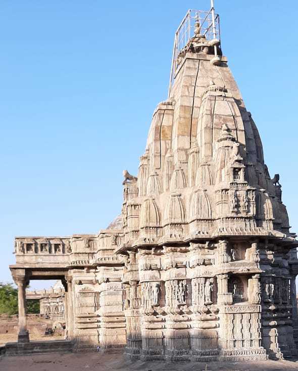
Champaner-Pavagadh Archaeological Park
India · 22.4833° N, 73.5333° E · 13 km² · 41 km from Vadodara
Champaner-Pavagadh Archaeological Park, a UNESCO World Heritage Site, is located in Panchmahal district in Gujarat, India. It is centered around the historic city of Champaner, which was founded by Vanraj Chavda, the most prominent king of the Chavda Dynasty, in the eighth century. He named it after his friend and general, Champa, also known later as Champaraj. The heritage site contains forts with bastions starting from the hills of Pavagadh, and extending into the city of Champaner. The park includes archaeological, historical, and living cultural heritage monuments, including Chalcolithic sites, a hill fortress of an early Hindu capital, and remains of the 16th-century capital of the state of Gujarat. There are palaces, entrance gates and arches, mosques, tombs and temples, residential complexes, agricultural structures and water installations such as stepwells and tanks, dating from the eighth to the 14th centuries. The Kalika Mata Temple, located on top of the 800 metres (2,600 ft) high Pavagadh Hill, is an important Hindu shrine in the region, attracting pilgrims throughout the year.
Adapted from Wikipedia: Champaner-Pavagadh Archaeological Park (CC BY-SA 4.0).
Why Champaner-Pavagadh Archaeological Park Is Listed
- (iii)
- A unique testimony to a cultural tradition or civilisation.
- (iv)
- An outstanding example of a type of building or landscape.
- (v)
- An outstanding example of traditional human settlement or land use.
- (vi)
- A direct association with events, ideas or beliefs of universal significance.
More about Champaner-Pavagadh Archaeological Park
UNESCO's Description
A concentration of largely unexcavated archaeological, historic and living cultural heritage properties cradled in an impressive landscape which includes prehistoric (chalcolithic) sites, a hill fortress of an early Hindu capital, and remains of the 16th-century capital of the state of Gujarat. The site also includes, among other vestiges, fortifications, palaces, religious buildings, residential precincts, agricultural structures and water installations, from the 8th to 14th centuries. The Kalikamata Temple on top of Pavagadh Hill is considered to be an important shrine, attracting large numbers of pilgrims throughout the year. The site is the only complete and unchanged Islamic pre-Mughal city.
From the UNESCO World Heritage Centre (CC BY-SA IGO 3.0).
Geography
The Champaner-Pavagadh heritage site is spread over an area of more than 1,329 hectares (3,280 acres) with a buffer zone of 2,812 hectares (6,950 acres). In addition to the Primary Heritage Zone of 983.27 hectares (2,429.7 acres), there are several other sites which include: Kabutarkhana, Maqbara, Maqbara Mandvi, Maqbara near Patidar Village, Malik Sandal Ni Vav, Hathikhana, Sindh Mata, Sikander Ka Reuza, Babakhan Ki Dargah, Nau Kuan Sat Vavdi, and Chandrakala Vav. The site is 50 kilometres (31 mi) east of Baroda and 68 kilometres (42 mi) south of Godhra, whose history is recorded from the second century AD and which has many religious monuments of Gujarati Sultans (of Turkish descent), Rajputs, and Jains.
History
Judging by early archaeological remains and according to records, the area had already been inhabited in the Chalcolithic period; however, it remained neglected until approximately 400 AD. The history also reports a local legend that the divinity of the hills was derived from the right toe of the goddess Kalika, which had apparently fallen on the hill.
Champaner is named after Champa Bhil, a last Bhil king of Champaner. Champa Bhil built Champaner Fort He also established this city during the rule of Vanraj Chavda of Anhilwad Patan (from 746 to 806 AD). In the eleventh century, Ram Gaur Tuar ruled, and Champaner was under the Anhilwad until 1297 or so when they were defeated by Alauddin Khalji, who made it their stronghold.
Sections adapted from Wikipedia: Champaner-Pavagadh Archaeological Park (CC BY-SA 4.0).
Key Facts
| Area | 13.3 km² |
|---|
Facts from Wikidata Q844427 (CC0).

Chhatrapati Shivaji Maharaj Terminus
India · 18.9398° N, 72.8355° E · 9 km from Mumbai
Chhatrapati Shivaji Terminus (CST), officially Chhatrapati Shivaji Maharaj Terminus (CSMT), and also known as Victoria Terminus (VT), its official name until 1996, is a historic railway terminus and UNESCO World Heritage Site in Mumbai (Bombay), Maharashtra, India.
The terminus was designed by a British architectural engineer Frederick William Stevens from an initial design by Axel Haig, in an exuberant Indo Gothic style. Its construction began in 1878, in a location south of the old Bori Bunder railway station, and was completed in 1887, the year of Queen Victoria's Golden Jubilee. The station was inaugurated to the general public on 20 May 1888.
In March 1996, the station's official name was changed from Victoria Terminus to Chhatrapati Shivaji Terminus after Shivaji, the 17th-century warrior king and the first Chhatrapati of the Maratha Empire, who founded the polity in the western Marathi-speaking regions of the Deccan Plateau. In 2017, the station was again renamed to Chhatrapati Shivaji Maharaj Terminus (with code CSMT), in which the title Maharaj means "great king" or emperor. The initials VT and CST are commonly used for the station.
Adapted from Wikipedia: Chhatrapati Shivaji Terminus (CC BY-SA 4.0).
Why Chhatrapati Shivaji Maharaj Terminus Is Listed
- (ii)
- An important interchange of human values.
- (iv)
- An outstanding example of a type of building or landscape.
More about Chhatrapati Shivaji Maharaj Terminus
UNESCO's Description
The Chhatrapati Shivaji Terminus, formerly known as Victoria Terminus Station, in Mumbai, is an outstanding example of Victorian Gothic Revival architecture in India, blended with themes deriving from Indian traditional architecture. The building, designed by the British architect F. W. Stevens, became the symbol of Bombay as the ‘Gothic City’ and the major international mercantile port of India. The terminal was built over 10 years, starting in 1878, according to a High Victorian Gothic design based on late medieval Italian models. Its remarkable stone dome, turrets, pointed arches and eccentric ground plan are close to traditional Indian palace architecture. It is an outstanding example of the meeting of two cultures, as British architects worked with Indian craftsmen to include Indian architectural tradition and idioms thus forging a new style unique to Bombay.
From the UNESCO World Heritage Centre (CC BY-SA IGO 3.0).
History
This famous landmark which has become a symbol of the city, was built as the headquarters of the Great Indian Peninsular Railway.
The railway station was built to replace the Bori Bunder railway station, in the Bori Bunder area of Bombay, a prominent port and warehouse area known for its imports and exports. Since Bombay became a major port city at the time, a bigger station was built to meet its demands, and was named Victoria Terminus, after the then reigning Empress of India, Queen Victoria. The station was designed by Frederick William Stevens, a British engineer architect, attached to the Bombay office of the Indian colonial Public Works Department. Work began in 1878. He received ₹1,614,000 (US$17,000) as the payment for his services.
Sections adapted from Wikipedia: Chhatrapati Shivaji Terminus (CC BY-SA 4.0).
Key Facts
| Area | 0 km² |
|---|---|
| Architectural style | Indo-Saracenic architecture, Victorian architecture |
Facts from Wikidata Q235884 (CC0).
Visiting Chhatrapati Shivaji Maharaj Terminus
South Mumbai is one of the most affluent districts of Mumbai. Many of the city's famous landmarks, including the iconic Gateway of India, Taj Mahal Palace Hotel, and Marine Drive (Queen's Necklace) are found here. This area also connects to the nearby Elephanta Caves. Ferries are available from Gateway of India to the island.
Travel notes adapted from Wikivoyage: Mumbai/South (CC BY-SA 4.0).

Jantar Mantar
India · 26.9247° N, 75.8250° E · 2 km from Jaipur
The Jantar Mantar is a collection of 19 astronomical instruments built by the Rajput king Sawai Jai Singh, the founder of Jaipur, Rajasthan, India. The monument was completed in 1734. It features the world's largest stone sundial, and is a UNESCO World Heritage Site. It is near City Palace and Hawa Mahal. The instruments allow the observation of astronomical positions with the naked eye. The observatory is an example of the Ptolemaic positional astronomy which was shared by many civilizations.
The monument features instruments operating in each of the three main classical celestial coordinate systems: the horizon-zenith local system, the equatorial system, and the ecliptic system. The Kanmala Yantraprakara is one that works in two systems and allows the transformation of the coordinates directly from one system to the other. It has the biggest sundial in the world.
The monument was damaged in the 19th century. Early restoration work was undertaken under the supervision of Major Arthur Garrett, a keen amateur astronomer, during his appointment as Assistant State Engineer for the Jaipur District.
Adapted from Wikipedia: Jantar Mantar, Jaipur (CC BY-SA 4.0).
Why Jantar Mantar Is Listed
- (iii)
- A unique testimony to a cultural tradition or civilisation.
- (iv)
- An outstanding example of a type of building or landscape.
More about Jantar Mantar
UNESCO's Description
The Jantar Mantar, in Jaipur, is an astronomical observation site built in the early 18th century. It includes a set of some 20 main fixed instruments. They are monumental examples in masonry of known instruments but which in many cases have specific characteristics of their own. Designed for the observation of astronomical positions with the naked eye, they embody several architectural and instrumental innovations. This is the most significant, most comprehensive, and the best preserved of India's historic observatories. It is an expression of the astronomical skills and cosmological concepts of the court of a scholarly prince at the end of the Mughal period.
From the UNESCO World Heritage Centre (CC BY-SA IGO 3.0).
History
Exactly when Sawai Jai Singh began construction in Jaipur is unknown, but several instruments had been built by 1728, and the construction of the instruments in Jaipur continued until 1738. During 1735, when construction was at its peak, at least 23 astronomers were employed in Jaipur, and due to the changing political climate, Jaipur replaced Delhi as Raja Jai Singh's main observatory and remained Jai Singh's central observatory until his death in 1743. The observatory lost support under Ishwari Singh (r.1743-1750) because of a succession war between him and his brother. However, Madho Singh I (r. 1750–1768), Ishwari Singh's successor, supported the observatory, although it did not see the same level of activity as under Jai Singh.
Description
Chakra Yantra (four semicircular arcs on which a gnomon casts a shadow, thereby giving the declination of the Sun at four specified times of the day. This data corresponds to noon at four observatories around the world (Greenwich in UK, Zurich in Switzerland, Notke in Japan and Saitchen in Pacific); this is equivalent of a wall of clocks registering local times in different parts of the world.)
Shastansh Yantra (next to Vrihat Samrat Yantra) This instrument has a 60-degree arc built in the meridian plane within a dark chamber. At noon, the Sun's pinhole image falls on a scale below enabling the observer to measure the zenith distance, declination, and the diameter of the Sun.)
Filming location
It was used as a filming location for the 2006 film The Fall as a maze.
Storm Thorgerson photographed the sundial for the cover of Shpongle's DVD, Live at the Roundhouse 2008.
It was photographed by Julio Cortázar with the collaboration of Antonio Gálvez for the book Prosa del Observatorio (Editorial Lumen: Barcelona, 1972).
Sections adapted from Wikipedia: Jantar Mantar, Jaipur (CC BY-SA 4.0).
Key Facts
| Established | 18th century |
|---|---|
| Area | 0 km² |
Facts from Wikidata Q508634 (CC0).

Western Ghats
India · 10.1697° N, 77.0611° E · 7,953 km² · 20 km from Valparai
The Western Ghats, also known as the Sahyadri, is a mountain range that stretches 1,600 km (1,000 mi) along the west coast of India. Covering an area of 160,000 km2 (62,000 mi2), it traverses the Indian states of Gujarat, Maharashtra, Goa, Karnataka, Kerala, and Tamil Nadu. The range forms an almost continuous chain of mountains along the western edge of the Deccan Plateau, from the Tapti River to Swamithoppe in Kanyakumari district at the southern tip of the Indian peninsula. The Western Ghats meet with the Eastern Ghats at Nilgiris before continuing south.
Geologic evidence indicates that the mountains were formed during the break-up of the supercontinent of Gondwana. The mountains arose along the west coast of India somewhere in the late Jurassic and early Cretaceous periods when India separated from the African continent. The mountains can be roughly divided into three parts: the northern section with an elevation ranging from 900–1,500 m (3,000–4,900 ft), the middle section starting south of Goa with a lower elevation of less than 900 m (3,000 ft), and the southern section where the altitude rises again.
Adapted from Wikipedia: Western Ghats (CC BY-SA 4.0).
Why Western Ghats Is Listed
- (ix)
- An outstanding example of ongoing ecological and biological processes.
- (x)
- The most important natural habitats for conserving biodiversity.
More about Western Ghats
UNESCO's Description
Older than the Himalaya mountains, the mountain chain of the Western Ghats represents geomorphic features of immense importance with unique biophysical and ecological processes. The site’s high montane forest ecosystems influence the Indian monsoon weather pattern. Moderating the tropical climate of the region, the site presents one of the best examples of the monsoon system on the planet. It also has an exceptionally high level of biological diversity and endemism and is recognized as one of the world’s eight ‘hottest hotspots’ of biological diversity. The forests of the site include some of the best representatives of non-equatorial tropical evergreen forests anywhere and are home to at least 325 globally threatened flora, fauna, bird, amphibian, reptile and fish species.
From the UNESCO World Heritage Centre (CC BY-SA IGO 3.0).
Geography
The Western Ghats extend from the Satpura Range south of the Tapti River in the north and runs approximately 1,600 km (990 mi) to the southern tip of the Indian peninsula, where it ends at the Marunthuvazh Malai at Swamithoppe in Kanyakumari district. It covers an area of 160,000 km2 (62,000 sq mi), traversing the Indian states of Gujarat, Maharashtra, Goa, Karnataka, Kerala, and Tamil Nadu.
The Western Ghats form an almost continuous chain of mountains running parallel to the western coast of India along the Arabian Sea. The average elevation is around 1,200 m (3,900 ft). There are three gaps in the mountain range: the northernmost Goa Gap, formed 65 to 80 million years ago, the oldest and widest Palghat Gap, formed 500 million years ago, and the southernmost narrowest Sengottai Gap.
Geology
The Western Ghats are the mountainous, faulted, and eroded edge of the Deccan Plateau. Geologic evidence indicates that they were formed during the break-up of the super-continent of Gondwana. After the break-up, the Deccan Plateau was formed by basalt rocks, which caused the western side to rise at an elevation.
Geophysical evidence indicates that the mountains arose along the west coast of India somewhere in the late Jurassic and early Cretaceous periods when India separated from the African continent. Several faults triggered the formation of Western Ghats, then interspersed with valleys and river gorges. Because of the elevation of the Deccan Plateau on the west, most rivers flow from west to east, resulting in chiselled eastern slopes and steeper western slopes facing the sea.
Climate
The Western Ghats play an important role in determining the climate and seasons in India. During the dry summer months of April – May, heat builds up on the land, which draws air from the sea. The air, which picks up moisture along the way and flows eastward from the Arabian Sea, is blocked by the Western Ghats. The rising air cools and brings about orographic precipitation along the western coast. This signifies the onset of the monsoon season in June. By the time the air rises above the mountains, it becomes dry, resulting in a rain shadow region with very little rainfall on the leeward side towards the interior of the Deccan plateau.
Sections adapted from Wikipedia: Western Ghats (CC BY-SA 4.0).

Great Himalayan National Park
India · 31.8043° N, 77.9510° E · 905 km² · 108 km from Simla
The Great Himalayan National Park (GHNP) is a national park in India, located in Banjar sub-division of Kullu in the state of Himachal Pradesh. The park was established in 1984 and is spread over an area of 1171 km2; elevations within the park range between 1500 and 6000 m. The Great Himalayan National Park is a habitat to numerous flora and more than 375 fauna species, including approximately 31 mammals, 181 birds, 3 reptiles, 9 amphibians, 11 annelids, 17 mollusks and 127 insects. They are protected under the strict guidelines of the Wildlife Protection Act of 1972; hence any sort of hunting is not permitted.
In June 2014, the Great Himalayan National Park was added to the UNESCO list of World Heritage Sites, under the criterion of "outstanding significance for biodiversity conservation".
Adapted from Wikipedia: Great Himalayan National Park (CC BY-SA 4.0).
Why Great Himalayan National Park Is Listed
- (x)
- The most important natural habitats for conserving biodiversity.
More about Great Himalayan National Park
UNESCO's Description
This National Park in the western part of the Himalayan Mountains in the northern Indian state of Himachal Pradesh is characterized by high alpine peaks, alpine meadows and riverine forests. The 90,540 ha property includes the upper mountain glacial and snow meltwater sources of several rivers, and the catchments of water supplies that are vital to millions of downstream users. The GHNPCA protects the monsoon-affected forests and alpine meadows of the Himalayan front ranges. It is part of the Himalaya biodiversity hotspot and includes twenty-five forest types along with a rich assemblage of fauna species, several of which are threatened. This gives the site outstanding significance for biodiversity conservation.
From the UNESCO World Heritage Centre (CC BY-SA IGO 3.0).
Trekking and tourism
In the recent years, the GHNP has emerged as a popular trekking and ecotourism destination. The GHNP office at Sai Ropa issues permits for the treks. There are several popular trekking routes in the park, ranging from those that can be done in a day or two, to those that can take up from a week to ten days. Ecotourism and homestay tourism has also being gaining popularity in places outside but near to the park.
Sections adapted from Wikipedia: Great Himalayan National Park (CC BY-SA 4.0).
Key Facts
| Established | 1984 |
|---|---|
| Area | 755 km² |
Facts from Wikidata Q1544213 (CC0).

Rani ki vav
India · 23.8589° N, 72.1016° E · 83 km from Gandhinagar
Rani ki Vav (lit. 'The Queen's Stepwell') is a stepwell situated in the town of Patan in Gujarat, India. It is located on the banks of the Saraswati River. Its construction is attributed to Udayamati, the spouse of the 11th-century Chaulukya king Bhima I. Silted over, it was rediscovered in the 1940s and restored in the 1980s by the Archaeological Survey of India. It has been listed as a UNESCO World Heritage Sites in India since 2014. The stepwell is designed as an underground shrine or inverted temple symbolizing the sanctity of water, with sculptures depicting numerous Hindu deities. It is divided into seven stair levels, each with sculptural panels. These panels contain more than 500 principal sculptures and over a thousand minor ones, combining religious, secular, and symbolic imagery.
Adapted from Wikipedia: Rani ki Vav (CC BY-SA 4.0).
Why Rani ki vav Is Listed
- (i)
- A masterpiece of human creative genius.
- (iv)
- An outstanding example of a type of building or landscape.
More about Rani ki vav
UNESCO's Description
Rani-ki-Vav, on the banks of the Saraswati River, was initially built as a memorial to a king in the 11th century AD. Stepwells are a distinctive form of subterranean water resource and storage systems on the Indian subcontinent, and have been constructed since the 3rd millennium BC. They evolved over time from what was basically a pit in sandy soil towards elaborate multi-storey works of art and architecture. Rani-ki-Vav was built at the height of craftsmens’ ability in stepwell construction and the Maru-Gurjara architectural style, reflecting mastery of this complex technique and great beauty of detail and proportions. Designed as an inverted temple highlighting the sanctity of water, it is divided into seven levels of stairs with sculptural panels of high artistic quality; more than 500 principle sculptures and over a thousand minor ones combine religious, mythological and secular imagery, often referencing literary works. The fourth level is the deepest and leads into a rectangular tank 9.5 m by 9.4 m, at a depth of 23 m. The well is located at the westernmost end of the property and consists of a shaft 10 m in diameter and 30 m deep.
From the UNESCO World Heritage Centre (CC BY-SA IGO 3.0).
History
Rani ki Vav was constructed during the rule of the Chaulukya dynasty. It is located on the banks of the Saraswati River. The city was sacked by Sultan of Delhi Qutb-ud-din Aibak between 1200 and 1210, and again by Allauddin Khilji in 1298.
Prabandha-Chintamani, composed by the Jain monk Merutunga in 1304, mentions: "Udayamati, the daughter of Naravaraha Khengara, built this novel stepwell at Shripattana (Patan) surpassing the glory of the Sahasralinga Tank". According to it, the stepwell was commissioned in 1063 and was completed after 20 years. It is generally assumed that it was built in the memory of Bhima I (r. c. 1022 – 1064) by his queen Udayamati and probably completed by Udayamati and Karna after his death, but whether she was a dowager when she commissioned it is disputed.
Sections adapted from Wikipedia: Rani ki Vav (CC BY-SA 4.0).

Khangchendzonga National Park
India · 27.6563° N, 88.3123° E · 1,784 km² · 47 km from Gangtok
Khangchendzonga National Park is a national park and part of the Khangchendzonga Biosphere Reserve in Sikkim, India. It was inscribed to the UNESCO World Heritage Sites list in July 2016, becoming the first "Mixed Heritage" site of India. It was included in the UNESCO Man and the Biosphere Programme. The park is named after the mountain Kangchenjunga, which is the third-highest peak in the world at 8,586 m (28,169 ft) tall. The total area of the park is 1,784 km2 (689 sq mi).
Adapted from Wikipedia: Khangchendzonga National Park (CC BY-SA 4.0).
Why Khangchendzonga National Park Is Listed
- (iii)
- A unique testimony to a cultural tradition or civilisation.
- (vi)
- A direct association with events, ideas or beliefs of universal significance.
- (vii)
- Superlative natural phenomena or exceptional natural beauty.
- (x)
- The most important natural habitats for conserving biodiversity.
More about Khangchendzonga National Park
UNESCO's Description
Located at the heart of the Himalayan range in northern India (State of Sikkim), the Khangchendzonga National Park includes a unique diversity of plains, valleys, lakes, glaciers and spectacular, snow-capped mountains covered with ancient forests, including the world’s third highest peak, Mount Khangchendzonga. Mythological stories are associated with this mountain and with a great number of natural elements (caves, rivers, lakes, etc.) that are the object of worship by the indigenous people of Sikkim. The sacred meanings of these stories and practices have been integrated with Buddhist beliefs and constitute the basis for Sikkimese identity.
From the UNESCO World Heritage Centre (CC BY-SA IGO 3.0).
Geography
Khangchendzonga National Park covers an area of 1,784 km2 (689 sq mi) in Mangan district and Gyalshing district at an elevation of 1,829 m (6,001 ft) to over 8,550 m (28,050 ft). It is one of the few high-altitude national parks of India and was designated as a mixed-criteria UNESCO World Heritage Site in July 2016.
In the north, it adjoins Qomolangma National Nature Preserve in Tibet, and in the west Kanchenjunga Conservation Area in Nepal.
Sections adapted from Wikipedia: Khangchendzonga National Park (CC BY-SA 4.0).
Key Facts
| Established | 1977 |
|---|---|
| Area | 1,784 km² |
Facts from Wikidata Q2605019 (CC0).

Nalanda Mahavihara
India · 25.1368° N, 85.4438° E · 58 km from Gaya
Nalanda (IAST: Nālandā, pronounced [naːlən̪d̪aː]) was a renowned Buddhist mahavihara (great monastery) in medieval Magadha (modern-day Bihar), eastern India. Widely considered to be among the greatest centres of learning in the ancient world and often referred to as "the world's first residential university", it was located near the city of Rajagriha (now Rajgir), roughly 90 kilometres (56 mi) southeast of Pataliputra (now Patna). Operating for almost a thousand years from 427 CE until around 1400 CE, Nalanda mahavihara played a vital role in promoting the patronage of arts, culture and academics during the 5th and 6th century CE, a period that has since been described as the "Golden Age of India" by scholars. The characterisation of Nalanda as a "university" in the modern sense has been challenged by scholars. They argue that while it was undoubtedly a major centre of learning, comparing it directly to a modern university is historically imprecise.
Nalanda was established by emperor Kumaragupta I of the Gupta Empire around 427 CE, and was supported by numerous Indian and Javanese patrons – both Buddhists and non-Buddhists.
Adapted from Wikipedia: Nalanda mahavihara (CC BY-SA 4.0).
Why Nalanda Mahavihara Is Listed
- (iv)
- An outstanding example of a type of building or landscape.
- (vi)
- A direct association with events, ideas or beliefs of universal significance.
More about Nalanda Mahavihara
UNESCO's Description
The Nalanda Mahavihara site is in the State of Bihar, in north-eastern India. It comprises the archaeological remains of a monastic and scholastic institution dating from the 3rd century BCE to the 13th century CE. It includes stupas , shrines, viharas (residential and educational buildings) and important art works in stucco, stone and metal. Nalanda stands out as the most ancient university of the Indian Subcontinent. It engaged in the organized transmission of knowledge over an uninterrupted period of 800 years. The historical development of the site testifies to the development of Buddhism into a religion and the flourishing of monastic and educational traditions.
From the UNESCO World Heritage Centre (CC BY-SA IGO 3.0).
History
Archaeological excavations at sites near Nalanda, such as the Juafardih site about three kilometres away, have yielded black ware and other items. These have been carbon dated to about 1200 BCE. This suggests that the region around Nalanda in Magadha had a human settlement centuries before the birth of the Mahavira and the Buddha.
Early Buddhist texts state that Buddha visited a town near Rajagriha (modern Rajgir – the capital of Magadha) called Nalanda on his peregrinations. He delivered lectures in a nearby mango grove named Pavarika and one of his two chief disciples, Shariputra, was born in the area and later attained nirvana there. These Buddhist texts were written down centuries after the death of the Buddha, are not consistent in either the name or the relative locations.
Location
Nalanda is about 16 kilometres (10 mi) north of the city of Rajgir and about 90 kilometres (56 mi) southeast of Patna, connected via NH 31, 20 and 120 to India's highway network. It is about 80 kilometres (50 mi) northeast of Bodh Gaya – another important Buddhist site in Bihar. The Nalanda archaeological site is spread over a large area to the northwest of Bargaon (Nalanda) village, and is between the historical manmade lakes Gidhi, Panashokar and Indrapuskarani. On the south bank of the Indrapushkarani lake is the Nava Nalanda Mahavihara – a university founded in its memory. Similarly on the south west bank of the Indrapushkarani lake is Nalanda Open University, the state university named after the ancient Nalanda University.
Tourism
Nalanda is a popular tourist destination in the state attracting a number of Indian and overseas visitors. It is also an important stop on the Buddhist tourism circuit.
The Archaeological Survey of India maintains a museum near the ruins for the benefit of visitors. The museum, opened in 1917, exhibits the antiquities that have been unearthed at Nalanda as well as from nearby Rajgir. Out of 13,463 items, only 349 are on display in four galleries.
The Xuanzang Memorial Hall is an Indo-Chinese undertaking to honour the famed Buddhist monk and traveller. A relic, comprising a skull bone of the Chinese monk, is on display in the memorial hall.
Another museum adjoining the excavated site is the privately run Nalanda Multimedia Museum.
Sections adapted from Wikipedia: Nalanda mahavihara (CC BY-SA 4.0).

Historic City of Ahmadabad
India · 23.0256° N, 72.5875° E · 5 km² · 1 km from Ahmedabad
The Historic City of Ahmadabad or Old Ahmedabad, the walled city of Ahmedabad in India, was founded by Ahmad Shah I of the Gujarat Sultanate in 1411. It remained the capital of the state of Gujarat for six centuries and later became the important political and commercial centre of Gujarat. Today, despite having become crowded and dilapidated, it still serves as the symbolic heart of metropolitan Ahmedabad. It was inscribed as a World Heritage City by UNESCO in July 2017.
Adapted from Wikipedia: Historic City of Ahmadabad (CC BY-SA 4.0).
Why Historic City of Ahmadabad Is Listed
- (ii)
- An important interchange of human values.
- (v)
- An outstanding example of traditional human settlement or land use.
More about Historic City of Ahmadabad
UNESCO's Description
The walled city of Ahmadabad, founded by Sultan Ahmad Shah in the 15th century, on the eastern bank of the Sabarmati river, presents a rich architectural heritage from the sultanate period, notably the Bhadra citadel, the walls and gates of the Fort city and numerous mosques and tombs as well as important Hindu and Jain temples of later periods. The urban fabric is made up of densely-packed traditional houses ( pols ) in gated traditional streets ( puras ) with characteristic features such as bird feeders, public wells and religious institutions. The city continued to flourish as the capital of the State of Gujarat for six centuries, up to the present.
From the UNESCO World Heritage Centre (CC BY-SA IGO 3.0).
History
The earliest settlements were situated south of the current old city and on the bank of Sabarmati River. It was known as Ashaval or Ashapalli. In the 11th century, Karna of the Chaulukya dynasty made the town his capital and named it Karnavati (Karna's town), Shrinagar (prosperous city), and Rajnagar (king's town).
Ahmed Shah I laid the foundation of Bhadra Fort starting from Manek Burj, the first bastion of the city in 1411 which was completed in 1413. He also established the first square of the city, Manek Chowk, both associated with the legend of Hindu saint Maneknath. His Gujarat Sultanate (1411–1573) ruled from the city until 1484. His grandson Mahmud Begada transferred capital from Ahmedabad to Muhammadabad from 1484 to 1535 but carried out second fortification of the city.
Sections adapted from Wikipedia: Historic City of Ahmadabad (CC BY-SA 4.0).

Victorian Gothic and Art Deco Ensembles of Mumbai
India · 18.9298° N, 72.8301° E · 1 km² · 10 km from Mumbai
The Victorian Gothic and Art Deco Ensembles of Mumbai is a collection of 19th-century Victorian Revival public and 20th-century Mumbai Art Deco private buildings in the Fort precinct of Mumbai. This ensemble was declared a UNESCO World Heritage Site in 2018.
These buildings are set around the Oval Maidan, a large recreational ground that was once known as the Esplanade. The east of the Oval is flanked by the Victorian Gothic public buildings and the western side is flanked by the Art Deco buildings of Back bay Reclamation and Marine Drive. This nomination aims to safeguard a total of 94 buildings.
The 19th century Victorian Gothic buildings that lie to the east of the Oval are mainly the Bombay High Court, The University of Mumbai (Fort Campus) and The City Civil and Sessions Court (Housed in the Old Secretariat Building). This stretch also houses one of the landmarks of Mumbai, the Rajabai Clock Tower. The 20th century Art Deco buildings flank the western stretch of the Oval and consist mainly of privately owned residential buildings and the Eros Cinema among others.
Adapted from Wikipedia: Victorian Gothic and Art Deco Ensembles of Mumbai (CC BY-SA 4.0).
Why Victorian Gothic and Art Deco Ensembles of Mumbai Is Listed
- (ii)
- An important interchange of human values.
- (iv)
- An outstanding example of a type of building or landscape.
More about Victorian Gothic and Art Deco Ensembles of Mumbai
UNESCO's Description
Having become a global trading centre, the city of Mumbai implemented an ambitious urban planning project in the second half of the 19th century. It led to the construction of ensembles of public buildings bordering the Oval Maidan open space, first in the Victorian Neo-Gothic style and then, in the early 20th century, in the Art Deco idiom. The Victorian ensemble includes Indian elements suited to the climate, including balconies and verandas. The Art Deco edifices, with their cinemas and residential buildings, blend Indian design with Art Deco imagery, creating a unique style that has been described as Indo-Deco . These two ensembles bear testimony to the phases of modernization that Mumbai has undergone in the course of the 19th and 20th centuries.
From the UNESCO World Heritage Centre (CC BY-SA IGO 3.0).
Key Facts
| Area | 0.7 km² |
|---|
Facts from Wikidata Q16942531 (CC0).

Jaipur
India · 26.9150° N, 75.8200° E · 7 km² · 1 km from Jaipur
Jaipur (Rajasthani: Jayapura, pronounced [ˈd͡ʑɛpʊɾᵊ]) is the capital and the largest city of the north-western Indian state of Rajasthan. As of 2011, the city had a population of 3.1 million, making it the tenth most populous city in the country. Located 268 km (167 miles) from the national capital New Delhi, Jaipur is also known as the Pink City due to the dominant colour scheme of its buildings in the old city.
Jaipur was founded in 1727 by Sawai Jai Singh II, the Kachhwaha Rajput ruler of Amer, after whom the city is named. It is one of the earliest planned cities of modern India, designed by Vidyadhar Bhattacharya. During the British colonial period, the city served as the capital of Jaipur State. After Indian independence in 1947, Jaipur became the capital of the newly formed state of Rajasthan in 1949.
Jaipur is a popular tourist destination in India, forming a part of the Western Golden Triangle tourist circuit along with Delhi and Agra. The city serves as a gateway to other tourist destinations in Rajasthan, such as Jodhpur, Jaisalmer, Bikaner, Udaipur, Bundi, Kota, and Mount Abu; it has three World heritage sites, Amer Fort, Hawa Mahal and Jantar Mantar.
Adapted from Wikipedia: Jaipur (CC BY-SA 4.0).
Why Jaipur Is Listed
- (ii)
- An important interchange of human values.
- (iv)
- An outstanding example of a type of building or landscape.
- (vi)
- A direct association with events, ideas or beliefs of universal significance.
More about Jaipur
UNESCO's Description
The walled city of Jaipur, in India’s north-western state of Rajasthan was founded in 1727 by Sawai Jai Singh II. Unlike other cities in the region located in hilly terrain, Jaipur was established on the plain and built according to a grid plan interpreted in the light of Vedic architecture. The streets feature continuous colonnaded businesses that intersect in the centre, creating large public squares called chaupars . Markets, shops, residences and temples built along the main streets have uniform facades. The city's urban planning shows an exchange of ideas from ancient Hindu and early modern Mughal as well as Western cultures. The grid plan is a model that prevails in the West, while the organization of the different city sectors (chowkris) refers to traditional Hindu concepts. Designed to be a commercial capital, the city has maintained its local commercial, artisanal and cooperative traditions to this day.
From the UNESCO World Heritage Centre (CC BY-SA IGO 3.0).
Geography
Jaipur is located in the northeastern part of Rajasthan and covers a total area of 467 square kilometres (180 sq mi). The city is surrounded by fertile alluvial plains to the east and south, and hill chains and desert areas to the north and west. Jaipur generally slopes downwards from north to south and then to the southeast. The city is surrounded by the Nahargarh hills in the north and Jhalana in the east, which is a part of the Aravalli range.
The Dravyavati River is the primary drainage channel, which by 2014 had degenerated into an untreated sewage nallah. To address this issue, a plan for the rejuvenation of the river was developed by Jaipur Development Authority (JDA) in 2015.
History
Jaipur was founded by the Rajput chief of Kachhwaha clan, Jai Singh II, on 18 November 1727, who ruled the region from 1699 to 1743. He planned to shift his capital from Amber, 11 kilometres (7 mi) to Jaipur to accommodate the growing population and increasing scarcity of water. Jai Singh consulted several architects while planning the layout of Jaipur and established the city based on the principles of Vastu Shastra and Shilpa Shastra, under the architectural guidance of Vidyadhar Bhattacharya. The construction of the city began in 1726. During the rule of Sawai Ram Singh II, the city was painted pink to welcome Albert Edward, Prince of Wales in 1876. Many of the avenues remain painted in pink, giving Jaipur a distinctive appearance and the epithet Pink City.
Economy
As per the official records released by the Directorate of Economics and Statistics (Rajasthan), the GDP (nominal) of Jaipur district is estimated at INR 1,22,140 crores ($15.8 billion) in 2020–21, with a per-capita GDP of INR 141,305. In addition to its role as the provincial capital, educational, and administrative centre, the economy of Jaipur is fuelled by tourism, gemstone cutting, the manufacture of jewellery and luxury textiles, and information technology.
Three major trade promotion organisations have their offices in Jaipur: Federation of Indian Chambers of Commerce & Industry, (FICCI) the PHD Chamber of Commerce and Industry (PHDCCI) and the Confederation of Indian Industry (CII) which has its regional offices here.
Sections adapted from Wikipedia: Jaipur (CC BY-SA 4.0).
Visiting Jaipur
Jaipur (Hindi: जयपुर Jaypur), also known as the Pink City, is the capital of Indian state of Rajasthan, and its largest city. The city was built in the 18th century by Sawai Jai Singh as India's first planned city, and today it's a major tourist attraction for Indians and for international visitors. It is a very picturesque city with splendid palaces, forts and historical monuments and belongs to the tourist Golden Triangle along with Delhi and Agra. It hosts several attractions including the City Palace, Govind Dev ji Temple, Vidhan Sabha, Birla Temple and several massive Rajput forts. It also serves as a stepping stone for those heading to the desert cities of Jodhpur and Jaisalmer.
Jaipur is growing fast and various development projects are being undertaken by the government and private enterprises.
Jaipur's nickname, the Pink City, is due to its distinctly coloured buildings, which were painted this colour to imitate the red sandstone architecture of Mughal cities.
Travel notes adapted from Wikivoyage: Jaipur (CC BY-SA 4.0).

Dholavira
India · 23.8861° N, 70.2167° E · 1 km² · 82 km from Bhuj
Dholavira (Gujarati: ધોળાવીરા, IPA: [d̪ʰoɭaʋiɾaː]) is an archaeological site at Khadirbet in Bhachau Taluka of Kutch District, in the state of Gujarat, western India, which is named after a modern-day village 1 kilometre (0.62 mi) south of it. This village is 165 km (103 mi) from Radhanpur. Also known locally as Kotada timba, the site contains ruins of a city of the ancient Indus Valley Civilization. Earthquakes have repeatedly affected Dholavira, including a particularly severe one around 2600 BCE.
Adapted from Wikipedia: Dholavira (CC BY-SA 4.0).
Why Dholavira Is Listed
- (iii)
- A unique testimony to a cultural tradition or civilisation.
- (iv)
- An outstanding example of a type of building or landscape.
More about Dholavira
UNESCO's Description
The ancient city of Dholavira, the southern centre of the Harappan Civilization, is sited on the arid island of Khadir in the State of Gujarat. Occupied between ca. 3000-1500 BCE, the archaeological site, one of the best preserved urban settlements from the period in Southeast Asia, comprises a fortified city and a cemetery. Two seasonal streams provided water, a scarce resource in the region, to the walled city which comprises a heavily fortified castle and ceremonial ground as well as streets and houses of different proportion quality which testify to a stratified social order. A sophisticated water management system demonstrates the ingenuity of the Dholavira people in their struggle to survive and thrive in a harsh environment. The site includes a large cemetery with cenotaphs of six types testifying to the Harappan’s unique view of death. Bead processing workshops and artifacts of various kinds such as copper, shell, stone, jewellery of semi-precious stones, terracotta, gold, ivory and other materials have been found during archaeological excavations of the site, exhibiting the culture’s artistic and technological achievements. Evidence for inter-regional trade with other Harappan cities, as well as with cities in the Mesopotamia region and the Oman peninsula have also been discovered.
From the UNESCO World Heritage Centre (CC BY-SA IGO 3.0).
Location
Dholavira's location is on the Tropic of Cancer. It is one of the five largest Harappan sites and the most prominent archaeological site in India belonging to the Indus Valley Civilization. It is located on Khadir Bet island in the Kutch Desert Wildlife Sanctuary in the Great Rann of Kutch. The 47 ha (120 acres) quadrangular city lay between two seasonal streams, the Mansar in the north and Manhar in the south. The site is believed to have been occupied from c. 2650 BCE, declining slowly after around 2100 BCE, and to have been briefly abandoned then reoccupied until c. 1450 BCE; however, recent research suggests the beginning of occupation around 3500 BCE (pre-Harappan) and continuity until around 1800 BCE (early part of Late Harappan period).
Sections adapted from Wikipedia: Dholavira (CC BY-SA 4.0).
Visiting Dholavira
Dholavira is a small town and archaeological site in Kutch, containing ruins of an ancient Indus Valley Civilisation (Harappan) city. It is a UNESCO World Heritage Site.
Travel notes adapted from Wikivoyage: Dholavira (CC BY-SA 4.0).

Ramappa Temple
India · 18.2594° N, 79.9425° E · 47 km from Warangal
The Rudreshwara Temple, more commonly known as the Ramappa Temple, is a Hindu temple located in the village of Palampet in eastern Telangana, India. An inscription on a basalt pillar found within a nearby courtyard records that the temple was commissioned in 1213 by Recherla Rudra, a military general of the Kakatiya dynasty, and constructed over a period of 40 years during the reign of Ganapati, the third sovereign of the dynasty. Dedicated to the Hindu deity Shiva, it is a prominent example of Kakatiya architecture, and combines elements of Dravidian and Chalukyan architectural styles.
The temple is primarily constructed of red sandstone, with intricately carved pillars and brackets of granite and dolerite. It exhibits several unique architectural features, including a vimana built with lightweight, buoyant clay bricks and a "sandbox"-style foundation designed to absorb the seismic loads generated by earthquakes. The temple suffered minor damage during Malik Kafur's invasion of Warangal in 1310, and its condition significantly deteriorated after the subsequent decline and fall of the Kakatiya dynasty.
Adapted from Wikipedia: Ramappa Temple (CC BY-SA 4.0).
Why Ramappa Temple Is Listed
- (i)
- A masterpiece of human creative genius.
- (iii)
- A unique testimony to a cultural tradition or civilisation.
More about Ramappa Temple
UNESCO's Description
Rudreshwara, popularly known as Ramappa Temple, is located in the village of Palampet approximately 200km north-east of Hyderabad, in the State of Telangana. It is the main Shiva temple in a walled complex built during the Kakatiyan period (1123–1323 CE) under rulers Rudradeva and Recharla Rudra. Construction of the sandstone temple began in 1213 CE and is believed to have continued over some 40 years. The building features decorated beams and pillars of carved granite and dolerite with a distinctive and pyramidal Vimana (horizontally stepped tower) made of lightweight porous bricks, so-called ‘floating bricks’, which reduced the weight of the roof structures. The temple’s sculptures of high artistic quality illustrate regional dance customs and Kakatiyan culture. Located at the foothills of a forested area and amidst agricultural fields, close to the shores of the Ramappa Cheruvu, a Kakatiya-built water reservoir, the choice of setting for the edifice followed the ideology and practice sanctioned in dharmic texts that temples are to be constructed to form an integral part of a natural setting, including hills, forests, springs, streams, lakes, catchment areas, and agricultural lands.
From the UNESCO World Heritage Centre (CC BY-SA IGO 3.0).
Background
In 1199, the Kakatiya ruler Mahadeva was killed in battle during a protracted conflict with Jaitugi of the Seuna dynasty, who subsequently captured and imprisoned Mahadeva's nephew Ganapati. In the following months, Mahadeva's commander-in-chief Recherla Rudra took over the administration of the kingdom and quelled an attempted rebellion by a chieftain of unknown origin named Nagati. Following entreaties by Rudra and other Kakatiya ministers, Ganapati was released by Jaitugi and installed as the ruler of the Kakatiyas after pledging to serve as his vassal. Under the rule of Ganapati, the Kakatiya dynasty reached its greatest territorial extent.
Location
Ramappa temple is located in Palampet, in Venkatapur mandal of Mulugu district. The village lies about 19 kilometres (12 mi) from Mulugu, the district headquarter and about 70 kilometres (43 mi) from Warangal city. The Temple's geographic coordinates are 18°15′32.88″N, 79°56′35.54″E.
The nearest railway station is in Warangal, approximately 70 km from the temple. The nearest airport is in Hyderabad about 150 km away.
Sections adapted from Wikipedia: Ramappa Temple (CC BY-SA 4.0).

Sacred Ensembles of the Hoysalas
India · 13.2125° N, 75.9941° E · 93 km from Shimoga
The Sacred Ensembles of the Hoysalas is a group of three Hoysala-style temples in South India recognized as a World Heritage Site. These temples at Somanathapura, Belur and Halebidu, were built between the 12th and 13th centuries under the Hoysala Empire. The three temples under the title of the Sacred Ensembles of the Hoysalas were inscribed on the UNESCO World Heritage List in 2023, for their outstanding architecture, hyper-realistic sculptures and stone carvings.
The architectural style of the three temples was developed by the early Hoysala rulers – who established their new kingdoms and regimes in South India – as a distinctive and innovative sacred architecture, which distinguishes the temples from contemporary kingdoms and dynasties. These temples are as follows:
Chennakeshava Temple in Belur (built by King Vishnuvardhana).
Hoysaleswara Temple in Halebidu (built by King Vishnuvardhana).
Keshav Temple in Somanathapura (built by Somanatha under King Narasimha III).
Adapted from Wikipedia: Sacred Ensembles of the Hoysalas (CC BY-SA 4.0).
Why Sacred Ensembles of the Hoysalas Is Listed
- (i)
- A masterpiece of human creative genius.
- (ii)
- An important interchange of human values.
- (iv)
- An outstanding example of a type of building or landscape.
More about Sacred Ensembles of the Hoysalas
UNESCO's Description
This serial property encompasses the three most representative examples of Hoysala-style temple complexes in southern India, dating from the 12th to 13th centuries. The Hoysala style was created through careful selection of contemporary temple features and those from the past to create a different identity from neighbouring kingdoms. The shrines are characterized by hyper-real sculptures and stone carvings that cover the entire architectural surface, a circumambulatory platform, a large-scale sculptural gallery, a multi-tiered frieze, and sculptures of the Sala legend. The excellence of the sculptural art underpins the artistic achievement of these temple complexes, which represent a significant stage in the historical development of Hindu temple architecture.
From the UNESCO World Heritage Centre (CC BY-SA IGO 3.0).
History
The Hoysala dynasty ruled large parts of present-day Karnataka between the 11th and 14th centuries. By the end of the 12th century, they had expanded the agrarian economic system of their kingdom and had also begun to establish taxation, revenue and administrative systems, thus beginning the process of state formation. At the same time, the Hoysala kings made a concerted effort to establish a new and distinct identity for their kingdom through patronage of art, architecture and literature. As a result, a new form of temple architecture developed, combining superior carving and superior decoration with innovative temple planning. This architectural style synthesized and combined architectural features prevalent in different parts of the country with original elements in innovative ways.
Location
The Sacred Ensembles of the Hoysalas is located in three places in two districts of Karnataka, there are two temples in Hassan district and one temple in Mysore district.
The Chennakeshava Temple is located in Belur, about 35 kilometers (22 mi) northwest of Hassan town, the headquarter of Hassan district. The temple is about 16 kilometers (9.9 mi) away from Halebidu Temple. The nearest airport to the temple is Bangalore Airport, from which it is a 220 km (137 mi) long drive of about 3.5 hours on National Highway 75 heading west. The Hoysaleswara Temple is located in Halebidu town in Hassan district of Karnataka state. It is about 30 km (19 ma) north-west of Hassan and about 16 km (9.9 ma) from Belur temple.
Sections adapted from Wikipedia: Sacred Ensembles of the Hoysalas (CC BY-SA 4.0).
Key Facts
| Area | 0.1 km² |
|---|
Facts from Wikidata Q66023123 (CC0).

Santiniketan
India · 23.6776° N, 87.6852° E · 51 km from Barddhaman
Santiniketan (IPA: [ʃantiniketɔn]) is a neighbourhood of Bolpur town in the Bolpur subdivision of Birbhum district in West Bengal, India, approximately 152 km north of Kolkata. It was established by Debendranath Tagore, and later expanded by his son, Rabindranath Tagore whose vision became what is now a university town with the creation of Visva-Bharati. It is also the birthplace of Indian Nobel Laureate Amartya Sen, who was also an alumnus of the school.
It was inscribed on the UNESCO World Heritage List by the World Heritage Committee in 2023.
Adapted from Wikipedia: Santiniketan (CC BY-SA 4.0).
Why Santiniketan Is Listed
- (iv)
- An outstanding example of a type of building or landscape.
- (vi)
- A direct association with events, ideas or beliefs of universal significance.
More about Santiniketan
UNESCO's Description
Established in rural West Bengal in 1901 by the renowned poet and philosopher Rabindranath Tagore, Santiniketan was a residential school and centre for art based on ancient Indian traditions and a vision of the unity of humanity transcending religious and cultural boundaries. A ‘world university’ was established at Santiniketan in 1921, recognizing the unity of humanity or “Visva Bharati”. Distinct from the prevailing British colonial architectural orientations of the early 20th century and of European modernism, Santiniketan represents approaches toward a pan-Asian modernity, drawing on ancient, medieval and folk traditions from across the region.
From the UNESCO World Heritage Centre (CC BY-SA IGO 3.0).
Climate
The climate of Santiniketan is moderately warm, with summer temperatures at around 35-42 °C (maximum) and winter at 10-15 °C (minimum). Summer is felt for three months, March, April and May. December, January and February are the winter months. June, July, August and September see heavy rainfall, these four months are known as monsoon (rainy season). Santiniketan saw its highest temperature rising 47.0 °C, on 10 June 1966. The lowest temperature ever recorded is 4.9 °C, on 9 January 2013. The annual average temperature is 26.2 °C. About 1480mm of rain falls per year, with 76 days seeing the rain.
The area is classified as an "Aw" (tropical savanna climate) under the Köppen Climate Classification.
History
In 1863, Debendranath Tagore took on permanent lease 20 acres (81,000 m2) of land, with two chhatim (Alstonia scholaris) trees, at an annual payment of Rs. 5, from Bhuban Mohan Sinha, the talukdar in Raipur, Birbhum. He built a guest house there and named it Santiniketan (the abode of peace). Gradually, the whole area came to be known as Santiniketan.
Binoy Ghosh says that Bolpur was a small place in the middle of the 19th century. It grew as Shantiniketan grew. A certain portion of Bolpur was a part of the zamindari of the Sinha family of Raipur. Bhuban Mohan Sinha had developed a small village in the Bolpur area and named it Bhubandanga. It was just opposite Santiniketan in those days. Bhubandanga was the den of a gang of notorious dacoits, who had no compunction in killing people.
Sections adapted from Wikipedia: Santiniketan (CC BY-SA 4.0).
Visiting Santiniketan
Santiniketan or Shantiniketan (Bengali: শান্তিনিকেতন Shāntiniketon) is a university town in central West Bengal, where students of different backgrounds study in open air, under the canopy of a tree. It is deeply associated with the Bengali poet Rabindranath Tagore who developed the town. It is considered the manifestation of a utopian ideal of a community that became a crucible for intellectual and artistic ideas that were to have a decisive impact on 20th-century art, literature, poetry, music and architecture in South Asia. Around 1.2 million people visit Santiniketan for its unique blend of education, culture and nature.
Travel notes adapted from Wikivoyage: Santiniketan (CC BY-SA 4.0).

Maidam
India · 26.9436° N, 94.8750° E · 1 km² · 60 km from Dibrugarh
Frang-Mai-Dam or Moidam for short (Ahom:𑜉𑜩𑜓𑜝𑜪; meaning: Burial of the dead) is a traditional tumulus of the Ahom religion. The royal maidams of Charaideo are listed as UNESCO world heritage site. Today, the people of the four clans namely Mo-Hung, Mo-Cham, Chaodang and Mo-Plong follow the tomb tradition of Ahom religion.
Structurally, a maidam consists of vaults with one or more chambers. The vaults have a domical superstructure that is covered by a hemispherical earthen mound that rises high above the ground with an open pavilion at the peak called chow chali. An octagonal dwarf wall encloses the entire maidam.
Burial is the predominant funeral rite of the Tai people, to which the Ahom people originally belonged. This is opposed to the Hindu system of cremation. After the Ahom kings adopted Hinduism, they chose to bury the ashes in mounds after cremation.
The Ahom community in Assam consider the excavation as an affront to their tradition, because the maidams are associated with the Ahom ancestor worship and the festival of Me-Dam-Me-Phi.
Adapted from Wikipedia: Moidam (CC BY-SA 4.0).
Why Maidam Is Listed
- (v)
- An outstanding example of traditional human settlement or land use.
More about Maidam
UNESCO's Description
Set in the foothills of the Patkai Ranges in eastern Assam, the property contains the royal necropolis of the Tai-Ahom. For 600 years, the Tai-Ahom created moidams (burial mounds) accentuating the natural topography of hills, forests and water, thus forming a sacred geography. Banyan trees and the trees used for coffins and bark manuscripts were planted and water bodies created. Ninety moidams – hollow vaults built of brick, stone or earth – of different sizes are found within the site. They contain the remains of kings and other royals together with grave goods such as food, horses and elephants, and sometimes queens and servants. The Tai-Ahom rituals of “Me-Dam-Me-Phi” and “Tarpan” are practiced at the Charaideo necropolis. While moidams are found in other areas within the Brahmaputra Valley, those found at the property are regarded as exceptional.
From the UNESCO World Heritage Centre (CC BY-SA IGO 3.0).

Maratha Military Landscapes of India
India · 20.7225° N, 73.9425° E · 16 km² · 63 km from Malegaon
The Maratha Military Landscapes of India are a group of 12 forts that were occupied and developed by the Maratha rulers between the 17th and 19th-century. These include Salher, Shivneri Fort, Lohagad, Khanderi, Raigad Fort, Rajgad Fort, Pratapgad, Suvarnadurg, Panhala Fort, Vijaydurg Fort, Sindhudurg Fort, all located in Maharashtra and Gingee Fort in Tamil Nadu. Spread across various geographical terrains, these forts showcase the military prowess of Maratha rule. It was declared as a UNESCO World Heritage Site in 2025.
Adapted from Wikipedia: Maratha Military Landscapes of India (CC BY-SA 4.0).
Why Maratha Military Landscapes of India Is Listed
- (iv)
- An outstanding example of a type of building or landscape.
- (vi)
- A direct association with events, ideas or beliefs of universal significance.
More about Maratha Military Landscapes of India
UNESCO's Description
The property includes twelve major fortifications, mostly in Maharashtra State, with one in Tamil Nadu. These forts, such as Raigad, Shivneri, and Sindhudurg, were built, adapted, or expanded by the Marathas between the late 17th and early 19th centuries. Strategically located on coastal and mountainous terrain, they formed a complex defence system supporting Maratha military dominance, trade protection, and territorial control. This network played a key role in the Marathas’ rise as a major political and military force.
From the UNESCO World Heritage Centre (CC BY-SA IGO 3.0).
Background
In 2021, the Maratha Military Landscapes of India were included in the Tentative World Heritage List. They were then picked as the official nomination from India for inscription in the UNESCO World Heritage List for the year 2024-25, as announced by the Ministry of Culture in January 2024. Maharashtra has more than 390 forts, out of which only 11 forts were selected for this list along with one fort in Tamil Nadu. These forts span across the diverse topographies of the Sahyadri Range, Deccan Plateau, Konkan Coast, and the Eastern Ghats. The Maratha military strategy that involved these forts was developed during the reign of the Maratha ruler Chhatrapati Shivaji Maharaj in the 17th-century and continued till the Peshwa rule in the early 19th-century.
Sections adapted from Wikipedia: Maratha Military Landscapes of India (CC BY-SA 4.0).
Key Facts
| Area | 15.8 km² |
|---|
Facts from Wikidata Q134720951 (CC0).

Sarnath
India · 25.3811° N, 83.0214° E · 6 km from Varanasi
Sarnath (also known as Deer Park, Sarangnath, Isipatana Deer Park, Rishipattana, Migadaya, or Mrigadava) is a town northeast of Varanasi, in Uttar Pradesh, India. It was here that the Buddha gave his first sermon after attaining enlightenment at Bodh Gaya. The Lion Capital of Ashoka, raised on a column in Sarnath in 250 BCE by the first Buddhist emperor Ashoka, commemorates this event. It is also the State Emblem of India.
Sarnath is one of the eight most important pilgrimage sites for Buddhists, and has been declared a UNESCO World Heritage Site, being added to the list in 2026.
Sarnath is where Gautama Buddha's sangha first convened, when he gave the first teaching to his original five disciples Kaundinya, Assaji, Bhaddiya, Vappa and Mahanama, known as The First Turning of the Wheel of Dharma. As the Lalitavistara sutra states, the Gautama Buddha chose "Deer Park by the Hill of the Fallen Sages, outside of Varanasi" for his first teaching after he attained enlightenment The teaching is entitled Dhammacakkappavattana sutra. This teaching occurred circa 528 BCE when the Buddha was approximately 35 years of age.
Adapted from Wikipedia: Sarnath (CC BY-SA 4.0).
Why Sarnath Is Listed
- (iii)
- A unique testimony to a cultural tradition or civilisation.
- (vi)
- A direct association with events, ideas or beliefs of universal significance.
More about Sarnath
UNESCO's Description
The serial property contains the architectural and archaeological remains of Sarnath, the sacred site where the Buddha is believed to have delivered his first sermon in the 6th century BCE and met his earliest disciples. Identified by the Buddha himself as one of the four principal Buddhist pilgrimage sites, Sarnath grew over many centuries through royal, monastic, and lay patronage, resulting in the construction of numerous stupas, temples, and viharas. After flourishing as a major Buddhist centre, Sarnath declined in the 12th century CE and fell into obscurity until its rediscovery in the 18th century. Today preserved as two archaeological zones, it remains both an important tourist destination and a revived pilgrimage site for Buddhists worldwide.
From the UNESCO World Heritage Centre (CC BY-SA IGO 3.0).
History
Buddhism flourished in Sarnath during the second urbanisation, c. 600– 200 BCE, from the time of the Mahajanapadas through the Nanda Empire and Maurya Empire periods, in part because of patronage from kings and wealthy merchants based in Varanasi. By the 3rd century CE, Sarnath had become an important centre for the Sammatiya, one of the early Buddhist schools, as well as for art and architecture.
The presence of Heruka and Tara images in Sarnath indicate that the later school of Vajrayana was also practised there. Hindu images of Shiva and Brahma were present, while a Jain temple was located very close to the Dhamek Stupa.
By the time of the Gupta Empire (4th to 6th centuries), Buddhism had expanded beyond India via the Silk Road.
Sections adapted from Wikipedia: Sarnath (CC BY-SA 4.0).
Visiting Sarnath
Sarnath is a holy town in Uttar Pradesh, India, about 13 km north-east of Varanasi. It's famous as the site of the deer park where Gautama Buddha first taught the Dharma and also where the original Sangha was formed. Consequently, it is one of the 4 main Buddhist pilgrimage destinations, and since 2026 the Chaukandi Stupa and the Archaelogical Remains of Sarnath are listed as a UNESCO World Heritage Site.
Travel notes adapted from Wikivoyage: Sarnath (CC BY-SA 4.0).
World Heritage in India: Quick Answers
- How many UNESCO World Heritage Sites are in India?
- India has 39 World Heritage Sites: 31 cultural, 7 natural and 1 mixed.
- What was the first World Heritage Site in India?
- Agra Fort, inscribed in 1983. The most recent is Sarnath, inscribed in 2026.
- What are the natural World Heritage Sites in India?
- Kaziranga National Park, Kevladev National Park, Manas National Park, Sundarbans National Park, Nanda Devi and Valley of Flowers National Parks, Western Ghats, Great Himalayan National Park, Khangchendzonga National Park (mixed).
- Are any World Heritage Sites in India in danger?
- None of the World Heritage Sites in India is on UNESCO's List of World Heritage in Danger.