Skip to content
YearMaps
Philippines · Islands

Largest Islands of Philippines

Malay Archipelago is the largest of the 14 islands recorded for Philippines, at 3.91M km², ahead of Philippines at 377,943 km². The full list follows.

How this list is built: Ranked by mapped area. An island divided between countries is listed under each, with the area of the whole island. It covers the islands indexed in YearMaps, drawn from open geospatial data, and is not an exhaustive national register.

Islands Listed
14
Top Ranked
3.91M km²
Malay Archipelago
Second
377,943 km²
Philippines
Profiled Below
13
Photo, encyclopedia text and figures
Largest Islands of Philippines
#NameArea
1Malay Archipelago3.91M km²
2Philippines377,943 km²
3Luzon105,881 km²
4Mindanao94,557 km²
5Negros12,943 km²
6Samar12,619 km²
7Panay11,628 km²
8Palawan11,506 km²
9Mindoro9,916 km²
10Sulu Archipelago7,934 km²
11Leyte7,028 km²
12Calamian Group5,286 km²
13Babuyan Islands3,914 km²
14Bohol3,769 km²

The Islands of Philippines in Detail

The 13 islands above that have an encyclopedia article, in the same order, each with its photograph, figures and the places around it.

Philippines
Image via Wikimedia Commons (author and licence on the file page).

Philippines

Island group · 377,943 km²

Philippines is an island group in Asia (Malay Archipelago), covering an estimated 377,943 km². It is the 25th-largest of the 445 islands with a mapped extent in YearMaps.

The Philippines, officially the Republic of the Philippines, is an archipelagic country in Southeast Asia. Located in the western Pacific Ocean, it consists of about 7,641 islands, with a total area of about 300,000 square kilometers. The islands are broadly categorized into three main geographical divisions: from north to south, Luzon, Visayas, and Mindanao. With a population of over 114 million, it is the world's thirteenth-most-populous country.

The Philippines is bounded by the South China Sea to the west, the Philippine Sea to the east, and the Celebes Sea to the south. It shares maritime borders with Taiwan to the north, Japan to the northeast, Palau to southeast, Indonesia to the south, Malaysia to the southwest, Vietnam to the west, and China to the northwest. It has diverse ethnicities and a rich culture. Manila is the country's capital, and its most populated city is Quezon City. Both are within Metro Manila.

Negritos, the archipelago's earliest inhabitants, were followed by waves of Austronesian peoples. The adoption of animism, Hinduism with Buddhist influence, and Islam established island-kingdoms.

Adapted from Wikipedia: Philippines (CC BY-SA 4.0).

Feature class
Island group
Mapped extent
377,943 km²
Size rank
#25 of 445 islands
Region
Asia
Subregion
Malay Archipelago
Coordinates
7.9703°, 120.0269°
Summits:
Mount Mantalingajan (2,085 m), Gunung Kinabalu (4,101 m), Mount Apo (2,954 m)
Ranges:
Dângrêk Range (Asia), Wuyi Mountains (Asia)
Settlements:
Puerto Princesa (243 km), Zamboanga (254 km), Sandakan (318 km)

View on the live map

More about Philippines

Geography

The Philippines is an archipelago of approximately 7,641 islands, covering a total area (including inland bodies of water) of about 300,000 square kilometers (115,831 sq mi). Stretching 1,850 kilometers (1,150 mi) north to south, from the South China Sea to the Celebes Sea, the Philippines is bordered by the Philippine Sea to the east, and the Sulu Sea to the southwest. The Luzon Strait is the most economical (quickest) traffic node for shipping between the Americas and Asia.

It is also a critical junction of Asia-Pacific-Americas undersea communication cables. The country's 11 largest islands are Luzon, Mindanao, Samar, Negros, Palawan, Panay, Mindoro, Leyte, Cebu, Bohol and Masbate, about 95 percent of its total land area.

History

There is evidence of early hominins living in what is now the Philippines as early as 709,000 years ago. Bones from Callao Cave potentially represent an otherwise unknown species, Homo luzonensis, who lived 50,000 to 67,000 years ago. The oldest modern human remains on the islands are from the Tabon Caves of Palawan, U/Th-dated to 47,000 ± 11–10,000 years ago. Tabon Man is presumably a Negrito, among the archipelago's earliest inhabitants descended from the first human migrations out of Africa via the coastal route along southern Asia to the now-sunken landmasses of Sundaland and Sahul.

The first Austronesians reached the Philippines from Taiwan around 2200 BC, settling the Batanes Islands (where they built stone fortresses known as ijangs) and northern Luzon.

Demographics

In July 2024, the Philippines had a population of 112,729,484. More than 60 percent of the country's population live in the coastal zone. In 2020, 54 percent lived in urban areas. Manila, its capital, and Quezon City, the country's most populous city, are in Metro Manila. About 13.48 million people, 12 percent of the Philippines' population, live in Metro Manila, the country's most populous metropolitan area and the world's fifth most populous. Between 1948 and 2010, the population of the Philippines increased almost fivefold, from 19 million to 92 million.

The country's median age is 25.3, and 63.9 percent of its population is between 15 and 64 years old.

Economy

According to the International Monetary Fund (IMF) in its October 2025 update, the Philippines is the world's 33rd largest economy with a nominal gross domestic product (GDP) of $494.16 billion. As a newly industrialized country, the Philippine economy has been transitioning from an agricultural base to one with more emphasis on services and manufacturing. The country's labor force is about 52.09 million with an unemployment rate of 5.1 percent as of February 2026. Gross international reserves totalled US$106.64 billion as of March 2026.

Sections adapted from Wikipedia: Philippines (CC BY-SA 4.0).

Philippines: Key Facts

Key facts about Philippines
Area343,448 km²
Population112,729,484 (2024)
Highest pointMount Apo
Surrounded byWest Philippine Sea, Philippine Sea

Facts from Wikidata Q928 (CC0).

Visiting Philippines

The Philippines (Filipino: Pilipinas), officially the Republic of the Philippines (Republika ng Pilipinas), is an archipelago of more than 7,100 islands in Southeast Asia.

The country has one of the world's longest coastlines with many fine beaches and excellent diving. There is great cultural diversity due to the many islands, many waves of immigration, and a mixture of foreign influences — the country has been trading with nearby nations for several thousand years and was a Spanish colony from 1562 to 1898, then American until 1946. It would take decades to visit and experience everything.

Many locals speak English well and a lot of the others have at least some English. Food and accommodations are cheap, many destinations have excellent infrastructure, and the people are cheerful and friendly; perhaps the easiest way to recognize a Filipino abroad is to see who has the broadest smile.

Travel notes adapted from Wikivoyage: Philippines (CC BY-SA 4.0).

Luzon
Image via Wikimedia Commons (author and licence on the file page).

Luzon

Island · 105,881 km²

Luzon is an island in Asia (Malay Archipelago), covering an estimated 105,881 km².

Luzon ( loo-ZON, Tagalog: [luˈson]) is the largest and most populous island in the Philippines. Located in the northern portion of the Philippine archipelago, it is the economic and political center of the nation. The country's capital city, Manila, as well as Quezon City, the country's most populous city, are located on the island of Luzon. Luzon has a population of 64.3 million as of 2024; this constitutes more than half of the total population of the Philippines. Luzon is the 4th most populous island in the world. It is the 15th largest island in the world by area of land.

Luzon may also refer to one of the three primary island groups in the country. In this usage, it includes the Luzon Mainland, the Batanes and Babuyan groups of islands to the north, Polillo Islands to the east, and the outlying islands of Catanduanes, Marinduque and Mindoro, among others, to the south. The islands and provinces of Masbate, Palawan and Romblon are also included, although these three are sometimes grouped with another of the island groups, the Visayas.

Adapted from Wikipedia: Luzon (CC BY-SA 4.0).

Feature class
Island
Mapped extent
105,881 km²
Size rank
#57 of 445 islands
Region
Asia
Subregion
Malay Archipelago
Coordinates
16.9445°, 121.3934°
Summits:
Pulog (2,934 m), Mount Pinatubo (1,486 m), Taal Volcano (400 m)
Ranges:
Wuyi Mountains (Asia), Dabie Mountains (Asia)
Settlements:
Tuguegarao (82 km), Baguio City (105 km), Vigan (128 km)

View on the live map

More about Luzon

Geography

Luzon island alone has an area of 109,964.9 square kilometres (42,457.7 sq mi), making it the world's 15th largest island. It is bordered on the west by the South China Sea (Luzon Sea in Philippine territorial waters), on the east by the Philippine Sea, and on the north by the Luzon Strait containing the Babuyan Channel and Balintang Channel. The mainland is roughly rectangular in shape and has the long Bicol Peninsula protruding to the southeast.

Luzon is roughly divided into four sections; Northern Luzon, Central Luzon, Southern Luzon, and Metro Manila.

Northern Luzon consists of 3 clusters in three regions, the Ilocos Region, the Cordillera Administrative Region and the Cagayan Valley.

History

Homo luzonensis fossils, found in Callao Cave on Luzon, represent a newly identified extinct archaic human species from at least 50,000 to 67,000 years ago.

Before 1000 CE, the Tagalog, Kapampangan, and Pangasinan peoples of south and central Luzon had established several major coastal polities, notably Maynila, Tondo and Namayan. The oldest known Philippine document, written in 900, is the Laguna Copperplate Inscription, which names places in and around Manila Bay and also mentions Medan, a place in Indonesia. These coastal Philippine kingdoms were thalassocracies, based on trade with neighboring Asian political entities and structured by leases between chiefs or lords (Datu) and paramount lords (Lakan) or Rajahs, by whom tributes were extracted and taxes were levied.

Demographics

As of the 2024 census, the population of Luzon Island itself is 59,865,193 people, making it the 4th most populated island in the world.

Metro Manila is the most populous of the 3 defined metropolitan areas in the Philippines and the 11th most populous in the world. as of 2007, census data showed it had a population of 11,553,427, comprising 13 percent of the national population. Including suburbs in the adjacent provinces (Bulacan, Cavite, Laguna, and Rizal) of Greater Manila, the population is around 21 million.

Seven major Philippine ethnolinguistic groups predominate Luzon. Ilocanos and Pangasinenses dominate northern Luzon, particularly in the Ilocos Region to parts of the Cagayan Valley, while Kapampangans, Tagalogs, Ilocanos, Pangasinans and Sambals populate Central Luzon.

Economy

The economy of the island is centered in Metro Manila with Makati serving as the main economic and financial hub. Major companies such as Ayala, Jollibee Foods Corporation, SM Group, and Metrobank are based in the business hubs of Makati Central Business District, Ortigas Center, and Bonifacio Global City. Industry is concentrated in and around the urban areas of Metro Manila while agriculture predominates in the other regions of the island producing crops such as rice, bananas, mangoes, coconuts, pineapple, and coffee.

Sections adapted from Wikipedia: Luzon (CC BY-SA 4.0).

Luzon: Key Facts

Key facts about Luzon
Area109,965 km²
Population53,336,134 (2015)
Highest pointMount Pulag
Surrounded byPacific Ocean

Facts from Wikidata Q125384 (CC0).

Mindanao
Image via Wikimedia Commons (author and licence on the file page).

Mindanao

Island · 94,557 km²

Mindanao is an island in Asia (Malay Archipelago), covering an estimated 94,557 km².

Mindanao ( , MIN-də-NOW) is the second-largest island in the Philippines, after Luzon, and seventh-most populous island in the world. Located in the southern region of the archipelago, the island is part of an island group of the same name that also includes its adjacent islands, notably the Sulu Archipelago. According to the 2020 census, Mindanao had a population of 26,252,442, while the entire island group had an estimated population of 27,384,138 as of 2024.

Mindanao is divided into six administrative regions: the Zamboanga Peninsula, Northern Mindanao, the Caraga region, the Davao region, Soccsksargen, and the autonomous region of Bangsamoro. According to the 2020 census, Davao City is the most populous city on the island, with 1,776,949 people, followed by Zamboanga City (pop. 977,234), Cagayan De Oro (pop. 728,402), General Santos (pop. 722,059), Butuan (pop. 372,910), and Cotabato City (pop. 325,079).

Adapted from Wikipedia: Mindanao (CC BY-SA 4.0).

Feature class
Island
Mapped extent
94,557 km²
Size rank
#59 of 445 islands
Region
Asia
Subregion
Malay Archipelago
Coordinates
8.0914°, 125.4621°
Summits:
Mount Apo (2,954 m), Mount Halcon (2,585 m), Taal Volcano (400 m)
Ranges:
Maoke Mountains (Oceania), Wuyi Mountains (Asia)
Settlements:
Cagayan de Oro (94 km), Butuan (96 km), Davao (110 km)

View on the live map

More about Mindanao

Geography

Mindanao is the second-largest island in the Philippines at 97,530 square kilometres (37,660 sq mi), and is the seventh-most populous island in the world. The island is mountainous, and is home to Mount Apo, the highest mountain in the country. Mindanao is surrounded by four seas: the Sulu Sea to the west, the Philippine Sea to the east, the Celebes Sea to the south, and the Mindanao Sea to the north.

The island itself is part of an island group of the same name, which consists of the mainland, the Sulu Archipelago and the outlying islands of Camiguin, Dinagat, Siargao, and Samal.

The mountains of Mindanao can be grouped into ten ranges, including both complex structural mountains and volcanoes.

History

Archaeological findings on the island point to evidence of human activity dating back about ten thousand years. Around 1500 BC, Austronesian people spread throughout the Philippines.

The Subanon are believed to have settled in the Zamboanga Peninsula during the Neolithic era c. 4500–2000 BC. Evidence of stone tools in Zamboanga del Norte may indicate a late Neolithic presence. Ceramic burial jars, both unglazed and glazed, Chinese celadons, gold ornaments, beads, and bracelets have been found in caves. Many of the ceramic objects are from the Yuan and Ming periods. Evidently, there was a long history of trade between the Subanon and the Chinese.

Demographics

In 2017, Mindanao had a population of over 25 million. This represented 22 percent of the entire population of the country.

An American census conducted in the early 1900s noted that the island was inhabited by people "greatly divided in origin, temperament and religion". Evidence of the island's cultural diversity can be seen in the buildings and ruins of old Spanish settlements in the northwestern peninsula that span eastwards to the southern gulf coast, the site of the ancient Rajahnate of Butuan in the northeast region (Caraga), the sultanates in the southwest (Sultanate of Sulu, Sultanate of Lanao, Sultanate of Maguindanao), a number of Buddhist and Taoist temples, and the numerous indigenous tribes.

Economy

Mindanao's economy accounts for 14% of the country's gross domestic product. The region grew 4.9% in 2016 against Luzon's 5.5% and Visayas' 9.1%.

Agriculture, forestry and fishing make up more than 40% of Mindanao's market, being the country's largest supplier of major crops such as pineapples and bananas.

There is one defined growth corridor in the island, namely Metro Davao. Other growth centers are: Cagayan de Oro, General Santos, Zamboanga City, Cotabato City, and Pagadian City.

Being the top-performing economy in Mindanao, Davao Region has the 5th-biggest economy in the country and the second-fastest-growing economy next to Cordillera Autonomous Region.

Sections adapted from Wikipedia: Mindanao (CC BY-SA 4.0).

Mindanao: Key Facts

Key facts about Mindanao
Area97,530 km²
Population27,021,036 (2021)
Highest pointMount Apo
Surrounded byPhilippine Sea, Celebes Sea

Facts from Wikidata Q124873 (CC0).

Negros
Image via Wikimedia Commons (author and licence on the file page).

Negros

Island · 12,943 km²

Negros is an island in Asia (Malay Archipelago), covering an estimated 12,943 km².

Negros (English: , UK: , Tagalog: [ˈnegɾos]) is the fourth largest and third most populous island in the Philippines, with a total land area of 13,309 km2 (5,139 sq mi). The coastal zone of the southern part of Negros is identified as a site of highest marine biodiversity importance in the Coral Triangle.

Negros is one of the many islands of the Visayas, in the central part of the country. The predominant inhabitants of the island region are mainly called Negrenses (locally Negrosanons). As of 2024 census, the total population of Negros is 4,797,302

people. This puts it among the 25 most populous islands in the world, close in population to Sicily or Bali.

From 2015 to 2017, the whole island was governed as an administrative region officially named the Negros Island Region, which comprised the highly urbanized city of Bacolod and the provinces of Negros Occidental and Negros Oriental, along with its corresponding outlying islands and islets within a total regional area of 13,350.74 km2 (5,154.75 sq mi). It was created on May 29, 2015, by virtue of Executive Order No. 183 issued by President Benigno Aquino III.

Adapted from Wikipedia: Negros (CC BY-SA 4.0).

Feature class
Island
Mapped extent
12,943 km²
Size rank
#132 of 445 islands
Region
Asia
Subregion
Malay Archipelago
Coordinates
9.6890°, 122.8172°
Summits:
Mount Apo (2,954 m), Mount Halcon (2,585 m), Taal Volcano (400 m)
Ranges:
Wuyi Mountains (Asia), Maoke Mountains (Oceania)
Settlements:
Bacolod (106 km), Iloilo (117 km), Cebu (138 km)

View on the live map

More about Negros

Geography

Negros is the second largest island in the Visayas (after Samar) and the fourth largest of the Philippines, with a total land area of 13,309.6 square kilometres (5,138.9 sq mi), similar to Flores or Jamaica. It is located between the islands of Panay and Guimaras to the west and Cebu to the east, with Siquijor located on the toe of the island and the islands of Bantayan to the north. Politically and linguistically, Negros is divided into two provinces: Negros Occidental and Negros Oriental.

This division of the island, which roughly follows the mountain range in the center of the island, corresponds to the two related linguistic groups.

History

Negros was originally called Buglas, an old Hiligaynon word thought to mean "cut off", as the island was thought to have been separated from a larger landmass. It was also known as Mamaylan and Panilougon among Cebuano-speaking Visayans. Among its earliest inhabitants were the aboriginal Ata, one of several Negrito Indigenous Peoples dispersed throughout Southeast Asia that possesses a unique culture. The westernmost portions of the island soon fell under the nominal rule of the Kedatuan of Madja-as based on the neighboring islands of Panay and Guimaras, while the eastern coasts were influenced by the Rajahnate of Cebu from the adjacent island of Cebu.

Economy

Negros is noted for being the nation's prime producer and exporter of sugar. Sugarcane plantations abound in the agricultural areas of the island. The island also produces cotton and hardwood. Sugar is the biggest industry in the island, followed by organic agricultural products and gamefowl breeding. Its principal sugar-growing region is located in the north and west of the island, stretching from northwest along the coasts of the Visayan Sea and Guimaras Strait, which is one of the nation's principal lowland areas in the Visayas. Negros is now aiming to be the prime producer of organic agricultural produce in Asia.

Sugar refining has many by-products such as acetylene, fertilizers and rum. Fishing is the major industry based in Cadiz.

Tourism

Negros has a lot of tourist attractions. In the city of Silay alone, there are 30 ancestral houses, amongst the most notable is the Balay Negrense. Festivals are also a major tourist attraction in Negros. Among the most notable is the Masskara Festival in the city of Bacolod, which is celebrated during the third week of October, as well as Buglasan Festival in the city of Dumaguete, also held in October. Museums showcase the culture, history and people of Negros, with one example being the Negros Museum, situated behind the Negros Occidental Provincial Capitol Complex.

Sections adapted from Wikipedia: Negros (CC BY-SA 4.0).

Negros: Key Facts

Key facts about Negros
Area13,075 km²
Population4,414,131 (2015)
Highest pointKanlaon Volcano
Surrounded bySulu Sea, Bohol Sea

Facts from Wikidata Q212777 (CC0).

Visiting Negros

Negros (pronounced: NEHG-rawss) is a large island in the Visayas, the island group that forms roughly the central third of the Philippines.

The island-region is known for being the main producer of sugar and organic products in the nation, and is home to many beaches and some nature reserves (some still rarely visited), as well as the tallest peak of the Visayas, the semi-active Kanlaon Volcano. In some cities and towns, especially in Bacolod and to the cities north of it, are several historic landmarks, such as ancestral houses once owned by prominent native families. In the south of the island is Dumaguete, a hip university city that attracts both locals and foreigners alike. Negros is also famous for its several native cultural events, the most popular being the MassKara Festival, which is annually celebrated every October. Negros is also known as one of the top culinary destinations of the Philippines because of its regional cuisine, which is famous for delectable desserts and delicacies and various other dishes.

Travel notes adapted from Wikivoyage: Negros (CC BY-SA 4.0).

Samar
Image via Wikimedia Commons (author and licence on the file page).

Samar

Island · 12,619 km²

Samar is an island in Asia (Malay Archipelago), covering an estimated 12,619 km².

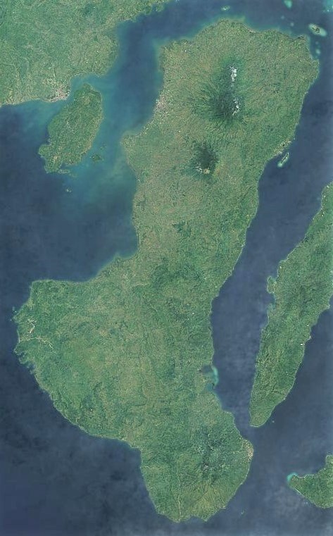
Samar ( SAH-mar) is the third-largest island in the Philippines. It has a population of 1,924,651 as of the 2024 census. It is located in the Eastern Visayas region of the Visayas islands. Since 1965, the island is divided into three provinces: Western Samar, Northern Samar, and Eastern Samar. The capitals of these provinces are, respectively, Catarman, Catbalogan, and Borongan. In commemoration of the establishment of these provinces, June 19 is celebrated as an annual holiday. Its main language and ethnicity is Waray and its main religion is Roman Catholic.

The first European sighting of the island was by Ferdinand Magellan on March 16, 1521. Although he did not land, other expeditions were made. Many names, such as Samal, Ibabao, and Tandaya, were given to the island prior to the arrival of the Spaniards in 1596. During the early days of Spanish occupation, Samar was under the jurisdiction of Cebu. Late in the Philippine–American War, months after the dissolution of the First Philippine Republic, Eugenio Daza led a successful attack against the United States Army, which was followed by the Pacification of Samar and the deaths of over 2,000 people.

Adapted from Wikipedia: Samar (CC BY-SA 4.0).

Feature class
Island
Mapped extent
12,619 km²
Size rank
#133 of 445 islands
Region
Asia
Subregion
Malay Archipelago
Coordinates
12.2016°, 124.9878°
Summits:
Mount Halcon (2,585 m), Taal Volcano (400 m), Mount Apo (2,954 m)
Ranges:
Wuyi Mountains (Asia), Maoke Mountains (Oceania)
Settlements:
Calbayog (44 km), Tacloban (106 km), Ormac (133 km)

View on the live map

More about Samar

Geography

Samar is the third-largest island in the Philippines by area, after the islands of Luzon and Mindanao. Mount Huraw is Samar's highest point, with an elevation of 2,920 ft (890 m). Samar is the easternmost island in the Visayas. It lies to the northeast of Leyte, separated from it by the San Juanico Strait. The island lies to the southeast of the Bicol Peninsula on Luzon, separated from it by the San Bernardino Strait. To the west is the Samar Sea, and to the north and east of Samar lies the Philippine Sea. The island is hilly yet has lower altitude than the mountainous terrain in the rest of the Visayas. Lowlands are mostly found near the coast and along rivers; the rivers themselves are small and flow in a radial pattern.

History

Samar was originally led by prominent datus. Among the documented datus are the following: Datu Iberein from Laoang, Northern Samar; Datu Tandaya from Sulat, Eastern Samar; Datu Hadi from Palapag, Northern Samar; and Datu Binatak from Binatac, Southern Samar.

Samar was the first island of the Philippines as a Spanish colony. An expedition led by Ferdinand Magellan revealed the island, originally transcribed Zamal in the journal of Antonio Pigafetta, to Europeans. He sighted it on March 16, 1521, traveling from the Mariana Islands. Having found an archipelago, Pigafetta named the islands San Lazaro (transl. Saint Lazarus) due to their sightings on Lazarus Saturday. Eventually, Filipinas was the perceived name for the archipelago.

Demographics

As of the 2024 census, the population of the island's three provinces was 1,924,651. The main language in all three provinces of Samar Island is Waray. The second most popular language in Samar province is Bisaya, while the second most popular in Eastern Samar and Northern Samar is Cebuano. Samar province and Northern Samar both have a scale of 0.13 in the Linguistic diversity index while Eastern Samar has a scale of 0.02. Many people in the island are part of the Waray people: in Eastern Samar, 97.78 percent of people were Waray while in Samar, 91.45 classified themselves as Waray. Other ethnic groups include Bisaya, Cebuano, and Tagalog. Males were more populated in both provinces than women.

Economy

The island has a major copra industry: of the six provinces in Eastern Visayas, all three of the Samar provinces were placed in the top four based on copra production, just behind Leyte. Western Samar's industry recorded a 6.1 percent increase from 2018 to 2023. The top three industries in the province are food service activities, transportation, and electricity, steam, water, and waste management. As of 2023, the gross domestic product of the province is PHP 61.35 billion. The island has rice and root crops, including sweet potatoes and cassava. Abacá and dairy from native carabaos are found in the island.

Sections adapted from Wikipedia: Samar (CC BY-SA 4.0).

Samar: Key Facts

Key facts about Samar
Area13,429 km²
Population1,751,267 (2010)
Surrounded byPhilippine Sea, Samar Sea

Facts from Wikidata Q219737 (CC0).

Panay
Image via Wikimedia Commons (author and licence on the file page).

Panay

Island · 11,628 km²

Panay is an island in Asia (Malay Archipelago), covering an estimated 11,628 km².

Panay is the sixth-largest and fourth-most populous island in the Philippines, with a total land area of 12,011 km2 (4,637 sq mi) and a total population of 4,669,037 as of 2024 census, similar to Sicily or Bali. Panay comprises 4.4 percent of the entire population of the country. The City of Iloilo is its largest settlement, with a total population of 473,728 inhabitants as of the 2024 census.

Panay is a triangular island, located in the western part of the Visayas. It is about 160 km (99 mi) across. It is divided into four provinces: Aklan, Antique, Capiz, and Iloilo, all in the Western Visayas Region. Just off the mid-southeastern coast lies the island-province of Guimaras. It is located southeast of the island of Mindoro and northwest of Negros across the Guimaras Strait. To the north and northeast is the Sibuyan Sea, Jintotolo Channel and the island-provinces of Romblon and Masbate; to the west and southwest is the Sulu Sea and the Palawan archipelago and to the south is Panay Gulf. Panay is the only main island in the Visayas whose provinces does not bear the name of their island.

Panay is bisected by the Central Panay Mountain Range, its longest mountain chain.

Adapted from Wikipedia: Panay (CC BY-SA 4.0).

Feature class
Island
Mapped extent
11,628 km²
Size rank
#140 of 445 islands
Region
Asia
Subregion
Malay Archipelago
Coordinates
11.1649°, 122.4457°
Summits:
Mount Halcon (2,585 m), Taal Volcano (400 m), Mount Pinatubo (1,486 m)
Ranges:
Wuyi Mountains (Asia), Dângrêk Range (Asia)
Settlements:
Iloilo (52 km), Roxas (57 km), Bacolod (83 km)

View on the live map

More about Panay

Geography

Panay island is the sixth largest island in the Philippines by area, with a total land area of 12,011 km2 (4,637 sq mi), similar to Jamaica or Samar. Mount Madja-as is the highest point in Panay with an elevation of 2,117 metres (6,946 ft) above sea level, located in town of Culasi in the northern province of Antique. Central Panay Mountain Range is the longest and largest mountain range in the island with a total length of 170 km (110 mi) north-south. Panay River is the longest river in the island with a total length of 169 km (105 mi) located in the province of Capiz.

Boracay Island, a popular tourist destination known for its long white sand shore, is located 0.86 km (0.53 mi; 0.46 nmi) off the northwest tip of Panay Island.

History

No pre-Hispanic written accounts of Iloilo and Panay island exist today. Oral traditions, in the form of recited epics like the Hinilawod, have survived to a small degree. A few recordings of these epic poems exist. The most notable are the works of noted Filipino anthropologist Felipe Jocano.

While no current archaeological evidence exists describing pre-Hispanic Panay, an original work by Pedro Alcantara Monteclaro published in 1907 called Maragtas details the alleged accounts of the founding of the various pre-Hispanic polities on Panay Island. The book is based on oral and written accounts available to the author at the time. The author made no claim for the historical accuracy of the accounts.

Demographics

Panay is the most ethnically and linguistically diverse major island in the Visayas, being native to four vibrant non-indigenous ethnolinguistic groups (Hiligaynon/Ilonggo, Karay-a, Capiznon, Aklanon), and two indigenous groups (Suludnon, Ati) or minorities. However, the ethnic and linguistic boundaries within the island do not correspond to its administrative divisions. Only the province of Antique is monolingual, which only speaks Kinaray-a as its primary language. The lingua franca of the island is Hiligaynon, native to Iloilo City and the northeastern coastal strip lining the province of Iloilo. For local administrative, educational, and commercial purposes, English and Tagalog are also widely used.

Sections adapted from Wikipedia: Panay (CC BY-SA 4.0).

Panay: Key Facts

Key facts about Panay
Area12,011 km²
Population4,477,247 (2015)
Highest pointMount Madia-as
Surrounded bySulu Sea, Visayan Sea

Facts from Wikidata Q332359 (CC0).

Visiting Panay

Panay is an island in the Philippines, the most northwesterly of the Visayas island group. It is to the northwest of the larger island of Negros, and easily accessible with a short ferry ride from Bacolod.

The small island province of Guimaras is in the strait between Panay and Negros and is generally reached by ferry from Iloilo City.

Travel notes adapted from Wikivoyage: Panay (CC BY-SA 4.0).

Palawan
Image via Wikimedia Commons (author and licence on the file page).

Palawan

Island · 11,506 km²

Palawan is an island in Asia (Malay Archipelago), covering an estimated 11,506 km².

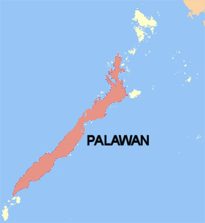
Palawan (Spanish: Isla de La Paragua) is the largest island of the province of Palawan in the Philippines and fifth-largest by area and tenth-most populous island of the country, with a total population of 1,023,849 as of 2024 census. The northwest coast of the island is along the Palawan Passage in the eastern South China Sea, while the southeast coast forms part of the northern limit of the Sulu Sea. Much of the island remains traditional and is considered by some as under-developed. Abundant wildlife, jungle mountains, and some white sandy beaches attract many tourists, as well as international companies looking for development opportunities.

One city and 12 out of the 23 municipalities of the Province of Palawan are on this island. Iwahig Prison and Penal Farm, one of seven operating units of the Bureau of Corrections, is located on the island.

Adapted from Wikipedia: Palawan (island) (CC BY-SA 4.0).

Feature class
Island
Mapped extent
11,506 km²
Size rank
#142 of 445 islands
Region
Asia
Subregion
Malay Archipelago
Coordinates
8.9115°, 117.7583°
Summits:
Mount Mantalingajan (2,085 m), Gunung Kinabalu (4,101 m), Bukit Pagon (1,850 m)
Ranges:
Dângrêk Range (Asia), Wuyi Mountains (Asia)
Settlements:
Puerto Princesa (143 km), Sandakan (343 km), Kota Kinabalu (373 km)

View on the live map

More about Palawan

Geography

The entire length of the island forms a mountain range, with a peak altitude of 2,086 meters (6,844 ft) at Mount Mantalingajan. Other significant peaks include Mount Gantung (1,788 meters (5,866 ft)) in Batazara and Victoria Peak (1,726 meters (5,663 ft)) in Narra. The outlying islands include Cagayancillo to the far east, Dumaran Island and the more distant Cuyo Archipelago are to the northeast, and Linapacan and Busuanga Island nearby in the north-northeast. The archipelago of Kalayaan Municipality is to the far west, while Balabac Municipality is south of the island's western edge.

The geology of Palawan is, in many ways, unlike other parts of the Philippines.

History

The 1818 Spanish census showed, that when Palawan was then called the "Isla de Paragua" and was under the jurisdiction of the Calamianes islands to the north, the census recorded Palawan island to have had 4,486 native families and 29 Spanish-Filipino families.

In April 2013, a fishing vessel loaded with illegally poached animals ran aground on a coral atoll off the coast of Palawan Island.

In May 2014, Armed Forces of the Philippines Chief-of-Staff General Emmanuel T. Bautista commented that Oyster Bay may be developed into a naval base with United States Navy support.

Sections adapted from Wikipedia: Palawan (island) (CC BY-SA 4.0).

Palawan: Key Facts

Key facts about Palawan
Area12,189 km²
Population886,308 (2015)
Highest pointMount Mantalingajan
Surrounded bySulu Sea, South China Sea

Facts from Wikidata Q1061269 (CC0).

Mindoro
Image via Wikimedia Commons (author and licence on the file page).

Mindoro

Island · 9,916 km²

Mindoro is an island in Asia (Malay Archipelago), covering an estimated 9,916 km².

Mindoro is the seventh largest and eighth-most populous island in the Philippines. With a total land area of 10,571 km2 ( 4,082 sq.mi ), it has a population of 1,430,921, as of the 2024 census. It is located off the southwestern coast of Luzon and northeast of Palawan. Mindoro is divided into two provinces: Occidental Mindoro and Oriental Mindoro. Calapan is the only city on the island and largest settlement on the island with a total population of 148,558 inhabitants as of 2024. The southern coast of Mindoro forms the northeastern extremum of the Sulu Sea. Mount Halcon is the highest point on the island, standing at 8,484 feet (2,586 m) above sea level located in Oriental Mindoro. Mount Baco is the island's second highest mountain with an elevation of 8,163 feet (2,488 m), located in the province of Occidental Mindoro.

Adapted from Wikipedia: Mindoro (CC BY-SA 4.0).

Feature class
Island
Mapped extent
9,916 km²
Size rank
#154 of 445 islands
Region
Asia
Subregion
Malay Archipelago
Coordinates
12.9626°, 121.1282°
Summits:
Mount Halcon (2,585 m), Taal Volcano (400 m), Mount Pinatubo (1,486 m)
Ranges:
Wuyi Mountains (Asia), Dângrêk Range (Asia)
Settlements:
Batangas (92 km), San Pablo (125 km), Pasay City (177 km)

View on the live map

More about Mindoro

Geography

Mindoro is the seventh (7th) largest island in the Philippines. It is divided into the provinces of Occidental Mindoro and Oriental Mindoro. The Mindoro Mountain Range is the largest and longest mountain range in the island, with a total length of 200 km (120 mi) north-south and 58 km (36 mi) width east–west. Mount Halcon, at 8,484 feet (2,586 meters), is the island’s highest point and is located in Oriental Mindoro.

Mindoro is a center of biodiversity in the Philippines, a megadiverse country, and has a large number of species found nowhere else in the archipelago. Mindoro additionally hosts its own ecoregion, the Mindoro rain forests, separate from neighboring Luzon.

History

In precolonial times, the island had been called Ma-i or Mait by Han Chinese traders. Indigenous groups are called Mangyans. The Spaniards called the place Mina de Oro ("gold mine"), from where the island derives the current form of its current name. According to the late historian William Henry Scott, an entry in the official history of the Song Dynasty for the year 972 mentions Ma-i as a state which traded with China. Other Chinese records referring to Ma-i or Mindoro appear in the following years.

The products that Mindoro traders exchanged with the Chinese included “beeswax, cotton, true pearls, tortoiseshell, medicinal betelnuts and yu-ta [jute?] cloth” for Chinese porcelain, trade gold, iron pots, lead, copper, colored glass beads and iron needles.

Economy

The economy of Mindoro is largely based on agriculture. Products consist of a wide variety of fruits, such as citrus, bananas, lanzones, rambutan and coconuts, grains (rice and corn), sugarcane, peanuts, fish (catfish, milkfish and tilapia), livestock and poultry. Logging and the mining of marble and copper also thrived. Only 5% of the original forest remains as a result of extensive logging, prevalent agricultural practices, and population growth.

Tourism is a lucrative business as well, with locations such as Apo Reef National Park, Lubang Island, Puerto Galera, Sabang Beach and Mount Halcon. Puerto Galera's beaches are the island's most-known tourist attraction and are widely visited.

Sections adapted from Wikipedia: Mindoro (CC BY-SA 4.0).

Mindoro: Key Facts

Key facts about Mindoro
Area10,572 km²
Population1,331,473 (2015)
Highest pointMount Halcon
Surrounded bySouth China Sea, Sulu Sea

Facts from Wikidata Q211800 (CC0).

Visiting Mindoro

Mindoro is an unspoiled island that's within easy reach from Manila. The town of Puerto Galera in Oriental Mindoro province is a popular tourist destination with many beach and entertainment facilities.

Travel notes adapted from Wikivoyage: Mindoro (CC BY-SA 4.0).

Sulu Archipelago
Image via Wikimedia Commons (author and licence on the file page).

Sulu Archipelago

Island group · 7,934 km²

Sulu Archipelago is an island group in Asia (Malay Archipelago), covering an estimated 7,934 km².

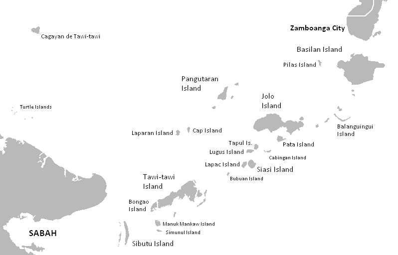
The Sulu Archipelago (Tausug: Kapū'-pūan sin Sūg; Sulat Sūg: كَفُوْءْفُوْأَنْ سِنْ سُوْݢْ; Filipino: Kapuluan ng Sulu) is a chain of islands in the Pacific Ocean in the southwestern Philippines. The archipelago forms the northern limit of the Celebes Sea and southern limit of the Sulu Sea.

The Sulu Archipelago islands are within the Mindanao island group, consisting of the Philippines provinces of Basilan, Sulu, and Tawi-Tawi; hence, the archipelago is sometimes referred to as Basulta, derived from the first syllables of the three provinces.

The archipelago is not, as is often supposed, the remains of a land bridge between Borneo and the Philippines. Rather, it is the exposed edge of small submarine ridges produced by tectonic tilting of the sea bottom. Basilan, Jolo, Tawi-Tawi and other islands in the group are extinct volcanic cones rising from the southernmost ridge. Tawi-Tawi, the southernmost island of the group, has a serpentine basement-complex core with a limestone covering. This island chain is an important migration route for birds.

The largest municipalities in the area are on the island of Jolo.

Adapted from Wikipedia: Sulu Archipelago (CC BY-SA 4.0).

Feature class
Island group
Mapped extent
7,934 km²
Size rank
#166 of 445 islands
Region
Asia
Subregion
Malay Archipelago
Coordinates
5.9729°, 120.2419°
Summits:
Gunung Kinabalu (4,101 m), Mount Mantalingajan (2,085 m), Mount Apo (2,954 m)
Ranges:
Maoke Mountains (Oceania), Dângrêk Range (Asia)
Settlements:
Zamboanga (229 km), Lahad Datu (235 km), Sandakan (236 km)

View on the live map

More about Sulu Archipelago

History

The Sulu Archipelago was once part of Majapahit and is mentioned in the Old Javanese eulogy of Nagarakretagama as Solot. Afterwards, it became part of the Bruneian Sultanate (1368–1888), but gained its independence in 1578. Many Tausugs and other native Muslims of Sulu Archipelago already interacted with Kapampangan and Tagalog Muslims called Luzones based in Brunei, and there were intermarriages between them.

The region then became part of the independent Sultanate of Sulu, founded in 1405. The arrival of Western powers later became a source of conflict when the Spanish began to impose rule over the Spanish East Indies. Spanish military expeditions against the sultanate were launched over the centuries of the Spanish colonial period in the Philippines.

Sections adapted from Wikipedia: Sulu Archipelago (CC BY-SA 4.0).

Sulu Archipelago: Key Facts

Key facts about Sulu Archipelago
Area4,068 km²

Facts from Wikidata Q1061195 (CC0).

Visiting Sulu Archipelago

The Sulu Islands are a region of the Philippines, an island chain that stretches from near Zamboanga City, at the southwestern tip of Mindanao, almost to the Malaysian province of Sabah, at the eastern end of Borneo. Politically, they are part of the Philippines but culturally they are close to Malaysia and Indonesia; in particular, they are almost entirely Muslim.

The Sultanate of Sulu lasted from 1405 to 1915; at its peak it included all of these islands plus Palawan, Sabah, and parts of mainland Mindanao. It was largely a pirate kingdom, and Jolo, in Sulu, had the largest slave market in Asia.

Travel notes adapted from Wikivoyage: Sulu Islands (CC BY-SA 4.0).

Leyte
Image via Wikimedia Commons (author and licence on the file page).

Leyte

Island · 7,028 km²

Leyte is an island in Asia (Malay Archipelago), covering an estimated 7,028 km².

Leyte ( LAY-tee, LAY-tay, Tagalog: [ˈleite]) is an island in the Visayas group of islands in the Philippines. It is eighth-largest and sixth-most populous island in the Philippines, with a total population of 2,626,970 as of the 2020 census. It is among the world's 35 most populous islands, with a similar population to Jamaica or Zealand.

Since the accessibility of land has been depleted, Leyte has provided countless number of migrants to Mindanao.

Most inhabitants are farmers. Fishing is a supplementary activity. Rice and corn (maize) are the main food crops; cash crops include coconuts, abaca, tobacco, bananas, and sugarcane. There are some manganese deposits, and sandstone and limestone are quarried in the northwest.

Politically, the island is divided into two provinces: (Northern) Leyte and Southern Leyte. Territorially, Southern Leyte includes the island of Panaon to its south. To the north of Leyte is the island province of Biliran, a former sub-province of Leyte.

The major cities of Leyte are Tacloban, on the eastern shore at the northwest corner of Leyte Gulf, and Ormoc, on the west coast.

Leyte today is notable for the geothermal electric power plants near Ormoc.

Adapted from Wikipedia: Leyte (CC BY-SA 4.0).

Feature class
Island
Mapped extent
7,028 km²
Size rank
#172 of 445 islands
Region
Asia
Subregion
Malay Archipelago
Coordinates
11.1216°, 124.8148°
Summits:
Mount Apo (2,954 m), Mount Halcon (2,585 m), Taal Volcano (400 m)
Ranges:
Wuyi Mountains (Asia), Maoke Mountains (Oceania)
Settlements:
Ormac (23 km), Tacloban (25 km), Calbayog (108 km)

View on the live map

More about Leyte

Geography

The island measures about 180 kilometres (110 mi) north-south and about 65 kilometres (40 mi) at its widest point, giving it an area of 7,368 km2 (2,845 sq mi), putting Leyte among the world's 100 largest islands, with a size similar to Zealand or Prince Edward Island. In the north it nearly joins the island of Samar, separated by the San Juanico Strait, which becomes as narrow as 2 kilometres (1.2 mi) in some places. The island province of Biliran is also to the north of Leyte and is joined to Leyte island by a bridge across the narrow Biliran Strait. To the south, Leyte is separated from Mindanao by the Surigao Strait.

History

The island was known to 16th-century Spanish explorers as Tandaya. Its population grew rapidly after 1900, especially in the Leyte and Ormoc valleys. The island was once the location of Mairete, a historic community which was ruled by Datu Ete. Before being colonized by Spain, the island was once home to indigenous animist Warays to the east and other indigenous animist Visayan groups to the west. In the early 17th Century Father Ignacio Alcina, recorded a local epic that a certain Datung Sumanga of Leyte courted the princess, Bugbung Humasanum of Bohol by raiding Imperial China, and upon their marriage, they were the precursors of a kingdom there.

Sections adapted from Wikipedia: Leyte (CC BY-SA 4.0).

Leyte: Key Facts

Key facts about Leyte
Area7,368 km²
Population2,388,518 (2015)
Highest pointCabalian Volcano
Surrounded byLeyte Gulf, Visayan Sea

Facts from Wikidata Q211377 (CC0).

Visiting Leyte

Leyte is an island in the Eastern Visayas island group in the Philippines. It is divided into two provinces, Leyte Province and Southern Leyte. Each province includes some nearby smaller islands. Leyte is connected by bridges across narrow straits to the larger Samar Island and to the smaller Biliran island. The two largest cities are the capital, Tacloban, on the east coast near Samar Island, and Ormoc on the western coast.

Travel notes adapted from Wikivoyage: Leyte Island (CC BY-SA 4.0).

Calamian Group
Image via Wikimedia Commons (author and licence on the file page).

Calamian Group

Island group · 5,286 km²

Calamian Group is an island group in Asia (Malay Archipelago), covering an estimated 5,286 km².

The Calamian Islands or the Calamianes is a group of islands in the province of Palawan, Philippines. The archipelago comprises the islands of Coron, Culion, Busuanga, and Linapacan, along with numerous smaller islands.

Adapted from Wikipedia: Calamian Islands (CC BY-SA 4.0).

Feature class
Island group
Mapped extent
5,286 km²
Size rank
#189 of 445 islands
Region
Asia
Subregion
Malay Archipelago
Coordinates
12.0164°, 120.0868°
Summits:
Mount Halcon (2,585 m), Taal Volcano (400 m), Mount Pinatubo (1,486 m)
Ranges:
Wuyi Mountains (Asia), Dângrêk Range (Asia)
Settlements:
Batangas (221 km), San Pablo (265 km), Puerto Princesa (291 km)

View on the live map

More about Calamian Group

Geography

The Calamian Islands span around 680 square miles (1,800 km2) of sea and include major islands such as Coron, Culion, Busuanga, and Linapacan, along with numerous smaller islands. Coron Island, the third-largest, features steep limestone cliffs, karst formations, mangrove forests, and eleven inland lakes. Notable lakes include Kayangan Lake—considered as the cleanest lake in the country—Barracuda Lake, and Lake Cabugao.

Part of the North Palawan Block, a microcontinental fragment characterized by accretionary complexes composed of Upper Paleozoic to Mesozoic sedimentary rocks, including cherts, clastics, and limestones. Busuanga and Culion islands consist mainly of the Liminangcong Formation, a Permian to Late Jurassic chert.

History

Historically, before the Spanish came, the Calamianes was part of the nation of Sandao a vassal state of Ma-i at nearby Mindoro. Then, the Calamianes fell to the Brunei and Sulu Sultanates. Eventually, the Calamianes was site of the Spanish politico-militar Provincia de Calamianes. It became the site of a Presidio or a Spanish military garrison, and the small group of islands received, almost 100 Mexican soldier-colonists in the 1670s. The Spanish Empire later purchased mainland Paragua from the Sultan of Borneo. By the end of the 1700s, the Calamianes had 2,289 native families too. In 1818, there were 2 settler Spanish families in Calamanianes. 1 Spanish family were Spaniards from Spain and the other Spanish family were Spaniards born in the Philippines.

Sections adapted from Wikipedia: Calamian Islands (CC BY-SA 4.0).

Calamian Group: Key Facts

Key facts about Calamian Group
Area1,753 km²
Surrounded bySouth China Sea, Sulu Sea

Facts from Wikidata Q1026221 (CC0).

Visiting Calamian Group

The Calamian Islands or Calamianes are in Palawan province in the Philippines. They are located northeast of Palawan Island, across a straight from Mindoro. The most important town is Coron which is a popular dive resort, partly because a battle during World War II left many sunken ships in the immediate area.

Travel notes adapted from Wikivoyage: Calamian Islands (CC BY-SA 4.0).

Babuyan Islands
Image via Wikimedia Commons (author and licence on the file page).

Babuyan Islands

Island group · 3,914 km²

Babuyan Islands is an island group in Asia (Malay Archipelago), covering an estimated 3,914 km².

The Babuyan Islands ( bah-bə-YAHN), also known as the Babuyan Group of Islands, is an archipelago in the Philippines, located in the Luzon Strait north of the main island of Luzon and south of Taiwan. The archipelago consists of five major islands and their surrounding smaller islands. These main islands are, counterclockwise starting from northeast, Babuyan, Calayan, Dalupiri, Fuga, and Camiguin. The Babuyan Islands are separated from Luzon by the Babuyan Channel, and from the province of Batanes to the north by the Balintang Channel.

Adapted from Wikipedia: Babuyan Islands (CC BY-SA 4.0).

Feature class
Island group
Mapped extent
3,914 km²
Size rank
#207 of 445 islands
Region
Asia
Subregion
Malay Archipelago
Coordinates
19.7288°, 122.0465°
Summits:
Pulog (2,934 m), Yu Shan (3,952 m), Mount Pinatubo (1,486 m)
Ranges:
Wuyi Mountains (Asia), Dabie Mountains (Asia)
Settlements:
Laoag (229 km), Tuguegarao (238 km), Vigan (297 km)

View on the live map

More about Babuyan Islands

Geography

these is Calayan with an area of 196 km2 (76 sq mi), while the highest peak in the island group is Mount Pangasun (1,108 metres, 3,635 ft) on Babuyan Claro.

The eastern islands of the archipelago are part of the Luzon Volcanic Arc. Three volcanoes from two of the islands have erupted in historical times - Camiguin de Babuyanes on Camiguin Island, Babuyan Claro Volcano and Smith Volcano (also known as Mount Babuyan) on Babuyan Island.

Another small volcanic island located just 22 km (14 mi) NE of Camiguin Island, Didicas Volcano on Didicas Island, became a permanent island only after emerging and rising to over 200 metres (656 ft) above sea level in 1952.

Sections adapted from Wikipedia: Babuyan Islands (CC BY-SA 4.0).

Babuyan Islands: Key Facts

Key facts about Babuyan Islands
Area600 km²
Population19,349 (2020)
Surrounded byBabuyan Channel, Balintang Channel

Facts from Wikidata Q797807 (CC0).

Bohol
Image via Wikimedia Commons (author and licence on the file page).

Bohol

Island · 3,769 km²

Bohol is an island in Asia (Malay Archipelago), covering an estimated 3,769 km².

Bohol (Tagalog pronunciation: [buˈhol]), officially the Province of Bohol (Cebuano: Probinsya sa Bohol; Tagalog: Lalawigan ng Bohol), is an island province of the Philippines located in the Central Visayas region, consisting of the island itself and 75 minor surrounding islands. It is home to Boholano people. Its capital is Tagbilaran, the province's largest city. With a land area of 4,821 km2 (1,861 sq mi) and a coastline 261 km (162 mi) long, Bohol is the tenth largest island of the Philippines.

The province of Bohol is a first-class province divided into 3 congressional districts, comprising 1 component city and 47 municipalities. It has 1,109 barangays.

The province is a popular tourist destination with its beaches and resorts. The Chocolate Hills, numerous mounds of brown-colored limestone formations, are the most popular attraction. The formations can be seen by land (climbing the highest point) or by air via ultralight air tours. Panglao Island, located just southwest of Tagbilaran, is famous for its diving locations and is routinely listed as one of the top ten diving locations in the world. Numerous tourist resorts and dive centers dot the southern beaches.

Adapted from Wikipedia: Bohol (CC BY-SA 4.0).

Feature class
Island
Mapped extent
3,769 km²
Size rank
#210 of 445 islands
Region
Asia
Subregion
Malay Archipelago
Coordinates
9.8796°, 124.2626°
Summits:
Mount Apo (2,954 m), Mount Halcon (2,585 m), Taal Volcano (400 m)
Ranges:
Wuyi Mountains (Asia), Maoke Mountains (Oceania)
Settlements:
Cebu (63 km), Surigao (135 km), Ormac (137 km)

View on the live map

More about Bohol

Geography

To the west of Bohol is Cebu, to the northeast is the island of Leyte and to the south, across the Bohol Sea, is Mindanao. The Cebu Strait separates Bohol from Cebu, and both island provinces share a common language, but Boholano retains a conscious distinction from Cebuano. Bohol's climate is generally dry, with maximum rainfall between the months of June and October. The interior is cooler than the coast.

With a land area of 4,821 km2 (1,861 sq mi) and a coastline 261 km (162 mi) long, Bohol is the tenth largest island of the Philippines. The main island is surrounded by about 70 smaller islands, the largest of which are Panglao Island, facing Tagbilaran, in the southwest and Lapinig Island in the northeast.

History

The region of Southeastern Bohol, particularly Cogtong Bay in Candijay and the Anda Peninsula are known as the "cradle of civilization of Bohol" from archaeological findings of pre-colonial petroglyphs, and ancient bodies from burial sites which were housed in boat-shaped wooden-coffins. Boat coffin burial has been found prevalent in Mindanao, Palawan, Negros, Panay, Maranduque, and Masbate as well as throughout Southeast Asia in Borneo and Vietnam. Today, local healers and shaman still practice pagdiwata rituals, or offerings to the spirits for good fortune, located in Lamanok Point in Anda. The wooden boat coffins are estimated to date back 6,000 years ago from the Metal Age to the Protohistoric Period.

Demographics

According to the 2024 census, it has a population of 1,412,726 people.

Boholano people, a distinct ethnic subgroup of Cebuano, comprise the majority of Bohol with many residents in Southern Leyte and northern parts of Mindanao. Eskayans, a distinct ethnic group also native in Bohol, are residents of the forest hinterland interior of the southeastern municipalities of Duero, Guindulman, Pilar and Sierra Bullones. Residing sizeably in the province are the non-natives that include Cebuanos (from the northeast), Butuanons, Surigaonon (both from the Caraga in Mindanao) Hiligaynons, Ilocanos (from Panay, Negros Occidental and Ilocandia respectively, either directly or via Mindanao where they also both significantly reside), and Warays (from Eastern Visayas).

Economy

Tourism plays an increasing role in the island's economy. The Bohol-Panglao International Airport is active since 2018 for domestic flights and international flights since 2023. The airport houses the most-visited and accessible beaches in the province. Proponents of the scheme hope that the new airport will increase Bohol's reputation as an international tourist destination although the plan has been dogged by ongoing criticism.

Scuba Diving and Free Diving are among Bohol's tourism industry driving forces.

Sections adapted from Wikipedia: Bohol (CC BY-SA 4.0).

Bohol: Key Facts

Key facts about Bohol
Area4,821 km²
Population3,400,522 (2024)
Surrounded byCamotes Sea, Cebu Strait

Facts from Wikidata Q13752 (CC0).

Visiting Bohol

Bohol is the main island of Bohol Province, which also includes 75 smaller islands. The island lies southeast from Cebu Island and southwest of Leyte Island in the Central Visayas region. This oval-shaped island is the tenth largest of the Philippine archipelago.

Bohol is a haven of tropical natural beauty. The coastline of the island is skimmed by gentle coves and white sand beaches. Bohol is well-known locally as a paradise for divers and snorkelers, though it's not as internationally famous as Boracay. Dolphin watching and whale watching tours are popular with both residents and visiting tourists. The best season is from March to June, but dolphins can be seen year-round. Bohol is famous for its Chocolate Hills; its tarsiers, which may be the world’s smallest primate; its heritage sites and old stone churches.

Travel notes adapted from Wikivoyage: Bohol (CC BY-SA 4.0).

More on Philippines

Quick Answers

What is the largest island in Philippines?
Malay Archipelago, at 3.91M km². Philippines is second at 377,943 km². Rankings cover the islands indexed in YearMaps.
How many islands are there in Philippines?
YearMaps lists 14 islands for Philippines. This is the number mapped in the atlas, not an official national count.