Skip to content
YearMaps
Philippines · Mountains

Highest Mountains in Philippines

Mount Apo is the highest of the 7 mountains recorded for Philippines, at 2,954 m, ahead of Pulog at 2,934 m. The full list follows.

How this list is built: Ranked by summit elevation above sea level. A summit on a border is listed under both countries. It covers the mountains indexed in YearMaps, drawn from open geospatial data, and is not an exhaustive national register.

Mountains Listed
7
Top Ranked
2,954 m
Mount Apo
Second
2,934 m
Pulog
Profiled Below
6
Photo, encyclopedia text and figures
Highest Mountains in Philippines
#NameElevation
1Mount Apo2,954 m
2Pulog2,934 m
3Mount Halcon2,585 m
4Canlaon Pk2,430 m
5Mount Mantalingajan2,085 m
6Mount Pinatubo1,486 m
7Taal Volcano400 m

The Mountains of Philippines in Detail

The 6 mountains above that have an encyclopedia article, in the same order, each with its photograph, figures and the places around it.

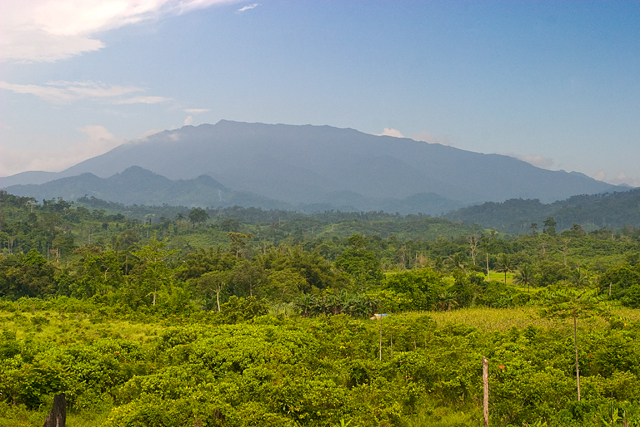
Mount Apo
Image via Wikimedia Commons (author and licence on the file page).

Mount Apo

Mountain · 2,954 m

Mount Apo is a mountain rising to 2,954 metres (9,692 ft) in the Philippines, in the Asia region.

Mount Apo is the highest mountain peak in the Philippines, with an elevation of 2,954 meters (9,692 ft) above sea level. A large solfataric, dormant stratovolcano, it is part of the Apo-Talomo Mountain Range of Mindanao island. Apo is situated on the tripartite border of Davao City, Davao del Sur, and Cotabato; its peak is visible from Davao City 45 kilometers (28 mi) to the northeast, Digos 25 kilometers (16 mi) to the southeast, and Bansalan 20 kilometers (12 mi) to the west. Apo is a protected area and is the centerpiece of Mount Apo Natural Park.

Adapted from Wikipedia: Mount Apo (CC BY-SA 4.0).

Elevation
2,954 m (9,692 ft)
Global rank
#250 of 641 indexed
Region
Asia (#104)
Subregion
Malay Archipelago
Country
Philippines
Coordinates
6.9971°, 125.2699°

Of the 641 named summits indexed in YearMaps, Mount Apo ranks #250 by elevation, below Gora Mus-Khaya (2,959 m) and above Keele Peak (2,952 m).

Ranges:
Maoke Mountains (Oceania), Wuyi Mountains (Asia)
Neighbouring summits:
Mount Halcon (2,585 m), Mount Mantalingajan (2,085 m), Taal Volcano (400 m)
Settlements below:
Davao (42 km), General Santos (99 km), Cotabato (115 km)

View on the live map

More about Mount Apo

Geology

Mount Apo is a flat-topped, 2,954 m (9,692 ft) (above sea level) high stratovolcano with three peaks. It is the highest peak of the Philippines. The southwest peak has the highest elevation and is topped by a 200 m (656 ft) wide crater that contains a small lake.

The volcanic history of Mount Apo is poorly known but eruptions have produced andesitic-to-dacitic lava. A line of solfataras extend from the southeast flank at an elevation of 2,400 m (7,874 ft) to the summit. Mount Apo is not known to have had historical eruptions, and was incorrectly attributed to be the source volcano of the 1641 eruption of Mount Melibengoy, also in Mindanao.

Climate

The climate at the summit of Mount Apo is alpine (Köppen ETH) as its mean temperature does not exceed 10 °C or 50 °F in any month. It falls under the Type IV climate under the modified corona's classification wherein rainfall is uniformly distributed throughout the year. Mean monthly temperature ranges from a low 6.9 °C (44.4 °F) during January to 8.9 °C (48.0 °F) during April. Monthly relative humidity ranges from 78% during March and April and 82% during June and July. Minima reach 2.4 °C (36.3 °F) in January and February.

In late March–April 2016, due to the extreme effects of El Niño caused by climate change, massive patches of forest fires and bushfires appeared on the slopes of the mountain, causing hikers on the mountain to halt their ascent.

Sections adapted from Wikipedia: Mount Apo (CC BY-SA 4.0).

Mount Apo: Key Facts

Key facts about Mount Apo
Topographic prominence2,954 m
Mountain rangeApo–Talomo Range

Facts from Wikidata Q455963 (CC0).

Pulog
Image via Wikimedia Commons (author and licence on the file page).

Pulog

Mountain · 2,934 m

Pulog is a mountain rising to 2,934 metres (9,626 ft) in the Philippines, in the Asia region.

Mount Pulag (Filipino: Bundok Pulag; Ilocano: Bantay Pulag) is Luzon's highest peak at 2,928 metres (9,606 ft) above sea level, third-highest mountain in the Philippines, and the 26th-highest peak of an island on Earth.

It is second-most prominent mountain in the Philippines. Located on the triple border of the provinces of Benguet, Ifugao, and Nueva Vizcaya, the borders meet at the mountain's peak. Mount Pulag is third highest next to Mount Apo and Mount Dulang-dulang.

Mount Pulag is famous for its "sea of clouds" and its exceptional view of the Milky Way Galaxy at dawn, which has attracted many tourists who wish to see the "other-worldly" scenery.

The entire mountain is believed to be the home to the tinmongao spirits and is the sacred resting ground of the souls of the Ibaloi people and other ethnic peoples in the area.

Adapted from Wikipedia: Mount Pulag (CC BY-SA 4.0).

Elevation
2,934 m (9,626 ft)
Global rank
#255 of 641 indexed
Region
Asia (#106)
Subregion
Malay Archipelago
Country
Philippines
Coordinates
16.5964°, 120.9053°

Of the 641 named summits indexed in YearMaps, Pulog ranks #255 by elevation, below Fishers Peak (2,934 m) and above Musala (2,925 m).

Ranges:
Wuyi Mountains (Asia), Dabie Mountains (Asia)
Neighbouring summits:
Mount Pinatubo (1,486 m), Taal Volcano (400 m), Mount Halcon (2,585 m)
Settlements below:
Baguio City (40 km), Dagupan (86 km), Cabanatuan (122 km)

View on the live map

More about Pulog

Geography

Mount Pulag stands at 2,928 metres (9,606 ft) high. The peak of the mountain is located in the Municipality of Kabayan Province of Benguet.

The climate at the summit of Mount Pulag is subpolar oceanic (Köppen Cwc), bordering a subtropical highland (Köppen Cwb) climate, as its summer mean temperatures only slightly exceed 10 degrees Celsius. Rainfall on the mountain averages 4,489 millimetres (176.7 in) yearly with August being the wettest month with an average rainfall of 1,135 millimetres (44.7 in).

Snow has never fallen on its top, as snow is impossible due to lack of elevation and subzero temperatures. However, there are hailstorms that look like snow. Frost is common on the mountain due to the low temperature during those months.

History

The Ibaloi people of Benguet mummify their dead and house them in caverns in the mountain. The Kabayan mummy burial caves, one of the main attraction of the site, are considered Philippine national cultural treasures under Presidential Decree No. 432.

Mt. Pulag was proclaimed a national park through Presidential Proclamation No. 75 signed by President Corazon Aquino on February 20, 1987, covering an area of 11,550 hectares (28,500 acres). It is part of the Cordillera Biogeographic Zone and is a National Integrated Protected Areas Programme (NIPAP) site.

The national park is inhabited by different ethnic groups such as the Ibalois, Kalanguya, Kankana-eys, Karao, and Ifugaos.

Sections adapted from Wikipedia: Mount Pulag (CC BY-SA 4.0).

Pulog: Key Facts

Key facts about Pulog
Topographic prominence2,922 m
Mountain rangeCordillera Central

Facts from Wikidata Q948670 (CC0).

Mount Halcon
Image via Wikimedia Commons (author and licence on the file page).

Mount Halcon

Mountain · 2,585 m

Mount Halcon is a mountain rising to 2,585 metres (8,481 ft) in the Philippines, in the Asia region. From PeakBagger.com, with kind permission..

Mount Halcon (Filipino: Bundok Halcon) and (Spanish: Monte Halcón) is the highest mountain in Mindoro. According to the new data released by Oriental Mindoro peakvisor as of 2022, it has an elevation of 2,616 metres (8,583 ft) above sea level, higher than the previous estimates of 2,586 m (8,484 ft) although no official survey has yet confirmed this. It is the 23rd-highest peak in the Philippines and 37th-highest peak of an island on Earth. Its steep slopes have earned it the reputation of being one of the most difficult and technically most challenging mountains to climb in the Philippines. The first documented ascent was made in 1906 by American botanist Elmer Drew Merrill and a party of forestry and military personnel.

Adapted from Wikipedia: Mount Halcon (CC BY-SA 4.0).

Elevation
2,585 m (8,481 ft)
Global rank
#323 of 641 indexed
Region
Asia (#124)
Subregion
Malay Archipelago
Country
Philippines
Coordinates
13.2601°, 120.9900°

Of the 641 named summits indexed in YearMaps, Mount Halcon ranks #323 by elevation, below Pik Aborigen (2,586 m) and above Mazong Shan (2,584 m).

Ranges:
Wuyi Mountains (Asia), Dângrêk Range (Asia)
Neighbouring summits:
Taal Volcano (400 m), Mount Pinatubo (1,486 m), Pulog (2,934 m)
Settlements below:
Batangas (58 km), San Pablo (97 km), Pasay City (143 km)

View on the live map

More about Mount Halcon

History

The mountain was also the location of a possible World War II Japanese holdout. Isao Miyazawa found evidence that his comrade Captain Fumio Nakahara was living there in 1957. Another search in 1977 was called off due to Miyazawa contracting malaria. In 1980, Miyazawa found Nakahara's hut, and the natives talked to him extensively about the foreigner. However, Nakahara himself has never been spotted.

Sections adapted from Wikipedia: Mount Halcon (CC BY-SA 4.0).

Mount Halcon: Key Facts

Key facts about Mount Halcon
Topographic prominence2,586 m

Facts from Wikidata Q1570683 (CC0).

Mount Mantalingajan
Image via Wikimedia Commons (author and licence on the file page).

Mount Mantalingajan

Mountain · 2,085 m

Mount Mantalingajan is a mountain rising to 2,085 metres (6,841 ft) in the Philippines, in the Asia region.

Mount Mantalingajan (or Mantalingahan or Mantaling) is the highest mountain in the island province of Palawan in the Philippines, with an elevation of 6,844 ft (2,086 m) above sea level, its ranked 68th-highest peak of an island on Earth and 10th-most prominent mountain in the Philippines. Located in the southern part of Palawan Island that forms the highest part of the Beaufort Mountains Ultramafics geological region, a series of ultramafic outcrops of Eocene origin, of which Mount Victoria forms the largest contiguous land area. The peak of the mountain is the highest point on Palawan island.

The mountain forms the center of the Mount Mantalingahan Protected Landscape (MMPL), a national park covering the entire Mantalingahan Mountain Range. The protected area status of MMPL was proclaimed on June 23, 2009, by virtue of Proclamation No. 1815. The protected area covers an area of 120,457 hectares (1,204.57 km2). The entire park is currently listed as a tentative site for UNESCO World Heritage Site inscription.

Adapted from Wikipedia: Mount Mantalingajan (CC BY-SA 4.0).

Elevation
2,085 m (6,841 ft)
Global rank
#400 of 641 indexed
Region
Asia (#147)
Subregion
Malay Archipelago
Country
Philippines
Coordinates
8.8458°, 117.6765°

Of the 641 named summits indexed in YearMaps, Mount Mantalingajan ranks #400 by elevation, below Gora Tardoki-Yani (2,090 m) and above Myinmoletkat Taung (2,072 m).

Ranges:
Dângrêk Range (Asia), Wuyi Mountains (Asia)
Neighbouring summits:
Gunung Kinabalu (4,101 m), Bukit Pagon (1,850 m), Mount Halcon (2,585 m)
Settlements below:
Puerto Princesa (155 km), Sandakan (337 km), Kota Kinabalu (362 km)

View on the live map

More about Mount Mantalingajan

Mount Mantalingajan: Key Facts

Key facts about Mount Mantalingajan
Topographic prominence2,085 m

Facts from Wikidata Q1950593 (CC0).

Mount Pinatubo
Image via Wikimedia Commons (author and licence on the file page).

Mount Pinatubo

Mountain · 1,486 m

Mount Pinatubo is a mountain rising to 1,486 metres (4,875 ft) in the Philippines, in the Asia region.

Mount Pinatubo is an active stratovolcano in the Zambales Mountains in Luzon in the Philippines. Located on the tripoint of Zambales, Tarlac and Pampanga provinces, most people were unaware of its eruptive history before the pre-eruption volcanic activity in early 1991. Dense forests, which supported a population of several thousand indigenous Aetas, heavily eroded and obscured Pinatubo.

Pinatubo is known for its VEI-6 eruption on June 15, 1991, the second-largest terrestrial eruption of the 20th century after the 1912 eruption of Novarupta in Alaska. The eruption coincided with Typhoon Yunya making landfall in the Philippines, which brought a dangerous mix of ash and rain to nearby towns and cities. Early predictions led to the evacuation of tens of thousands of people, saving many lives. The eruption severely damaged surrounding areas with pyroclastic surges, pyroclastic falls, and later, flooding lahars caused by rainwater re-mobilizing volcanic deposits. This destruction affected infrastructure and altered river systems for years. Minor dome-forming eruptions inside the caldera continued from 1992 to 1993.

Adapted from Wikipedia: Mount Pinatubo (CC BY-SA 4.0).

Elevation
1,486 m (4,875 ft)
Global rank
#501 of 641 indexed
Region
Asia (#181)
Subregion
Malay Archipelago
Country
Philippines
Coordinates
15.1418°, 120.3497°

Of the 641 named summits indexed in YearMaps, Mount Pinatubo ranks #501 by elevation, below Feldberg (1,493 m) and above Spruce Knob (1,482 m).

Ranges:
Wuyi Mountains (Asia), Dabie Mountains (Asia)
Neighbouring summits:
Taal Volcano (400 m), Pulog (2,934 m), Mount Halcon (2,585 m)
Settlements below:
Angeles (21 km), Olongapo (35 km), Tarlac (46 km)

View on the live map

More about Mount Pinatubo

Geography

The volcano is about 87 kilometers (54 mi) northwest of Manila, the capital of the Philippines. Near Mount Pinatubo are former military bases that were maintained by the United States. The U.S. Naval Base Subic Bay was 37 kilometers (23 mi) south of Pinatubo, and the extent of Clark Air Base was just 14 kilometers (8.7 mi) east of the volcano's summit. The volcano is near to about 6 million people.

History

Even before the 1991 eruption, Mount Pinatubo had little topographic prominence: it was 1,745 m (5,725 ft) above sea level, only about 600 m (2,000 ft) above nearby plains, and only about 200 m (660 ft) higher than surrounding peaks, which largely obscured it from view. It is part of a chain of volcanoes which lie along the western side of the island of Luzon called the Zambales Mountains.

Pinatubo belongs to the Cabusilan sub-range of the Zambales Mountains, which consists of Mount Cuadrado, Mount Negron, Mount Mataba and Mount Pinatubo. They are subduction volcanoes, formed by the Eurasian plate sliding under the Philippine Mobile Belt along the Manila Trench to the west.

Cultural history

The word pinatubo could mean "fertile place where one can make crops grow", or could mean "made to grow", in Sambal and Tagalog, which may suggest a knowledge of its previous eruption in about 1500 AD. There is a local oral tradition suggestive of a folk memory of earlier large eruptions. An ancient legend tells of Bacobaco, a terrible spirit of the sea, who could metamorphose into a huge turtle and throw fire from his mouth. In the legend, when being chased by the spirit hunters, Bacobaco flees to the mountain and digs a great hole in its summit showering the surrounding land with rock, mud, dust and fire for three days; howling so loudly that the earth shakes.

Sections adapted from Wikipedia: Mount Pinatubo (CC BY-SA 4.0).

Mount Pinatubo: Key Facts

Key facts about Mount Pinatubo
Mountain rangeZambales Mountains

Facts from Wikidata Q1451 (CC0).

Taal Volcano
Image via Wikimedia Commons (author and licence on the file page).

Taal Volcano

Mountain · 400 m

Taal Volcano is a mountain rising to 400 metres (1,312 ft) in the Philippines, in the Asia region.

Taal Volcano (IPA: [taʔal]; Tagalog: Bulkang Taal), also known as Taal Caldera, is a large caldera filled by Taal Lake in the Philippines. Located in the province of Batangas about 50 kilometers (31 mi) south of Manila, the volcano is the second most active volcano in the country, with 39 confirmed historical eruptions, concentrated on Volcano Island, near the middle of Taal Lake. The caldera was formed by prehistoric eruptions between less than 670,000 and less than 6,000 years ago. The cones Batulao, Macolod, and Sungay are remnants of the early pre-caldera Taal system, with Batulao being the earliest known cone.

Taal Volcano has had several violent eruptions in the past, causing deaths on the island and the populated areas surrounding the lake, with an overall recorded death toll of about 6,000. Because of its proximity to populated areas and its eruptive history, the volcano was designated a Decade Volcano, worthy of close study to prevent future natural disasters. The site was declared National Geological Monument in 1998 and a national park in 2018.

Adapted from Wikipedia: Taal Volcano (CC BY-SA 4.0).

Elevation
400 m (1,312 ft)
Global rank
#618 of 641 indexed
Region
Asia (#194)
Subregion
Malay Archipelago
Country
Philippines
Coordinates
14.0019°, 120.9928°

Of the 641 named summits indexed in YearMaps, Taal Volcano ranks #618 by elevation, below Mount Obama (402 m) and above Murray Hill (356 m).

Ranges:
Wuyi Mountains (Asia), Dabie Mountains (Asia)
Neighbouring summits:
Mount Halcon (2,585 m), Mount Pinatubo (1,486 m), Pulog (2,934 m)
Settlements below:
Batangas (25 km), San Pablo (36 km), Pasay City (61 km)

View on the live map

More about Taal Volcano

Geography

Taal Volcano is part of a chain of volcanoes lining the western edge of the island of Luzon. They were formed by the subduction of the Eurasian Plate underneath the Philippine Mobile Belt. Taal Lake lies within a 25–30 km (16–19 mi) caldera formed by explosive eruptions between less than 670 ka (Sampaga Formation) and less than 3 ka to 1000CE (Buco Formation). Each of these eruptions created extensive ignimbrite deposits reaching as far away as present-day Manila.

Taal Volcano is primarily located in the province of Batangas however, the northern caldera rim and the northern segment of its massive ignimbrite shield is located on Tagaytay which is in Cavite.

Eruptive history

The prehistoric eruptions of Taal were either large caldera forming events or minor eruptions similar to what is observed today. The major eruptions helped create the present Taal Lake, with a large eruption termed "The Pasong Fluidal Juvenile Bomb-Rich Ignimbrite Formation" ejecting 144 km3 (35 cu mi) of material, shaping the immediate landscape with pyroclastic flows and thick ash deposits across southern Luzon. Prehistoric eruptions left significant deposits of pumice and pyroclastic material across southern Luzon, with thicknesses up to 45-meter (148-foot) in some areas, impacting vast regions.

Sections adapted from Wikipedia: Taal Volcano (CC BY-SA 4.0).

More on Philippines

Quick Answers

What is the highest mountain in Philippines?
Mount Apo, at 2,954 m. Pulog is second at 2,934 m. Rankings cover the mountains indexed in YearMaps.
How many mountains are there in Philippines?
YearMaps lists 7 mountains for Philippines. This is the number mapped in the atlas, not an official national count.