
UNESCO World Heritage Sites in Australia
Australia has 18 sites on the UNESCO World Heritage List (4 cultural, 10 natural and 4 mixed), the first inscribed in 1981 (Great Barrier Reef). The map below plots every one of them alongside the rest of the List, and each site is written up in full further down the page.
- World Heritage Sites
- 18
- Cultural
- 4
- Natural and Mixed
- 14
- First Inscribed
- 1981
Map of World Heritage Sites in Australia
CulturalNaturalMixedIn DangerLarge dots are in Australia. Click a dot to read about the site.

Great Barrier Reef
Australia · 16.4000° S, 145.8000° E · 348,700 km² · 54 km from Cairns
The Great Barrier Reef is the world's largest coral reef system, composed of over 2,900 individual reefs and 900 islands stretching for over 2,300 kilometres (1,400 mi) over an area of approximately 344,400 square kilometres (133,000 mi2). The reef is located in the Coral Sea, off the coast of Queensland, Australia. It is separated from the coast by a channel 160 kilometres (100 mi) wide in places and over 61 metres (200 ft) deep. The Great Barrier Reef can be seen from outer space and is the world's biggest single structure made by living organisms. This reef structure is composed of and built by billions of tiny organisms, known as coral polyps. It supports a wide diversity of life and was selected as a World Heritage Site in 1981. CNN labelled it one of the Seven Natural Wonders of the World in 1997. Australian World Heritage places included it in its list in 2007. The Queensland National Trust named it a state icon of Queensland in 2006.
A large part of the reef is protected by the Great Barrier Reef Marine Park, which helps to limit the impact of human use, such as fishing and tourism.
Adapted from Wikipedia: Great Barrier Reef (CC BY-SA 4.0).
Why Great Barrier Reef Is Listed
- (vii)
- Superlative natural phenomena or exceptional natural beauty.
- (viii)
- An outstanding example of major stages of the Earth's history.
- (ix)
- An outstanding example of ongoing ecological and biological processes.
- (x)
- The most important natural habitats for conserving biodiversity.
More about Great Barrier Reef
UNESCO's Description
The Great Barrier Reef is a site of remarkable variety and beauty on the north-east coast of Australia. It contains the world’s largest collection of coral reefs, with 400 types of coral, 1,500 species of fish and 4,000 types of mollusc. It also holds great scientific interest as the habitat of species such as the dugong (‘sea cow’) and the large green turtle, which are threatened with extinction.
From the UNESCO World Heritage Centre (CC BY-SA IGO 3.0).
Geology and geography
The Great Barrier Reef is a distinct feature of the East Australian Cordillera division. It reaches from Torres Strait (between Bramble Cay, its northernmost island, and the south coast of Papua New Guinea) in the north to the unnamed passage between Lady Elliot Island (its southernmost island) and Fraser Island in the south. Lady Elliot Island is located 1,915 km (1,190 mi) southeast of Bramble Cay as the crow flies. It includes the smaller Murray Islands.
The plate tectonic theory indicates Australia has moved northwards at a rate of 7 cm (2.8 in) per year, starting during the Cenozoic. Eastern Australia experienced a period of tectonic uplift, which moved the drainage divide in Queensland 400 km (250 mi) inland.
Ecology
The Great Barrier Reef supports an extraordinary diversity of life, including many vulnerable or endangered species, some of which may be endemic to the reef system.
Thirty species of cetaceans have been recorded in the Great Barrier Reef, including the dwarf minke whale, Indo-Pacific humpback dolphin, and the humpback whale. Large populations of dugongs live there. More than 1,500 fish species live on the reef, including the clownfish, red bass, red-throat emperor, and several species of snapper and coral trout. Forty-nine species mass spawn, while eighty-four other species spawn elsewhere in their range. Seventeen species of sea snake live on the Great Barrier Reef in warm waters up to 50 metres (160 ft) deep and are more common in the southern than in the northern section.
Sections adapted from Wikipedia: Great Barrier Reef (CC BY-SA 4.0).

Kakadu National Park
Australia · 13.0055° S, 132.5195° E · 19,810 km²
This unique archaeological and ethnological reserve, located in the Northern Territory, has been inhabited continuously for more than 40,000 years. The cave paintings, rock carvings and archaeological sites record the skills and way of life of the region’s inhabitants, from the hunter-gatherers of prehistoric times to the Aboriginal people still living there. It is a unique example of a complex of ecosystems, including tidal flats, floodplains, lowlands and plateaux, and provides a habitat for a wide range of rare or endemic species of plants and animals.
Description from the UNESCO World Heritage Centre (CC BY-SA IGO 3.0).
Why Kakadu National Park Is Listed
- (i)
- A masterpiece of human creative genius.
- (vi)
- A direct association with events, ideas or beliefs of universal significance.
- (vii)
- Superlative natural phenomena or exceptional natural beauty.
- (ix)
- An outstanding example of ongoing ecological and biological processes.
- (x)
- The most important natural habitats for conserving biodiversity.

Willandra Lakes Region
Australia · 33.6181° S, 143.1014° E · 2,400 km² · 108 km from Mildura
The Willandra Lakes Region is a World Heritage Site in the Far West region of New South Wales, Australia. The Willandra Lakes Region is the traditional meeting place of the Muthi Muthi, Ngiyampaa and Paakantyi Aboriginal peoples. The 2,400-square-kilometre (930 sq mi) area was inscribed on the World Heritage List at the 5th Session of the World Heritage Committee in 1981.
The Region contains important natural and cultural features including exceptional examples of past human civilization including the world's oldest evidence of cremation. A small section of the region is protected by the Mungo National Park.
The World Heritage status of the region was created and negotiated in 1981. The site was gazetted on the Australian National Heritage List on 21 May 2007 under the Environment and Heritage Legislation Amendment Act (No. 1), 2003 (Cth). The region is also listed on the New South Wales State Heritage Register.
Adapted from Wikipedia: Willandra Lakes Region (CC BY-SA 4.0).
Why Willandra Lakes Region Is Listed
- (iii)
- A unique testimony to a cultural tradition or civilisation.
- (viii)
- An outstanding example of major stages of the Earth's history.
More about Willandra Lakes Region
UNESCO's Description
The fossil remains of a series of lakes and sand formations that date from the Pleistocene can be found in this region, together with archaeological evidence of human occupation dating from 45–60,000 years ago. It is a unique landmark in the study of human evolution on the Australian continent. Several well-preserved fossils of giant marsupials have also been found here.
From the UNESCO World Heritage Centre (CC BY-SA IGO 3.0).
History
Willandra Lakes has formed over the last 2 million years. The ancient shorelines are stratified into three major layers of sediments that were deposited at different stages in the lakes' history.
The earliest sediments are more than 50,000 years old and are orange-red in colour. Above are clay, clean quartz sand and soil that were deposited along the lakes' edge when the lakes were full of deep relatively fresh water between 50,000 and 19,000 years ago. The top layer is composed largely of wind blown clay particles heaped up on the lunettes during periods of fluctuating water levels, before the lakes finally dried up.
Aboriginal people lived on the shores of the Willandra Lakes from 40,000 to 35,000 years ago. It is one of the oldest known human occupation sites in Australia.
Description
Willandra Lakes is located in south-western New South Wales. The lakes system, a remnant of the Lachlan River drainage pattern, is approximately 150 km long by 40 km wide and runs generally in a north–south direction from Lake Mulurulu in the north to Lake Prungle in the south. The approximate area is 600,000 hectares. Parallel to the eastern shores, white sand and clay dunes rise 40 metres above the plain, while deep gullies have been cut through the lake shore deposits. The landscape surrounding the system is one of low, parallel ridges of fine red sand.
Lake Mungo, the best known of the lakes in the area, is in the centre of the Willandra Lakes system about 100 km north-east of Mildura.
Sections adapted from Wikipedia: Willandra Lakes Region (CC BY-SA 4.0).
Key Facts
| Established | 1981 |
|---|---|
| Area | 2,400 km² |
Facts from Wikidata Q747875 (CC0).
Visiting Willandra Lakes Region
The Willandra Lakes Region is a World Heritage Site (WHS) in the southwestern ends of Outback New South Wales.
The main thing to see in the region is Mungo National Park, however, the WHS is much more than the park.
The Willandra Lakes Region is the traditional meeting place of the Muthi Muthi, Ngiyampaa and Barkinji Aboriginal tribes. Willandra's archaeological record demonstrates continuous human occupation of the area for at least 40,000 years. It is one of the oldest known human occupation sites in Australia. There is abundant evidence of Aboriginal occupation over the last 10,000 years.
Travel notes adapted from Wikivoyage: Willandra Lakes Region (CC BY-SA 4.0).

Lord Howe Island Group
Australia · 31.5562° S, 159.0797° E · 1,463 km²
A remarkable example of isolated oceanic islands, born of volcanic activity more than 2,000 m under the sea, these islands boast a spectacular topography and are home to numerous endemic species, especially birds.
Description from the UNESCO World Heritage Centre (CC BY-SA IGO 3.0).
Why Lord Howe Island Group Is Listed
- (vii)
- Superlative natural phenomena or exceptional natural beauty.
- (x)
- The most important natural habitats for conserving biodiversity.

Tasmanian Wilderness
Australia · 42.5957° S, 146.1729° E · 15,842 km² · 96 km from Hobart
The Tasmanian Wilderness World Heritage Area, abbreviated to TWWHA, is a World Heritage Site in Tasmania, Australia. It is one of the largest conservation areas in Australia, covering 15,800 km2 (6,100 mi2), or almost 25 per cent of Tasmania. It is also one of the last expanses of temperate wilderness in the world, and includes the South West Wilderness.
The main industry of the TWWHA is tourism, yet the region has a lack of development partially due to the juxtaposition of development with the idea of pristine nature. There is no permanent habitation in the area save for small parts on the periphery. The region is known for activities such as bushwalking, whitewater rafting, and climbing.
The Tasmanian Wilderness qualifies for 7 out of the 10 classification criteria evaluated for World Heritage. Along with Mount Tai in China, it is the highest measurement attained for World Heritage Site status on Earth.
Adapted from Wikipedia: Tasmanian Wilderness World Heritage Area (CC BY-SA 4.0).
Why Tasmanian Wilderness Is Listed
- (iii)
- A unique testimony to a cultural tradition or civilisation.
- (iv)
- An outstanding example of a type of building or landscape.
- (vi)
- A direct association with events, ideas or beliefs of universal significance.
- (vii)
- Superlative natural phenomena or exceptional natural beauty.
- (viii)
- An outstanding example of major stages of the Earth's history.
- (ix)
- An outstanding example of ongoing ecological and biological processes.
- (x)
- The most important natural habitats for conserving biodiversity.
More about Tasmanian Wilderness
UNESCO's Description
In a region that has been subjected to severe glaciation, these parks and reserves, with their steep gorges, covering an area of over 1 million ha, constitute one of the last expanses of temperate rainforest in the world. Remains found in limestone caves attest to the human occupation of the area for more than 20,000 years.
From the UNESCO World Heritage Centre (CC BY-SA IGO 3.0).
Geography
The Tasmanian Wilderness is an extensive, wet, temperate, wilderness area covering much of southern and western Tasmania. It is approximately 200 km (120 mi) north to south and averages 70 km (43 mi) east to west, or 1.38 million ha (3.4 million acres) before expansions in 2013. The area of the region became 15,800 kilometres2, or almost 25% of Tasmania after extensions in 1989 and 2013. Although the highest point is only 1,600 metres (5,000 feet) above sea level and there is no year-round snow cover, much of the area is very rugged and contains the only extensive, recently glaciated areas in Australia. The last glaciation ended 10,000 to 12,000 years ago. It constitutes one of the last expanses of temperate wilderness in the world, and includes the South West Wilderness.
History
The Tasmanian Wilderness, a network of parks and reserves with steep gorges, underwent severe glaciation. Human remains dating back more than 20,000 years have been found in limestone caves in the area. The area was used for millennia by Aboriginal Tasmanians, who have left their signature on the area in the form of an ecology strongly influenced by their burning practices, as well as physical remains including middens and artwork. The Aboriginal presence in the area dates back to the Pleistocene, 35,000 years ago. Middens from the Holocene have been found in the area. The Aboriginal people were removed from the region during the 1830s by George Augustus Robinson, acting under the policies of the local colonial British government.
Background
Tasmania is one of the states of Australia. It is an island in the Southern Ocean, immediately south of mainland Australia, the Bass Strait separating them. It has a temperate maritime climate, substantially different from most of mainland Australia. Australia has 21 World Heritage Sites, the first of which was listed in 1981. The best known are Kakadu, Uluru (formerly known as Ayers Rock) and the Great Barrier Reef. The Tasmanian Wilderness is probably the best known of the rest.
Tasmania is approximately 296 km (184 mi) north to south and 315 km (196 mi) east to west, and about 300 km (190 mi) south of mainland Australia. Around 30 per cent of the state's land is reserved under some category of conservation land tenure.
Development and tourism
The Tasmanian Wilderness contains no permanent human habitation, apart from a small amount of accommodation near the periphery. Few roads penetrate the area. There is also a trout fishery (introduced northern hemisphere species) in the Central Plateau lakes. Unlike most of the rest of the Tasmanian Wilderness, the Central Plateau section has a long history of use by local people. As well as fishing, some hunting, horse riding, four-wheel-driving and associated hut use continues.
Sections adapted from Wikipedia: Tasmanian Wilderness World Heritage Area (CC BY-SA 4.0).
Key Facts
| Established | 1982 |
|---|---|
| Area | 15,842 km² |
Facts from Wikidata Q138170 (CC0).
Visiting Tasmanian Wilderness
The Tasmanian Wilderness is a UNESCO World Heritage Site covering nearly a quarter of the state and one of the last expanses of temperate wilderness in the world. Generally, most UNESCO World Heritage Sites only fulfill either one to three of the criteria out of the ten to be listed as a UNESCO World Heritage Site. However, the Tasmanian Wilderness World Heritage Area fulfill seven of the ten criterion, with the only other place to fulfill that criteria being Mount Taishan in China.
The area consists of the following parks.
1 Central Plateau Conservation Area
2 Cradle Mountain-Lake St Clair National Park
3 Devils Gullet State Reserve
4 Franklin-Gordon Wild Rivers National Park
5 Hartz Mountains National Park
6 Mole Creek Karst National Park
7 Mount Field National Park
8 South-East Mutton Bird Islet
9 Southwest National Park
10 Walls of Jerusalem National Park
Travel notes adapted from Wikivoyage: Tasmanian Wilderness World Heritage Area (CC BY-SA 4.0).

Gondwana Rainforests of Australia
Australia · 29.6000° S, 149.6000° E · 3,700 km²
The Gondwana Rainforests of Australia, formerly known as the Central Eastern Rainforest Reserves, are a World Heritage Site, encompassing 41 rainforest reserves with a total area of approximately 370,000 ha (910,000 acres) in north-east New South Wales and south-east Queensland. The site was added to the World Heritage List in 1986 and was expanded in 1994. The Gondwana Rainforests are also listed on the Australian National Heritage List and the New South Wales Heritage Register.
The Gondwana Rainforests are home to a number of plant and animal species whose lineages trace back to before the separation of the landmass Gondwana, some of which are only found in the region. These include early examples of ferns, conifers, and flowering plants. The reserves that make up the site are among the last remaining examples of the rainforests that covered most of Australia at the time of its separation from Gondwana. The Gondwana Rainforests are the world's most significant subtropical rainforests and include almost all of the world's Antarctic beech cool temperate rainforests.
Adapted from Wikipedia: Gondwana Rainforests (CC BY-SA 4.0).
Why Gondwana Rainforests of Australia Is Listed
- (viii)
- An outstanding example of major stages of the Earth's history.
- (ix)
- An outstanding example of ongoing ecological and biological processes.
- (x)
- The most important natural habitats for conserving biodiversity.
More about Gondwana Rainforests of Australia
UNESCO's Description
This site, comprising several protected areas, is situated predominantly along the Great Escarpment on Australia’s east coast. The outstanding geological features displayed around shield volcanic craters and the high number of rare and threatened rainforest species are of international significance for science and conservation.
From the UNESCO World Heritage Centre (CC BY-SA IGO 3.0).
History
Australia separated from the landmass Gondwana about 40 million years ago, at which point most of the continent was covered in rainforests. These rainforests receded as the continent travelled north, and by 1788, just 1% of Australia was covered by rainforests. These rainforests were used by Aboriginal Australians for varied purposes, including as a site for ceremonial activities, as a source of food and shelter, and as a refuge from European settlement. Australia's remaining rainforests were heavily affected by logging following European colonisation, which led to the destruction of a further 75% of the rainforests that had been present in 1788.
Sections adapted from Wikipedia: Gondwana Rainforests (CC BY-SA 4.0).
Key Facts
| Established | 1986 |
|---|---|
| Area | 3,687 km² |
Facts from Wikidata Q643063 (CC0).
Visiting Gondwana Rainforests of Australia
The Gondwana Rainforests of Australia (CERRA) World Heritage Site is made up of a number of non-contiguous areas of national park and reserve land in northeastern New South Wales and South East Queensland. These rainforests are so called because the species found here existed hundreds of millions of years ago when Australia was part of the supercontinent Gondwana. They can be geographically grouped into 8 distinct regions:
Travel notes adapted from Wikivoyage: Gondwana Rainforests of Australia (CC BY-SA 4.0).

Uluṟu-Kata Tjuṯa National Park
Australia · 25.3221° S, 130.9857° E · 1,326 km²
Uluṟu-Kata Tjuṯa National Park is a protected area in the Northern Territory of Australia. The park is home to both Uluru and Kata Tjuta. It is located 1,943 kilometres (1,207 mi) south of Darwin by road and 440 kilometres (270 mi) south-west of Alice Springs along the Stuart and Lasseter Highways. The Outback Highway linking Western Australia and Queensland, and being developed as Australia's third east-west transcontinental route, shares the main road through the park.
The park covers 1,326 square kilometres (512 sq mi) and includes the features it is named after: Uluru and, 40 kilometres (25 mi) to its west, Kata Tjuta. The location is listed as a UNESCO World Heritage Site for natural and cultural landscape in 1987.
Adapted from Wikipedia: Uluṟu-Kata Tjuṯa National Park (CC BY-SA 4.0).
Why Uluṟu-Kata Tjuṯa National Park Is Listed
- (v)
- An outstanding example of traditional human settlement or land use.
- (vi)
- A direct association with events, ideas or beliefs of universal significance.
- (vii)
- Superlative natural phenomena or exceptional natural beauty.
- (viii)
- An outstanding example of major stages of the Earth's history.
More about Uluṟu-Kata Tjuṯa National Park
UNESCO's Description
This park, formerly called Uluru (Ayers Rock – Mount Olga) National Park, features spectacular geological formations that dominate the vast red sandy plain of central Australia. Uluru, an immense monolith, and Kata Tjuta, the rock domes located west of Uluru, form part of the traditional belief system of one of the oldest human societies in the world. The traditional owners of Uluru-Kata Tjuta are the Anangu Aboriginal people.
From the UNESCO World Heritage Centre (CC BY-SA IGO 3.0).
Geography
These domed rock formations are composed of conglomerate, a sedimentary rock consisting of cobbles and boulders of varying rock types including granite and basalt, cemented by a matrix of sandstone. The crevasses are due to erosion, primarily by water. Although it is a dry region, the large area of these domes collects a lot of rainwater, which runs off in steep waterfalls during rain.
500 million years ago, the entire area was covered by an inland sea and over many centuries, sand and mud fell to the bottom of the sea, creating rock and sandstone. Kata Tjuta's domes are the eroded remains of sedimentary rock from the seabed, while Uluru is a relict of the coarse grained, mineral-rich sandstone called arkose.
History
Uluru and Kata Tjuta were formed about 350 million years ago during the Alice Springs Orogeny.
The Anangu have connected to the area for thousands of years and some records suggested that they may have lived there for more than 10,000 years.
Europeans came to the western desert area of Australia in the 1870s. Uluru and Kata Tjuta were first mapped by Europeans during the expeditionary period made possible by the construction of the Overland Telegraph Line in 1872.
In separate expeditions, William Ernest Powell Giles and William Christie Gosse were the first European explorers to this area.
Overview
Uluru / Ayers Rock is considered one of Australia's most recognisable landmarks, and has become a focal point for Australia and the world's acknowledgement of Australian indigenous culture. The sandstone monolith stands 348 metres (1,142 ft) high with most of its bulk below the ground. To Anangu, the local indigenous people, Uluru / Ayers Rock is a place name and this "Rock" has a number of different landmarks where many ancestral beings have interacted with the landscape and/or each other, some even believed to still reside here. Kata Tjuta / Mount Olga, meaning 'many heads' in his aboriginal name, is a sacred place relating to knowledge that is considered very powerful and dangerous, only suitable for initiated men.
Sections adapted from Wikipedia: Uluṟu-Kata Tjuṯa National Park (CC BY-SA 4.0).
Key Facts
| Established | 23 January 1958 |
|---|---|
| Area | 1,334 km² |
Facts from Wikidata Q251999 (CC0).
Visiting Uluṟu-Kata Tjuṯa National Park
Uluṟu-Kata Tjuṯa National Park is a park in the Northern Territory of Australia, part of the so-called Red Centre of the continent. The national park is a UNESCO World Heritage area and is best known for Uluṟu (also known as Ayers Rock), a single massive rock formation, and also for Kata Tjuṯa (also known as "The Olgas"), a range of rock domes.
Yulara is the only service village nearby, built to offer supplies and accommodation for visitors to the park.
Travel notes adapted from Wikivoyage: Uluṟu-Kata Tjuṯa National Park (CC BY-SA 4.0).

Wet Tropics of Queensland
Australia · 17.2000° S, 145.8000° E · 8,935 km² · 35 km from Cairns
The Wet Tropics of Queensland World Heritage Site is an area of approximately 8,940 km2 (3,450 sq mi) of very wet forests on parts of the coast and adjacent ranges of tropical Queensland, Australia. The area meets all four of the natural heritage selection criteria for a World Heritage site. World Heritage status was declared in 1988, and on 21 May 2007 the Wet Tropics was added to the Australian National Heritage List.
The tropical forests have the highest concentration of primitive flowering plant families in the world. Only Madagascar and New Caledonia, due to their historical isolation, have humid, tropical regions with a comparable level of endemism.
The Wet Tropics rainforests are a biodiversity hotspot and are recognised internationally for their ancient ancestry and many unique plants and animals. The area covers 0.1% of the Australian landmass but contains 50 per cent of all the nation's species. Many plant and animal species in the Wet Tropics are found nowhere else in the world. The Wet Tropics has the oldest continuously surviving tropical rainforests on earth.
Adapted from Wikipedia: Wet Tropics of Queensland (CC BY-SA 4.0).
Why Wet Tropics of Queensland Is Listed
- (vii)
- Superlative natural phenomena or exceptional natural beauty.
- (viii)
- An outstanding example of major stages of the Earth's history.
- (ix)
- An outstanding example of ongoing ecological and biological processes.
- (x)
- The most important natural habitats for conserving biodiversity.
More about Wet Tropics of Queensland
UNESCO's Description
This area, which stretches along the north-east coast of Australia for some 450 km, is made up largely of tropical rainforests. This biotope offers a particularly extensive and varied array of plants, as well as marsupials and singing birds, along with other rare and endangered animals and plant species.
From the UNESCO World Heritage Centre (CC BY-SA IGO 3.0).
Geography
The Wet Tropics of Queensland stretches in part from Townsville to Cooktown, running in close parallel to the Great Barrier Reef (another World Heritage Site).
The terrain is rugged. The Great Dividing Range and a number of small coastal ranges, highlands, tablelands, foothills and an escarpment dominate the landscape.
The heritage site contains the northern section of the Queensland tropical rain forests including the Daintree Rainforest. Sixteen different structural types of rainforest have been identified.
The World Heritage area includes Australia's highest waterfall, Wallaman Falls. In total it spans 13 major river systems including the Annan, Bloomfield, Daintree, Barron, Mulgrave, Russell, Johnstone, Tully, Herbert, Burdekin, Mitchell, Normanby and Palmer River.
Climate
Rainfall in the area varies considerably, with elevation and orientation of the coastline being the major influences. Rainfall averages from 1,200 millimetres (mm) to over 8,000 mm annually. The highest mountains along the escarpment between Cairns and Tully receive the highest rainfall, mainly owing to orographic factors. Mount Bellenden Ker is the wettest recording station in the area with other high peaks and eastern slopes favouring high rainfall. Most of the rainfall occurs from November to April. Tropical cyclones may impact the area.
Sections adapted from Wikipedia: Wet Tropics of Queensland (CC BY-SA 4.0).
Key Facts
| Established | 1988 |
|---|---|
| Area | 8,938 km² |
Facts from Wikidata Q1135808 (CC0).
Shark Bay
Australia · 25.9290° S, 113.6047° E · 22,009 km²
At the most westerly point of the Australian continent, Shark Bay, with its islands and the land surrounding it, has three exceptional natural features: its vast sea-grass beds, which are the largest (4,800 km2) and richest in the world; its dugong (‘sea cow’) population; and its stromatolites (colonies of algae which form hard, dome-shaped deposits and are among the oldest forms of life on earth). Shark Bay is also home to five species of endangered mammals.
Description from the UNESCO World Heritage Centre (CC BY-SA IGO 3.0).
Why Shark Bay Is Listed
- (vii)
- Superlative natural phenomena or exceptional natural beauty.
- (viii)
- An outstanding example of major stages of the Earth's history.
- (ix)
- An outstanding example of ongoing ecological and biological processes.
- (x)
- The most important natural habitats for conserving biodiversity.

K'gari
Australia · 25.2400° S, 153.1500° E · 1,819 km² · 32 km from Hervey Bay
K'gari (Batjala for 'Paradise', English: GAH-ree), also known by its former name Fraser Island, is a World Heritage-listed sand island along the south-eastern coast in the Wide Bay–Burnett region of Queensland, Australia. The island lies approximately 250 km (160 mi) north of the state capital, Brisbane, and is within the Fraser Coast Region local council area. The world heritage listing includes the island, its surrounding waters and parts of the nearby mainland which make up the Great Sandy National Park. In the 2021 census, the island had a population of 152. Up to 500,000 people visit the island each year.
The island is part of the traditional lands of the Butchulla people, under the traditional name of "K'gari". European settlers who arrived in 1847 named the island "Fraser Island" after Captain James Fraser, master of Stirling Castle, who was shipwrecked and died on the island in early August 1836. On 7 June 2023, the island was officially renamed K'gari by the state government.
Adapted from Wikipedia: K'gari (CC BY-SA 4.0).
Why K'gari Is Listed
- (vii)
- Superlative natural phenomena or exceptional natural beauty.
- (viii)
- An outstanding example of major stages of the Earth's history.
- (ix)
- An outstanding example of ongoing ecological and biological processes.
More about K'gari
UNESCO's Description
K’gari lies just off the east coast of Australia. At 122 km long, it is the largest sand island in the world. Majestic remnants of tall rainforest growing on sand and half the world’s perched freshwater dune lakes are found inland from the beach. The combination of shifting sand-dunes, tropical rainforests and lakes makes it an exceptional site.
From the UNESCO World Heritage Centre (CC BY-SA IGO 3.0).
Geography and ecology
The island is about 123 km (76 mi) long and 22 km (14 mi) wide. It was inscribed as a World Heritage Site in 1992. The island is the largest sand island in the world at 1,840 km2 (710 sq mi). It is also Queensland's largest island, Australia's sixth largest island and the largest island on the east coast of Australia.
K'gari has rainforests, eucalyptus woodland, mangrove forests, wallum and peat swamps, sand dunes and coastal heaths. It is made up of sand that has been accumulating for approximately 750,000 years on volcanic bedrock that provides a natural catchment for the sediment carried on a strong offshore current northwards along the coast.
History
The lands that include the current day island have been inhabited from between 5,000 and 50,000 years ago by the Butchulla people. Originally attached to the mainland, K'Gari became an island 10,000–20,000 years ago due to rising seas.
The K'gari creation story, as told by Butchulla elder Olga Miller, is that Yendingie (also Yindingie) came down from the sky and set to work to make the sea and then the land until, when he arrived at the area now known as Hervey Bay, he was joined by a helper — a beautiful white spirit called Princess K'gari. K'gari fell in love with the beautiful land they had created and begged to be allowed to stay rather than returning to heaven.
Tourism
K'gari is one of Queensland's most popular islands for tourists, who can reach the island by ferry from Hervey Bay or Rainbow Beach, which takes approximately 50 minutes. Estimates of the number of visitors to the island each year range from 350,000 to 500,000. The chance of seeing a dingo in its natural setting is one of the main reasons people visit the island. The use of boardwalks and marked tracks by visitors is encouraged to reduce erosion.
It was reported in 2009 that tourists had created environmental problems in K'gari's lakes and on coastal dunes, as the foredunes were being used as a toilet by an estimated 90,000 bush campers each year. Many of the perched lakes have no outflow or inflow which exacerbates the problem.
Sections adapted from Wikipedia: K'gari (CC BY-SA 4.0).
Visiting K'gari
K'gari (pronounced "Gurri", formerly Fraser Island) is a large sand island 122 km (76 miles) long (the largest sand island in the world) situated off the southern coast of the Australian state of Queensland, some 300 km (200 miles) north of the state capital Brisbane. A popular destination for travellers, K'gari was inscribed as a World Heritage Site in 1992.
Most of the island is taken up by the Great Sandy National Park, which has some additional sections on the mainland.
Travel notes adapted from Wikivoyage: K'gari (CC BY-SA 4.0).

Australian Fossil Mammal Sites (Riversleigh / Naracoorte)
Australia · 19.0833° S, 138.7167° E · 103 km²
Australian Fossil Mammal Sites (Riversleigh / Naracoorte) is a combined listing in the UNESCO World Heritage Sites for two places in Australia known for their extensive fossil remains.
The UNESCO listing is for two separate areas where fossils from the Cenozoic Era have been found:
Australian Fossil Mammal Sites (Riversleigh) in Queensland
Australian Fossil Mammal Sites (Naracoorte) in South Australia
Riversleigh and Naracoorte are considered to be among the world's 10 greatest fossil sites and both locations are notable for the extreme diversity and quality of preservation of their fossils, which illustrate the evolution of mammals in Australia over the last 20 million years and demonstrate how marsupials adapted to climate changes over the last 170,000 years.
The Australian Fossil Mammal Sites (Riversleigh/Naracoorte) was inscribed on the UNESCO World Heritage List in 1994 for its outstanding universal value, and was added to the Australian National Heritage List on 21 May 2007, as a collective area of outstanding value for Australia.
Adapted from Wikipedia: Australian Fossil Mammal Sites (Riversleigh / Naracoorte) (CC BY-SA 4.0).
Why Australian Fossil Mammal Sites (Riversleigh / Naracoorte) Is Listed
- (viii)
- An outstanding example of major stages of the Earth's history.
- (ix)
- An outstanding example of ongoing ecological and biological processes.
More about Australian Fossil Mammal Sites (Riversleigh / Naracoorte)
UNESCO's Description
Riversleigh and Naracoorte, situated in the north and south respectively of eastern Australia, are among the world’s 10 greatest fossil sites. They are a superb illustration of the key stages of evolution of Australia’s unique fauna.
From the UNESCO World Heritage Centre (CC BY-SA IGO 3.0).
Key Facts
| Established | 1994 |
|---|---|
| Area | 103 km² |
Facts from Wikidata Q15933552 (CC0).

Greater Blue Mountains Area
Australia · 33.7000° S, 150.0000° E · 10,326 km² · 30 km from Katoomba
The Greater Blue Mountains Area is a World Heritage Site located in the Blue Mountains of New South Wales, Australia. The 1,032,649-hectare (2,551,730-acre) area was placed on the World Heritage List at the 24th Session of the World Heritage Committee, held in Cairns in 2000.
Adapted from Wikipedia: Greater Blue Mountains Area (CC BY-SA 4.0).
Why Greater Blue Mountains Area Is Listed
- (ix)
- An outstanding example of ongoing ecological and biological processes.
- (x)
- The most important natural habitats for conserving biodiversity.
More about Greater Blue Mountains Area
UNESCO's Description
The Greater Blue Mountains Area consists of 1.03 million ha of sandstone plateaux, escarpments and gorges dominated by temperate eucalypt forest. The site, comprised of eight protected areas, is noted for its representation of the evolutionary adaptation and diversification of the eucalypts in post-Gondwana isolation on the Australian continent. Ninety-one eucalypt taxa occur within the Greater Blue Mountains Area which is also outstanding for its exceptional expression of the structural and ecological diversity of the eucalypts associated with its wide range of habitats. The site provides significant representation of Australia's biodiversity with ten percent of the vascular flora as well as significant numbers of rare or threatened species, including endemic and evolutionary relict species, such as the Wollemi pine, which have persisted in highly-restricted microsites.
From the UNESCO World Heritage Centre (CC BY-SA IGO 3.0).
Description
The Greater Blue Mountains Area consists of 10,300 square kilometres (4,000 sq mi) of mostly forested landscape on a sandstone plateau, 60 to 180 kilometres (37 to 112 mi) inland from the Sydney central business district. The area includes vast expanses of wilderness and is equivalent in area to Lebanon.
The property, which includes eight protected areas in two blocks separated by a transportation and urban development corridor, is made up of seven national parks as well as the famous Jenolan Caves Karst Conservation Reserve. These are the Blue Mountains National Park, Wollemi National Park, Yengo National Park, Nattai National Park, Kanangra-Boyd National Park, Gardens of Stone National Park, and Thirlmere Lakes National Park.
Sections adapted from Wikipedia: Greater Blue Mountains Area (CC BY-SA 4.0).
Key Facts
| Established | 2000 |
|---|---|
| Area | 10,326 km² |
Facts from Wikidata Q934627 (CC0).
Visiting Greater Blue Mountains Area
The Greater Blue Mountains Area is a UNESCO World Heritage Site in the Blue Mountains, it was inscribed as a World Heritage Site in 2000. It includes the following national parks:
Blue Mountains National Park
Gardens of Stone National Park
Kanangra-Boyd National Park
Nattai National Park
Thirlmere Lakes National Park
Wollemi National Park
Yengo National Park
Jenolan Caves Karst Conservation Area
Travel notes adapted from Wikivoyage: Greater Blue Mountains Area (CC BY-SA 4.0).

Purnululu National Park
Australia · 17.4488° S, 128.5461° E · 2,397 km²
The Purnululu National Park is a World Heritage Site in the East Kimberley region of Western Australia. The 239,723-hectare (592,370-acre) national park is located approximately 300 kilometres (190 mi) south of Kununurra, with Halls Creek located to the south. Declared a World Heritage Site in 2003, the park was inscribed as follows:
...[is a] remote area managed as wilderness. It includes the Bungle Bungle Range, a spectacularly incised landscape of sculptured rocks which contains superlative examples of beehive-shaped karst sandstone rising 250 metres above the surrounding semi-arid savannah grasslands. Unique depositional processes and weathering have given these towers their spectacular black and orange banded appearance, formed by biological processes of cyanobacteria (single cell photosynthetic organisms) which serve to stabilise and protect the ancient sandstone formations. These outstanding examples of cone karst that have eroded over a period of 20 million years are of great beauty and exceptional geological interest.
Adapted from Wikipedia: Purnululu National Park (CC BY-SA 4.0).
Why Purnululu National Park Is Listed
- (vii)
- Superlative natural phenomena or exceptional natural beauty.
- (viii)
- An outstanding example of major stages of the Earth's history.
More about Purnululu National Park
UNESCO's Description
The 239,723 ha Purnululu National Park is located in the State of Western Australia. It contains the deeply dissected Bungle Bungle Range composed of Devonian-age quartz sandstone eroded over a period of 20 million years into a series of beehive-shaped towers or cones, whose steeply sloping surfaces are distinctly marked by regular horizontal bands of dark-grey cyanobacterial crust (single-celled photosynthetic organisms). These outstanding examples of cone karst owe their existence and uniqueness to several interacting geological, biological, erosional and climatic phenomena.
From the UNESCO World Heritage Centre (CC BY-SA IGO 3.0).
Geology
The Bungle Bungle Range is one of the most extensive and impressive occurrences of sandstone tower (or cone) karst terrain in the world. The Bungle Bungles were a plateau of Devonian sandstone, carved into a mass of beehive-shaped towers with regularly alternating, dark gray bands of cyanobacterial crust (single cell photosynthetic organisms). The plateau is dissected by 100–200-metre (330–660 ft) deep, sheer-sided gorges and slot canyons. The cone-towers are steep-sided, with an abrupt break of slope at the base and have domed summits. How they were formed is not yet completely understood. Their surface is fragile but stabilized by crusts of iron oxide and bacteria.
Sections adapted from Wikipedia: Purnululu National Park (CC BY-SA 4.0).
Key Facts
| Established | 1987 |
|---|---|
| Area | 2,397 km² |
Facts from Wikidata Q679568 (CC0).
Visiting Purnululu National Park
Purnululu National Park is a park in the Kimberley region of Western Australia. This far northeast part of the state is a long way from anywhere: the nearest town is Kununurra 300 km north. Purnululu is sometimes called "the Bungle Bungles" for its distinctive orange-and-grey rock domes, but these are just one locality in a very much larger park.
Travel notes adapted from Wikivoyage: Purnululu National Park (CC BY-SA 4.0).
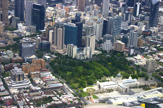
Royal Exhibition Building and Carlton Gardens
Australia · 37.8061° S, 144.9703° E · 1 km from Melbourne
The Royal Exhibition Building and its surrounding Carlton Gardens were designed for the great international exhibitions of 1880 and 1888 in Melbourne. The building and grounds were designed by Joseph Reed. The building is constructed of brick and timber, steel and slate. It combines elements from the Byzantine, Romanesque, Lombardic and Italian Renaissance styles. The property is typical of the international exhibition movement which saw over 50 exhibitions staged between 1851 and 1915 in venues including Paris, New York, Vienna, Calcutta, Kingston (Jamaica) and Santiago (Chile). All shared a common theme and aims: to chart material and moral progress through displays of industry from all nations.
Description from the UNESCO World Heritage Centre (CC BY-SA IGO 3.0).
Why Royal Exhibition Building and Carlton Gardens Is Listed
- (ii)
- An important interchange of human values.

Australian Convict Sites
Australia · 33.3783° S, 150.9944° E · 15 km² · 63 km from Sydney
The Australian Convict Sites are a World Heritage Site that consists of eleven penal sites associated with convict transportation to Australia. The sites were constructed during the 18th and 19th centuries, a period during which around 166,000 people were transported to Australia. Convicts were sent to Australia for a range of offences, including committing petty crimes and supporting particular political causes. Convicts were subjected to forced labour, which was used as a means of deterrence and rehabilitation, and as a way of developing the Australian colonies. Several thousand sites, including prisons and labour facilities, were established across Australia to support the convict system. The eleven designated sites served varied functions, including development of the colony's land and exploitation of its natural resources, deterrence of crime through secondary punishment, and rehabilitation of convicts.
The Australian government began preparing a World Heritage nomination of a series of sites associated with convict transportation in 1995. In 2000, the government of John Howard announced a shortlist of eight sites, which were added to Australia's tentative list.
Adapted from Wikipedia: Australian Convict Sites (CC BY-SA 4.0).
Why Australian Convict Sites Is Listed
- (iv)
- An outstanding example of a type of building or landscape.
- (vi)
- A direct association with events, ideas or beliefs of universal significance.
More about Australian Convict Sites
UNESCO's Description
The property includes a selection of eleven penal sites, among the thousands established by the British Empire on Australian soil in the 18 th and 19 th centuries. The sites are spread across Australia, from Fremantle in Western Australia to Kingston and Arthur's Vale on Norfolk Island in the east; and from areas around Sydney in New South Wales in the north, to sites located in Tasmania in the south. Around 166,000 men, women and children were sent to Australia over 80 years between 1787 and 1868, condemned by British justice to transportation to the convict colonies. Each of the sites had a specific purpose, in terms both of punitive imprisonment and of rehabilitation through forced labour to help build the colony. The Australian Convict Sites presents the best surviving examples of large-scale convict transportation and the colonial expansion of European powers through the presence and labour of convicts.
From the UNESCO World Heritage Centre (CC BY-SA IGO 3.0).

Ningaloo Reef
Australia · 22.7390° S, 113.6280° E · 7,050 km²
The Ningaloo Coast is a World Heritage Site located in the north west coastal region of Western Australia. The 705,015-hectare (1,742,130-acre) heritage-listed area is located approximately 1,200 kilometres (750 mi) north of Perth, along the East Indian Ocean. The distinctive Ningaloo Reef that fringes the Ningaloo Coast is 260 kilometres (160 mi) long and is Australia's largest fringing coral reef and the only large reef positioned very close to a landmass. The Muiron Islands and Cape Farquhar are within this coastal zone.
The reef attracts 200,000 tourists each year. In 2011 and 2025, the reef was hit by bleaching events caused by marine heatwaves.
Adapted from Wikipedia: Ningaloo Coast (CC BY-SA 4.0).
Why Ningaloo Reef Is Listed
- (vii)
- Superlative natural phenomena or exceptional natural beauty.
- (x)
- The most important natural habitats for conserving biodiversity.
More about Ningaloo Reef
UNESCO's Description
The 604,500 hectare marine and terrestrial property of Ningaloo Coast, on the remote western coast of Australia, includes one of the longest near-shore reefs in the world. On land the site features an extensive karst system and network of underground caves and water courses. Annual gatherings of whale sharks occur at Ningaloo Coast, which is home to numerous marine species, among them a wealth of sea turtles. The terrestrial part of the site features subterranean water bodies with a substantial network of caves, conduits, and groundwater streams. They support a variety of rare species that contribute to the exceptional biodiversity of the marine and terrestrial site
From the UNESCO World Heritage Centre (CC BY-SA IGO 3.0).
History
The coast and reef draw their name from the Wajarri language word ningaloo, meaning "promontory", "deep water", or "high land jutting into the sea". The Yamatji peoples of the Baiyungu and Yinigudura are the traditional owners of the area.
The World Heritage status of the region was created and negotiated in 2011, and the adopted boundary included the Ningaloo Marine Park (Commonwealth waters), Ningaloo Marine Park (State waters) and Muiron Islands Marine Management Area (including the Muiron Islands), Jurabi Coastal Park, Bundegi Coastal Park, Cape Range National Park, and the Learmonth Air Weapons Range. The site was gazetted on the Australian National Heritage List on 6 January 2010 under the Environment Protection and Biodiversity Conservation Act 1999.
Description
The World Heritage Site covers 7,050 square kilometres (2,722 mi2), and is located approximately 1,200 kilometres (750 mi) north of Perth, in the East Indian Ocean. The 260-kilometre-long (160 mi) Ningaloo Reef that fringes the Ningaloo Coast is Australia's largest fringing coral reef, and the only large reef positioned very close to a landmass. The Muiron Islands and Cape Farquhar are within this coastal zone.
Although most famed for its whale sharks which feed there during March to August, the reef is also rich in coral and other marine life. During the winter months, the reef is part of the migratory routes for dolphins, dugongs, manta rays and humpback whales. The beaches of the reef are an important breeding ground of the loggerhead, green and hawksbill turtles.
Sections adapted from Wikipedia: Ningaloo Coast (CC BY-SA 4.0).
Key Facts
| Established | 2011 |
|---|---|
| Area | 7,075 km² |
Facts from Wikidata Q1541665 (CC0).
Visiting Ningaloo Reef
Ningaloo Reef or Ningaloo Coast is a marine park and UNESCO World Heritage Site lying off the Gascoyne region of Western Australia. The reef extends 260 km from Exmouth to Red Bluff near Carnarvon. It's renowned for its corals and associated marine life, easily reached by snorkelling from shore or a short boat ride.
Travel notes adapted from Wikivoyage: Ningaloo Coast (CC BY-SA 4.0).
Budj Bim
Australia · 38.0667° S, 141.9170° E · 99 km² · 60 km from Warrnambool
Budj Bim, also known as Mount Eccles, is a dormant volcano near Macarthur in southwestern Victoria, Australia. It lies within the geologically defined area known as the Newer Volcanics Province, which is the youngest volcanic area in Australia and stretches from western Victoria to south-eastern South Australia.
It is situated within the Budj Bim National Park. Budj Bim is the Gunditjmara name, meaning "High Head". The roughly conical peak rises 178 metres (584 ft) above surrounding area. The peak is a scoria hill that was thrown up beside a group of three overlapping volcanic craters that now contain Lake Surprise. A line of smaller craters and scoria cones runs to the southeast. Lava flows extend to form a shield volcano and are fed by several lava channels, or "lava canals" as they are known locally. This lava flow, known as the Tyrendarra lava flow, changed the drainage pattern of the region, and created large wetlands.
Large areas to the west and south-west of the mountain have been heritage-listed.
Adapted from Wikipedia: Budj Bim (CC BY-SA 4.0).
Why Budj Bim Is Listed
- (iii)
- A unique testimony to a cultural tradition or civilisation.
- (v)
- An outstanding example of traditional human settlement or land use.
More about Budj Bim
UNESCO's Description
The Budj Bim Cultural Landscape, located in the traditional Country of the Gunditjmara people in south-eastern Australia, consists of three serial components containing one of the world’s most extensive and oldest aquaculture systems. The Budj Bim lava flows provide the basis for the complex system of channels, weirs and dams developed by the Gunditjmara in order to trap, store and harvest kooyang (short-finned eel – Anguilla australis ). The highly productive aquaculture system provided an economic and social base for Gunditjmara society for six millennia. The Budj Bim Cultural Landscape is the result of a creational process narrated by the Gunditjmara as a deep time story, referring to the idea that they have always lived there. From an archaeological perspective, deep time represents a period of at least 32,000 years. The ongoing dynamic relationship of Gunditjmara and their land is nowadays carried by knowledge systems retained through oral transmission and continuity of cultural practice.
From the UNESCO World Heritage Centre (CC BY-SA IGO 3.0).
Visiting Budj Bim
Budj Bim, also known as Mount Eccles is a national park and a world heritage site in the South West Coast of Victoria.
This article only covers the national park, but the world heritage site also includes the Tyrendarra and Kurtonij. The Tyrendarra IPA is where the most of the archeological remains are found.
Travel notes adapted from Wikivoyage: Budj Bim National Park (CC BY-SA 4.0).

Murujuga National Park
Australia · 20.5753° S, 116.8110° E · 999 km²
Murujuga National Park is a national park on Burrup Peninsula in the Pilbara region in the north-west of Western Australia, covering an area of 48.51 km2 (18.73 sq mi).
Adapted from Wikipedia: Murujuga National Park (CC BY-SA 4.0).
Why Murujuga National Park Is Listed
- (i)
- A masterpiece of human creative genius.
- (iii)
- A unique testimony to a cultural tradition or civilisation.
- (v)
- An outstanding example of traditional human settlement or land use.
More about Murujuga National Park
UNESCO's Description
Murujuga is a deeply storied land and seascape located in northwest Australia. It encompasses the Burrup Peninsula, the Dampier Archipelago, surrounding marine areas and the submerged landscape. Murujuga is shaped by the Lore — rules and narratives put in place to create the Country — and the enduring presence of the Ngarda-Ngarli, Traditional Owners and Custodians of the site. The property holds profound cultural and spiritual significance, reflecting over 50,000 years of continuous care and management by Traditional Law that has adapted to the changing needs of Country over periods of dramatic climatic and environmental change. Murujuga is renowned for its dense concentration of archaeological and spiritual sites that reflect the interaction between people and place over thousands of generations. Its extraordinary rock art assemblage records a complex system of Lore and Traditional Law, features unique motifs and demonstrates artistic and technical mastery.
From the UNESCO World Heritage Centre (CC BY-SA IGO 3.0).
History
Murujuga National Park was officially declared on 17 January 2013 as the 100th national park in Western Australia. The park protects what is considered the world’s highest concentration of ancient petroglyphs, with over ten thousand rock engravings created by the region's Aboriginal peoples.
Description
The national park is located on the northern and western part of the Burrup Peninsula, also known by its Aboriginal name, Murujuga. It lies approximately 200 km (120 mi) west of Port Hedland and 15 km (9.3 mi) north of Karratha, and covers an area of 48.51 km2 (18.73 sq mi). It can be accessed via Dampier Road and Burrup Peninsula Road.
Sections adapted from Wikipedia: Murujuga National Park (CC BY-SA 4.0).
Key Facts
| Established | 2013 |
|---|---|
| Area | 4,851 km² |
Facts from Wikidata Q25386203 (CC0).
Visiting Murujuga National Park
Murujuga National Park is a national park in the Pilbara region of Western Australia. It's home to more than one million images on rock, making it the largest collection of Aboriginal rock art in Australia as well as the world's densest – some of them dating back 47,000 years. The park was established in 2013, and is WA's 100th national park.
Unfortunately, due to its sheer remoteness, the park's significance is not often recognised as such but in 2020, it was added to tentative list for world heritage along with some areas of the Burrup Peninsula surrounding the park under criterion i and iii. The national park, together with the Dampier Archipelago, was listed as a UNESCO World Heritage Site in 2025.
Travel notes adapted from Wikivoyage: Murujuga National Park (CC BY-SA 4.0).
World Heritage in Australia: Quick Answers
- How many UNESCO World Heritage Sites are in Australia?
- Australia has 18 World Heritage Sites: 4 cultural, 10 natural and 4 mixed.
- What was the first World Heritage Site in Australia?
- Great Barrier Reef, inscribed in 1981. The most recent is Murujuga National Park, inscribed in 2025.
- What are the natural World Heritage Sites in Australia?
- Great Barrier Reef, Kakadu National Park (mixed), Willandra Lakes Region (mixed), Lord Howe Island Group, Tasmanian Wilderness (mixed), Gondwana Rainforests of Australia, Uluṟu-Kata Tjuṯa National Park (mixed), Wet Tropics of Queensland, Shark Bay, K'gari, Australian Fossil Mammal Sites (Riversleigh / Naracoorte), Greater Blue Mountains Area, Purnululu National Park, Ningaloo Reef.
- Are any World Heritage Sites in Australia in danger?
- None of the World Heritage Sites in Australia is on UNESCO's List of World Heritage in Danger.