
Map of Papua New Guinea
Papua New Guinea is a country in Oceania with its capital at Port Moresby, home to about 10.76 million people across 462,840 km². The interactive map below plots 23 cities and towns, 4 rivers, 1 lakes, 5 mountain summits and 21 ports recorded for Papua New Guinea in YearMaps.
- Population
- 10.76 million
- Area
- 462,840 km²
- Capital
- Port Moresby
- Continent
- Oceania
Interactive Map of Papua New Guinea
Centred on Port Moresby at 9.4647° S, 147.1925° E. Use the layer panel to switch on rivers, dams, ports, peaks and historical borders.
About Papua New Guinea
Papua New Guinea (PNG), officially the Independent State of Papua New Guinea, is an island nation in Oceania that comprises the eastern half of the island of New Guinea and offshore islands in Melanesia, a region of the southwestern Pacific Ocean north of Australia. It has a land border with Indonesia to the west and maritime borders with Australia to the south and the Solomon Islands to the east. Its capital is Port Moresby. The country's 462,840 km2 (178,700 mi2) includes a large mainland and hundreds of islands.
The eastern half of New Guinea was divided in 1884 between German New Guinea in the north and British New Guinea in the south, with the latter ceded to Australia in 1902 and reorganised as the Territory of Papua. Australia occupied German New Guinea during World War I and then administered the territory as a League of Nations mandate. The nation was the site of fierce fighting during the New Guinea campaign of World War II, following which the two territories were united in 1949. Papua New Guinea was granted independence as a Commonwealth realm in 1975. Representing the monarch is a governor-general. Politics take place within a Westminster system, with the government led by a prime minister. Members of the National Parliament, the unicameral legislative body, also serve as provincial leaders.
The population is highly rural, with only 14% living in urban centres in 2023. The persistence of traditional communities and lifestyles is explicitly protected by the Papua New Guinea Constitution. While official population estimates suggest the population is around 11.8 million, estimates using satellite data put the number closer to 17 million. The population is extremely diverse. There are 840 known spoken languages, making it the most linguistically diverse country in the world. Cultural practices are similarly diverse. Many cultural and linguistic groups are small, although English and Tok Pisin serve as common languages. This diversity has led to friction, especially in politics, and the government has struggled to combat violence against women.
The country has a large Christian majority population, of several different denominations, and in March 2025 its constitution was amended to adopt Christianity as the official state religion.
The rural and diverse population is a result of highly mountainous geography. The land supports around 5% of all known species, and the export-driven economy is also dependent on natural resources.
Summary adapted from Wikipedia: Papua New Guinea (CC BY-SA 4.0).

Geography and Climate of Papua New Guinea
Papua New Guinea (PNG) occupies the eastern half of the island of New Guinea; the western half is part of Indonesia. PNG was first settled between 50,000 and 60,000 years ago. Its harsh geography of mountains, jungles, and numerous river valleys kept many of the arriving groups isolated, giving rise to PNG’s ethnic and linguistic diversity. Around 500 B.C., Austronesian voyagers settled along the coast. Spanish and Portuguese explorers periodically visited the island starting in the 1500s, but none made it into the country’s interior. American and British whaling ships frequented the islands off the coast of New Guinea in the mid-1800s. In 1884, Germany declared a protectorate -- and eventually a colony -- over the northern part of what would become PNG and named it German New Guinea; days later the UK followed suit on the southern part and nearby islands and called it Papua. Most of their focus was on the coastal regions, leaving the highlands largely unexplored. The UK put its colony under Australian administration in 1902 and formalized the act in 1906. At the outbreak of World War I, Australia occupied German New Guinea and continued to rule it after the war as a League of Nations Mandate. The discovery of gold along the Bulolo River in the 1920s led prospectors to venture into the highlands, where they found about 1 million people living in isolated communities. The New Guinea campaign of World War II lasted from January 1942 to the Japanese surrender in August 1945. After the war, Australia combined the two territories and administered PNG as a UN trusteeship. In 1975, PNG gained independence and became a member of the Commonwealth. Between 1988-1997, a secessionist movement on the island province of Bougainville, located off the eastern PNG coast, fought the PNG Government, resulting in 15,000-20,000 deaths. In 1997, the PNG Government and Bougainville leaders reached a cease-fire and subsequently signed a peace agreement in 2001. The Autonomous Bougainville Government was formally established in 2005. Bougainvilleans voted in favor of independence in a 2019 non-binding referendum. The Bougainville and PNG governments are in the process of negotiating a roadmap for independence, which requires approval by the PNG parliament.
- Location
- Oceania, group of islands including the eastern half of the island of New Guinea between the Coral Sea and the South Pacific Ocean, east of Indonesia.
- Climate
- Tropical; northwest monsoon (December to March), southeast monsoon (May to October); slight seasonal temperature variation.
- Terrain
- Mostly mountains with coastal lowlands and rolling foothills.
- Highest point
- Mount Wilhelm 4,509 m.
- Lowest point
- Pacific Ocean 0 m.
- Coastline
- 5,152 km.
- Land borders
- Total: 824 km; border countries: Indonesia 824 km.
- Major rivers
- Sepik river source and mouth (shared with Indonesia) - 1,126 km; Fly river source and mouth (shared with Indonesia) - 1,050 km.
- Natural resources
- Gold, copper, silver, natural gas, timber, oil, fisheries.
- Land use
- Agricultural land: 3.1% (2023 est.); arable land: 0.7% (2023 est.); permanent crops: 2% (2023 est.); permanent pasture: 0.4% (2023 est.); forest: 75.2% (2023 est.); other: 21.7% (2023 est.)
- Natural hazards
- Active volcanism; frequent and sometimes severe earthquakes; mud slides; tsunamis volcanism: severe volcanic activity; Ulawun (2,334 m), one of Papua New Guinea's potentially most dangerous volcanoes, has been deemed a Decade Volcano by the International Association of Volcanology and Chemistry of the Earth's Interior, worthy of study due to its explosive history and close proximity to human populations; Rabaul (688 m) destroyed the city of Rabaul in 1937 and 1994; Lamington erupted in 1951, killing 3,000 people; Manam's 2004 eruption forced the island's abandonment; other historically active volcanoes include Bam, Bagana, Garbuna, Karkar, Langila, Lolobau, Long Island, Pago, St. Andrew Strait, Victory, and Waiowa; see note 2 under "Geography - note".
- Geographic note
- Note 1: shares island of New Guinea with Indonesia; highlands that trend from east to west break up New Guinea into diverse ecoregions; one of world's largest swamps lies along the southwest coast note 2: Papua New Guinea is one of the countries along the Ring of Fire, which is a belt bordering the Pacific Ocean that contains about 75% of the world's volcanoes and up to 90% of the world's earthquakes.
- Languages
- Tok Pisin (official), English (official), Hiri Motu (official), some 839 living indigenous languages are spoken (about 12% of the world's total)
- Religions
- Protestant 64.3% (Evangelical Lutheran 18.4%, Seventh Day Adventist 12.9%, Pentecostal 10.4%, United Church 10.3%, Evangelical Alliance 5.9%, Anglican 3.2%, Baptist 2.8%, Salvation Army 0.4%), Roman Catholic 26%, other Christian 5.3%, non-Christian 1.4%, unspecified 3.1% (2011 est.)
- Ethnic groups
- Melanesian, Papuan, Negrito, Micronesian, Polynesian.
- Economy
- Lower-middle-income Pacific island economy; primarily informal agrarian sector; natural-resource-rich and key exporter of liquified natural gas; collapse in betel nut prices, tighter monetary policy, and improved foreign-exchange availability contributing to declining inflation; challenges include lack of progress in infrastructure, agricultural reform, and corruption.
From the CIA World Factbook (public domain), archived edition of 2026-01-22. The Factbook is no longer updated, so figures reflect that edition.
Papua New Guinea in Numbers
- Population
- 10.76 million
- GDP
- US$32.5 billion
- GDP per person
- US$3,020
- Life expectancy
- 66.3 years
- Population growth
- 1.75% a year
- Population density
- 23 per km²
- Urban population
- 15.8%
- Surface area
- 462,840 km²
- Forest cover
- 75.2%
- Arable land
- 0.7%
- Access to electricity
- 43.3%
- Internet users
- 18.8%
Indicators from World Bank Open Data (CC BY 4.0). The year under each figure is its reference year.
Papua New Guinea in Depth
History
Archaeological evidence indicates that modern humans first arrived in what became New Guinea and Australia, as well as the Bismarck Archipelago, around 42,000 to 45,000 years ago. Bougainville was settled by around 28,000 years ago, and the more distant Manus Island by around 20,000 years ago. These were part of the earliest migrations of humans from Africa, and the resulting populations remained relatively isolated from the rest of the world throughout prehistory. Rising sea levels isolated New Guinea from Australia about 10,000 years ago, although Aboriginal Australians and New Guineans had already diverged from each other from about 37,000 years ago.
Geography
Papua New Guinea extends over 462,840 km2 (178,704 sq mi), including a large mainland and a number of islands. The country lies just south of the equator, and shares a land border with Indonesia, and maritime borders with Australia, the Solomon Islands, and the Federated States of Micronesia. The island of New Guinea lies at the east of the Malay Archipelago. The country is separated from Australia's Cape York Peninsula by the shallow 152-kilometre (94 mi) Torres Strait. To the west of this strait is the shallow Arafura Sea, while to its east is the much deeper Coral Sea. The Gulf of Papua covers much of the southern coast, while the Solomon Sea lies east of the mainland.
Economy
Papua New Guinea is classified as a developing economy by the International Monetary Fund. The economy is largely dependent on natural resources, with capital investment concentrated in mining and oil, while most labour is employed in agriculture. As of 2018, natural resource extraction made up 28% of overall GDP, with substantial contributors including minerals, oil, and natural gas. Measuring economic growth is difficult due to the resource-dependent economy distorting GDP. Other metrics such as Gross national income are hard to measure. Even historical GDP estimates have changed dramatically. As of 2019, PNG's real GDP growth rate was 3.8%, with an inflation rate of 4.3%.
Demographics
Papua New Guinea is one of the most heterogeneous nations in the world. In addition to having perhaps a quarter of the world's languages, ethnic identity within the country is further divided by factors such as geography, kinship ties, and external pressures. The United Nations Department of Economic and Social Affairs population estimate as of 2020 was 8.95 million inhabitants. Government estimates put the population at 11.8 million in 2021. With the National Census deferred during 2020/2021, ostensibly on the grounds of the COVID-19 pandemic, an interim assessment was conducted using satellite imagery.
Sections adapted from Wikipedia: Papua New Guinea (CC BY-SA 4.0).
Papua New Guinea: Key Facts
| Currency | kina |
|---|---|
| Official languages | English, Tok Pisin, Hiri Motu, Papua New Guinean Sign Language |
| Head of state | Charles III |
| Head of government | James Marape |
| Calling code | +675 |
| Internet domain | .pg |
| Highest point | Mount Wilhelm |
| Lowest point | Pacific Ocean |
| Established | 1975 |
Facts from Wikidata Q691 (CC0).
History of Papua New Guinea: Empires and States
The atlas records 4 polities whose mapped territory included part of Papua New Guinea, from German Empire in 1885 CE to 2024 CE. They are listed in the order they first appear.
| Polity | Period here | Extent |
|---|---|---|
| German Empire | 1885–1914 CE | A large part |
| British Colonial Empire | 1885–1945 CE | A large part |
| The British Empire | 1885–1945 CE | A large part |
| Papua New Guinea | 1946–2024 CE | A large part |
Historical Maps of Papua New Guinea
Papua New Guinea on the world map in each year one of these states held it:
Derived by testing mapped cities against dated territorial polygons. Dates are when the polygons cover this place, not the polity's whole lifespan, and polities absent from the source dataset are not listed.
Visiting Papua New Guinea
The Independent State of Papua New Guinea (PNG, Tok Pisin: Papua Niugini, Hiri Motu: Papua Niu Gini) comprises the eastern part of the world's largest and highest tropical island, New Guinea, together with many smaller offshore islands.
Travel notes adapted from Wikivoyage: Papua New Guinea (CC BY-SA 4.0).
Largest Cities in Papua New Guinea
23 cities recorded. Ranked by metropolitan population. A port city's harbour is written up on the page of its sea.
| # | Name | Population | Region | Role |
|---|---|---|---|---|
| 1 | Port Moresby | 283,733 | Central | National capital |
| 2 | Lae | 131,052 | Morobe | Admin-1 capital |
| 3 | Madang | 62,023 | Madang | Admin-1 capital |
| 4 | Mount Hagen | 59,064 | Western Highlands | Admin-1 capital |
| 5 | Arawa | 40,266 | North Solomons | Admin-1 capital |
| 6 | Goroka | 39,699 | Eastern Highlands | Admin-1 capital |
| 7 | Popondetta | 28,198 | Northern | Admin-1 capital |
| 8 | Mendi | 26,252 | Southern Highlands | Admin-1 capital |
| 9 | Wewak | 25,143 | East Sepik | Admin-1 capital |
| 10 | Kavieng | 19,728 | New Ireland | Admin-1 capital |
| 11 | Kimbe | 18,847 | West New Britain | Admin-1 capital |
| 12 | Daru | 15,214 | — | Admin-1 capital |
| 13 | Alotau | 11,624 | Milne Bay | Admin-1 capital |
| 14 | Vanimo | 11,204 | Sandaun | Admin-1 capital |
| 15 | Kundiawa | 9,383 | Chimbu | Admin-1 capital |
| 16 | Rabaul | 8,074 | East New Britain | Admin-1 capital |
| 17 | Kieta | 6,958 | North Solomons | Populated place |
| 18 | Lorengau | 5,806 | Manus | Admin-1 capital |
| 19 | Kerema | 5,646 | Gulf | Admin-1 capital |
| 20 | Wabag | 3,958 | Enga | Admin-1 capital |
| 21 | Sohano | 2,338 | North Solomons | Populated place |
| 22 | Hoskins | 871 | West New Britain | Populated place |
| 23 | Abau | 230 | Central | Populated place |
Highest Mountains in Papua New Guinea
5 mountains recorded. Ranked by summit elevation above sea level. A summit on a border is listed under both countries.
| # | Name | Elevation | Feet | Region |
|---|---|---|---|---|
| 1 | Mount Wilhelm | 4,509 m | 14,793 ft | Oceania |
| 2 | Mount Victoria | 4,038 m | 13,248 ft | Oceania |
| 3 | Mount Balbi | 2,715 m | 8,907 ft | Oceania |
| 4 | Ulawun | 2,334 m | 7,657 ft | Oceania |
| 5 | Takuan | 2,243 m | 7,359 ft | Oceania |
Largest Lakes in Papua New Guinea
1 lake recorded. Ranked by mapped surface area. A lake on a border is listed under each country it lies in, with the area of the whole lake.
| # | Name | Surface Area | Type |
|---|---|---|---|
| 1 | Lake Murray | 410 km² | Lake |
Rivers in Papua New Guinea
4 rivers recorded. Listed alphabetically. A river is listed where its mapped reach lies, so long rivers appear under more than one country.
Ports in Papua New Guinea
21 ports recorded. Ranked by approach channel depth, the figure that limits which ships can call. Harbours link to their write-up on the page of the sea or coast they lie on.
| # | Name | Channel Depth | Class | Sea | Max Vessel |
|---|---|---|---|---|---|
| 1 | Alotoa | 45.7 m | Very Small | Pacific Islands & Hawaii | medium vessels |
| 2 | Samarai | 42.1 m | Very Small | Pacific Islands & Hawaii | point_of_interest |
| 3 | Port Moresby | 38.4 m | Small | Pacific Islands & Hawaii | medium vessels |
| 4 | Madang | 38.4 m | Very Small | Pacific Islands & Hawaii | medium vessels |
| 5 | Vanimo | 38.4 m | Small | Pacific Islands & Hawaii | medium vessels |
| 6 | Discovery Bay | 34.7 m | Very Small | Pacific Islands & Hawaii | point_of_interest |
| 7 | Oro Bay | 34.7 m | Very Small | Pacific Islands & Hawaii | medium vessels |
| 8 | Longan Island | 34.7 m | Very Small | Pacific Islands & Hawaii | point_of_interest |
| 9 | Lae | 34.7 m | Very Small | Pacific Islands & Hawaii | medium vessels |
| 10 | Hamburg Harbor | 31.1 m | Very Small | Pacific Islands & Hawaii | medium vessels |
The other 11 (channel depth, class, sea, max vessel)
- Wewak Harbor · 23.8 m · Small · Pacific Islands & Hawaii · medium vessels
- Queen Carola Harbor · 20.1 m · Very Small · Pacific Islands & Hawaii · medium vessels
- Kavieng Harbor · 20.1 m · Small · Pacific Islands & Hawaii · medium vessels
- Suloga Harbor · 5.5 m · Very Small · Pacific Islands & Hawaii · point_of_interest
- Kokopo · 5.5 m · Very Small · Pacific Islands & Hawaii · point_of_interest
- Rabaul · 5.5 m · Small · Pacific Islands & Hawaii · medium vessels
- Kieta · 5.5 m · Small · Pacific Islands & Hawaii · large vessels
- Kumul · Very Small · Pacific Islands & Hawaii · large vessels
- Kimbe · Very Small · Pacific Islands & Hawaii · medium vessels
- Bialla · Very Small · Pacific Islands & Hawaii · point_of_interest
- Lorengau · Very Small · Pacific Islands & Hawaii · medium vessels
UNESCO World Heritage Sites in Papua New Guinea
1 World Heritage Site recorded. Listed by year of inscription, earliest first. Sites shared with another country appear under each.
| # | Name | Inscribed | Type | Criteria |
|---|---|---|---|---|
| 1 | Kuk Swamp | 2008 | Cultural | (iii) (iv) |
Largest Islands of Papua New Guinea
10 islands recorded. Ranked by mapped area. An island divided between countries is listed under each, with the area of the whole island.
| # | Name | Area | Type |
|---|---|---|---|
| 1 | New Guinea | 785,443 km² | Island |
| 2 | Bismarck Archipelago | 534,907 km² | Island group |
| 3 | New Britain | 35,988 km² | Island group |
| 4 | Louisiade Archipelago | 17,183 km² | Island group |
| 5 | D’Entrecasteaux Islands | 12,017 km² | Island group |
| 6 | Bougainville | 8,751 km² | Island group |
| 7 | New Ireland | 6,961 km² | Island group |
| 8 | Manus | 1,853 km² | Island |
| 9 | Mussau | 416 km² | Island |
| 10 | Karkar | 371 km² | Island |
Mountain Ranges, Deserts and Landforms of Papua New Guinea
2 mountain ranges, deserts and other landforms recorded. Ranked by mapped area. Covers mountain ranges, deserts, plateaus, named glaciers, plains, basins, peninsulas and capes. One that crosses a border is listed under every country it lies in, with the area of the whole feature.
| # | Name | Area | Type | Region |
|---|---|---|---|---|
| 1 | New Guinea Highlands | 222,321 km² | Range/mtn | Oceania |
| 2 | Owen Stanley Range | 5,592 km² | Range/mtn | Oceania |

New Guinea Highlands
Range/mtn · 222,321 km²
New Guinea Highlands is a range/mtn in Oceania (Melanesia), covering an estimated 222,321 km². It extends across Papua New Guinea and Indonesia. It is the 13th-largest of the 216 mountain ranges with a mapped extent in YearMaps.
The New Guinea Highlands, also known as the Central Range or Central Cordillera, is a long chain of mountain ranges on the island of New Guinea, including the island's highest peak, Puncak Jaya, Indonesia, 16,024 ft (4,884 m), the highest mountain in Oceania. The range is home to many intermountain river valleys, many of which support thriving agricultural communities. The highlands run generally east-west the length of the island, which is divided politically between Indonesia in the west and Papua New Guinea in the east. These mountains stretch from the Weyland Mountains starting in Wondama Bay Regency in the west to the Milne Bay Province in the east.
Adapted from Wikipedia: New Guinea Highlands (CC BY-SA 4.0).
- Feature class
- Range/mtn
- Mapped extent
- 222,321 km²
- Size rank
- #13 of 216 mountain ranges
- Region
- Oceania
- Subregion
- Melanesia
- Countries
- Papua New Guinea, Indonesia
- Coordinates
- -5.7013°, 143.9361°
- Summits:
- Mount Wilhelm (4,509 m), Ulawun (2,334 m), Mount Balbi (2,715 m)
- Adjacent ranges:
- Owen Stanley Range (Oceania), Maoke Mountains (Oceania)
- Settlements:
- Mount Hagen (67 km), Goroka (95 km), Mendi (105 km)
More about New Guinea Highlands
Geography
The Central Cordillera, some peaks of which are capped with ice, consists of (from east to west): the Central Highlands and Eastern Highlands of Papua New Guinea including the Owen Stanley Range in the southeast, whose highest peak is Mount Victoria at 4,038 metres (13,248 feet), the Albert Victor Mountains, the Sir Arthur Gordon Range, and the Bismarck Range, whose highest peak is Mount Wilhelm at 4,509 metres (14,793 feet), which is an extinct volcano with a crater lake; the Star Mountains on the Papua New Guinea–Indonesia border; and the Maoke Mountains or Snow Range in Indonesia, where perpetual snow was found by H. A. Lorentz in 1909 at 4,461 m (14,635 ft), and whose highest peaks are Puncak Jaya (Mt. Carstensz) at 4,884 m (16,024 feet), Puncak Mandala (Mt. Juliana) at 4,760 m (15,610 ft) and Puncak Trikora (Mt. Wilhelmina) at 4,750 m (15,580 ft).
Geology
This chain of mountains continues to rise (with corresponding quakes) as the Australian Plate collides with the plates to the northeast, marking the southern boundaries of the Maoke and Woodlark plates. The width of the mountain range varies considerably, with a central thin segment near the borders of the two nations.
The surface geology of the highlands is made up of metamorphic and intrusive igneous rocks. The metamorphic rocks were Cretaceous and Eocene ocean sediments that were uplifted and folded between the Eocene and early Miocene periods. There are also Pleistocene stratovolcanoes in the highlands, including Mount Hagen and Mount Giluwe.
Ecology
The New Guinea Highlands are home to a great variety of Australasian plant and animal communities, distinct from the surrounding lowlands to the north and south of the central ranges and varying up and along the mountain ranges. The habitats of the mountains have been separated into two ecoregions, depending on their elevation, the tropical montane forests and alpine grasslands, but within these broad bands there is a variety of wildlife along the island as some of the mountains stand quite a distance from others with some species of plant or animal existing on only one or two mountains.
History
The fertile Highlands have long been inhabited and artifacts uncovered in the Ivane Valley indicate that the Highlands were first settled about 50,000 years ago. The inhabitants were nomadic foragers but around 10,000 years ago began developing a fairly advanced agricultural society. Before the introduction of the sweet potato, the Highlands had distinct forms of division of labor. In the Eastern Highlands the economy was mixed, with men hunting and cultivating, and women gathering and tending crops. Populations were small, dispersed, and focused on immediate consumption.
Sections adapted from Wikipedia: New Guinea Highlands (CC BY-SA 4.0).
New Guinea Highlands: Key Facts
| Highest point | Puncak Jaya |
|---|
Facts from Wikidata Q2961771 (CC0).
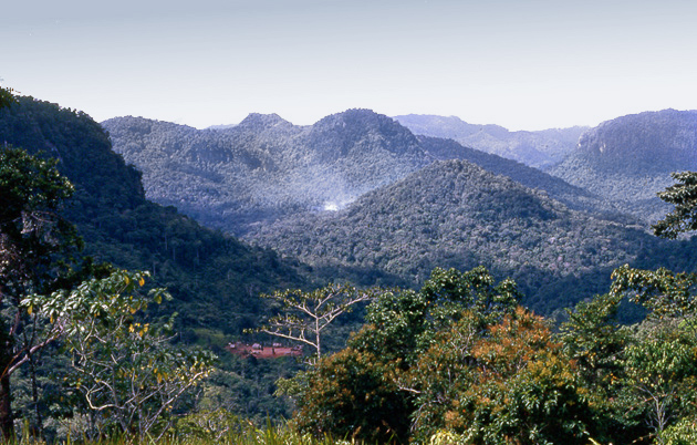
Owen Stanley Range
Range/mtn · 5,592 km²
Owen Stanley Range is a range/mtn in Oceania (Melanesia), covering an estimated 5,592 km².
The Owen Stanley Range is the south-eastern part of the central mountain-chain in Papua New Guinea. Its highest point is Mount Victoria at 4,038 metres (13,248 ft), while its most prominent peak is Mount Suckling.
Adapted from Wikipedia: Owen Stanley Range (CC BY-SA 4.0).
- Feature class
- Range/mtn
- Mapped extent
- 5,592 km²
- Size rank
- #160 of 216 mountain ranges
- Region
- Oceania
- Subregion
- Melanesia
- Coordinates
- -9.9325°, 149.3231°
- Summits:
- Ulawun (2,334 m), Mount Wilhelm (4,509 m), Mount Balbi (2,715 m)
- Adjacent ranges:
- New Guinea Highlands (Oceania), Great Dividing Range (Oceania)
- Settlements:
- Popondetta (175 km), Port Moresby (239 km), Lae (439 km)
More about Owen Stanley Range
Geography
The range is flanked by broken and difficult country, particularly on the south-western side. There are few practicable passes, the easiest being the famous Kokoda Track which crosses the range between Port Moresby and Buna and was in use for more than 50 years as a regular overland mail-route. Another route used by the 900 men of the US 2nd Battalion, 126th Infantry Regiment, 32nd Division, was the Kapa Kapa Trail, parallel to but 50 kilometres (30 mi) to the southeast of the Kokoda Track. They took nearly five weeks to cover the 210 kilometres (130 mi) track over extraordinarily difficult jungle terrain, from 14 October to 20 November 1942.
Immense ridges, or "razorbacks," followed each other in succession like the teeth of a saw.
History
Owen Stanley Range was seen in 1849 by Captain Owen Stanley aboard HMS Rattlesnake while surveying the south coast of Papua and named after him, although he saw them only from his ship. The eastern extremity of the range is Mount Victoria, which was climbed by Sir William MacGregor in 1888, and it extends as far west as Mount Thynne and Lilley. But the name is generally used to denote the whole of the chain of the Papuan Peninsula, from Mount Chapman 3,376 metres (11,076 ft) to the south-eastern end of the island, and to include Mount Albert Edward 3,990 m (13,091 ft) which is really separated from it by the Wharton Chain.
Sections adapted from Wikipedia: Owen Stanley Range (CC BY-SA 4.0).
Owen Stanley Range: Key Facts
| Highest point | Mount Victoria |
|---|---|
| Part of | Bismarck Range |
Facts from Wikidata Q633771 (CC0).
Countries Bordering Papua New Guinea
Land and maritime neighbours.
More Maps in Oceania
Papua New Guinea: Quick Answers
- What is the capital of Papua New Guinea?
- The capital of Papua New Guinea is Port Moresby.
- What is the population of Papua New Guinea?
- Papua New Guinea has a population of about 10.76 million, the #92 largest of 225 countries in YearMaps. Source: World Bank, 2025.
- How big is Papua New Guinea?
- Papua New Guinea covers 462,840 km², ranking #55 by area, with about 23 people per square kilometre.
- Which continent is Papua New Guinea in?
- Papua New Guinea is in Oceania.
- Which countries border Papua New Guinea?
- Papua New Guinea shares a land or maritime border with Indonesia, Australia, Solomon Islands, Micronesia.
- What is the largest city in Papua New Guinea?
- Port Moresby is the largest city in Papua New Guinea, with a metropolitan population of about 283,733.
- What is the highest mountain in Papua New Guinea?
- The highest summit recorded for Papua New Guinea in YearMaps is Mount Wilhelm at 4,509 m (14,793 ft). Summits on a border are counted for both countries.
- What is the largest lake in Papua New Guinea?
- The largest lake recorded in or bordering Papua New Guinea is Lake Murray, at roughly 410 km².