
Map of Greenland
Greenland is a country in North America with its capital at Nuuk, home to about 56,831 people across 2.17M km². The interactive map below plots 22 cities and towns, 4 mountain summits and 17 ports recorded for Greenland in YearMaps.
- Population
- 56,831
- Area
- 2.17M km²
- Capital
- Nuuk
- Continent
- North America
Interactive Map of Greenland
Centred on Nuuk at 64.1983° N, 51.7327° W. Use the layer panel to switch on rivers, dams, ports, peaks and historical borders.
About Greenland
Greenland is an autonomous territory of the Kingdom of Denmark and is the largest of the kingdom's three constituent parts by land area, the others being Denmark proper and the Faroe Islands. Citizens of Greenland are citizens of Denmark. They are thus citizens of the European Union (EU), although Greenland is not part of the EU. It is the world's largest island and lies between the Arctic and Atlantic oceans, east of the Canadian Arctic Archipelago. It shares a small 1.2-kilometre (0.75 mi) border with Canada on Hans Island. The capital and largest city is Nuuk. Kaffeklubben Island off the northern coast is the world's northernmost undisputed point of land – Cape Morris Jesup on the main island was thought to be so until the 1960s. Economically, Greenland is heavily reliant on aid from Denmark, which has averaged 5.4 billion kr. (€724 million) annually in the period 2019–2023, amounting to more than 20% of the territory's gross domestic product.
Though a part of the continent of North America, Greenland was politically and culturally associated with the European kingdom of Norway from 986 until the early 15th century. From the 18th century, following the union of Denmark and Norway and the establishment of the Nuuk settlement, Greenland gradually became associated with Denmark. Greenland has been inhabited at intervals over at least the last 4,500 years by circumpolar peoples whose forebears migrated there from what is now Canada. Norsemen from Norway settled the uninhabited southern part of Greenland beginning in the 10th century (having previously settled Iceland), and their descendants lived in Greenland for 400 years until disappearing in the late 15th century. From the late 15th century, the Portuguese attempted to find the northern route to Asia, which ultimately led to the earliest cartographic depiction of the coastline. In the 17th century, Dano-Norwegian explorers reached Greenland again, finding their earlier settlement extinct and reestablishing a permanent Scandinavian presence.
When Denmark and Norway separated in 1814, Greenland was transferred from the Norwegian to the Danish crown. The 1953 Constitution of Denmark ended Greenland's status as a colony, integrating it fully into the Danish state. In the 1979 Greenlandic home rule referendum, Denmark granted home rule to Greenland. In the 2008 Greenlandic self-government referendum, Greenlanders voted for the Self-Government Act which transferred more power from the Danish government to the local Naalakkersuisut (Greenlandic government).
Summary adapted from Wikipedia: Greenland (CC BY-SA 4.0).

Geography and Climate of Greenland
Greenland, the world's largest island, is about 80% ice capped. The Inuit came to Greenland from North America in a series of migrations that stretched from 2500 BC to the11th century. Vikings reached the island in the 10th century from Iceland; Danish colonization began in the 18th century, and Greenland became part of the Kingdom of Denmark in 1953. It joined the European Community (now the EU) with Denmark in 1973 but withdrew in 1985 over a dispute centered on stringent fishing quotas. Greenland remains a member of the EU's Overseas Countries and Territories Association. The Danish parliament granted Greenland home rule in 1979; the law went into effect the following year. Greenland voted in favor of self-government in 2008 and acquired greater responsibility for internal affairs when the Act on Greenland Self-Government was signed into law in 2009. The Kingdom of Denmark, however, continues to exercise control over several policy areas on behalf of Greenland, including foreign affairs, security, and financial policy, in consultation with Greenland's Self-Rule Government.
- Location
- Northern North America, island between the Arctic Ocean and the North Atlantic Ocean, northeast of Canada.
- Climate
- Arctic to subarctic; cool summers, cold winters.
- Terrain
- Flat to gradually sloping icecap covers all but a narrow, mountainous, barren, rocky coast.
- Highest point
- Gunnbjorn Fjeld 3,694 m.
- Lowest point
- Atlantic Ocean 0 m.
- Coastline
- 44,087 km.
- Land borders
- Total: 0 km.
- Natural resources
- Coal, iron ore, lead, zinc, molybdenum, diamonds, gold, platinum, niobium, tantalite, uranium, fish, seals, whales, hydropower, possible oil and gas.
- Land use
- Agricultural land: 0.6% (2023 est.); arable land: 0% (2022 est.); permanent crops: 0% (2022 est.); permanent pasture: 0.6% (2023 est.); forest: 0% (2023 est.); other: 99.4% (2023 est.)
- Natural hazards
- Continuous permafrost over northern two-thirds of the island.
- Geographic note
- Dominates North Atlantic Ocean between North America and Europe; sparse population confined to small settlements along coast; close to one-quarter of the population lives in the capital, Nuuk; world's second largest ice sheet after that of Antarctica, covering an area of 1.71 million sq km (660,000 sq mi), or about 79% of the island, and containing 2.85 million cu km (684 thousand cu mi) of ice (almost 7% of the world's fresh water)
- Languages
- Greenlandic, Danish, English.
- Religions
- Evangelical Lutheran, traditional Inuit spiritual beliefs.
- Ethnic groups
- Greenlandic 88.1%, Danish 7.1%, Filipino 1.6%, other Nordic peoples 0.9%, and other 2.3% (2024 est.)
- Economy
- High-income, self-governing Danish territorial economy; non-EU member but preferential market access; dependent on Danish financial support; exports led by fishing industry; growing tourism and interest in untapped mineral deposits; relies on hydropower for fuel.
From the CIA World Factbook (public domain), archived edition of 2026-01-22. The Factbook is no longer updated, so figures reflect that edition.
Greenland in Numbers
- Population
- 56,831
- GDP
- US$3.3 billion
- GDP per person
- US$58,499
- Life expectancy
- 70.3 years
- Population growth
- -0.01% a year
- Population density
- 0 per km²
- Urban population
- 88.6%
- Surface area
- 410,449 km²
- Forest cover
- 0.0%
- Access to electricity
- 100.0%
- Internet users
- 69.5%
Indicators from World Bank Open Data (CC BY 4.0). The year under each figure is its reference year.
Greenland in Depth
History
In prehistoric times, Greenland was home to several successive Palaeo-Inuit cultures known primarily through archaeological finds. The earliest entry of the Palaeo-Inuit into Greenland is thought to have occurred about 2500 BC. From about 2500 BC to 800 BC, southern and western Greenland was inhabited by the Saqqaq culture. Most finds of remains from that period have been around Disko Bay, including the site of Saqqaq, for which the culture is named.
From 2400 BC to 1300 BC, the Independence I culture existed in northern Greenland. It was a part of the Arctic small-tool tradition. Towns including Deltaterrasserne appeared. About 800 BC the Saqqaq culture disappeared, and the Early Dorset culture emerged in western Greenland and the Independence II culture in northern Greenland.
Geography
Greenland is the world's largest non-continental island and the third largest area in North America after Canada and the United States. It lies between latitudes 59° and 83°N, and longitudes 11° and 74°W, with over 80% of its land mass north of the Arctic Circle. It is bordered by the Arctic Ocean to the north, the Greenland Sea to the east, the North Atlantic Ocean to the southeast, the Davis Strait to the southwest, Baffin Bay to the west, and the Nares Strait and Lincoln Sea to the northwest. The nearest countries are Canada, with which it shares a maritime border to the west and southwest across Nares Strait and Baffin Bay, as well as a shared land border on Hans Island; and Iceland to the southeast.
Economy
The single most important factor in the economy is financial aid from Denmark, mainly in the form of the bloktilskud (block grant). In 2024, the bloktilskud was 4.3 billion kr, amounting to a third of the public revenue. On top of this, the Danish state covered the expenses for i.a. judiciary and defence, which together were estimated to amount to over 1 billion kr. For the period from 2019 to 2023 Danish financial aid to Greenland averaged 5.4 billion kr. (€724 million) a year, amounting to more than 20% of the territory's GDP, up from 3.6 billion kr. in 2009.
GDP in 2023 was DKK 22.9 billion, and GDP per capita was DKK 405,000, equivalent to that of the average economies of Europe. The economy performed well in the early 2020s, despite the pandemic, energy crisis and war in Europe.
Demographics
In 2025, Greenland had a population of 56,542. Of these, 49,738 people, or 88% of the population, were born in Greenland, while the remaining 6,804 were born outside Greenland. That year, 19,905 people resided in Nuuk. Nearly all Greenlanders live along the fjords in the south-west of the main island, which has a relatively mild climate, especially considering the high latitude upon which it lies.
Sections adapted from Wikipedia: Greenland (CC BY-SA 4.0).
Greenland: Key Facts
| Currency | Danish krone |
|---|---|
| Official language | Greenlandic |
| Head of state | Frederik X of Denmark |
| Head of government | Jens-Frederik Nielsen |
| Form of government | parliamentary monarchy |
| Calling code | +299 |
| Internet domain | .gl |
| Highest point | Gunnbjørn Fjeld |
Facts from Wikidata Q223 (CC0).
History of Greenland: Empires and States
The atlas records 2 polities whose mapped territory included part of Greenland, from Greenland in 1741 CE to 2024 CE. They are listed in the order they first appear.
| Polity | Period here | Extent |
|---|---|---|
| Greenland | 1741–1940 CE | A large part |
| Denmark | 1946–2024 CE | A large part |
Historical Maps of Greenland
Greenland on the world map in each year one of these states held it:
Derived by testing mapped cities against dated territorial polygons. Dates are when the polygons cover this place, not the polity's whole lifespan, and polities absent from the source dataset are not listed.
Visiting Greenland
Greenland (Greenlandic: Kalaallit Nunaat; Danish: Grønland) is the world's largest non-continental island, in the Arctic far north-east of North America. For thousands of years this icy landmass has been inhabited by Arctic peoples. In the 10th century, it was settled by Vikings (or at least a small part of it was), and to this day it is part of the Danish Realm.
Travel notes adapted from Wikivoyage: Greenland (CC BY-SA 4.0).
Largest Cities in Greenland
22 cities recorded. Ranked by metropolitan population. A port city's harbour is written up on the page of its sea.
| # | Name | Population | Region | Role |
|---|---|---|---|---|
| 1 | Nuuk | 14,798 | Kommuneqarfik Sermersooq | Admin-0 region capital |
| 2 | Sisimiut | 5,227 | Qeqqata Kommunia | Populated place |
| 3 | Ilulissat | 4,413 | Qaasuitsup Kommunia | Populated place |
| 4 | Qaqortoq | 3,224 | Kommune Kujalleq | Populated place |
| 5 | Paamiut | 1,862 | Kommuneqarfik Sermersooq | Populated place |
| 6 | Tasiilaq | 1,829 | — | Populated place |
| 7 | Qasigiannguit | 1,341 | Qaasuitsup Kommunia | Populated place |
| 8 | Uummannaq | 1,299 | — | Populated place |
| 9 | Upernavik | 1,129 | Qaasuitsup Kommunia | Populated place |
| 10 | Qaanaaq | 616 | Qaasuitsup Kommunia | Admin-1 capital |
| 11 | Kangerlussuaq | 556 | Qeqqata Kommunia | Populated place |
| 12 | Ittoqqortoormiit | 469 | Kommuneqarfik Sermersooq | Populated place |
| 13 | Kullorsuaq | 450 | — | Populated place |
| 14 | Kulusuk | 286 | Kommuneqarfik Sermersooq | Populated place |
| 15 | Tasiusaq | 250 | — | Populated place |
| 16 | Nuussuaq | 204 | Qaasuitsup Kommunia | Populated place |
| 17 | Kangersuatsiaq | 200 | — | Populated place |
| 18 | Narsarsuaq | 145 | Kommune Kujalleq | Populated place |
| 19 | Savissivik | 66 | — | Populated place |
| 20 | Timmiarmiut | 10 | Kommune Kujalleq | Populated place |
| 21 | Nord | 10 | Nationalparken | Populated place |
| 22 | Qeqertasuaq | 10 | Qaasuitsup Kommunia | Populated place |
Highest Mountains in Greenland
4 mountains recorded. Ranked by summit elevation above sea level. A summit on a border is listed under both countries.
| # | Name | Elevation | Feet | Region |
|---|---|---|---|---|
| 1 | Gunnbjørn Fjeld | 3,694 m | 12,119 ft | North America |
| 2 | Mount Forel | 3,360 m | 11,024 ft | North America |
| 3 | Summit Station | 3,238 m | 10,623 ft | North America |
| 4 | Perserajoq | 2,259 m | 7,411 ft | North America |
Ports in Greenland
17 ports recorded. Ranked by approach channel depth, the figure that limits which ships can call. Harbours link to their write-up on the page of the sea or coast they lie on.
| # | Name | Channel Depth | Class | Sea | Max Vessel |
|---|---|---|---|---|---|
| 1 | Paamuit (Frederikshab) | 45.7 m | Small | Arctic Canada, Hudson Bay & Greenland | medium vessels |
| 2 | Qasigiannguit-Christianshab | 42.1 m | Very Small | Arctic Canada, Hudson Bay & Greenland | medium vessels |
| 3 | Illulissat (Jakobshavn) | 34.7 m | Small | Arctic Canada, Hudson Bay & Greenland | medium vessels |
| 4 | Kusanartoq | 31.1 m | Small | Arctic Canada, Hudson Bay & Greenland | medium vessels |
| 5 | Nuuk | 16.5 m | Small | Arctic Canada, Hudson Bay & Greenland | medium vessels |
| 6 | Gronnedal (Kangilinnguit) | 5.5 m | Very Small | Arctic Canada, Hudson Bay & Greenland | medium vessels |
| 7 | Qutdleq | 5.5 m | Very Small | Arctic Canada, Hudson Bay & Greenland | medium vessels |
| 8 | Nanortalik Havn | 5.5 m | Very Small | Arctic Canada, Hudson Bay & Greenland | medium vessels |
| 9 | Narsaq | 5.5 m | Very Small | Arctic Canada, Hudson Bay & Greenland | medium vessels |
| 10 | Maniitsoq | 5.5 m | Very Small | Arctic Canada, Hudson Bay & Greenland | medium vessels |
The other 7 (channel depth, class, sea, max vessel)
- Attu · 5.5 m · Very Small · Arctic Canada, Hudson Bay & Greenland · medium vessels
- Aasiaat · 5.5 m · Small · Arctic Canada, Hudson Bay & Greenland · medium vessels
- Kajalleq Upernavik · 5.5 m · Very Small · Arctic Canada, Hudson Bay & Greenland · point_of_interest
- Pituffik (Thule Air Base) · 5.5 m · Very Small · Arctic Canada, Hudson Bay & Greenland · large vessels
- Sisimiut · 5.5 m · Small · Arctic Canada, Hudson Bay & Greenland · medium vessels
- Narsarssuaq · 5.5 m · Very Small · Arctic Canada, Hudson Bay & Greenland · medium vessels
- Qeqertarsuaq · 5.5 m · Small · Arctic Canada, Hudson Bay & Greenland · medium vessels
Largest Islands of Greenland
2 islands recorded. Ranked by mapped area. An island divided between countries is listed under each, with the area of the whole island.
| # | Name | Area | Type |
|---|---|---|---|
| 1 | Greenland | 343,888 km² | Island |
| 2 | Qeqertarsuaq | 8,772 km² | Island |
Greenland
Island · 343,888 km²
Greenland is an island in North America (Greenland), covering an estimated 343,888 km².
Greenland is an autonomous territory of the Kingdom of Denmark and is the largest of the kingdom's three constituent parts by land area, the others being Denmark proper and the Faroe Islands. Citizens of Greenland are citizens of Denmark. They are thus citizens of the European Union (EU), although Greenland is not part of the EU. It is the world's largest island and lies between the Arctic and Atlantic oceans, east of the Canadian Arctic Archipelago. It shares a small 1.2-kilometre (0.75 mi) border with Canada on Hans Island. The capital and largest city is Nuuk. Kaffeklubben Island off the northern coast is the world's northernmost undisputed point of land – Cape Morris Jesup on the main island was thought to be so until the 1960s. Economically, Greenland is heavily reliant on aid from Denmark, which has averaged 5.4 billion kr. (€724 million) annually in the period 2019–2023, amounting to more than 20% of the territory's gross domestic product.
Though a part of the continent of North America, Greenland was politically and culturally associated with the European kingdom of Norway from 986 until the early 15th century.
Adapted from Wikipedia: Greenland (CC BY-SA 4.0).
- Feature class
- Island
- Mapped extent
- 343,888 km²
- Size rank
- #28 of 445 islands
- Region
- North America
- Subregion
- Greenland
- Coordinates
- 75.7900°, -71.2023°
- Summits:
- Mount Odin (2,143 m), Mount Forel (3,360 m), Gunnbjørn Fjeld (3,694 m)
- Ranges:
- Ogilvie Mountains (North America), Brooks Range (North America)
- Settlements:
- Reykjavík (2,175 km), Fort McMurray (2,671 km), Tromsø (2,746 km)
More about Greenland
Geography
Greenland is the world's largest non-continental island and the third largest area in North America after Canada and the United States. It lies between latitudes 59° and 83°N, and longitudes 11° and 74°W, with over 80% of its land mass north of the Arctic Circle. It is bordered by the Arctic Ocean to the north, the Greenland Sea to the east, the North Atlantic Ocean to the southeast, the Davis Strait to the southwest, Baffin Bay to the west, and the Nares Strait and Lincoln Sea to the northwest. The nearest countries are Canada, with which it shares a maritime border to the west and southwest across Nares Strait and Baffin Bay, as well as a shared land border on Hans Island; and Iceland to the southeast.
History
In prehistoric times, Greenland was home to several successive Palaeo-Inuit cultures known primarily through archaeological finds. The earliest entry of the Palaeo-Inuit into Greenland is thought to have occurred about 2500 BC. From about 2500 BC to 800 BC, southern and western Greenland was inhabited by the Saqqaq culture. Most finds of remains from that period have been around Disko Bay, including the site of Saqqaq, for which the culture is named.
From 2400 BC to 1300 BC, the Independence I culture existed in northern Greenland. It was a part of the Arctic small-tool tradition. Towns including Deltaterrasserne appeared. About 800 BC the Saqqaq culture disappeared, and the Early Dorset culture emerged in western Greenland and the Independence II culture in northern Greenland.
Demographics
In 2025, Greenland had a population of 56,542. Of these, 49,738 people, or 88% of the population, were born in Greenland, while the remaining 6,804 were born outside Greenland. That year, 19,905 people resided in Nuuk. Nearly all Greenlanders live along the fjords in the south-west of the main island, which has a relatively mild climate, especially considering the high latitude upon which it lies. Whereas the majority of the population lives north of 64°N in colder coastal climates, Greenland's warmest climates such as the vegetated area around Narsarsuaq are sparsely populated.
In terms of ethnicity, the population is estimated to be 89.5% Greenlandic Inuit, 7.5% Danish, 1.1% other Nordic and 1.9% other origins.
Economy
The single most important factor in the economy is financial aid from Denmark, mainly in the form of the bloktilskud (block grant). In 2024, the bloktilskud was 4.3 billion kr, amounting to a third of the public revenue. On top of this, the Danish state covered the expenses for i.a. judiciary and defence, which together were estimated to amount to over 1 billion kr. For the period from 2019 to 2023 Danish financial aid to Greenland averaged 5.4 billion kr. (€724 million) a year, amounting to more than 20% of the territory's GDP, up from 3.6 billion kr. in 2009.
Sections adapted from Wikipedia: Greenland (CC BY-SA 4.0).
Greenland: Key Facts
| Area | 2,166,086 km² |
|---|---|
| Population | 56,609 (2023) |
| Highest point | Gunnbjørn Fjeld |
Facts from Wikidata Q223 (CC0).
Visiting Greenland
Greenland (Greenlandic: Kalaallit Nunaat; Danish: Grønland) is the world's largest non-continental island, in the Arctic far north-east of North America. For thousands of years this icy landmass has been inhabited by Arctic peoples. In the 10th century, it was settled by Vikings (or at least a small part of it was), and to this day it is part of the Danish Realm.
Travel notes adapted from Wikivoyage: Greenland (CC BY-SA 4.0).
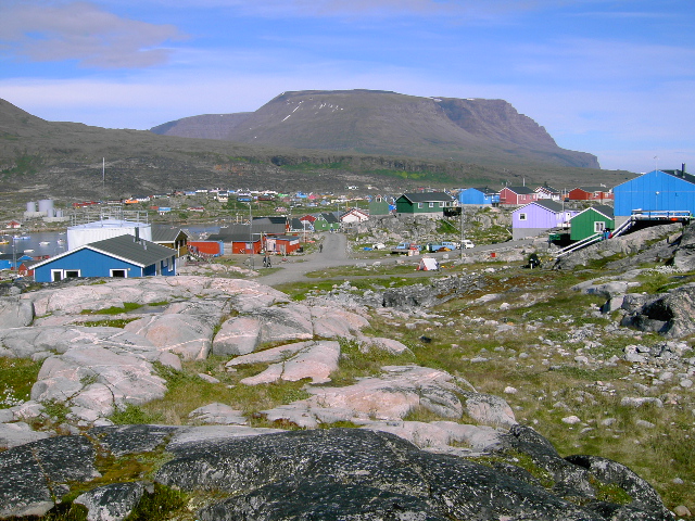
Qeqertarsuaq
Island · 8,772 km²
Qeqertarsuaq is an island in North America (Greenland), covering an estimated 8,772 km².
Disko Island (Greenlandic: Qeqertarsuaq, Danish: Diskoøen) is a large island in Baffin Bay, off the west coast of Greenland. It has an area of 8,578 km2 (3,312 mi2), making it the second largest island of Greenland (behind the main island), and one of the 100 largest islands in the world. It is part of the Qeqertalik municipality, although it lies off the coast of southern Avannaata municipality, with mainland Qeqertalik a little to the south.
Adapted from Wikipedia: Disko Island (CC BY-SA 4.0).
- Feature class
- Island
- Mapped extent
- 8,772 km²
- Size rank
- #159 of 445 islands
- Region
- North America
- Subregion
- Greenland
- Coordinates
- 69.8210°, -53.7978°
- Summits:
- Mount Odin (2,143 m), Mount Forel (3,360 m), Gunnbjørn Fjeld (3,694 m)
- Ranges:
- Grampian Mountains (Europe), Cambrian Mountains (Europe)
- Settlements:
- Reykjavík (1,499 km), Sept-Îles (2,267 km), Corner Brook (2,331 km)
More about Qeqertarsuaq
Geography
The island has a length of about 160 km (100 mi), rising to an average height of 975 m (3,199 ft), peaking at 1,919 m (6,296 ft). The port of Qeqertarsuaq (named after the island, and also known as Godhavn) lies on its southern coast. Blæsedalen valley is north of Qeqertarsuaq.
The island is separated from Nuussuaq Peninsula in the northeast by the Sullorsuaq Strait. To the south of the island lies Disko Bay, an inlet bay of Baffin Bay.
History
Research indicates that nine large tsunamigenic landslides struck Sullorsuaq Strait in prehistoric times during the Holocene, seven of them from the southern coast of the Nuussuaq Peninsula and two others from the northern coast of Disko Island. Seven of the landslides apparently occurred between about 8020 BC and 6520 BC with unidentified tsunamigenic effects. The two most recent prehistoric landslides generated megatsunamis which struck Alluttoq Island, the first sometime around 5650 BC with a run-up height of 41 to 66 metres (135 to 217 ft), and another that struck around 5350 BC with a run-up height of 45 to 70 metres (148 to 230 ft).
Erik the Red paid the first recorded visit to Disko Island at some time between 982 and 985.
Geology
Mineral deposits, fossil finds and geological formations add to interest in the area. One of the interesting geological features is the native iron found at the island. A 22-ton (44,000 lbs; 20 tonnes) lump mixture of iron and iron carbide (cohenite) has been found. There are only a few places on earth where native iron is found which is not of meteoric origin.
There are numerous hot springs on the island. The microscopic animal Limnognathia, the only known member of its phylum, was discovered in the Isunngua spring.
Sections adapted from Wikipedia: Disko Island (CC BY-SA 4.0).
Qeqertarsuaq: Key Facts
| Area | 8,612 km² |
|---|---|
| Population | 892 |
| Surrounded by | Baffin Bay |
Facts from Wikidata Q1228827 (CC0).
Mountain Ranges, Deserts and Landforms of Greenland
14 mountain ranges, deserts and other landforms recorded. Ranked by mapped area. Covers mountain ranges, deserts, plateaus, named glaciers, plains, basins, peninsulas and capes. One that crosses a border is listed under every country it lies in, with the area of the whole feature.
| # | Name | Area | Type | Region |
|---|---|---|---|---|
| 1 | North America | 27.05M km² | Continent | North America |
| 2 | Greenland Ice Sheet | 1.03M km² | Glaciated areas | — |
| 3 | Greenland Ice Sheet | 737,341 km² | Glaciated areas | — |
| 4 | Knud Rasmussen Land | 221,471 km² | Geoarea | North America |
| 5 | King Christian X Land | 29,410 km² | Geoarea | North America |
| 6 | King Frederik VIII Land | 11,805 km² | Geoarea | North America |
| 7 | King Christian IX Land | 8,932 km² | Geoarea | North America |
| 8 | Flade Isblink | 8,238 km² | Glaciated areas | — |
| 9 | King Frederik VI Coast | 2,860 km² | Coast | North America |
| 10 | King Wilhelm Land | 2,636 km² | Geoarea | North America |
States and Provinces of Greenland
2 first-level divisions with their own map.
Countries Bordering Greenland
Land and maritime neighbours.
More Maps in North America
Greenland: Quick Answers
- What is the capital of Greenland?
- The capital of Greenland is Nuuk.
- What is the population of Greenland?
- Greenland has a population of about 56,831, the #206 largest of 225 countries in YearMaps. Source: World Bank, 2025.
- How big is Greenland?
- Greenland covers 2.17M km², ranking #14 by area.
- Which continent is Greenland in?
- Greenland is in North America.
- Which countries border Greenland?
- Greenland shares a land or maritime border with Canada, Norway, Iceland.
- What is the largest city in Greenland?
- Nuuk is the largest city in Greenland, with a metropolitan population of about 14,798.
- What is the highest mountain in Greenland?
- The highest summit recorded for Greenland in YearMaps is Gunnbjørn Fjeld at 3,694 m (12,119 ft). Summits on a border are counted for both countries.