Skip to content
YearMaps
United States · Landforms

Mountain Ranges, Deserts and Landforms of United States

North America is the largest of the 62 mountain ranges, deserts and other landforms recorded for United States, at 27.05M km², ahead of Canadian Shield at 2.15M km². The full list follows.

How this list is built: Ranked by mapped area. Covers mountain ranges, deserts, plateaus, named glaciers, plains, basins, peninsulas and capes. One that crosses a border is listed under every country it lies in, with the area of the whole feature. It covers the mountain ranges, deserts and other landforms indexed in YearMaps, drawn from open geospatial data, and is not an exhaustive national register.

Landforms Listed
62
Top Ranked
27.05M km²
North America
Second
2.15M km²
Canadian Shield
Profiled Below
42
Photo, encyclopedia text and figures
Mountain Ranges, Deserts and Landforms of United States
#NameArea
1North America27.05M km²
2Canadian Shield2.15M km²
3Central Lowland2.05M km²
4Great Plains1.97M km²
5Rocky Mountains1.08M km²
6APPALACHIAN Mountains850,356 km²
7Coastal Plain625,961 km²
8Great Basin542,796 km²
9Chihuahuan Desert474,278 km²
10Alaska414,385 km²
11Colorado Plateau235,253 km²
12Sonoran Desert221,361 km²
13Coast Mountains214,489 km²
14Columbia Plat185,383 km²
15Piedmont179,956 km²
16Coast Ranges165,382 km²
17North Slope148,453 km²
18Cascade Range140,770 km²
19Alaska Range106,888 km²
20COLUMBIA Mountains93,873 km²
21Sierra Nevada69,900 km²
22Alaska Peninsula67,485 km²
23Blue Ridge60,008 km²
24Superior Upland56,025 km²
25Seward Peninsula51,397 km²
26Central Valley50,532 km²
27Ouachita Mountains48,845 km²
28Yukon Flats39,325 km²
29Kluane Ice Cap34,826 km²
30Bitterroot Range34,228 km²
31Big Bend31,974 km²
32Great Lakes31,369 km²
33Wrangell Mountains25,572 km²
34Front Range25,274 km²
35Kenai Peninsula24,588 km²
36Mogollon Rim18,745 km²
37Ogilvie Mountains15,686 km²
38Black Hills14,574 km²
39Great Salt Lake Desert10,522 km²
40Llano Estacado10,403 km²
41Stikine Icecap6,670 km²
42Juneau Icefield5,407 km²
43Edwards Plateau4,483 km²
44Sea Islands4,192 km²
45Grand Canyon3,722 km²
46Brooks Range3,380 km²
47Malaspina Glacier3,096 km²
48Harding Icefield2,525 km²
49Wasatch Range1,785 km²
50Bering Glacier1,646 km²
51Black Rock Desert1,556 km²
52Sargent Icefield1,435 km²
53Tikchik Lakes1,051 km²
54Ozark Plateau1,015 km²
55CHUGACH Mountains936 km²
56White Sands877 km²
57Finger Lakes492 km²
58Salmon River Mountains353 km²
59Klamath Mountains220 km²
60Florida119 km²
61Mississippi Delta16 km²
62Cumberland Plat—

The Landforms of United States in Detail

The 42 mountain ranges, deserts and other landforms above that have an encyclopedia article, in the same order, each with its photograph, figures and the places around it.

Rocky Mountains
Image via Wikimedia Commons (author and licence on the file page).

Rocky Mountains

Range/mtn · 1.08M km²

Rocky Mountains is a range/mtn in North America, covering an estimated 1.08M km². It extends across the United States and Canada. It is the largest of the 216 mountain ranges with a mapped extent in YearMaps.

The Rocky Mountains, also known as the Rockies, are a major mountain range and the largest mountain system in North America. The Rocky Mountains stretch 3,000 mi (4,800 km) in a straight-line distance from the northernmost part of Western Canada, to New Mexico in the Southwestern United States. Depending on differing definitions between Canada and the U.S., its northern terminus is located either in northern British Columbia's Terminal Range south of the Liard River and east of the Trench, or in the northeastern foothills of the Brooks Range/British Mountains that face the Beaufort Sea coasts between the Canning River and the Firth River across the Alaska–Yukon border. Its southernmost point is near the Albuquerque metropolitan area, adjacent to the Rio Grande rift, and north of the Sandia–Manzano Mountain Range, also near Santa Fe, New Mexico. Being the easternmost portion of the North American Cordillera, the Rockies are distinct from the tectonically younger Cascade Range and Sierra Nevada, which both lie farther to its west.

Adapted from Wikipedia: Rocky Mountains (CC BY-SA 4.0).

Feature class
Range/mtn
Mapped extent
1.08M km²
Size rank
#1 of 216 mountain ranges
Region
North America
Countries
United States, Canada
Coordinates
42.2572°, -108.8156°
Summits:
Gannett Peak (4,207 m), Grand Teton (4,199 m), Crazy Peak (3,417 m)
Adjacent ranges:
Wasatch Range (North America), Black Hills (North America)
Settlements:
Logan (174 km), Idaho Falls (198 km), Pocatello (205 km)

View on the live map

More about Rocky Mountains

Geography

The Rocky Mountains are the easternmost portion of the expansive North American Cordillera. They are often defined as a network stretching from the Liard River in British Columbia south to the headwaters of the Pecos River, a tributary of the Rio Grande, in New Mexico. The Rockies vary in width from 110 to 480 kilometers (70 to 300 miles). The greater Rocky Mountain system functions as a collective network of dozens of distinct subranges divided by high basins and wide rolling tablelands. The Rocky Mountains contain the highest peaks in central North America. The range's highest peak is Mount Elbert in Colorado at 4,401 meters (14,440 feet) above sea level. Mount Robson in British Columbia, at 3,954 m (12,972 ft), is the highest peak in the Canadian Rockies.

Geology

The rocks in the Rocky Mountains were formed before the mountains were raised by tectonic forces. The oldest rock is Precambrian metamorphic rock that forms the core of the North American continent. There is also Precambrian sedimentary argillite, dating back to 1.7 billion years ago. During the Paleozoic, western North America lay underneath a shallow sea, which deposited many kilometers of limestone and dolomite.

In the southern Rockies, near present-day Colorado, these ancestral rocks were disturbed by mountain building approximately 300 million years ago, during the Pennsylvanian. This mountain-building produced the Ancestral Rocky Mountains. They consisted largely of Precambrian metamorphic rock forced upward through layers of the limestone laid down in the shallow sea.

Ecology and climate

There are a wide range of environmental factors in the Rocky Mountains. The Rockies range in latitude between the Liard River in British Columbia (at 59° N) and the Rio Grande in New Mexico (at 35° N). Prairie occurs at or below 550 meters (1,800 ft), while the highest peak in the range is Mount Elbert at 4,400 meters (14,440 ft). Precipitation ranges from 250 millimeters (10 in) per year in the southern valleys to 1,500 millimeters (60 in) per year locally in the northern peaks. Average January temperatures can range from −7 °C (20 °F) in Prince George, British Columbia, to 6 °C (43 °F) in Trinidad, Colorado. Therefore, there is no single monolithic ecosystem for the entire Rocky Mountain Range.

Instead, ecologists divide the Rockies into a number of biotic zones.

History

Since the last great ice age, the Rocky Mountains were home first to indigenous peoples including the Apache, Arapaho, Bannock, Blackfoot, Cheyenne, Coeur d'Alene, Kalispel, Crow Nation, Flathead, Shoshone, Sioux, Ute, Kutenai (Ktunaxa in Canada), Sekani, Dunne-za, and others. Paleo-Indians hunted the now-extinct mammoth and ancient bison (an animal 20% larger than modern bison) in the foothills and valleys of the mountains.

Sections adapted from Wikipedia: Rocky Mountains (CC BY-SA 4.0).

Rocky Mountains: Key Facts

Key facts about Rocky Mountains
Length3,000 km
Highest pointMount Elbert
Part ofNorth American Cordillera

Facts from Wikidata Q5463 (CC0).

Coastal Plain
Image via Wikimedia Commons (author and licence on the file page).

Coastal Plain

Plain · 625,961 km²

Coastal Plain is a plain in North America, covering an estimated 625,961 km². It is the 24th-largest of the 231 landforms with a mapped extent in YearMaps.

A coastal plain (also coastal plains, coastal lowland, coastal lowlands) is an area of flat, low-lying land adjacent to a sea coast. A fall line commonly marks the border between a coastal plain and an upland area.

Adapted from Wikipedia: Coastal plain (CC BY-SA 4.0).

Feature class
Plain
Mapped extent
625,961 km²
Size rank
#24 of 231 landforms
Region
North America
Coordinates
31.1538°, -83.0992°
Summits:
Clingmans Dome (2,025 m), Mount Mitchell (2,037 m), Mount Rogers (1,746 m)
Ranges:
Blue Ridge (North America), Ouachita Mountains (North America)
Settlements:
Valdosta (40 km), Albany (111 km), Lake City (116 km)

View on the live map

Great Basin
Image via Wikimedia Commons (author and licence on the file page).

Great Basin

Basin · 542,796 km²

Great Basin is a basin in North America, covering an estimated 542,796 km². It is the 25th-largest of the 231 landforms with a mapped extent in YearMaps.

The Great Basin (Spanish: Gran Cuenca) is the largest area of contiguous endorheic watersheds, those with no outlets to the ocean, in North America. It spans nearly all of Nevada, much of Utah, and portions of California, Idaho, Oregon, Wyoming, and Baja California. It is noted for both its arid climate and the basin and range topography that varies from the North American low point at Badwater Basin in Death Valley to the highest point of the contiguous United States, less than 100 miles (160 km) away at the summit of Mount Whitney. The region spans several physiographic divisions, biomes, ecoregions, and deserts.

Adapted from Wikipedia: Great Basin (CC BY-SA 4.0).

Feature class
Basin
Mapped extent
542,796 km²
Size rank
#25 of 231 landforms
Region
North America
Coordinates
39.4307°, -116.5550°
Summits:
White Mountain Peak (4,342 m), Mount Whitney (4,421 m), Mount Shasta (4,322 m)
Ranges:
Sierra Nevada (North America), Wasatch Range (North America)
Settlements:
Carson City (278 km), Reno (280 km), Cedar City (361 km)

View on the live map

More about Great Basin

Geography

The Great Basin physiographic section of the Basin and Range Province contains the Great Basin, but extends into eastern Oregon, southern Idaho, and the Colorado River watershed and the northwest corner of Arizona. The Basin and Range region is the product of geological forces stretching the Earth's crust, creating many north–south trending mountain ranges. These ranges are separated by flat valleys or basins. These hundreds of ranges make Nevada the most mountainous state in the country.

The Great Basin's two most populous metropolitan areas are the Reno-Sparks metropolitan area to the west and the Salt Lake City centered Wasatch Front to the east (with the latter being significantly more populous than the former).

Geology

The Great Basin includes valleys, basins, lakes and mountain ranges of the Basin and Range Province.

The basin and range topography is the result of extension and thinning of the lithosphere, which is composed of crust and upper mantle. Extensional environments like the Basin and Range are characterized by listric normal faulting, or faults that level out with depth. Opposing normal faults link at depth producing a horst and graben geometry, where horst refers to the upthrown fault block and graben to the down dropped fault block.

Sediment build-up over thousands of years filled the down-faulted basins between ranges and created relatively flat lacustrine plains from Pleistocene lake beds of the Great Basin.

Climate

The climate varies throughout the Great Basin by elevation, latitude, and other factors. Higher elevations tend to be cooler and receive more precipitation. The western areas of the basin tend to be drier than the eastern areas because of the rain shadow of the Sierra Nevada. Most of the basin experiences a semi-arid or arid climate with warm summers and cold winters. However, some of the mountainous areas in the basin are high enough in elevation to experience an alpine climate. Due to the region's altitude and aridity, most areas in the Great Basin experience a substantial diurnal temperature variation.

Ecology

The hydrographic Great Basin contains multiple deserts and ecoregions, each with its own distinctive set of flora and fauna. The ecological boundaries and divisions in the Great Basin are unclear.

The Great Basin overlaps four different deserts: portions of the hot Mojave and Colorado (a region within the Sonoran Desert) Deserts to the south, and the cold Great Basin and Oregon High Deserts in the north. The deserts can be distinguished by their plants: the Joshua tree and creosote bush occur in the hot deserts, while the cold deserts have neither. The cold deserts are generally higher than the hot and have more even spread of precipitation throughout the year.

Sections adapted from Wikipedia: Great Basin (CC BY-SA 4.0).

Great Basin: Key Facts

Key facts about Great Basin
Highest pointMount Whitney

Facts from Wikidata Q966943 (CC0).

Chihuahuan Desert
Image via Wikimedia Commons (author and licence on the file page).

Chihuahuan Desert

Desert · 474,278 km²

Chihuahuan Desert is a desert in North America, covering an estimated 474,278 km². It extends across Mexico and the United States. It is the 5th-largest of the 58 deserts with a mapped extent in YearMaps.

The Chihuahuan Desert (Spanish: Desierto de Chihuahua, Desierto Chihuahuense) is a desert ecoregion designation covering parts of northern Mexico and the southwestern United States. It occupies much of Far West Texas, the middle to lower Rio Grande Valley and the lower Pecos Valley in New Mexico, and a portion of southeastern Arizona, as well as the central and northern portions of the Mexican Plateau. It is bordered on the west by the Sonoran Desert, the Colorado Plateau, and the extensive Sierra Madre Occidental range, along with the northwestern lowlands of the Sierra Madre Oriental range. Its largest, continual expanse is located in Mexico, covering a large portion of the state of Chihuahua, along with portions of Coahuila, north-eastern Durango, the extreme northern part of Zacatecas, and small western portions of Nuevo León. With an area of about 501,896 km2 (193,783 sq mi), it is the largest hot desert in North America. The desert is fairly young, existing for only 8,000 years.

Adapted from Wikipedia: Chihuahuan Desert (CC BY-SA 4.0).

Feature class
Desert
Mapped extent
474,278 km²
Size rank
#5 of 58 deserts
Region
North America
Countries
Mexico, United States
Coordinates
27.2192°, -103.7755°
Summits:
Sierra Blanca Peak (3,649 m), Fishers Peak (2,934 m), Mount Peale (3,877 m)
Ranges:
Sierra Madre Occidental (North America), Mogollon Rim (North America)
Settlements:
Las Cruces (22 km), El Paso (42 km), Alamogordo (109 km)

View on the live map

More about Chihuahuan Desert

Geography

There are several larger mountain ranges in the Chihuahuan Desert, including the Sierra Madre, the Sierra del Carmen, the Organ Mountains, the Franklin Mountains, the Sacramento Mountains, the Chisos Mountains, the Guadalupe Mountains, and the Davis Mountains. These create "sky islands" of cooler, wetter, climates adjacent to, or within the desert, and such elevated areas have both coniferous and broadleaf woodlands, including forests along drainages and favored exposures. The lower elevations of the Sandia–Manzano Mountains, the Magdalena–San Mateo Mountains, and the Gila Region partly border the Chihuahuan Desert and partly border other ecoregions that are not deserts.

Climate

The desert is mainly a rain shadow desert because the two main mountain ranges which bound the desert, the Sierra Madre Occidental to the west and the Sierra Madre Oriental to the east, block most moisture from the Pacific Ocean and the Gulf of Mexico, respectively. Climatically, the desert mostly has an arid, mesothermal climate with one rainy season in the late summer and smaller amounts of precipitation in early winter, the mean daily temperature of the coldest month warmer than 0 °C (32 °F). The majority of rain falls between late June and early October during the North American Monsoon, when moist air from the Gulf of Mexico and the Sea of Cortez penetrates into the region, or much less frequently, when a tropical cyclone moves inland and stalls.

Sections adapted from Wikipedia: Chihuahuan Desert (CC BY-SA 4.0).

Chihuahuan Desert: Key Facts

Key facts about Chihuahuan Desert
Area362,600 km²

Facts from Wikidata Q855658 (CC0).

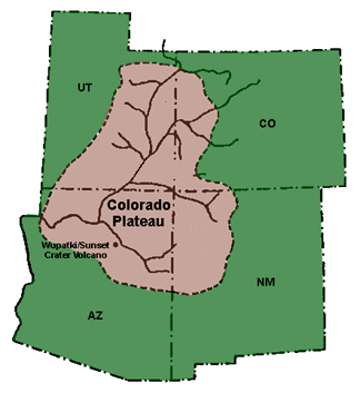
Colorado Plateau
Image via Wikimedia Commons (author and licence on the file page).

Colorado Plateau

Plateau · 235,253 km²

Colorado Plateau is a plateau in North America, covering an estimated 235,253 km². It is the 16th-largest of the 69 plateaus with a mapped extent in YearMaps.

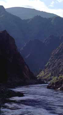
The Colorado Plateau is a physiographic and desert region of the Intermontane Plateaus, roughly centered on the Four Corners region of the Southwestern United States. It covers an area of 130,000 sq mi (340,000 km2) within western Colorado, northwestern New Mexico, southern and eastern Utah, northern Arizona, and a small region in the extreme southeast of Nevada. About 90% of the area is drained by the Colorado River and its main tributaries: the Green, San Juan, and Little Colorado. Most of the remainder of the plateau is drained by the Rio Grande and its tributaries.

The Colorado Plateau is largely made up of high desert, with scattered areas of forests. In the south-west corner of the Colorado Plateau, nicknamed High Country, lies the Grand Canyon of the Colorado River. Much of the Plateau's landscape is related to the Grand Canyon in both appearance and geologic history. The nickname "Red Rock Country" suggests the brightly colored rock left bare to the view by dryness and erosion. Domes, hoodoos, fins, reefs, river narrows, natural bridges, and slot canyons are only some of the additional features typical of the Plateau.

Adapted from Wikipedia: Colorado Plateau (CC BY-SA 4.0).

Feature class
Plateau
Mapped extent
235,253 km²
Size rank
#16 of 69 plateaus
Region
North America
Coordinates
36.6930°, -110.2468°
Summits:
Mount Peale (3,877 m), Mount Elbert (4,402 m), Fishers Peak (2,934 m)
Ranges:
Mogollon Rim (North America), Wasatch Range (North America)
Settlements:
Farmington (184 km), Gallup (188 km), Flagstaff (209 km)

View on the live map

More about Colorado Plateau

Geography

This province is bounded by the Rocky Mountains in Colorado and by the Uinta Mountains and Wasatch Mountains branches of the Rockies in northern and central Utah. It is also bounded by the Rio Grande rift, Mogollon Rim, and the Basin and Range Province (at the Hurricane Fault). Isolated ranges of the Southern Rocky Mountains, such as the San Juan Mountains in Colorado and the La Sal Mountains in Utah, intermix into the central and southern parts of the Colorado Plateau.

As the name implies, the High Plateaus Section is, on average, the highest section. North-south trending normal faults that include the Hurricane, Sevier, Grand Wash, and Paunsaugunt separate the section's component plateaus.

Geology

One of the most geologically intriguing features of the Colorado Plateau is its remarkable stability. Relatively little rock deformation such as faulting and folding has affected this high, thick crustal block within the last 600 million years or so, although there are some newer features such as the Waterpocket Fold of Capitol Reef (estimated 50–70 million years old). In contrast, provinces that have suffered severe deformation surround the plateau. Mountain building thrust up the Rocky Mountains to the north and east and tremendous, earth-stretching tension produced the Basin and Range Province to the west and south. Sub ranges of the Southern Rocky Mountains are scattered throughout the Colorado Plateau.

Human history

The Ancestral Puebloan People lived in the region from roughly 2000 to 700 years ago. A party from Santa Fe led by Fathers Dominguez and Escalante, unsuccessfully seeking an overland route to California, made a five-month out-and-back trip through much of the Plateau in 1776–1777. Despite having lost one arm in the American Civil War, U.S. Army Major and geologist John Wesley Powell explored the area in 1869 and 1872. Using wooden oak boats and small groups of men, the Powell Geographic Expedition charted this largely unknown region of the United States for the federal government.

Construction of the Hoover Dam in the 1930s and the Glen Canyon Dam in the 1960s changed the character of the Colorado River.

Sections adapted from Wikipedia: Colorado Plateau (CC BY-SA 4.0).

Sonoran Desert
Image via Wikimedia Commons (author and licence on the file page).

Sonoran Desert

Desert · 221,361 km²

Sonoran Desert is a desert in North America, covering an estimated 221,361 km². It extends across the United States and Mexico. It is the 9th-largest of the 58 deserts with a mapped extent in YearMaps.

The Sonoran Desert (Spanish: Desierto de Sonora) is a hot desert and ecoregion in North America that covers parts of the northwestern Mexican states of Sonora, Baja California, and Baja California Sur, as well as part of the Southwestern United States (in Arizona and California). It has an area of 260,000 square kilometers (100,000 sq mi).

In phytogeography, the Sonoran Desert is within the Sonoran floristic province of the Madrean region of southwestern North America, part of the Holarctic realm of the northern Western Hemisphere. The desert contains a variety of unique endemic plants and animals, notably, the saguaro (Carnegiea gigantea) and organ pipe cactus (Stenocereus thurberi).

The Sonoran Desert is clearly distinct from nearby deserts (e.g., the Great Basin, Mojave, and Chihuahuan deserts) because it provides subtropical warmth in winter and two seasons of rainfall (in contrast, for example, to the Mojave's dry summers and cold winters). This creates an extreme contrast between aridity and moisture.

It is asserted (though possible contrary evidence exists) that the Sonoran is the joint hottest desert on Earth.

Adapted from Wikipedia: Sonoran Desert (CC BY-SA 4.0).

Feature class
Desert
Mapped extent
221,361 km²
Size rank
#9 of 58 deserts
Region
North America
Countries
United States, Mexico
Coordinates
32.8231°, -113.0445°
Summits:
Mount Whitney (4,421 m), White Mountain Peak (4,342 m), Sierra Blanca Peak (3,649 m)
Ranges:
Mogollon Rim (North America), Sierra Madre Occidental (North America)
Settlements:
Glendale (115 km), Phoenix (123 km), Yuma (133 km)

View on the live map

More about Sonoran Desert

Climate

The Sonoran desert has an arid subtropical climate and is considered to be the most tropical desert in North America. In the lower-elevation portions of the desert, temperatures are warm year-round, and rainfall is infrequent and irregular, often less than 90 mm (approx. 3.5") annually. The Arizona uplands are also warm year-round, but they receive 100–300 mm (approx. 4–12") of average annual rainfall, which falls in a more regular bi-seasonal pattern.

According to the Köppen climate classification system, the majority of the Sonoran Desert has a hot desert climate (BWh).

Location

The Sonoran desert wraps around the northern end of the Gulf of California, from Baja California Sur (El Vizcaíno Biosphere Reserve in central and Pacific west coast, Central Gulf Coast subregion on east to southern tip), north through much of Baja California, excluding the central northwest mountains and Pacific west coast, through southeastern California and southwestern and southern Arizona to western and central parts of Sonora.

It is bounded on the west by the Peninsular Ranges, which separate it from the California chaparral and woodlands (northwest) and Baja California desert (Vizcaíno subregion, central and southeast) ecoregions of the Pacific slope.

Sections adapted from Wikipedia: Sonoran Desert (CC BY-SA 4.0).

Sonoran Desert: Key Facts

Key facts about Sonoran Desert
Area310,800 km²

Facts from Wikidata Q189429 (CC0).

Coast Mountains
Image via Wikimedia Commons (author and licence on the file page).

Coast Mountains

Range/mtn · 214,489 km²

Coast Mountains is a range/mtn in North America, covering an estimated 214,489 km². It extends across Canada and the United States. It is the 16th-largest of the 216 mountain ranges with a mapped extent in YearMaps.

The Coast Mountain(s) (French: La chaîne Côtière) is a major mountain range in the Pacific Coast Ranges of western North America, extending from southwestern Yukon through the Alaska Panhandle and virtually all of the Coast of British Columbia south to the Fraser River. The mountain range's name derives from its proximity to the sea coast, and it is often referred to as the Coast Range. The range includes volcanic and non-volcanic mountains and the extensive ice fields of the Pacific and Boundary Ranges, and the northern end of the volcanic system known as the Cascade Volcanoes. The Coast Mountains are part of a larger mountain system called the Pacific Coast Ranges or the Pacific Mountain System, which includes the Cascade Range, the Insular Mountains, the Olympic Mountains, the Oregon Coast Range, the California Coast Ranges, the Saint Elias Mountains and the Chugach Mountains. The Coast Mountains are also part of the American Cordillera—a Spanish term for an extensive chain of mountain ranges—that consists of an almost continuous sequence of mountain ranges that form the western backbone of North America, Central America, South America and Antarctica.

Adapted from Wikipedia: Coast Mountains (CC BY-SA 4.0).

Feature class
Range/mtn
Mapped extent
214,489 km²
Size rank
#16 of 216 mountain ranges
Region
North America
Countries
Canada, United States
Coordinates
50.2747°, -123.0477°
Summits:
Devils Paw (2,593 m), Chilkoot Pass (1,067 m), Mount Fairweather (4,671 m)
Adjacent ranges:
Cassiar Mountains (North America), Wrangell Mountains (North America)
Settlements:
Juneau (165 km), Anchorage (1,078 km), Bellingham (1,154 km)

View on the live map

More about Coast Mountains

Geography

The Coast Mountains consists of three subdivisions known as the Pacific Ranges, the Kitimat Ranges, and the Boundary Ranges. The Pacific Ranges are the southernmost subdivision of the Coast Mountains, extending from the lower stretches of the Fraser River to Bella Coola. Included in this subdivision are four of the five major coastal icecaps in the southern Coast Mountains. These are the largest temperate-latitude icecaps in the world and fuel a number of major rivers. Other than logging and a large ski resort at the resort town of Whistler, most of the land in the range is completely undeveloped. Mount Waddington, the highest mountain of the Coast Mountains, lies in the Waddington Range of the Pacific Ranges.

Geology

The Coast Mountains consist of deformed igneous and metamorphosed structurally complex pre-Tertiary rocks. These originated in diverse locations around the globe: the area is built of several different terranes of different ages with a broad range of tectonic origins. In addition, oceanic crust under the Pacific Ocean is being subducted at the southern portion of the range to form a north–south line of volcanoes called the Garibaldi Volcanic Belt, a northern extension of the Cascade Volcanoes in the northwestern United States, and contains the most explosive young volcanoes in Canada. Further north the northwesterly structural trend of the Coast Mountains lies partly in a large continental rift responsible for the creation of several volcanoes.

Sections adapted from Wikipedia: Coast Mountains (CC BY-SA 4.0).

Coast Mountains: Key Facts

Key facts about Coast Mountains
Length1,600 km
Area336,962 km²
Highest pointMount Waddington
Part ofPacific Coast Ranges

Facts from Wikidata Q920070 (CC0).

Cascade Range
Image via Wikimedia Commons (author and licence on the file page).

Cascade Range

Range/mtn · 140,770 km²

Cascade Range is a range/mtn in North America, covering an estimated 140,770 km². It extends across the United States and Canada.

The Cascade Range, or Cascades, is a major mountain range of western North America, extending from southern British Columbia through Washington and Oregon to Northern California. It includes both non-volcanic mountains, such as many of those in the North Cascades, and the notable volcanoes known as the High Cascades. The small part of the range in British Columbia is referred to as the Canadian Cascades or, locally, as the Cascade Mountains. The highest peak in the range is Mount Rainier in Washington at 14,411 feet (4,392 m).

The Cascades are part of the Pacific Ocean's Ring of Fire, the ring of volcanoes and associated mountains around the Pacific Ocean. All of the eruptions in the contiguous United States over the last 200 years have been from the Cascade Volcanoes. The two most recent were Lassen Peak from 1914 to 1921 and a major eruption of Mount St. Helens in 1980. Minor eruptions of Mount St. Helens have also occurred since, most recently from 2004 to 2008. The Cascade Range is a part of the American Cordillera, a nearly continuous chain of mountain ranges (cordillera) that form the western "backbone" of North, Central, and South America.

Adapted from Wikipedia: Cascade Range (CC BY-SA 4.0).

Feature class
Range/mtn
Mapped extent
140,770 km²
Size rank
#30 of 216 mountain ranges
Region
North America
Countries
United States, Canada
Coordinates
48.5429°, -120.9709°
Summits:
Mount Hood (3,426 m), Mount Rainier (4,392 m), Mount Baker (3,286 m)
Adjacent ranges:
Klamath Mountains (North America), Salmon River Mountains (North America)
Settlements:
Vancouver (81 km), Portland (82 km), Salem (123 km)

View on the live map

More about Cascade Range

Geography

The Cascades extend northward from Lassen Peak (also known as Mount Lassen) in northern California to the confluence of the Nicola and Thompson rivers in British Columbia. The Fraser River separates the Cascades from the Coast Mountains in Canada, as does the Willamette Valley from the upper portion of the Oregon Coast Range. The highest volcanoes of the Cascades, known as the High Cascades, dominate their surroundings, often standing twice the height of the nearby mountains. They often have a visual height (height above nearby crestlines) of one mile or more. The highest peaks, such as the 14,411-foot (4,392 m) Mount Rainier, dominate their surroundings for 50 to 100 miles (80 to 161 km).

Geology

The Cascade Range is made up of a band of thousands of very small, short-lived volcanoes that have built a platform of lava and volcanic debris. Rising above this volcanic platform are a few strikingly large volcanoes, like Mount Hood and Mount St. Helens, that dominate the landscape.

The Cascade volcanoes define the Pacific Northwest section of the Ring of Fire, an array of volcanoes that rim the Pacific Ocean. The Ring of Fire is also known for its frequent earthquakes. The volcanoes and earthquakes arise from a common source, namely subduction. In this case, the dense Juan de Fuca Plate plunges beneath the North American Plate at the Cascadia subduction zone.

Ecology

Forests of large, coniferous trees (western red cedars, Douglas-firs, western hemlocks, firs, pines, spruces, and others) dominate most of the Cascade Range. Cool, wet winters and warm, dry summers (largely a result of oceanic influence) favor evergreen species, whereas mild temperatures and rich soils promote fast and prolonged growth.

As a traveler passes through the Cascade Range, the climate first gets colder, then warmer and drier east of the crest. Most of the Cascades' lower and middle elevations are covered in coniferous forest; the higher altitudes have extensive meadows as well as alpine tundra and glaciers. The southern part of the Cascades are within the California Floristic Province, an area of high biodiversity.

History

Before European exploration, First Nations tribes named many peaks, including "Seekseekqua" for Mount Jefferson (Oregon), "M'laiksini Yaina" for Mount McLoughlin, "Tahoma", the Lushootseed name for Mount Rainier, and "Louwala-Clough", meaning "smoking mountain" for Mount St. Helens.

In early 1792, British navigator George Vancouver explored Puget Sound and gave English names to the high mountains he saw. Mount Baker was named for Vancouver's third lieutenant, Joseph Baker, although the first European to see it was Manuel Quimper, who named it la gran montaña del Carmelo ("Great Mount Carmel") in 1790. Mount Rainier was named after Admiral Peter Rainier.

Sections adapted from Wikipedia: Cascade Range (CC BY-SA 4.0).

Cascade Range: Key Facts

Key facts about Cascade Range
Length1,100 km
Area150,000 km²
Highest pointMount Rainier
Part ofPacific Coast Ranges

Facts from Wikidata Q4558 (CC0).

Alaska Range
Image via Wikimedia Commons (author and licence on the file page).

Alaska Range

Range/mtn · 106,888 km²

Alaska Range is a range/mtn in North America, covering an estimated 106,888 km².

The Alaska Range is a relatively narrow, 600-mile-long (970-kilometer) mountain range in the southcentral region of the U.S. state of Alaska, from Lake Clark at its southwest end to the White River in Canada's Yukon Territory in the southeast. Denali, the highest mountain in North America, is in the Alaska Range. The range is part of the American Cordillera.

The Alaska Range is one of the highest mountain ranges in the world, after the Himalayas and the Andes.

Adapted from Wikipedia: Alaska Range (CC BY-SA 4.0).

Feature class
Range/mtn
Mapped extent
106,888 km²
Size rank
#39 of 216 mountain ranges
Region
North America
Coordinates
62.1525°, -151.9879°
Summits:
Denali (6,194 m), Redoubt Volcano (3,108 m), Mount Blackburn (4,996 m)
Adjacent ranges:
Wrangell Mountains (North America), Ogilvie Mountains (North America)
Settlements:
Anchorage (151 km), Fairbanks (366 km), Whitehorse (912 km)

View on the live map

More about Alaska Range

History

The name "Alaskan Range" appears to have been first applied to these mountains in 1869 by naturalist W. H. Dall. The name eventually became "Alaska Range" through local use. In 1849 Constantin Grewingk applied the name "Tschigmit" to this mountain range. A map made by the United States General Land Office in 1869 calls the southwestern part of the Alaska Range the "Chigmit Mountains" and the northeastern part the "Beaver Mountains". However, the Chigmit Mountains are now considered part of the Aleutian Range.

Starting in the mid-1880s to early 1900s, early non-native explorers traversed various sections of the Alaska Range. The first recorded expedition was in the Eastern Alaska Range led by H. T. Allen in 1885.

Description

The range forms a generally east–west arc with its northernmost part in the center, and from there trending southwest towards the Alaska Peninsula and the Aleutian Islands, and trending southeast into British Columbia and the Pacific Coast Ranges. The mountains act as a high barrier to the flow of moist air from the Gulf of Alaska northwards, and thus have some of the harshest weather in the world. The heavy snowfall also contributes to a number of large glaciers, including the Cantwell, Castner, Black Rapids, Susitna, Yanert, Muldrow, Eldridge, Ruth, Tokositna, and Kahiltna Glaciers. Four major rivers cross the Alaska Range, including the Delta and Nenana Rivers in the center of the range and the Nabesna and Chisana Rivers to the east.

Sections adapted from Wikipedia: Alaska Range (CC BY-SA 4.0).

Alaska Range: Key Facts

Key facts about Alaska Range
Length1,000 km
Area144,752 km²
Part ofNorth American Cordillera

Facts from Wikidata Q156684 (CC0).

Sierra Nevada
Image via Wikimedia Commons (author and licence on the file page).

Sierra Nevada

Range/mtn · 69,900 km²

Sierra Nevada is a range/mtn in North America, covering an estimated 69,900 km².

The Sierra Nevada ( see-ERR-ə nih-VA(H)D-ə) is a mountain range in the Western United States, between the Central Valley of California and the Great Basin. The vast majority of the range lies in the state of California, although the Carson Range spur lies primarily in Nevada. The Sierra Nevada is part of the American Cordillera, an almost continuous chain of mountain ranges that forms the western "backbone" of the Americas.

The Sierra runs 400 mi (640 km) north-south, and its width ranges from 50 mi (80 km) to 80 mi (130 km) across east–west. Notable features include the General Sherman Tree, the largest tree in the world by volume; Lake Tahoe, the largest alpine lake in North America; Mount Whitney at 14,505 ft (4,421 m), the highest point in the contiguous United States; and Yosemite Valley sculpted by glaciers from one-hundred-million-year-old granite, containing high waterfalls. The Sierra is home to three national parks, twenty-six wilderness areas, ten national forests, and two national monuments. These areas include Yosemite, Sequoia, and Kings Canyon National Parks, as well as Devils Postpile National Monument.

Adapted from Wikipedia: Sierra Nevada (CC BY-SA 4.0).

Feature class
Range/mtn
Mapped extent
69,900 km²
Size rank
#55 of 216 mountain ranges
Region
North America
Coordinates
38.2153°, -120.0402°
Summits:
White Mountain Peak (4,342 m), Mount Whitney (4,421 m), Mount Shasta (4,322 m)
Adjacent ranges:
Klamath Mountains (North America), Wasatch Range (North America)
Settlements:
Modesto (104 km), Carson City (108 km), Merced (109 km)

View on the live map

More about Sierra Nevada

Geography

The Sierra Nevada lies primarily in Central and Eastern California, with the Carson Range, a small but historically important spur, extending into Nevada. West-to-east, the Sierra Nevada's elevation increases gradually from 500 feet (150 m) in the Central Valley to more than 14,000 feet (4,300 m) atop the highest peaks of its crest 50 to 75 miles (80 to 121 km) to the east. The east slope forms the steep Sierra Escarpment. Unlike its surroundings, the range receives a substantial amount of snowfall and precipitation due to orographic lift.

The Sierra Nevada's irregular northern boundary stretches from the Susan River and Fredonyer Pass to the North Fork Feather River.

Climate and meteorology

The climate of the Sierra Nevada is influenced by the Mediterranean climate of California. During the fall, winter and spring, precipitation in the Sierra ranges from 20 to 80 in (510 to 2,030 mm) where it occurs mostly as snow above 6,000 ft (1,800 m). Precipitation is highest on the central and northern portions of the western slope between 5,000 and 8,000 feet (1,500 and 2,400 m) elevation, due to orographic lift. Above 8,000 feet (2,400 m), precipitation diminishes on the western slope up to the crest, since most of the precipitation has been wrung out at lower elevations. Most parts of the range east of the crest are in a rain shadow, and receive less than 25 inches of precipitation per year.

Ecology

The western foothill zone, 1,000–2,500 ft (300–760 m), with grassland, oak-grass savanna and chaparral-oak woodland. Gray pine (also known as Foothill pine) is intermixed with the oak woodland.

The Pinyon pine-Juniper woodland, 5,000–7,000 ft (1,500–2,100 m) east side only.

The Sierra Nevada lower montane forest (indicator species: Ponderosa pine, Jeffrey pine), 2,500–7,000 ft (760–2,130 m) west side, 7,000–9,000 ft (2,100–2,700 m) east side. This biotic zone is notable for containing giant sequoia.

The Sierra Nevada upper montane forest (indicator species: Lodgepole pine, Red fir) 7,000–9,000 ft (2,100–2,700 m) west side, 9,000–10,500 ft (2,700–3,200 m) east side.

The alpine region at greater than 10,500 ft (3,200 m), and greater than 11,500 ft (3,500 m) east side.

History

Archaeological excavations placed Martis people of Paleo-Indians in northcentral Sierra Nevada during the period of 3,000 BCE to 500 CE. The earliest identified sustaining indigenous people in the Sierra Nevada were the Northern Paiute tribes on the east side, with the Mono tribe and Sierra Miwok tribe on the western side, and the Kawaiisu and Tübatulabal tribes in the southern Sierra. Today, some historic intertribal trade route trails over mountain passes are known artifact locations, such as Duck Pass with its obsidian arrowheads.

Sections adapted from Wikipedia: Sierra Nevada (CC BY-SA 4.0).

Sierra Nevada: Key Facts

Key facts about Sierra Nevada
Length644 km
Area63,118 km²
Highest pointMount Whitney
Part ofNorth American Cordillera

Facts from Wikidata Q26777 (CC0).

Alaska Peninsula
Image via Wikimedia Commons (author and licence on the file page).

Alaska Peninsula

Pen/cape · 67,485 km²

Alaska Peninsula is a pen/cape in North America, covering an estimated 67,485 km².

The Alaska Peninsula (also called the Aleut Peninsula or the Aleutian Peninsula, Aleut: Alaxsxix̂; Sugpiaq: Aluuwiq, Al'uwiq) extends about 497 mi (800 km) to the southwest from the mainland of Alaska and ending in the Aleutian Islands. The peninsula separates the Pacific Ocean from Bristol Bay, an arm of the Bering Sea.

In literature (especially Russian), the term Alaska Peninsula was used to denote the entire north-western protrusion of the North American continent, or all of what is now the state of Alaska, exclusive of its panhandle and islands. The Lake and Peninsula borough, the Alaskan equivalent of a county, is named after the peninsula.

The Alaska/Aleutian Peninsula is also grouped into Southwest Alaska.

The other large peninsulas in Alaska include the Kenai Peninsula and the Seward Peninsula.

Adapted from Wikipedia: Alaska Peninsula (CC BY-SA 4.0).

Feature class
Pen/cape
Mapped extent
67,485 km²
Size rank
#75 of 231 landforms
Region
North America
Coordinates
58.5662°, -155.7150°
Summits:
Mount Katmai (2,047 m), Redoubt Volcano (3,108 m), Denali (6,194 m)
Ranges:
Alaska Range (North America), Wrangell Mountains (North America)
Settlements:
Anchorage (438 km), Fairbanks (814 km), Whitehorse (1,180 km)

View on the live map

More about Alaska Peninsula

Geography

The base of the Alaska Peninsula extends outward from the end of the Alaska Range.

The Aleutian Range is a very active volcanic mountain range which runs along the entire length of the peninsula. Within it lie Wildlife Refuges, including the Katmai National Park and Preserve, the Aniakchak National Monument and Preserve and the Becharof National Wildlife Refuge, the Alaska Peninsula National Wildlife Refuge, and the Izembek National Wildlife Refuge. The most active volcano along the volcanic mountain range is Pavlof Volcano which is more than 8,251 feet (2,515 meters)(see also: Aleutian Arc).

Climate

Average annual precipitation ranges from 24–65 in (610–1,650 mm). Coastal areas are subject to intense storms, wind, and rain. Winter temperatures average between 12 and 34 °F (−11 and 1 °C), and in summer between 43 and 59 °F (6 and 15 °C). Frosts can occur any day of the year at higher elevations. The climate can be compared to that of parts of Scotland, the Aleutian Islands, Iceland, and Tierra del Fuego.

Sections adapted from Wikipedia: Alaska Peninsula (CC BY-SA 4.0).

Alaska Peninsula: Key Facts

Key facts about Alaska Peninsula
Area1,500,000 km²
OnBering Sea

Facts from Wikidata Q60064 (CC0).

Blue Ridge
Image via Wikimedia Commons (author and licence on the file page).

Blue Ridge

Range/mtn · 60,008 km²

Blue Ridge is a range/mtn in North America, covering an estimated 60,008 km².

The Blue Ridge Mountains (Cherokee: ᏌᎪᏂᎨ ᏣᎴᎩ, Sagonige Tsalegi, "blue mountain ridge") are a physiographic province of the larger Appalachian Highlands range. The mountain range is located in the Eastern United States and extends 550 miles (885 km) southwest from southern Pennsylvania through Maryland, West Virginia, Virginia, North Carolina, South Carolina, Tennessee, and Georgia. The province consists of northern and southern physiographic regions, which divide near the Roanoke River gap. To the west of the Blue Ridge, between it and the bulk of the Appalachians, lies the Great Appalachian Valley, bordered on the west by the Ridge and Valley province of the Appalachian range.

The Blue Ridge Mountains are known for having a bluish color when seen from a distance. Trees put the "blue" in Blue Ridge, from the isoprene released into the atmosphere. This contributes to the characteristic haze on the mountains and their perceived color.

Within the Blue Ridge province are two major national parks: Shenandoah National Park in the northern section and Great Smoky Mountains National Park in the southern section.

Adapted from Wikipedia: Blue Ridge Mountains (CC BY-SA 4.0).

Feature class
Range/mtn
Mapped extent
60,008 km²
Size rank
#69 of 216 mountain ranges
Region
North America
Coordinates
35.3666°, -83.4920°
Summits:
Clingmans Dome (2,025 m), Mount Mitchell (2,037 m), Mount Rogers (1,746 m)
Adjacent ranges:
Ouachita Mountains (North America), Front Range (North America)
Settlements:
Knoxville (77 km), Asheville (89 km), Oak Ridge (100 km)

View on the live map

More about Blue Ridge

Geography

Although the term "Blue Ridge" is sometimes applied exclusively to the eastern edge or front range of the Appalachian Mountains, the geological definition of the Blue Ridge province extends westward to the Ridge and Valley area, encompassing the Great Smoky Mountains, the Great Balsams, the Roans, the Blacks, and other mountain ranges. In North Carolina, two lower elevation ranges to the east, referred to as foothills, are also often included as "spurs" of the Blue Ridge: the Brushy Mountains and the South Mountains. In Virginia, the Southwest Mountains are an anticlinal range that similarly parallels the Blue Ridge.

The Blue Ridge extends as far south as Mount Oglethorpe in Georgia and as far north into Pennsylvania as South Mountain.

Geology

Most of the rocks that form the Blue Ridge Mountains are ancient granitic charnockites, metamorphosed volcanic formations, and sedimentary limestone. Recent studies completed by Richard Tollo, a professor and geologist at George Washington University, provide greater insight into the petrologic and geochronologic history of the Blue Ridge basement suites. Modern studies have found that the basement geology of the Blue Ridge is made of compositionally unique gneisses and granitoids, including orthopyroxene-bearing charnockites. Analysis of zircon minerals in the granite completed by John Aleinikoff at the U.S. Geological Survey has provided more detailed emplacement ages.

History

Native American nations including the Siouan Manahoacs, the Haudenosaunee Confederacy, and the Shawnee hunted and fished at the foot of the Blue Ridge Mountain Range before colonial contact. A German physician-explorer, John Lederer, first reached the crest of the Blue Ridge in 1669 and again the following year; he also recorded the Virginia Siouan name for the Blue Ridge (Ahkonshuck).

At the Treaty of Albany negotiated by Virginia Lieutenant Governor Alexander Spotswood with the Haudenosaunee between 1718 and 1722, the Haudenosaunee ceded lands they had conquered south of the Potomac River and east of the Blue Ridge to the Virginia Colony.

Sections adapted from Wikipedia: Blue Ridge Mountains (CC BY-SA 4.0).

Blue Ridge: Key Facts

Key facts about Blue Ridge
Length750 km
Highest pointMount Mitchell
Part ofAppalachian Mountains

Facts from Wikidata Q166755 (CC0).

Seward Peninsula
Image via Wikimedia Commons (author and licence on the file page).

Seward Peninsula

Pen/cape · 51,397 km²

Seward Peninsula is a pen/cape in North America, covering an estimated 51,397 km².

The Seward Peninsula is a large peninsula on the western coast of the U.S. state of Alaska whose westernmost point is Cape Prince of Wales. The peninsula projects about 200 mi (320 km) into the Bering Sea between Norton Sound, the Bering Strait, the Chukchi Sea, and Kotzebue Sound, just outside the Arctic Circle. The entire peninsula is about 210 mi (330 km) long and 90–140 mi (145–225 km) wide. Like Seward, Alaska, it was named after William H. Seward, the United States Secretary of State who fought for the U.S. purchase of Alaska.

The Seward Peninsula is a remnant of the Bering land bridge, a roughly thousand-mile-wide swath of land connecting Siberia with mainland Alaska during the Pleistocene Ice Age. This land bridge aided in the migration of humans, as well as plant and animal species, from Asia to North America. Excavations at sites such as the Trail Creek Caves and Cape Espenberg in the Bering Land Bridge National Preserve as well as Cape Denbigh to the south have provided insight into the timeline of prehistorical migrations from Asia to the Seward Peninsula.

Adapted from Wikipedia: Seward Peninsula (CC BY-SA 4.0).

Feature class
Pen/cape
Mapped extent
51,397 km²
Size rank
#81 of 231 landforms
Region
North America
Coordinates
65.3633°, -164.7057°
Summits:
Mount Osborn (1,437 m), Denali (6,194 m), Redoubt Volcano (3,108 m)
Ranges:
Brooks Range (North America), Alaska Range (North America)
Settlements:
Fairbanks (795 km), Anchorage (868 km), Whitehorse (1,564 km)

View on the live map

More about Seward Peninsula

Geography and ecology

The Seward Peninsula has several distinct geologic features. The Devil Mountain Lakes on the northern portion of the peninsula are the largest maar lakes in the world and part of the Espenberg volcanic field. They were formed over 21,000 years ago as the result of an underground steam explosion. The Killeak Lakes and White Fish Lake are also volcanic maar lakes of notable size on the northern Seward Peninsula. Four mountain ranges line the southern side of the peninsula, the most prominent being the Kigluaik (or Sawtooth) Mountains. The highest point in the range and the peninsula is the peak of 4,714 ft (1,437 m) Mount Osborn. Other mountain ranges on the Seward Peninsula include the Bendeleben Mountains, Darby Mountains, and York Mountains.

Sections adapted from Wikipedia: Seward Peninsula (CC BY-SA 4.0).

Seward Peninsula: Key Facts

Key facts about Seward Peninsula
OnBering Sea, Chukchi Sea

Facts from Wikidata Q971586 (CC0).

Ouachita Mountains
Image via Wikimedia Commons (author and licence on the file page).

Ouachita Mountains

Range/mtn · 48,845 km²

Ouachita Mountains is a range/mtn in North America, covering an estimated 48,845 km².

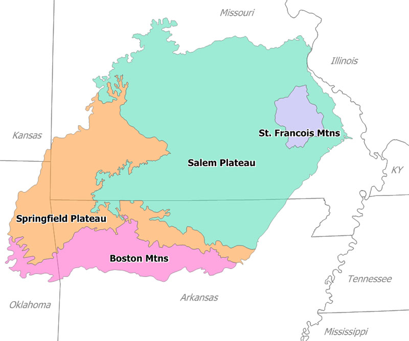
The Ouachita Mountains (), simply referred to as the Ouachitas, are a mountain range in western Arkansas and southeastern Oklahoma. They are formed by a thick succession of highly deformed Paleozoic strata constituting the Ouachita Fold and Thrust Belt, one of the important orogenic belts of North America. The Ouachitas continue in the subsurface to the southeast, where they make a poorly understood connection with the Appalachians and to the southwest, where they join with the Marathon uplift area of West Texas. Together with the Ozark Plateaus, the Ouachitas form the U.S. Interior Highlands. The highest natural point is Mount Magazine at 2,753 feet (839 m).

The Ouachita Mountains is a Level III ecoregion designated by the Environmental Protection Agency (EPA). The region has been subdivided into six Level IV ecoregions.

Adapted from Wikipedia: Ouachita Mountains (CC BY-SA 4.0).

Feature class
Range/mtn
Mapped extent
48,845 km²
Size rank
#83 of 216 mountain ranges
Region
North America
Coordinates
34.6485°, -93.6993°
Summits:
Magazine Mountain (839 m), Clingmans Dome (2,025 m), Fishers Peak (2,934 m)
Adjacent ranges:
Blue Ridge (North America), Front Range (North America)
Settlements:
Hot Springs (61 km), Fort Smith (104 km), Conway (124 km)

View on the live map

More about Ouachita Mountains

Geography

The Ouachitas are a major physiographic province of Arkansas and Oklahoma and are generally grouped with the Arkansas River Valley. Together with the Ozark Plateaus, the Ouachitas form the U.S. Interior Highlands, one of few mountainous regions between the Appalachians and Rockies.

The Ouachitas are dominated by pine, oak, and hickory. The shortleaf pine (Pinus echinata) and post oak (Quercus stellata) thrive in dry, nutrient-poor soil and are common in upland areas. The maple-leaf oak (Quercus acerifolia) is found at only four sites worldwide, all of which are in the Ouachitas. Some native tree species, such as the eastern red-cedar (Juniperus virginiana), are colonizers of human-disturbed sites.

The Ouachita National Forest covers approximately 1.8 million acres of the Ouachitas.

Geology

The Ouachitas are formed by a thick succession of highly deformed Paleozoic strata constituting the Ouachita Fold and Thrust Belt, which crops out for approximately 220 miles (350 km) in western Arkansas and southeastern Oklahoma. In a general sense, the Ouachitas are considered an anticlinorium because the oldest known rocks are located towards the center of the outcrop area. The Ouachitas continue in the subsurface to the Black Warrior Basin of Alabama and Mississippi where they plunge towards the Appalachian Mountains. To the southwest, the Ouachitas join with the Marathon area of west Texas where rocks of the Ouachita Fold and Thrust Belt are briefly exposed.

Unlike many ranges in the United States, the Ouachitas are mostly east-west trending.

History

The mountains were home to the Ouachita tribe, for which they were named. Later French explorers translated the name to its present spelling. The first recorded exploration was in 1541 by Hernando de Soto. Later, in 1804, President Jefferson sent William Dunbar and Dr. George Hunter to the area after the Louisiana Purchase. Hot Springs National Park became one of the nation's first parks in 1832. The Battle of Devil's Backbone was fought here at the ridge of the same name in 1863. In August 1990, the U.S. Forest Service discontinued clearcutting as the primary tool for harvesting and regenerating short leaf, pine and hardwood forests in the Ouachita National Forest.

Tourism

The Ouachita Mountains contain the Ouachita National Forest, Hot Springs National Park and Lake Ouachita, as well as numerous state parks and scenic byways mostly throughout Arkansas. They also contain the Ouachita National Recreation Trail, a 223-mile-long (359 km) hiking trail through the heart of the mountains. The trail runs from Talimena State Park in Oklahoma to Pinnacle Mountain State Park near Little Rock. It is a well maintained, premier trail for hikers, backpackers, and mountain bikers (for only selected parts of the trail).

Sections adapted from Wikipedia: Ouachita Mountains (CC BY-SA 4.0).

Ouachita Mountains: Key Facts

Key facts about Ouachita Mountains
Length320 km
Area123,085 km²
Highest pointMount Magazine
Part ofU.S. Interior Highlands

Facts from Wikidata Q2033447 (CC0).

Yukon Flats
Image via Wikimedia Commons (author and licence on the file page).

Yukon Flats

Plain · 39,325 km²

Yukon Flats is a plain in North America, covering an estimated 39,325 km².

The Yukon Flats are a vast area of wetlands, forest, bog, and low-lying ground centered on the confluence of the Yukon River, Porcupine River, and Chandalar River in the central portion of the U.S. state of Alaska. The Yukon Flats are bordered in the north by the Brooks Range, in the south by the White Mountains, and cover an area of approximately 11,000 square miles (28,490 km2). The Yukon Flats are a critical waterfowl breeding ground due to the large area of wetland provided by the estimated 40,000 small lakes and streams in the area. In recognition of this fact, the area is protected under the Yukon Flats National Wildlife Refuge.

The Yukon Flats straddle the Arctic Circle and have an extremely variable climate. Temperatures of 95 F (35 °C) are not uncommon in summer, while winter temperatures have been known to drop to -70 F (-57 °C).

Several hundred Alaska Natives and others live in the Yukon Flats area. Though most of the region's people are concentrated in the villages of Fort Yukon, Venetie, Beaver, Stevens Village, Chalkyitsik, and smaller settlements, numerous hunting cabins and seasonal settlements also dot the region.

Adapted from Wikipedia: Yukon Flats (CC BY-SA 4.0).

Feature class
Plain
Mapped extent
39,325 km²
Size rank
#87 of 231 landforms
Region
North America
Coordinates
66.6884°, -144.7497°
Summits:
Mount Frank Rae (2,347 m), Denali (6,194 m), Mount Blackburn (4,996 m)
Ranges:
Ogilvie Mountains (North America), Wrangell Mountains (North America)
Settlements:
Fairbanks (246 km), Anchorage (657 km), Whitehorse (816 km)

View on the live map

Bitterroot Range
Image via Wikimedia Commons (author and licence on the file page).

Bitterroot Range

Range/mtn · 34,228 km²

Bitterroot Range is a range/mtn in North America, covering an estimated 34,228 km².

The Bitterroot Range is a mountain range and a subrange of the Rocky Mountains that runs along the border of Montana and Idaho in the northwestern United States. The range spans an area of 24,223 square miles (62,740 km2) and is named after the bitterroot (Lewisia rediviva), a small pink flower that is the state flower of Montana.

Adapted from Wikipedia: Bitterroot Range (CC BY-SA 4.0).

Feature class
Range/mtn
Mapped extent
34,228 km²
Size rank
#101 of 216 mountain ranges
Region
North America
Coordinates
47.7302°, -116.1644°
Summits:
Mount Rainier (4,392 m), Mount Baker (3,286 m), Mount Sir Sandford (3,519 m)
Adjacent ranges:
Salmon River Mountains (North America), Cascade Range (North America)
Settlements:
Coeur d'Alene (46 km), Spokane (94 km), Kalispell (147 km)

View on the live map

More about Bitterroot Range

History

1805, the Corps of Discovery, led by Meriwether Lewis and William Clark and aided by Sacajawea of the Shoshone tribe, crossed the Bitterroot Range several times. Lewis first crossed the mountains at Lemhi Pass on August 12, then returned across the pass to meet Clark. The entire expedition then crossed the pass to the Salmon River valley, and the next month entered the Bitterroot Valley from the south via either Lost Trail Pass or Chief Joseph Pass. It then crossed Lolo Pass to the west. In June 1806 the Corps of Discovery was then led by 5 members of the Nez Percé back across the Bitterroot Range, from west to east. The Bitterroots also presented a massive problem for the expedition, ending their hope of finding an all water Northwest Passage.

Sections adapted from Wikipedia: Bitterroot Range (CC BY-SA 4.0).

Bitterroot Range: Key Facts

Key facts about Bitterroot Range
Area38,182 km²
Highest pointScott Peak
Part ofRocky Mountains

Facts from Wikidata Q879014 (CC0).

Great Lakes
Image via Wikimedia Commons (author and licence on the file page).

Great Lakes

Lake · 31,369 km²

Great Lakes is a lake in North America, covering an estimated 31,369 km². It extends across Canada and the United States.

The Great Lakes, also called the Great Lakes of North America, are a series of large interconnected freshwater lakes spanning the Canada–United States border. The five lakes are Superior, Michigan, Huron, Erie, and Ontario (though hydrologically, Michigan and Huron are a single body of water, joined at the Straits of Mackinac). The Great Lakes Waterway enables modern travel and shipping by water among the lakes. The lakes connect ultimately to the Atlantic Ocean via the Saint Lawrence River as their primary drainage outflow. The lakes are also connected to the Mississippi River basin through the Illinois Waterway.

The Great Lakes are the largest group of freshwater lakes on Earth by total area and the second-largest by total volume. They contain more than 20% of the world's surface fresh water by volume. The total surface is 94,250 square miles (244,106 km2), and the total volume (measured at the low water datum) is 5,439 cubic miles (22,671 km3), slightly less than the volume of Lake Baikal (5,666 cu mi or 23,615 km3, 22–23% of the world's surface fresh water).

Adapted from Wikipedia: Great Lakes (CC BY-SA 4.0).

Feature class
Lake
Mapped extent
31,369 km²
Size rank
#94 of 231 landforms
Region
North America
Countries
Canada, United States
Coordinates
48.2841°, -86.9007°
Summits:
Spruce Knob (1,482 m), Mount Marcy (1,269 m), Balsam Beartown Mountain (1,436 m)
Ranges:
Blue Ridge (North America), Black Hills (North America)
Settlements:
Marquette (85 km), Marinette (148 km), Sault Ste. Marie (167 km)

View on the live map

More about Great Lakes

Geography

Though the five lakes lie in separate basins, they form a single, naturally interconnected body of fresh water, within the Great Lakes Basin. As a chain of lakes and rivers, they connect the east-central interior of North America to the Atlantic Ocean. From the interior to the outlet at the Saint Lawrence River, water flows from Superior to Huron and Michigan, southward to Erie, and finally northward to Lake Ontario. The lakes drain a large watershed via many rivers and contain approximately 35,000 islands. There are also several thousand smaller lakes, often called "inland lakes", within the basin.

Geology

It has been estimated that the foundational geology that created the conditions shaping the present day upper Great Lakes was laid from 1.1 to 1.2 billion years ago, when two previously fused tectonic plates split apart and created the Midcontinent Rift, which crossed the Great Lakes Tectonic Zone. A valley was formed providing a basin that eventually became modern day Lake Superior. When a second fault line, the Saint Lawrence rift, formed approximately 570 million years ago, the basis for Lakes Ontario and Erie was created, along with what would become the Saint Lawrence River.

The Great Lakes are estimated to have been formed at the end of the Last Glacial Period (the Wisconsin glaciation ended 10,000 to 12,000 years ago), when the Laurentide Ice Sheet receded.

Climate

Köppen climate classification Dfa (in southern areas) and Dfb (in northern parts) with varying influences from air masses from other regions including dry, cold Arctic systems, mild Pacific air masses from the west, and warm, wet tropical systems from the south and the Gulf of Mexico. The lakes have a moderating effect on the climate; they can also increase precipitation totals and produce lake effect snowfall.

The Great Lakes can have an effect on regional weather called lake-effect snow, which is sometimes very localized. Even late in winter, the lakes often have no icepack in the middle. The prevailing winds from the west pick up the air and moisture from the lake surface, which is slightly warmer in relation to the cold surface winds above.

Ecology

Historically, the Great Lakes, in addition to their lake ecology, were surrounded by various forest ecoregions (except in a relatively small area of southeast Lake Michigan where savanna or prairie occasionally intruded). Logging, urbanization, and agriculture uses have changed that relationship. In the early 21st century, Lake Superior's shores are 91% forested, Lake Huron 68%, Lake Ontario 49%, Lake Michigan 41%, and Lake Erie, where logging and urbanization has been most extensive, 21%. Some of these forests are second or third growth (i.e. they have been logged before, changing their composition).

Sections adapted from Wikipedia: Great Lakes (CC BY-SA 4.0).

Great Lakes: Key Facts

Key facts about Great Lakes
Area208,610 km²

Facts from Wikidata Q7347 (CC0).

Wrangell Mountains
Image via Wikimedia Commons (author and licence on the file page).

Wrangell Mountains

Range/mtn · 25,572 km²

Wrangell Mountains is a range/mtn in North America, covering an estimated 25,572 km².

The Wrangell Mountains are a high mountain range of eastern Alaska in the United States. Much of the range is included in Wrangell-Saint Elias National Park and Preserve. The Wrangell Mountains are almost entirely volcanic in origin, and they include the second and third highest volcanoes in the United States, Mount Blackburn and Mount Sanford. The range takes its name from Mount Wrangell, which is one of the largest andesite shield volcanoes in the world, and also the only presently active volcano in the range. The Wrangell Mountains comprise most of the Wrangell Volcanic Field, which also extends into the neighboring Saint Elias Mountains and the Yukon Territory in Canada.

The Wrangell Mountains are just to the northwest of the Saint Elias Mountains and northeast of the Chugach Mountains, which are along the coast of the Gulf of Alaska. These ranges have the combined effect of blocking the inland areas from warmer moist air over the Pacific Ocean. The inland areas to the north of the Wrangell Mountains are therefore among the coldest areas of North America during the winter.

Adapted from Wikipedia: Wrangell Mountains (CC BY-SA 4.0).

Feature class
Range/mtn
Mapped extent
25,572 km²
Size rank
#116 of 216 mountain ranges
Region
North America
Coordinates
62.0885°, -143.4454°
Summits:
Mount Blackburn (4,996 m), Mount Logan (5,959 m), Mount Frank Rae (2,347 m)
Adjacent ranges:
Ogilvie Mountains (North America), Alaska Range (North America)
Settlements:
Anchorage (354 km), Fairbanks (372 km), Whitehorse (472 km)

View on the live map

More about Wrangell Mountains

Wrangell Mountains: Key Facts

Key facts about Wrangell Mountains
Highest pointMount Blackburn
Part ofPacific Coast Ranges

Facts from Wikidata Q616559 (CC0).

Front Range
Image via Wikimedia Commons (author and licence on the file page).

Front Range

Range/mtn · 25,274 km²

Front Range is a range/mtn in North America, covering an estimated 25,274 km².

The Front Range is a mountain range of the Southern Rocky Mountains of North America located in the central portion of the U.S. State of Colorado, and southeastern portion of the U.S. State of Wyoming. It is the first mountain range encountered as one goes westbound along the 40th parallel north across the Great Plains of North America.

The Front Range runs north–south between Casper, Wyoming, and Pueblo, Colorado, and rises nearly 10,000 feet above the Great Plains. Longs Peak, Mount Blue Sky, and Pikes Peak are its most prominent peaks, visible from the Interstate 25 corridor. The area is a popular destination for mountain biking, hiking, climbing, and camping during the warmer months and for skiing and snowboarding during winter. Millions of years ago, the present-day Front Range was home to ancient mountain ranges, deserts, beaches, and even oceans.

The name "Front Range" is also applied to the Front Range urban corridor, the populated region of Colorado and Wyoming just east of the mountain range and extending from Cheyenne, Wyoming south to Pueblo, Colorado.

Adapted from Wikipedia: Front Range (CC BY-SA 4.0).

Feature class
Range/mtn
Mapped extent
25,274 km²
Size rank
#117 of 216 mountain ranges
Region
North America
Coordinates
38.9289°, -105.3968°
Summits:
Mount Elbert (4,402 m), Fishers Peak (2,934 m), Mount Peale (3,877 m)
Adjacent ranges:
Rocky Mountains (North America), Wasatch Range (North America)
Settlements:
Colorado Springs (53 km), Denver (97 km), Pueblo (98 km)

View on the live map

More about Front Range

Geology

About 1 billion years ago, a mass of magma rose to the surface through a much older mantle, cooling to form what is now known as the Precambrian Pikes Peak Granite. Over the next 500 million years, the granite eroded with no sedimentation forming over this first uplift, resulting in a local expression of the Great Unconformity. At about 500–300 million years ago, the region began to sink and sediments began to deposit in the newly formed accommodation space. Eroded granite produced sand particles that began to form strata, layers of sediment, in the sinking basin. Sedimentation would continue to take place until about 300 million years ago.

Sections adapted from Wikipedia: Front Range (CC BY-SA 4.0).

Front Range: Key Facts

Key facts about Front Range
Highest pointGrays Peak
Part ofRocky Mountains

Facts from Wikidata Q1470027 (CC0).

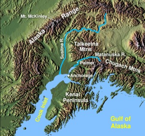
Kenai Peninsula
Image via Wikimedia Commons (author and licence on the file page).

Kenai Peninsula

Pen/cape · 24,588 km²

Kenai Peninsula is a pen/cape in North America, covering an estimated 24,588 km².

The Kenai Peninsula (Dena'ina: Yaghenen) is a large peninsula jutting from the coast of Southcentral Alaska. The name Kenai (, KEE-ny) is derived from the word "Kenaitze" or "Kenaitze Indian Tribe", the name of the Native Athabascan Alaskan tribe, the Kahtnuht’ana Dena’ina ("People along the Kahtnu (Kenai River)"), who historically inhabited the area. They called the Kenai Peninsula Yaghanen ("the good land").

Adapted from Wikipedia: Kenai Peninsula (CC BY-SA 4.0).

Feature class
Pen/cape
Mapped extent
24,588 km²
Size rank
#100 of 231 landforms
Region
North America
Coordinates
60.3855°, -150.2186°
Summits:
Redoubt Volcano (3,108 m), Denali (6,194 m), Mount Katmai (2,047 m)
Ranges:
Alaska Range (North America), Wrangell Mountains (North America)
Settlements:
Anchorage (94 km), Fairbanks (511 km), Whitehorse (828 km)

View on the live map

More about Kenai Peninsula

Geography

The peninsula extends about 150 miles (240 km) southwest from the Chugach Mountains, south of Anchorage. It is separated from the mainland on the west by Cook Inlet and on the east by Prince William Sound. Most of the peninsula is part of the Kenai Peninsula Borough. Athabaskan and Alutiiq Native groups lived on the peninsula for thousands of years prior to colonization during the Russian America era.

The glacier-covered Kenai Mountains run along the southeast spine of the peninsula along the coast of the Gulf of Alaska. Much of the range is within Kenai Fjords National Park. The northwest coast along the Cook Inlet is flatter, dotted with numerous small lakes. Several larger lakes extend through the interior of the peninsula, including Skilak Lake and Tustumena Lake.

Natural resources and economy

The peninsula also has natural gas, petroleum, and coal deposits, as well as abundant commercial and personal-use fisheries. Tourism is a major industry, along with outfitting and guiding services for hunters and fishers. The Kenai Peninsula is known as "Alaska's Playground". Kenai National Wildlife Refuge encompasses nearly two million acres of the peninsula.

Sections adapted from Wikipedia: Kenai Peninsula (CC BY-SA 4.0).

Kenai Peninsula: Key Facts

Key facts about Kenai Peninsula
OnCook Inlet, Pacific Ocean

Facts from Wikidata Q60010 (CC0).

Mogollon Rim
Image via Wikimedia Commons (author and licence on the file page).

Mogollon Rim

Range/mtn · 18,745 km²

Mogollon Rim is a range/mtn in North America, covering an estimated 18,745 km².

The Mogollon Rim () is a topographical and geological feature cutting across the northern half of the U.S. state of Arizona. It extends approximately 200 miles (320 km), starting in northern Yavapai County and running eastward, ending near the border with New Mexico. It forms the southern edge of the Colorado Plateau in Arizona.

Adapted from Wikipedia: Mogollon Rim (CC BY-SA 4.0).

Feature class
Range/mtn
Mapped extent
18,745 km²
Size rank
#126 of 216 mountain ranges
Region
North America
Coordinates
34.2613°, -110.9922°
Summits:
Sierra Blanca Peak (3,649 m), Mount Peale (3,877 m), Picacho del Diablo (3,069 m)
Adjacent ranges:
Sierra Madre Occidental (North America), Wasatch Range (North America)
Settlements:
Mesa (116 km), Flagstaff (120 km), Phoenix (128 km)

View on the live map

More about Mogollon Rim

Description

The Rim is an escarpment defining the southwestern edge of the Colorado Plateau. Its central and most spectacular portions are characterized by high cliffs of limestone and sandstone, namely the Kaibab Limestone and Coconino Sandstone cliffs. The escarpment was created by erosion and faulting, creating canyons such as Fossil Creek Canyon and Pine Canyon. The name Mogollon comes from Don Juan Ignacio Flores Mogollón, the Spanish Governor of New Mexico from 1712 to 1715.

Much of the land south of the Mogollon Rim lies 4,000 to 5,000 feet (1,200 to 1,500 m) above sea level, with the escarpment rising to about 8,000 ft (2,400 m). Extensive Ponderosa pine forests are found both on the slopes of the Rim and on the plateau to the north.

Hydrology

The Mogollon rim drains an extensive area, and has numerous springs and creeks (perennial and intermittent) draining from it. The Verde Valley alone may have more than 820 natural springs, many of which originate from surface precipitation and subsurface waters of the Mogollon rim. Springs along the Mogollon rim can occur in almost all local rock types and the ground water flow system may be highly complex and spring water flow may be highly variable. Average annual precipitation along the Mogollon rim is also somewhat variable by location and elevation, some high areas along the edge of the rim and in high elevation canyons may receive in excess of 30-35 inches (762-889mm) of annual precipitation.

Sections adapted from Wikipedia: Mogollon Rim (CC BY-SA 4.0).

Ogilvie Mountains
Image via Wikimedia Commons (author and licence on the file page).

Ogilvie Mountains

Range/mtn · 15,686 km²

Ogilvie Mountains is a range/mtn in North America, covering an estimated 15,686 km². It extends across Canada and the United States.

The Ogilvie Mountains are a mountain range in the Yukon Territory of northwestern Canada.

Geologically they are part of the Yukon Ranges, in the upper Laramide Belt of the North American Cordillera.

Adapted from Wikipedia: Ogilvie Mountains (CC BY-SA 4.0).

Feature class
Range/mtn
Mapped extent
15,686 km²
Size rank
#137 of 216 mountain ranges
Region
North America
Countries
Canada, United States
Coordinates
64.6513°, -139.0679°
Summits:
Mount Blackburn (4,996 m), Chilkoot Pass (1,067 m), Denali (6,194 m)
Adjacent ranges:
Wrangell Mountains (North America), Alaska Range (North America)
Settlements:
Fairbanks (410 km), Anchorage (666 km), Juneau (746 km)

View on the live map

More about Ogilvie Mountains

Geography

The range lies north of Dawson City, and is crossed by the Dempster Highway.

The area was first surveyed by William Ogilvie and the range subsequently named after him.

The best known mountain peaks of the Ogilvie Mountains are located within Tombstone Territorial Park.

The highest mountain within the range is Mount Frank Rae, at 2,362 m (7,749 ft) in elevation.

Sections adapted from Wikipedia: Ogilvie Mountains (CC BY-SA 4.0).

Ogilvie Mountains: Key Facts

Key facts about Ogilvie Mountains
Area43,000 km²
Part ofYukon Ranges

Facts from Wikidata Q283784 (CC0).

Black Hills
Image via Wikimedia Commons (author and licence on the file page).

Black Hills

Range/mtn · 14,574 km²

Black Hills is a range/mtn in North America, covering an estimated 14,574 km².

The Black Hills are an outlying subrange of the greater Rocky Mountain system rising from the Great Plains of North America in western South Dakota and eastern Wyoming, United States. Black Elk Peak, which rises to 7,242 feet (2,207 m), is the range's highest summit. The name of the range in Lakota is Pahá Sápa. It encompasses the Black Hills National Forest. It formed as a result of an upwarping of ancient rock, after which the removal of the higher portions of the mountain mass by stream erosion produced the present-day topography. The Black Hills are part of the North American Cordillera, specifically a range within the Rocky Mountain Front of Wyoming, South Dakota, and Montana. The mountains are so called because of their dark appearance from a distance, as they are covered in evergreen trees.

American Indian tribes have a long history in the Black Hills and consider it a sacred site. After conquering the Cheyenne in 1776, the Lakota took the territory of the Black Hills, which became central to their culture.

Adapted from Wikipedia: Black Hills (CC BY-SA 4.0).

Feature class
Range/mtn
Mapped extent
14,574 km²
Size rank
#141 of 216 mountain ranges
Region
North America
Coordinates
44.1409°, -103.8669°
Summits:
Gannett Peak (4,207 m), Crazy Peak (3,417 m), Grand Teton (4,199 m)
Adjacent ranges:
Rocky Mountains (North America), Front Range (North America)
Settlements:
Rapid City (51 km), Gillette (132 km), Casper (243 km)

View on the live map

More about Black Hills

Geology

The geology of the Black Hills is complex. A Tertiary mountain-building episode is responsible for the uplift and current topography of the Black Hills region. This uplift was marked by volcanic activity in the northern Black Hills. The southern Black Hills are characterized by Precambrian granite, pegmatite, and metamorphic rocks that comprise the core of the entire Black Hills uplift. This core is rimmed by Paleozoic, Mesozoic, and Cenozoic sedimentary rocks. The stratigraphy of the Black Hills is laid out like a target, as it is an oval dome, with rings of different rock types dipping away from the center.

The 'bull's eye' of this target is called the granite core.

History

Although the written history of the region begins with the Sioux domination of the land over the native Arikara tribes, researchers have carbon-dating and stratigraphic records to analyze the early history of the area. Scientists have been able to utilize carbon-dating to evaluate the age of tools found in the area, which indicate a human presence that dates as far back as 11,500 BC with the Clovis culture.

The Black Hills have been inhabited by numerous indigenous groups over the centuries. The Ponca, Arikara, and Mandan were among the earliest recorded inhabitants, and were later displaced by the Kiowa, Plains Apache, and Shoshone. Those groups had largely left the area by around 1800 and returned only occasionally for trading or raids on other groups.

Tourism and economy

The region is home to Mount Rushmore National Memorial, Wind Cave National Park, Jewel Cave National Monument, Black Elk Peak, Custer State Park (the largest state park in South Dakota, and one of the largest in the US), Bear Butte State Park, Devils Tower National Monument, and the Crazy Horse Memorial. The Black Hills also hosts the Sturgis Motorcycle Rally each August. The rally was started in 1940 and the 65th Rally in 2005 saw more than 550,000 bikers visit the Black Hills. It is a key part of the regional economy.

The South Dakota Centennial Trail is a hiking and mountain biking trail which opened in 1989 to celebrate the 100th anniversary of South Dakota becoming a state.

Sections adapted from Wikipedia: Black Hills (CC BY-SA 4.0).

Black Hills: Key Facts

Key facts about Black Hills
Area12,950 km²
Highest pointBlack Elk Peak
Part ofRocky Mountains

Facts from Wikidata Q250937 (CC0).

Great Salt Lake Desert
Image via Wikimedia Commons (author and licence on the file page).

Great Salt Lake Desert

Desert · 10,522 km²

Great Salt Lake Desert is a desert in North America, covering an estimated 10,522 km².

The Great Salt Lake Desert (colloquially referred to as the West Desert) is a large dry lake in northern Utah between the Great Salt Lake and the Nevada border. It is a subregion of the larger Great Basin Desert and is noted for white evaporite Lake Bonneville salt deposits including the Bonneville Salt Flats.

Adapted from Wikipedia: Great Salt Lake Desert (CC BY-SA 4.0).

Feature class
Desert
Mapped extent
10,522 km²
Size rank
#44 of 58 deserts
Region
North America
Coordinates
40.8026°, -113.5306°
Summits:
Grand Teton (4,199 m), Gannett Peak (4,207 m), Mount Peale (3,877 m)
Ranges:
Wasatch Range (North America), Rocky Mountains (North America)
Settlements:
Salt Lake City (135 km), Ogden (140 km), Provo (171 km)

View on the live map

More about Great Salt Lake Desert

Climate

The Great Salt Lake Desert experiences a desert climate with hot summers and cold winters. The desert is an excellent example of a cold desert climate. The elevation, 4,250 feet above sea level, makes temperatures cooler than lower elevation deserts, such as the Mojave. The high elevation and aridity cause temperatures to drop sharply after sunset. Summer nights are comfortably cool. Winter highs are generally above freezing, and winter nights are cold, with temperatures often dropping below freezing.

History

During Jedediah Smith's 1826-27 expedition, Robert Evans nearly died while crossing the desert, and in the 1840s, westward emigrants used the Hastings Cutoff through 130 miles (210 km) of Great Salt Lake desert to reduce the distance to California. The 1846 Donner Party's difficulties in making the crossing contributed to their becoming snowbound in the Sierra Nevada. Howard Stansbury explored the desert in 1849. In 1956, I-80 replaced the Wendover Cut-off across the desert, including a straight east-west section for ~50 miles (80 km) between the Cedar Mountains to the east and Wendover on the Utah/Nevada border. Following a railway completed across the Bonneville Salt Flats in 1910, the flats were first used as a speedway in 1914.

Description

Several small mountain ranges occupy the edges of the desert, such as the Cedar Mountains, Lakeside Mountains, Silver Island Mountains, Hogup Mountains, Grassy Mountains, and Newfoundland Mountains. On the western edge of the desert, just across the border in Nevada, stands Pilot Peak in the Pilot Range.

The desert is cool during the winter and includes unusual plants adapted to the dry conditions. Most of the desert receives less than 8 inches (200 mm) of annual precipitation. The salt crust covering the desert reforms yearly when the rain evaporates. The military's Utah Test and Training Range is in the northern portion of the desert.

Sections adapted from Wikipedia: Great Salt Lake Desert (CC BY-SA 4.0).

Llano Estacado
Image via Wikimedia Commons (author and licence on the file page).

Llano Estacado

Plain · 10,403 km²

Llano Estacado is a plain in North America, covering an estimated 10,403 km².

The Llano Estacado (Spanish: [ˈʝano estaˈkaðo]), translated into English as the Staked Plains, is a region in the Southwestern United States encompassing parts of eastern New Mexico and northwestern Texas. One of the largest mesas or tablelands on the North American continent, the elevation rises from 3,000 feet (900 m) in the southeast to over 5,000 feet (1,500 m) in the northwest, sloping almost uniformly at about 10 feet per mile (2 m/km).

Adapted from Wikipedia: Llano Estacado (CC BY-SA 4.0).

Feature class
Plain
Mapped extent
10,403 km²
Size rank
#118 of 231 landforms
Region
North America
Coordinates
34.9740°, -104.1181°
Summits:
Sierra Blanca Peak (3,649 m), Fishers Peak (2,934 m), Mount Elbert (4,402 m)
Ranges:
Front Range (North America), Mogollon Rim (North America)
Settlements:
Clovis (105 km), Roswell (180 km), Santa Fe (183 km)

View on the live map

More about Llano Estacado

Geography and climate

The Llano Estacado lies at the southern end of the Western High Plains ecoregion of the Great Plains of North America; it is part of what was once called the Great American Desert. The Canadian River forms the Llano's northern boundary, separating it from the rest of the High Plains. To the east, the Caprock Escarpment, a precipitous cliff about 300 feet (100 m) high, lies between the Llano and the red Permian plains of Texas; while to the west, the Mescalero Ridge demarcates the eastern edge of the Pecos River valley. The Llano has no distinct southern boundary, instead blending into the Edwards Plateau near Big Spring, Texas.

Geology

When the weather is dry, they are dusty, round, gray, usually unvegetated flats, as observed from the highway. But after a High Plains thunderstorm, water quickly fills the ponds, only later soaking into the underlying porous sandstones just below the surface to add to the groundwater in the Ogallala aquifer. Early pioneers depended dearly on water from these surface ponds for themselves and their livestock, considering how few streams are on the High Plains. But rains didn't always come, and the ponds dried up frequently. The 20th century has witnessed a concerted effort to tap the more reliable Ogallala water sands.

History

In the early 18th century, the Comanches expanded their territory into the Llano Estacado, displacing the Apaches who had previously lived there. The region became part of the Comancheria, a Comanche stronghold until the final defeat of the tribe in the late 19th century. The Comanche war trail extended from Llano Estacado to the Rio Grande into Chihuahua, "the trail ran southwesterly through Big Spring to the Horsehead Crossing of the Pecos River, then forked southward to the Comanche Springs where it divided, one part of the trail crossing the great river near Boquillas and the other at Presidio."

Rachel Plummer, while a captive of the Comanche in 1836, mentioned the "table lands between Austin and Santa Fe".

Economy

The economy of the Llano Estacado is predominantly agricultural, with farming of various crops prevalent, as is cattle ranching. Oil and gas production is also intense throughout the Llano Estacado making it one of the most productive petrochemical areas in the United States.

Overuse of the aquifer in the past has persuaded some farmers to return to dryland crops, leading to less rainwater reaching the playas.

"Cotton, grain sorghum, corn, wheat, peanuts, sunflowers, grapes, vegetables, and cattle produced in the region literally go around the world. Their economic impact on our area is in the billions of dollars... and the availability of water is a key factor influencing the region's agribusiness economy."

Sections adapted from Wikipedia: Llano Estacado (CC BY-SA 4.0).

Llano Estacado: Key Facts

Key facts about Llano Estacado
Area97,000 km²

Facts from Wikidata Q1052758 (CC0).

Stikine Icecap
Image via Wikimedia Commons (author and licence on the file page).

Stikine Icecap

Glaciated areas · 6,670 km²

Stikine Icecap is a glaciated areas in Canada and the United States, covering an estimated 6,670 km². About 45% of the ice lies in the United States, and the rest in Canada. It is the 18th-largest of the 68 glaciers and ice fields with a mapped extent in YearMaps.

The Stikine Icecap (sometimes referred to as the Stikine Icefield) is a large icefield straddled on the Alaska–British Columbia boundary in the Alaska Panhandle region. It lies in the Boundary Ranges of the Coast Mountains. Within the United States, most of it is under the administration of the Tongass National Forest and is part of the Stikine-LeConte Wilderness within the national forest.

A good size icefield, the icecap is a primary source for both the Taku River, which forms its northern boundary, and the Taku's southern tributaries, and also the Stikine River and its lower western tributaries, notably the Chutine, which form its southern and southwestern boundary, respectively. The Stikine Icecap is the parent icefield of the LeConte and Sawyer Glaciers on its US side, and the Great Glacier on its Canadian side. Also on the Canadian side and entering the lower Stikine, like the Great Glacier, are the Mud and Flood Glaciers, which form the boundaries of the small Boundary Range, which is an eastern abutment of the range comprising the Stikine Icecap and marks the approximate boundary claimed by the United States prior to the Alaska Boundary Settlement of 1903.

Adapted from Wikipedia: Stikine Icecap (CC BY-SA 4.0).

Feature class
Glaciated areas
Mapped extent
6,670 km²
Size rank
#18 of 68 glaciers and ice fields
Countries
Canada, United States
Coordinates
57.2736°, -132.2595°
Summits:
Devils Paw (2,593 m), Chilkoot Pass (1,067 m), Mount Fairweather (4,671 m)
Ranges:
Cassiar Mountains (North America), Wrangell Mountains (North America)
Settlements:
Juneau (149 km), Anchorage (1,065 km), Fairbanks (1,155 km)

View on the live map

More about Stikine Icecap

Stikine Icecap: Key Facts

Key facts about Stikine Icecap
Area21,869 km²
Mountain rangeCoast Mountains

Facts from Wikidata Q2268498 (CC0).

Juneau Icefield
Image via Wikimedia Commons (author and licence on the file page).

Juneau Icefield

Glaciated areas · 5,407 km²

Juneau Icefield is a glaciated areas in the United States and Canada, covering an estimated 5,407 km². About 65% of the ice lies in the United States, and the rest in Canada. It is the 22nd-largest of the 68 glaciers and ice fields with a mapped extent in YearMaps.

The Juneau Icefield is an ice field located just north of Juneau, Alaska, continuing north through the border with British Columbia, extending through an area of 3,900 square kilometres (1,500 mi2) in the Coast Range ranging 140 km (87 mi) north to south and 75 km (47 mi) east to west. The icefield is the source of many glaciers, including the Mendenhall Glacier and the Taku Glacier. The icefield is home to over 40 large valley glaciers and 100 smaller ones. The Icefield serves as a tourist attraction with many travellers flown in by helicopter for quick walks on the 240-to-1,400-metre (790 to 4,590 ft) deep ice and the massive, awe-inspiring moist crevasses.

Adapted from Wikipedia: Juneau Icefield (CC BY-SA 4.0).

Feature class
Glaciated areas
Mapped extent
5,407 km²
Size rank
#22 of 68 glaciers and ice fields
Countries
United States, Canada
Coordinates
58.5830°, -134.3802°
Summits:
Devils Paw (2,593 m), Chilkoot Pass (1,067 m), Mount Fairweather (4,671 m)
Ranges:
Cassiar Mountains (North America), Wrangell Mountains (North America)
Settlements:
Juneau (55 km), Anchorage (895 km), Fairbanks (961 km)

View on the live map

More about Juneau Icefield

History

This glacier was advancing in 1890 when viewed by John Muir, and had a large calving front. By 1963, the glacier had advanced 5.6 km (3.5 mi). In 1948, the Taku Fjord had been completely filled in with glacial sediment and the glacier no longer calved. From 1948–1986, the glacier had a positive glacier mass balance driving the advance. From 1987–2009, the glacier has had a slightly negative mass balance, not enough to end the advance, but if it continues will soon slow it.

The icefield, like many of its glaciers, reached its maximum glaciation point around 1700 and has been in retreat since. Much of the icefield is contained within the Tongass National Forest. Since 1948, the Juneau Icefield Research Program has monitored glaciers of the Juneau Icefield.

Sections adapted from Wikipedia: Juneau Icefield (CC BY-SA 4.0).

Juneau Icefield: Key Facts

Key facts about Juneau Icefield
Mountain rangeCoast Mountains

Facts from Wikidata Q1518380 (CC0).

Edwards Plateau
Image via Wikimedia Commons (author and licence on the file page).

Edwards Plateau

Plateau · 4,483 km²

Edwards Plateau is a plateau in North America, covering an estimated 4,483 km².

The Edwards Plateau is a geographic region forming the crossroads of Central, South, and West Texas, United States. It is named in honor of Haden Edwards. It is bounded by the Balcones Fault to the south and east; the Llano Uplift and the Llano Estacado to the north; and the Pecos River and Chihuahuan Desert to the west. San Angelo, Austin, San Antonio, and Del Rio roughly outline the area. The plateau, especially its southeast portion, is also known as the Texas Hill Country.

Adapted from Wikipedia: Edwards Plateau (CC BY-SA 4.0).

Feature class
Plateau
Mapped extent
4,483 km²
Size rank
#65 of 69 plateaus
Region
North America
Coordinates
31.5726°, -101.5352°
Summits:
Sierra Blanca Peak (3,649 m), Fishers Peak (2,934 m), Cerro San Rafael (3,710 m)
Ranges:
Sierra Madre Occidental (North America), Ouachita Mountains (North America)
Settlements:
Midland (74 km), Big Spring (75 km), Odessa (84 km)

View on the live map

More about Edwards Plateau

Natural history

The bedrock consists primarily of limestone, with elevations ranging between 100 and 3000 ft. Caves are numerous.

The landscape of the plateau is mostly savanna scattered with trees. It mostly lacks deep soil suitable for farming, though the soil type is fertile mollisol, so some cotton, grain sorghum, and oats are grown. For the most part, though, the thin soil and rough terrain areas are primarily grazing regions, with cattle, sheep, and goats (Angora and meat types) predominant. Several rivers cross the region, which generally flow to the south and east through the Texas Hill Country toward the Gulf of Mexico; springs occur (in wet years), but permanent surface water supplies are sparse throughout the area, except for man-made reservoirs.

Human history

First, it was used and wandered about by Jumano and Coahuiltecan groups, then the Apacheria extended into the Southern Plains by the forerunners of the Lipan and Mescalero Apaches. After the expulsion of the Apachean groups from the plains by the Comanche, this area was dominated by the Penateka band of the Southern Comanche.

Sections adapted from Wikipedia: Edwards Plateau (CC BY-SA 4.0).

Edwards Plateau: Key Facts

Key facts about Edwards Plateau
Elevation784 m

Facts from Wikidata Q1294308 (CC0).

Sea Islands
Image via Wikimedia Commons (author and licence on the file page).

Sea Islands

Coast · 4,192 km²

Sea Islands is a coast in North America, covering an estimated 4,192 km².

The Sea Islands are a chain of over one hundred tidal and barrier islands on the Atlantic Ocean coast of the Southeastern United States in the states of South Carolina, Georgia and Florida, roughly between the mouths of the Santee and Nassau rivers. The islands are part of the historical area of the Gullah Geechee people and the Gullah-Geechee Cultural Heritage Corridor. All of the islands are acutely threatened by sea level rise due to climate change.

Adapted from Wikipedia: Sea Islands (CC BY-SA 4.0).

Feature class
Coast
Mapped extent
4,192 km²
Size rank
#136 of 231 landforms
Region
North America
Coordinates
32.3667°, -80.5482°
Summits:
Mount Mitchell (2,037 m), Clingmans Dome (2,025 m), Mount Rogers (1,746 m)
Ranges:
Blue Ridge (North America), Ouachita Mountains (North America)
Settlements:
Beaufort (15 km), Savannah (65 km), Charleston (70 km)

View on the live map

More about Sea Islands

History

Settled by indigenous cultures thousands of years ago, the islands were selected by Spanish colonists as sites for founding of colonial missions. Historically the Spanish influenced the Guale and Mocama chiefdoms by establishing Christian missions in their major settlements, from St. Catherine's Island south, past the Sea Islands, to Fort George Island (at present-day Jacksonville, Florida).

Both chiefdoms extended to the coastal areas on the mainland. The Mocama Province included territory to the St. Johns River in present-day Florida. The mission system ended under pressure of repeated raids by English South Carolina colonists and Indian allies. Spain ceded its territory of Florida to Great Britain in 1763.

Sections adapted from Wikipedia: Sea Islands (CC BY-SA 4.0).

Grand Canyon
Image via Wikimedia Commons (author and licence on the file page).

Grand Canyon

Gorge · 3,722 km²

Grand Canyon is a gorge in North America, covering an estimated 3,722 km².

The Grand Canyon is a steep-sided canyon carved by the Colorado River in Arizona, United States. The Grand Canyon is 277 miles (446 km) long, up to 18 miles (29 km) wide and attains a depth of over a mile (6,093 feet or 1,857 meters).

The canyon and adjacent rim are contained within Grand Canyon National Park, the Kaibab National Forest, Grand Canyon–Parashant National Monument, the Hualapai Indian Reservation, the Havasupai Indian Reservation and the Navajo Nation. President Theodore Roosevelt was a major proponent of the preservation of the Grand Canyon area and visited it on numerous occasions to hunt and enjoy the scenery.

Nearly two billion years of Earth's geological history have been exposed as the Colorado River and its tributaries cut their channels through layer after layer of rock while the Colorado Plateau was uplifted. While some aspects about the history of incision of the canyon are debated by geologists, several recent studies support the hypothesis that the Colorado River established its course through the area about 5 to 6 million years ago.

Adapted from Wikipedia: Grand Canyon (CC BY-SA 4.0).

Feature class
Gorge
Mapped extent
3,722 km²
Size rank
#138 of 231 landforms
Region
North America
Coordinates
35.4413°, -113.4700°
Summits:
Mount Whitney (4,421 m), White Mountain Peak (4,342 m), Mount Peale (3,877 m)
Ranges:
Mogollon Rim (North America), Wasatch Range (North America)
Settlements:
Kingman (60 km), Bullhead City (105 km), Lake Havasu City (130 km)

View on the live map

More about Grand Canyon

Geography

The Grand Canyon is a river valley in the Colorado Plateau that exposes uplifted Proterozoic and Paleozoic strata, and it is also one of the six distinct physiographic sections of the Colorado Plateau province. Even though it is not the deepest canyon on land in the world (Kali Gandaki Gorge in Nepal is much deeper), the Grand Canyon is known for its visually overwhelming size and its intricate and colorful landscape. Geologically, it is significant because of the thick sequence of ancient rocks that are well preserved and exposed in the walls of the canyon. These rock layers record much of the early geologic history of the North American continent.

Uplift associated with mountain formation later moved these sediments thousands of feet upward and created the Colorado Plateau.

Geology

The Grand Canyon is part of the Colorado River basin, which has developed over the past 70 million years. For more than 150 years, scientists have gathered data, proposed new ideas, and debated sometimes contentious theories about the geologic origins of the Grand Canyon and the Colorado River. Formation of the Grand Canyon and the Colorado River may involve a complex history in which multiple factors and geologic processes have interacted over time and in different locations.

In the most recent round of "old river" vs. "young river" controversy, researchers have challenged estimates that had placed the age of the canyon at 5–6 million years. The research has aroused considerable controversy because it suggests a substantial departure from prior widely supported scientific consensus.

Climate change

Due to the increase of greenhouse gases, temperatures have steadily risen making recent years the warmest in the century-long record. Temperatures have increased in Arizona by 2.1 degrees Fahrenheit since 1895. From 1916 to 2014, naturalized streamflow in the Upper Colorado River Basin decreased by 16.5%, in spite of a slight increase of +1.4% in annual precipitation over the same period.

Increases in temperature correlate to increased evaporation, loss of reflective snow, and decreases in snowpack, reducing available water in the Colorado River by an estimated 9.3% per degree Celsius of warming.

Over the last 30 years, the South Rim of the Grand Canyon has averaged 13.4 inches of rainfall per year, while the North Rim has averaged 24 inches.

Biology and ecology

There are approximately 1,737 known species of vascular plants, 167 species of fungi, 64 species of moss, and 195 species of lichen found in Grand Canyon National Park. This variety is largely due to the 8,000 foot (2,400 m) elevation change from the Colorado River up to the highest point on the North Rim. Grand Canyon boasts a dozen endemic plants (known only within the Park's boundaries) while only ten percent of the Park's flora is exotic.

Sections adapted from Wikipedia: Grand Canyon (CC BY-SA 4.0).

Grand Canyon: Key Facts

Key facts about Grand Canyon
OnColorado River

Facts from Wikidata Q118841 (CC0).

Brooks Range
Image via Wikimedia Commons (author and licence on the file page).

Brooks Range

Range/mtn · 3,380 km²

Brooks Range is a range/mtn in North America, covering an estimated 3,380 km². It extends across the United States and Canada.

The Brooks Range (Gwich'in: Gwazhał) is a mountain range in far northern North America stretching some 700 miles (1,100 km) from west to east across northern Alaska into Canada's Yukon Territory. Reaching a peak elevation of 8,976 feet (2,736 m) on Mount Isto, the range is believed to be approximately 126 million years old.

In the United States, these mountains are considered a subrange of the Rocky Mountains, whereas in Canada they are considered separate, as the northern border of the Rocky Mountains is considered to be the Liard River far to the south in the province of British Columbia.

While the range is mostly uninhabited, the Dalton Highway and Trans-Alaska Pipeline System run through the Atigun Pass (1,415 m, 4,643 ft) on their way to the oil fields at Prudhoe Bay on Alaska's North Slope. The Alaska Native villages of Anaktuvuk and Arctic Village, as well as the very small communities of Coldfoot, Wiseman, Bettles, and Chandalar, are the range's only settlements. In the far west, near the Wulik River in the De Long Mountains is the Red Dog mine, the largest zinc mine in the world.

Adapted from Wikipedia: Brooks Range (CC BY-SA 4.0).

Feature class
Range/mtn
Mapped extent
3,380 km²
Size rank
#165 of 216 mountain ranges
Region
North America
Countries
United States, Canada
Coordinates
69.7037°, -163.8457°
Summits:
Denali (6,194 m), Mount Blackburn (4,996 m), Redoubt Volcano (3,108 m)
Adjacent ranges:
Ogilvie Mountains (North America), Wrangell Mountains (North America)
Settlements:
Fairbanks (284 km), Anchorage (701 km), Juneau (1,160 km)

View on the live map

More about Brooks Range

Climate

While other Alaskan ranges to the south and closer to the coast can receive 250 inches (640 cm) to 500 inches (1,300 cm) of snow, the average snow precipitation on the Brooks Range is reported at 30 inches (76 cm) to 51 inches (130 cm). Due to a changing climate, between the years 1969–2018 the Eastern and Western portions of the Brooks Range have experienced a 17.2% increase in annual precipitation.

As measured at the Anaktuvuk Pass weather station (elevation 770 metres (2,530 ft)), the average summer temperatures are 16 °C (61 °F) as a high and 3 °C (37 °F) as a low. During the winter the average high is −22 °C (−8 °F) while the average low is −30 °C (−22 °F). Polar amplification is a force experienced in this region as global temperatures are rising.

Ecology

The Brooks Range forms the northernmost drainage divide in North America, separating streams flowing into the Arctic Ocean and the North Pacific. The range roughly delineates the summer position of the Arctic front. It represents the northern extent of the tree line, with little beyond isolated balsam poplar stands occurring north of the continental drainage divide. Trembling aspen and white spruce also occur north of the Brooks Range, though they are limited to sites that have been disturbed by human activity. Southern slopes have some cover of black spruce, Picea mariana, marking the northern limit of those trees. As the global mean temperature increases, tree line has been observed to move further north, changing the boundaries of where these trees are found.

History

Bob Marshall explored the North Fork Koyukuk River area of the range in 1929. He named Mount Doonerak, explaining "the name Doonerak I took from an Eskimo word which means a spirit or, as they would translate it, a devil." Marshall described the mountain as, a "towering, black, unscalable-looking giant, the highest peak in this section of the Brooks Range."

Sections adapted from Wikipedia: Brooks Range (CC BY-SA 4.0).

Brooks Range: Key Facts

Key facts about Brooks Range
Length1,100 km
Highest pointMount Isto
Part ofNorth American Cordillera

Facts from Wikidata Q929910 (CC0).

Malaspina Glacier
Image via Wikimedia Commons (author and licence on the file page).

Malaspina Glacier

Glaciated areas · 3,096 km²

Malaspina Glacier is a glaciated areas in the United States, covering an estimated 3,096 km².

The Malaspina Glacier (Tlingit: Sít’ Tlein) in southeastern Alaska is the largest piedmont glacier in the world. Situated at the head of the Alaska Panhandle, it is about 65 km (40 mi) wide and 45 km (28 mi) long, with an area of some 3,900 km2 (1,500 sq mi), approximately the same size as the state of Rhode Island.

Adapted from Wikipedia: Malaspina Glacier (CC BY-SA 4.0).

Feature class
Glaciated areas
Mapped extent
3,096 km²
Size rank
#27 of 68 glaciers and ice fields
Coordinates
59.9108°, -140.6442°
Summits:
Mount Logan (5,959 m), Mount Fairweather (4,671 m), Mount Blackburn (4,996 m)
Ranges:
Wrangell Mountains (North America), Ogilvie Mountains (North America)
Settlements:
Whitehorse (321 km), Juneau (397 km), Anchorage (526 km)

View on the live map

More about Malaspina Glacier

Geography

The Malaspina Glacier actually comprises Seward Glacier, Agassiz Glacier, and Marvine/Hayden Glacier, which converge as they spill out from the Saint Elias Mountains onto the coastal plain facing the Gulf of Alaska between Icy Bay and Yakutat Bay. Officially, these three glaciers are classified independently, such that Malaspina Glacier does not technically exist. The three glaciers are almost always referred to together, though sometimes only the largest primary piedmont lobe is referred to as Malaspina Glacier. This notable feature is actually part of Seward Glacier, with Agassiz Glacier contributing the secondary piedmont lobe to the west, and Marvine/Hayden Glacier constituting the smallest and most eastern lobe.

History

Radar data and aerial photographs dating back to 1972 provide evidence that the Malaspina-Seward glacier system lost about 20 m (66 ft) of its thickness between 1980 and 2000; because the glacier is so large, that amount of shrinkage was sufficient to contribute 0.5% of the rise in the global sea level.

Sections adapted from Wikipedia: Malaspina Glacier (CC BY-SA 4.0).

Malaspina Glacier: Key Facts

Key facts about Malaspina Glacier
Length45 km
Area3,900 km²
Mountain rangeSaint Elias Mountains

Facts from Wikidata Q617835 (CC0).

Harding Icefield
Image via Wikimedia Commons (author and licence on the file page).

Harding Icefield

Glaciated areas · 2,525 km²

Harding Icefield is a glaciated areas in the United States, covering an estimated 2,525 km².

The Harding Icefield is an expansive icefield located in the Kenai Mountains of the Kenai Peninsula in Alaska. It is also partially located in Kenai Fjords National Park. It is named for U.S. President Warren G. Harding.

Adapted from Wikipedia: Harding Icefield (CC BY-SA 4.0).

Feature class
Glaciated areas
Mapped extent
2,525 km²
Size rank
#30 of 68 glaciers and ice fields
Coordinates
60.0756°, -149.9815°
Summits:
Redoubt Volcano (3,108 m), Denali (6,194 m), Mount Katmai (2,047 m)
Ranges:
Alaska Range (North America), Wrangell Mountains (North America)
Settlements:
Anchorage (127 km), Fairbanks (542 km), Whitehorse (821 km)

View on the live map

More about Harding Icefield

Geography

The Harding Icefield is over 700 square miles (1,800 km2) in its entirety (although, if one were to count its glaciers which descend from the icefield in all directions, the icefield measures in at over 1,100 square miles (2,800 km2)) The icefield spawns up to 40 glaciers of all types. Some of the more notable glaciers include the Tustumena Glacier, Exit Glacier, and McCarty Glacier. The Exit Glacier, however, is the most accessible of the glaciers, being reached by a spur road off of the Seward Highway.

The icefield is also one of four remaining icefields in the United States and is the largest contained entirely within the United States. The icefield itself receives over 400 inches (10 m) of snow each year.

History

Residents of Seward, Alaska, generally ignored the huge icefield west of town before 1922. The construction of the Spruce Creek trail that year, however, made it possible to view the upper portions of the icecap, and President Harding's promise to visit the territory was sufficient to bestow his name on the feature. Between the mid-1920s and the early 1930s, the increasing popularity of aviation had given a lucky few the opportunity to soar over the icefield. Up to this point, however, settlers had walked only on the icefield's margins.

In early 1936, a 27-year-old Swiss immigrant and future state senator named Yule Kilcher disembarked in Seward.

Sections adapted from Wikipedia: Harding Icefield (CC BY-SA 4.0).

Harding Icefield: Key Facts

Key facts about Harding Icefield
Mountain rangeKenai Mountains

Facts from Wikidata Q1441249 (CC0).

Wasatch Range
Image via Wikimedia Commons (author and licence on the file page).

Wasatch Range

Range/mtn · 1,785 km²

Wasatch Range is a range/mtn in North America, covering an estimated 1,785 km².

The Wasatch Range ( WAH-satch) or Wasatch Mountains is a mountain range in the western United States that runs about 160 miles (260 km) from the Utah–Idaho border south to central Utah. It is the western edge of the greater Rocky Mountains, and the eastern edge of the Great Basin region. The northern extension of the Wasatch Range, the Bear River Mountains, extends just into Idaho, constituting all of the Wasatch Range in that state.

In the language of the native Ute people, wasatch means "mountain pass" or "low pass over high range." According to William Bright, the mountains were named for a Shoshoni leader who was named with the Shoshoni term wasattsi, meaning "blue heron". In 1926, Cecil Alter quoted Henry Gannett from 1902, who said that the word meant "land of many waters," then posited, "the word is a common one among the Shoshones, and is given to a berry basket" carried by women.

Adapted from Wikipedia: Wasatch Range (CC BY-SA 4.0).

Feature class
Range/mtn
Mapped extent
1,785 km²
Size rank
#173 of 216 mountain ranges
Region
North America
Coordinates
39.5279°, -111.7860°
Summits:
Mount Peale (3,877 m), Gannett Peak (4,207 m), Mount Elbert (4,402 m)
Adjacent ranges:
Rocky Mountains (North America), Front Range (North America)
Settlements:
Provo (81 km), Salt Lake City (139 km), Ogden (190 km)

View on the live map

More about Wasatch Range

Geography and geology

The Wasatch Range's origins are rooted in the Sevier Orogeny. As the Farallon plate subducted under the North American plate between the Jurassic and Paleogene, the regional stress regime became a maximum striking east to west. This horizontal compression caused thin skinned imbricated thrust faults resulting in as much as 50% crustal shortening of the western North American Plate. The Wasatch anticlinorium represented the furthest eastern margins of these Sevier origin imbricated thrusts. Once the Farallon plate had largely subducted, the NW moving Pacific plate latched onto the North American Plate, causing a change in regional stress.

Ecology

The Wasatch Range is part of the Wasatch and Uinta Mountains Level 3 Ecoregion, a temperate coniferous forest. Common trees include Douglas fir (Pseudotsuga menziesii), subalpine fir (Abies bifolia), Engelmann spruce (Picea engelmannii), Colorado blue spruce (Picea pungens), and quaking aspen (Populus tremuloides). Gambel oak (Quercus gambelii) is common on the foothills of the range from just south of Brigham City in the north, to the southern extension of the Wasatch Range. It is not found in the northern portion of the Range. Ponderosa pine (Pinus ponderosa), while abundant elsewhere in Utah is not common in this mountain range, except in plantations in Big Cottonwood Canyon southeast of Salt Lake City and in Logan Canyon, east of Logan.

Overview

Since the earliest days of European settlement, most of Utah's population has chosen to settle along the range's western front, where numerous rivers exit the mountains. For early settlers, the mountains were a vital source of water, timber, and granite. Today, 85% of Utah's population lives within 15 miles (24 km) of the Wasatch Range, mainly in the valleys just to the west. This westside concentration is known as the Wasatch Front and has a population just shy of 3 million. Salt Lake City lies between the Wasatch Range and the Great Salt Lake.

The range's highest point — 11,928 feet (3,636 m) — is Mount Nebo, a triple peak rising above Nephi, at the southern end of the range.

Sections adapted from Wikipedia: Wasatch Range (CC BY-SA 4.0).

Wasatch Range: Key Facts

Key facts about Wasatch Range
Length400 km
Highest pointMount Nebo
Part ofRocky Mountains

Facts from Wikidata Q1544388 (CC0).

Bering Glacier
Image via Wikimedia Commons (author and licence on the file page).

Bering Glacier

Glaciated areas · 1,646 km²

Bering Glacier is a glaciated areas in the United States, covering an estimated 1,646 km².

Glacier is a glacier in the U.S. state of Alaska. It currently terminates in Vitus Lake south of Alaska's Wrangell-St. Elias National Park, about 10 km (6.2 mi) from the Gulf of Alaska. Combined with the Bagley Icefield, where the snow that feeds the glacier accumulates, the Bering is the largest glacier in North America. The glacier is named after Vitus Bering.

Adapted from Wikipedia: Bering Glacier (CC BY-SA 4.0).

Feature class
Glaciated areas
Mapped extent
1,646 km²
Size rank
#33 of 68 glaciers and ice fields
Coordinates
60.2402°, -143.6180°
Summits:
Mount Blackburn (4,996 m), Mount Logan (5,959 m), Mount Fairweather (4,671 m)
Ranges:
Wrangell Mountains (North America), Alaska Range (North America)
Settlements:
Anchorage (358 km), Whitehorse (472 km), Fairbanks (552 km)

View on the live map

More about Bering Glacier

Bering Glacier: Key Facts

Key facts about Bering Glacier
Mountain rangeChugach Mountains

Facts from Wikidata Q2669909 (CC0).

Black Rock Desert
Image via Wikimedia Commons (author and licence on the file page).

Black Rock Desert

Desert · 1,556 km²

Black Rock Desert is a desert in North America, covering an estimated 1,556 km².

The Black Rock Desert is a semi-arid region (in the Great Basin shrub steppe ecoregion) of lava beds and playa, or alkali flats, situated in the Black Rock Desert–High Rock Canyon Emigrant Trails National Conservation Area, a silt playa 100 miles (160 km) north of Reno, Nevada, that encompasses more than 300,000 acres (120,000 ha) of land and contains more than 120 miles (200 km) of historic trails. It is in the northern Nevada section of the Great Basin with a lakebed that is a dry remnant of Pleistocene Lake Lahontan.

The Great Basin, named for the geography in which water is unable to flow out and remains in the basin, is a rugged land serrated by hundreds of mountain ranges, dried by wind and sun, with spectacular skies and scenic landscapes. The average annual precipitation (in the years 1971–2000) at Gerlach (in the extreme south-west of the desert) is 7.90 inches (200 mm).

The region is notable for its paleogeologic features, as an area of 19th-century Emigrant Trails to California, as a venue for rocketry, and as an alternative to the Bonneville Salt Flats in northwestern Utah for setting land speed records (Mach 1.02 in 1997).

Adapted from Wikipedia: Black Rock Desert (CC BY-SA 4.0).

Feature class
Desert
Mapped extent
1,556 km²
Size rank
#49 of 58 deserts
Region
North America
Coordinates
40.8713°, -119.0706°
Summits:
Mount Shasta (4,322 m), Mount Eddy (2,751 m), White Mountain Peak (4,342 m)
Ranges:
Sierra Nevada (North America), Klamath Mountains (North America)
Settlements:
Reno (162 km), Carson City (199 km), Chico (267 km)

View on the live map

More about Black Rock Desert

Geography

The Black Rock Desert region is in northwestern Nevada and the northwestern Great Basin. The playa extends for approximately 100 mi (160 km) northeast from the towns of Gerlach and Empire, between the Jackson Mountains to the east and the Calico Hills to the west.

The Black Rock Desert is separated into two arms by the Black Rock Range. It lies at an elevation of 3,907 ft (1,191 m) and has an area of about 1,000 sq mi (2,600 km2).

There are several possible definitions of the extent of the Black Rock Desert. Often, people refer only to the playa surface. Sometimes, terrain which can be seen from the playa is included. The widest definition of the Black Rock Desert region is the watershed of the basin that drains into the playa.

History

More than ~15,000 years ago (15 tya), the Humboldt River flowed to the Smoke Creek–Black Rock Desert sub-basin, and during the recession of Lake Lahontan, the river diverted to the Carson Desert sub-basin. During the highest Lahontan water level (~12.7 kya), the lakebed was under about 500 ft (150 m) of water, under which sediment accumulated to form a flat lakebed.

Great Basin tribes inhabited the area approximately 10,000 B.P., and a Frémont Expedition encountered the site in 1843, but the Fortieth Parallel Survey (1867) conducted the first official exploration. In the late 1840s, Peter Lassen led California Trail emigrants through the desert's Applegate-Lassen Cutoff, an arduous route that took them hundreds of miles away from the gold lands of California.

Sections adapted from Wikipedia: Black Rock Desert (CC BY-SA 4.0).

Black Rock Desert: Key Facts

Key facts about Black Rock Desert
Area2,590 km²

Facts from Wikidata Q880529 (CC0).

Sargent Icefield

Glaciated areas · 1,435 km²

Sargent Icefield is a glaciated areas in the United States, covering an estimated 1,435 km².

The Sargent Icefield is a large icefield located on the eastern portion of the Kenai Peninsula bordering Prince William Sound in Alaska. The ice field has numerous outflow glaciers including the Chenega, Princeton, and Ellsworth Glaciers.

Adapted from Wikipedia: Sargent Icefield (CC BY-SA 4.0).

Feature class
Glaciated areas
Mapped extent
1,435 km²
Size rank
#34 of 68 glaciers and ice fields
Coordinates
60.1852°, -148.7149°
Summits:
Redoubt Volcano (3,108 m), Mount Blackburn (4,996 m), Denali (6,194 m)
Ranges:
Alaska Range (North America), Wrangell Mountains (North America)
Settlements:
Anchorage (132 km), Fairbanks (520 km), Whitehorse (750 km)

View on the live map

Ozark Plateau
Image via Wikimedia Commons (author and licence on the file page).

Ozark Plateau

Plateau · 1,015 km²

Ozark Plateau is a plateau in North America, covering an estimated 1,015 km².

The Ozarks, also known as the Ozark Mountains, Ozark Highlands or Ozark Plateau, are a physiographic region in the U.S. states of Missouri, Arkansas, and Oklahoma, as well as a small area in the southeastern corner of Kansas. The Ozarks cover a significant portion of northern Arkansas and most of the southern half of Missouri, extending from Interstate 40 in central Arkansas to Interstate 70 in central Missouri.

There are two mountain ranges in the Ozarks: the Boston Mountains of Arkansas and Oklahoma, as well as the St. Francois Mountains of Missouri. Wahzhazhe Summit (formerly known as Buffalo Lookout), is the highest point in the Ozarks at 2,561 feet (781 m), and is located in the Boston Mountains, in the westernmost part of Newton County, Arkansas, 6.2 miles (10.0 km) east of Boston, Madison County, Arkansas. Geologically, the area is a broad dome with the exposed core in the ancient St. Francois Mountains. The Ozarks cover nearly 47,000 square miles (120,000 km2), making it the most extensive highland region between the Appalachians and Rockies. Together with the Ouachita Mountains, the area is known as the U.S. Interior Highlands.

Adapted from Wikipedia: Ozarks (CC BY-SA 4.0).

Feature class
Plateau
Mapped extent
1,015 km²
Size rank
#68 of 69 plateaus
Region
North America
Coordinates
35.8620°, -89.7615°
Summits:
Magazine Mountain (839 m), Clingmans Dome (2,025 m), Mount Mitchell (2,037 m)
Ranges:
Ouachita Mountains (North America), Blue Ridge (North America)
Settlements:
Paragould (70 km), Barlett (71 km), Memphis (85 km)

View on the live map

More about Ozark Plateau

Geology

The St. Francois Mountains in the northeastern Ozarks are the eroded remnants of an ancient range which form the geological core of the highland dome. The igneous and volcanic rocks of the St. Francois Mountains are the exposed remains of a Proterozoic mountain range hundreds of millions of years old. The remaining hills are the exposed portion of an extensive terrane (the Spavinaw terrane in part) of granitic and rhyolitic rocks dating from 1.485 to 1.350 bya that stretches from Ohio to western Oklahoma. The core of the range existed as an island in the Paleozoic seas. Reef complexes occur in the sedimentary layers surrounding this ancient island.

Ecology and conservation

Formal conservation in the region began when the Ozark National Forest was created by proclamation of President Theodore Roosevelt in 1908 to preserve 917,944 acres (3,714.79 km2) across five Arkansas counties. Another 608,537 acres (2,462.66 km2) were added the following year. The initial forest included area as far south as Mount Magazine and as far east as Sylamore.

In 1939, Congress established Mark Twain National Forest at nine sites in Missouri. Wildlife management areas were founded in the 1920s and 1930s to restore populations to viable numbers. In the 1930s and 1940s Aldo Leopold, Arthur Carhart and Bob Marshall developed a "wilderness" policy for the Forest Service.

Regional economy

The Ozarks contain ore deposits of lead, zinc, iron and barite. Many of these deposits have been depleted by historic mining activities, but much remains and is currently being mined in the Lead Belt of southeastern Missouri. Historically, the lead belt around the Saint Francois Mountains and the Tri-State district lead-zinc mining area around Joplin, Missouri, have been important sources of metals. Mining practices common in the early 20th century left significant abandoned underground mine problems and heavy metal contamination in topsoil and groundwater in the Tri-State district.

Much of the area supports beef cattle ranching, and dairy farming is common across the area.

Sections adapted from Wikipedia: Ozarks (CC BY-SA 4.0).

Ozark Plateau: Key Facts

Key facts about Ozark Plateau
Area122,000 km²
Elevation781 m

Facts from Wikidata Q1321468 (CC0).

Finger Lakes
Image via Wikimedia Commons (author and licence on the file page).

Finger Lakes

Lake · 492 km²

Finger Lakes is a lake in North America, covering an estimated 492 km².

The Finger Lakes are a group of eleven long, narrow, roughly north–south lakes located in an area called the Finger Lakes region in New York State, in the United States. This region straddles the northern and transitional edge of the Northern Allegheny Plateau, known as the Finger Lakes Uplands and Gorges ecoregion, and the Ontario Lowlands ecoregion of the Great Lakes Lowlands.

The geological term finger lake refers to a long, narrow lake in an overdeepened glacial valley, while the proper name Finger Lakes goes back to the late 19th century. Cayuga and Seneca Lakes are among the deepest in the United States, measuring 435 and 618 feet (133 and 188 m), respectively, with bottoms well below sea level. Though none of the lakes' widths exceed 3.5 miles (5.6 km), Seneca Lake is 38.1 miles (61.3 km) long, and at 66.9 square miles (173 km2) is the largest in total area.

Adapted from Wikipedia: Finger Lakes (CC BY-SA 4.0).

Feature class
Lake
Mapped extent
492 km²
Size rank
#189 of 231 landforms
Region
North America
Coordinates
42.6292°, -76.8946°
Summits:
Mount Marcy (1,269 m), Mont Tremblant (968 m), Mount Washington (1,917 m)
Ranges:
Blue Ridge (North America), Ouachita Mountains (North America)
Settlements:
Ithaca (39 km), Elmira (60 km), Syracuse (77 km)

View on the live map

Salmon River Mountains
Image via Wikimedia Commons (author and licence on the file page).

Salmon River Mountains

Range/mtn · 353 km²

Salmon River Mountains is a range/mtn in North America, covering an estimated 353 km².

The Salmon River Mountains are a major mountain range in the western United States, covering most of the central part of Idaho. The range exceeds 120 miles (190 km) in length and its boundaries are usually defined by the Salmon River and its large tributary forks. Part of the central Rocky Mountains, the entire range lies west of the continental divide and drains to the Snake River. The highest peak is White Mountain, at 10,442 feet (3,183 m) above sea level; five peaks have summits exceeding 10,000 feet (3,050 m), and the three major subranges are defined by other forks of the Salmon River: the West, Central, and East Salmon River Mountains.

The mountains are an extensive block-shaped massif in central Idaho, with their western boundary defined by the Little Salmon River and the northern and eastern boundary marked by the main stem Salmon. It is a block-shaped region 102 miles (164 km) north-south and 122 miles (196 km) east-west, covering nearly 8,900 square miles (23,000 km2).

Adapted from Wikipedia: Salmon River Mountains (CC BY-SA 4.0).

Feature class
Range/mtn
Mapped extent
353 km²
Size rank
#194 of 216 mountain ranges
Region
North America
Coordinates
45.0430°, -116.2806°
Summits:
Mount Hood (3,426 m), Grand Teton (4,199 m), Mount Rainier (4,392 m)
Adjacent ranges:
Bitterroot Range (North America), Cascade Range (North America)
Settlements:
Caldwell (157 km), Boise (160 km), Lewiston (163 km)

View on the live map

More about Salmon River Mountains

Salmon River Mountains: Key Facts

Key facts about Salmon River Mountains
Area23,051 km²

Facts from Wikidata Q7405538 (CC0).

Klamath Mountains
Image via Wikimedia Commons (author and licence on the file page).

Klamath Mountains

Range/mtn · 220 km²

Klamath Mountains is a range/mtn in North America, covering an estimated 220 km².

The Klamath Mountains are a rugged and lightly populated mountain range in northwestern California and southwestern Oregon in the western United States. As a mountain system within both the greater Pacific Coast Ranges and the California Coast Ranges, the Klamath Mountains have a varied geology, with substantial areas of serpentinite and marble, and a climate characterized by moderately cold winters with very heavy snowfall and warm, very dry summers with limited rainfall, especially in the south. As a consequence of the geology and soil types, the mountains harbor several endemic or near-endemic trees, forming one of the largest collections of conifers in the world. The mountains are also home to a diverse array of fish and animal species, including black bears, large cats, owls, eagles, and several species of Pacific salmon. Millions of acres in the mountains are managed by the United States Forest Service. The northernmost and largest sub-range of the Klamath Mountains are the Siskiyou Mountains.

Adapted from Wikipedia: Klamath Mountains (CC BY-SA 4.0).

Feature class
Range/mtn
Mapped extent
220 km²
Size rank
#199 of 216 mountain ranges
Region
North America
Coordinates
42.2644°, -124.3738°
Summits:
Mount Eddy (2,751 m), Mount Shasta (4,322 m), Mount Hood (3,426 m)
Adjacent ranges:
Sierra Nevada (North America), Salmon River Mountains (North America)
Settlements:
Grants Pass (88 km), Coos Bay (123 km), Medford (124 km)

View on the live map

More about Klamath Mountains

Klamath Mountains: Key Facts

Key facts about Klamath Mountains
Length249 km
Area25,595 km²
Highest pointMount Eddy
Part ofPacific Coast Ranges

Facts from Wikidata Q1744263 (CC0).

Florida
Image via Wikimedia Commons (author and licence on the file page).

Florida

Pen/cape · 119 km²

Florida is a pen/cape in North America, covering an estimated 119 km².

Florida ( FLORR-id-ə; Spanish: [floˈɾiða] ) is a state in the Southeastern and South Atlantic

regions of the United States. It borders the Gulf of Mexico to the west, Alabama to the northwest, Georgia to the north, the Atlantic Ocean to the east, the Straits of Florida to the south, and The Bahamas to the southeast. About two-thirds of Florida occupies a peninsula between the Gulf of Mexico and the Atlantic Ocean. It has the longest coastline in the contiguous United States, spanning approximately 1,350 miles (2,170 km), not including its many barrier islands. It is the only state that borders both the Gulf of Mexico and the Atlantic Ocean. With a population of over 23 million, it is the third-most populous state in the United States and ranks seventh in population density as of 2020. Florida spans 65,758 square miles (170,310 km2), ranking 22nd in area among the states. The Miami metropolitan area, anchored by the cities of Miami, Fort Lauderdale, and West Palm Beach, is the state's largest metropolitan area, with a population of 6.138 million; the most populous city is Jacksonville.

Adapted from Wikipedia: Florida (CC BY-SA 4.0).

Feature class
Pen/cape
Mapped extent
119 km²
Size rank
#211 of 231 landforms
Region
North America
Coordinates
30.6517°, -81.4681°
Summits:
Mount Mitchell (2,037 m), Clingmans Dome (2,025 m), Mount Rogers (1,746 m)
Ranges:
Blue Ridge (North America), Ouachita Mountains (North America)
Settlements:
Jacksonville (41 km), Brunswick (55 km), St. Augustine (85 km)

View on the live map

More about Florida

Florida: Key Facts

Key facts about Florida
Area170,304 km²
Highest pointBritton Hill
OnGulf of Mexico, Atlantic Ocean

Facts from Wikidata Q812 (CC0).

More on United States

Quick Answers

What is the largest landform in United States?
North America, at 27.05M km². Canadian Shield is second at 2.15M km². Rankings cover the mountain ranges, deserts and other landforms indexed in YearMaps.
How many mountain ranges, deserts and other landforms are there in United States?
YearMaps lists 62 mountain ranges, deserts and other landforms for United States. This is the number mapped in the atlas, not an official national count.