Skip to content
YearMaps
Greenland · Landforms

Mountain Ranges, Deserts and Landforms of Greenland

North America is the largest of the 14 mountain ranges, deserts and other landforms recorded for Greenland, at 27.05M km², ahead of Greenland Ice Sheet at 1.03M km². The full list follows.

How this list is built: Ranked by mapped area. Covers mountain ranges, deserts, plateaus, named glaciers, plains, basins, peninsulas and capes. One that crosses a border is listed under every country it lies in, with the area of the whole feature. It covers the mountain ranges, deserts and other landforms indexed in YearMaps, drawn from open geospatial data, and is not an exhaustive national register.

Landforms Listed
14
Top Ranked
27.05M km²
North America
Second
1.03M km²
Greenland Ice Sheet
Profiled Below
8
Photo, encyclopedia text and figures
Mountain Ranges, Deserts and Landforms of Greenland
#NameArea
1North America27.05M km²
2Greenland Ice Sheet1.03M km²
3Greenland Ice Sheet737,341 km²
4Knud Rasmussen Land221,471 km²
5King Christian X Land29,410 km²
6King Frederik VIII Land11,805 km²
7King Christian IX Land8,932 km²
8Flade Isblink8,238 km²
9King Frederik VI Coast2,860 km²
10King Wilhelm Land2,636 km²
11Crown Prince Christian Land1,871 km²
12Peary Land161 km²
13Nyeboe Land28 km²
14Jameson Land—

The Landforms of Greenland in Detail

The 8 mountain ranges, deserts and other landforms above that have an encyclopedia article, in the same order, each with its photograph, figures and the places around it.

King Christian X Land
Image via Wikimedia Commons (author and licence on the file page).

King Christian X Land

Geoarea · 29,410 km²

King Christian X Land is a geoarea in North America (Greenland), covering an estimated 29,410 km².

King Christian X Land (Greenlandic: Kunngi Kristumi X Nuna; Danish: Kong Christian X Land) is an area of northeastern Greenland.

Adapted from Wikipedia: King Christian X Land (CC BY-SA 4.0).

Feature class
Geoarea
Mapped extent
29,410 km²
Size rank
#97 of 231 landforms
Region
North America
Subregion
Greenland
Coordinates
71.4844°, -23.4936°
Summits:
Gunnbjørn Fjeld (3,694 m), Beerenberg (2,277 m), Mount Forel (3,360 m)
Ranges:
Grampian Mountains (Europe), Cambrian Mountains (Europe)
Settlements:
Reykjavík (818 km), Bodø (1,528 km), Tromsø (1,552 km)

View on the live map

More about King Christian X Land

Geography

King Christian X Land stretches above the Arctic Circle between the Scoresby Sound at 70°N and the Bessel Fjord at 76°N. It is bordered by King Christian IX Land on the south, King Frederik VIII Land to the north, and the Greenland Ice Sheet to the west. All its territory is included in the large Northeast Greenland National Park zone.

It includes the Stauning Alps, Scoresby Land, as well as the vast glacier and fjord expanses of northeastern Greenland between the ice sheet area west of the Kaiser Franz Joseph Fjord and the eastern end of Wollaston Foreland in the shore of the Greenland Sea.

The area is uninhabited except for Daneborg station, Zackenberg research facility located near the Zackenberg mountain. and the Mestersvig military outpost.

History

This area was named after King Christian X of Denmark and Iceland (r. 1912–1947). At the time of the Three-year Expedition to East Greenland, it is reported that, when Lauge Koch was planning to fly over the region in 1932, he said: Let’s get this over with as quickly as possible and then we can call the whole thing King Christian X Land.

The name 'King Christian X Land' was first used on the 1932 1:1 million scale Danish Geodesic Institute map. At that time the area was occupied by Norway and was renamed 'Erik the Red's Land' (Eirik Raudes Land) but the Permanent Court of International Justice ruled against Norway in 1933 and the country subsequently abandoned its claims.

Sections adapted from Wikipedia: King Christian X Land (CC BY-SA 4.0).

King Frederik VIII Land
Image via Wikimedia Commons (author and licence on the file page).

King Frederik VIII Land

Geoarea · 11,805 km²

King Frederik VIII Land is a geoarea in North America (Greenland), covering an estimated 11,805 km².

King Frederik VIII Land (Greenlandic: Kunngi Frederik VIII Nuna; Danish: Kong Frederik VIII Land) is a major geographic division of northeastern Greenland. It extends above the Arctic Circle from 76°N to 81°N in a North-South direction along the coast of the Greenland Sea.

Adapted from Wikipedia: King Frederik VIII Land (CC BY-SA 4.0).

Feature class
Geoarea
Mapped extent
11,805 km²
Size rank
#116 of 231 landforms
Region
North America
Subregion
Greenland
Coordinates
78.3612°, -18.6444°
Summits:
Newtontoppen (1,713 m), Beerenberg (2,277 m), Gunnbjørn Fjeld (3,694 m)
Ranges:
Grampian Mountains (Europe), Ural Mountains (Europe)
Settlements:
Tromsø (1,461 km), Narvik (1,545 km), Reykjavík (1,584 km)

View on the live map

More about King Frederik VIII Land

Geography

King Frederik VIII Land stretches between 76°N along the middle of the Bessel Fjord in the south and 81°N, the boundary running along the middle of the Independence Fjord and the Academy Glacier. It is bordered by King Christian X Land on the south, the Wandel Sea to the north, Peary Land to the northwest, and the Greenland Ice Sheet to the west. All its territory is included in the large Northeast Greenland National Park zone.

King Frederik VIII Land includes mountain ranges, such as the Princess Caroline-Mathilde Alps, nunataks, such as Queen Louise Land, and vast glacier expanses, such as the Storstrømmen, the Zachariæ Isstrøm and the Nioghalvfjerdsbrae of far northeastern Greenland.

History

This vast desolate region was still uncharted territory around 1900. It was explored by the 1906–08 Denmark Expedition, the 1909–12 Alabama Expedition and by J.P. Koch's 1912–13 Danish Expedition to Queen Louise Land, when the ruling monarch was Frederik VIII (1843–1912).

The area between 79° and 81°30´N was first marked as 'King Frederik VIII Land', after King Frederik VIII of Denmark then the ruling monarch, by the 1906–08 Denmark Expedition in its maps of the region. Einar Storgaard used the name again in a 1927 map, and he also proposed a division of the region into a northern and a southern part with a border along Nioghalvfjerd Fjord.

Sections adapted from Wikipedia: King Frederik VIII Land (CC BY-SA 4.0).

King Christian IX Land
Image via Wikimedia Commons (author and licence on the file page).

King Christian IX Land

Geoarea · 8,932 km²

King Christian IX Land is a geoarea in North America (Greenland), covering an estimated 8,932 km².

King Christian IX Land (Danish: Kong Christian IX Land) is a coastal area of Southeastern Greenland in Sermersooq Municipality fronting the Denmark Strait and extending through the Arctic Circle from 65°N to 70°N.

Adapted from Wikipedia: King Christian IX Land (CC BY-SA 4.0).

Feature class
Geoarea
Mapped extent
8,932 km²
Size rank
#121 of 231 landforms
Region
North America
Subregion
Greenland
Coordinates
70.1472°, -28.2288°
Summits:
Gunnbjørn Fjeld (3,694 m), Mount Forel (3,360 m), Beerenberg (2,277 m)
Ranges:
Grampian Mountains (Europe), Cambrian Mountains (Europe)
Settlements:
Reykjavík (719 km), Bodø (1,714 km), Ålesund (1,727 km)

View on the live map

More about King Christian IX Land

Geography

King Christian IX Land is bordered by King Frederick VI Coast on the south, King Christian X Land and the Scoresby Sound to the north, and the Greenland Ice Sheet to the west. Greenland's highest mountain range, the Watkins Range, as well as the nearly as high Schweizerland are located in this region.

The shore area of King Christian IX Land includes the Blosseville Coast to the east. There are many fjords, the largest of which are Sermilik, Kangerlussuaq and Kangertittivatsiaq, as well as numerous coastal islands, including Ammassalik which is the site of the most populous town in Eastern Greenland, Tasiilaq.

On the coast itself there are some small settlements, such as Sermiligaaq, but areas far from the coast are uninhabited.

Sections adapted from Wikipedia: King Christian IX Land (CC BY-SA 4.0).

Crown Prince Christian Land
Image via Wikimedia Commons (author and licence on the file page).

Crown Prince Christian Land

Geoarea · 1,871 km²

Crown Prince Christian Land is a geoarea in North America (Greenland), covering an estimated 1,871 km².

Crown Prince Christian Land (Danish: Kronprins Christian Land) is a large peninsula in northern Greenland. It is a part of King Frederick VIII Land and administratively it belongs to the Northeast Greenland National Park.

It was named after Crown Prince Christian, later Christian X of Denmark (1870–1947) by the 1906–08 Denmark expedition.

Adapted from Wikipedia: Crown Prince Christian Land (CC BY-SA 4.0).

Feature class
Geoarea
Mapped extent
1,871 km²
Size rank
#162 of 231 landforms
Region
North America
Subregion
Greenland
Coordinates
82.0816°, -17.9108°
Summits:
Newtontoppen (1,713 m), Beerenberg (2,277 m), Gunnbjørn Fjeld (3,694 m)
Ranges:
Ural Mountains (Europe), Grampian Mountains (Europe)
Settlements:
Tromsø (1,644 km), Narvik (1,756 km), Bodø (1,844 km)

View on the live map

More about Crown Prince Christian Land

Geography

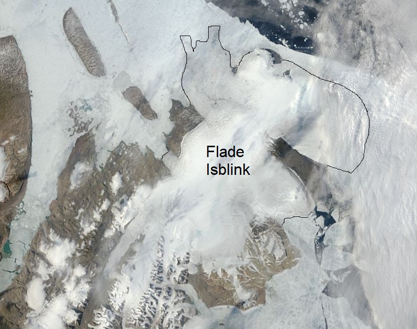
Crown Prince Christian Land extends 100 km NE from Cape Jungersen. It is a largely glaciated peninsula surrounded to the north by the Wandel Sea of the Arctic Ocean, to the east by Fram Strait, to the south by the Ingolf Fjord and the Greenland Sea, with Antarctic Bay, and to the west by the Greenland Ice Sheet. The northern section of the peninsula is known as Erik S. Henius Land. In the northwest the smaller Princess Ingeborg Peninsula consists mostly of lowland. The southeastern part is mountainous and is known as Amdrup Land. The outer part of Crown Prince Christian Land is almost totally covered by the Flade Isblink ice cap.

Sections adapted from Wikipedia: Crown Prince Christian Land (CC BY-SA 4.0).

Peary Land
Image via Wikimedia Commons (author and licence on the file page).

Peary Land

Geoarea · 161 km²

Peary Land is a geoarea in North America (Greenland), covering an estimated 161 km².

Peary Land is a peninsula in northern Greenland, extending into the Arctic Ocean. It reaches from Victoria Fjord in the west to Independence Fjord in the south and southeast, and to the Arctic Ocean in the north, with Cape Morris Jesup, the northernmost point of Greenland's mainland, and Cape Bridgman in the northeast.

Adapted from Wikipedia: Peary Land (CC BY-SA 4.0).

Feature class
Geoarea
Mapped extent
161 km²
Size rank
#207 of 231 landforms
Region
North America
Subregion
Greenland
Coordinates
83.3707°, -24.2412°
Summits:
Newtontoppen (1,713 m), Beerenberg (2,277 m), Gunnbjørn Fjeld (3,694 m)
Ranges:
Ural Mountains (Europe), Brooks Range (North America)
Settlements:
Tromsø (1,797 km), Narvik (1,912 km), Bodø (2,005 km)

View on the live map

More about Peary Land

Geography

Peary Land is bounded by the Lincoln Sea (west of Cape Morris Jesup) and Wandel Sea of the Arctic Ocean in the north. Oodaaq island, the northernmost point of land of the world, lies off the north coast. Frederick E. Hyde Fjord, which cuts into Peary Land from the east 150 kilometres (93 mi) deep, divides it into Northern Peary Land and Southern Peary Land. Cape Eiler Rasmussen is the easternmost point. The coastline is deeply indented by smaller fjords, such as G.B. Schley Fjord and Hellefisk Fjord in the east, and Sands Fjord, Benedict Fjord, J.P. Koch Fjord, De Long Fjord and Weyprecht Fjord in the west. Børglum River, the largest river in Greenland, is located in Peary Land.

Peary Land is not part of any municipality but belongs to the Northeast Greenland National Park.

History

Peary Land was historically inhabited by three separate cultures, during which times the climate was milder than presently. It contains the northernmost ruins on earth, an archaeological site found in 2023.

The area is named after Robert E. Peary, who first explored it during his expedition of 1891 to 1892. Originally, Peary Land was believed to be an island, separated from the main island by the so-called Peary Channel, an assumed connection between Nordenskiöld Fjord and Independence Fjord which in fact does not exist. Ludvig Mylius-Erichsen (1872–1907), the ill-fated leader of the Denmark expedition, searched in vain for the Peary Channel in 1907 and was misled to his death by existing maps. Knud Rasmussen's First Thule Expedition confirmed in 1912 that Peary Land is a peninsula.

Sections adapted from Wikipedia: Peary Land (CC BY-SA 4.0).

Peary Land: Key Facts

Key facts about Peary Land
OnVictoria Fjord

Facts from Wikidata Q1484427 (CC0).

Nyeboe Land

Geoarea · 28 km²

Nyeboe Land is a geoarea in North America (Greenland), covering an estimated 28 km².

Nyeboe Land (Danish: Nyeboes Land) is a peninsula in far northwestern Greenland. It is a part of the Northeast Greenland National Park.

Adapted from Wikipedia: Nyeboe Land (CC BY-SA 4.0).

Feature class
Geoarea
Mapped extent
28 km²
Size rank
#224 of 231 landforms
Region
North America
Subregion
Greenland
Coordinates
82.3420°, -54.7381°
Summits:
Newtontoppen (1,713 m), Gunnbjørn Fjeld (3,694 m), Beerenberg (2,277 m)
Ranges:
Brooks Range (North America), Ogilvie Mountains (North America)
Settlements:
Tromsø (2,178 km), Reykjavík (2,204 km), Narvik (2,282 km)

View on the live map

More about Nyeboe Land

Geography

Nyeboe Land is located to the northeast of Hall Land in the west, and southwest of Hendrik Island and west of Warming Land and the Steensby Glacier in the east. It is bounded to the north by the Lincoln Sea and to the east by Saint George Fjord. Newman Fjord (Newman Bay) marks the western limit of Nyeboe Land. To the south and southeast the peninsula is attached to the mainland and its ice cap. The Dreyer Firn is located in the southwest, near the Saint George Fjord's shore. There are three small bays in the northern shore, Repulse Harbour, Hand Bay and Frankfield Bay, from west to east.

Nyeboe Land is largely unglaciated and mountainous. 1,100 metres (3,609 ft) high Punch Mountain, the highest elevation of the peninsula, is located at the northern end.

Sections adapted from Wikipedia: Nyeboe Land (CC BY-SA 4.0).

Jameson Land
Image via Wikimedia Commons (author and licence on the file page).

Jameson Land

Geoarea

Jameson Land is a geoarea in North America (Greenland).

Jameson Land is a peninsula in eastern Greenland. The peninsula is located north of Scoresby Sound, opposite of King Christian IX Land. Administratively it falls within Sermersooq municipality.

Adapted from Wikipedia: Jameson Land (CC BY-SA 4.0).

Feature class
Geoarea
Region
North America
Subregion
Greenland
Coordinates
70.4145°, -23.6000°
Summits:
Gunnbjørn Fjeld (3,694 m), Beerenberg (2,277 m), Mount Forel (3,360 m)
Ranges:
Grampian Mountains (Europe), Cambrian Mountains (Europe)
Settlements:
Reykjavík (700 km), Bodø (1,538 km), Ålesund (1,567 km)

View on the live map

More about Jameson Land

Geography

Jameson Land is bounded to the south by Scoresby Sound (the world's largest fjord), to the northwest by the Stauning Alps, to the north by Scoresby Land, to the northeast by the Fleming Fjord and the Nathorst Fjord of the Greenland Sea, and to the east by Carlsberg Fjord, the smaller Liverpool Land peninsula branching off, and Hurry Inlet. Its northeastern end is Cape Biot.

Jameson Land experiences a tundra climate (Köppen: ET); with short, cool summers and long, frigid winters. Temperature & humidity data within the weatherbox below was recorded from the Nerlerit Inaat Airport (2002-2020) and precipitation was sourced from Uunarteq (1958-1980).

Geology

Jameson Land mainly consists of a tilted peneplain of Jurassic sandstone, highest in the east. In the northern end there are also rocks of Triassic age. Two formations are predominant in Jameson Land: the Triassic Fleming Fjord Formation and the Jurassic Kap Stewart Formation.

Triassic fossils of the Fleming Fjord Formation in Jameson Land include: the dipnoi Ceratodus, prosauropod and theropod dinosaurs bones and tracks, sauropod tracks, phytosaurs, temnospondyls, and sharks.

Ecology

The peninsula's flora includes alpine foxtail, arctic bell-heather, arctic willow, Bigelow's sedge, bog blueberries, various types of cottongrass, dwarf birch, Kentucky bluegrass, moss campion, mountain avens, varioues sedges, slim-stem small reed grass, wideleaf polargrass and the fungus Stereocaulon alpinum.

The peninsula is home to muskoxen, who sustain themselves off mainly willows during summer and various graminoids during winter.

Sections adapted from Wikipedia: Jameson Land (CC BY-SA 4.0).

More on Greenland

Quick Answers

What is the largest landform in Greenland?
North America, at 27.05M km². Greenland Ice Sheet is second at 1.03M km². Rankings cover the mountain ranges, deserts and other landforms indexed in YearMaps.
How many mountain ranges, deserts and other landforms are there in Greenland?
YearMaps lists 14 mountain ranges, deserts and other landforms for Greenland. This is the number mapped in the atlas, not an official national count.