
UNESCO World Heritage Sites in Croatia
Croatia has 9 sites on the UNESCO World Heritage List (7 cultural and 2 natural), the first inscribed in 1979 (Historical Complex of Split with the Palace of Diocletian). The map below plots every one of them alongside the rest of the List, and each site is written up in full further down the page.
- World Heritage Sites
- 9
- Cultural
- 7
- Natural and Mixed
- 2
- First Inscribed
- 1979
Map of World Heritage Sites in Croatia
CulturalNaturalMixedIn DangerLarge dots are in Croatia. Click a dot to read about the site.

Historical Complex of Split with the Palace of Diocletian
Croatia · 43.5083° N, 16.4389° E · 3 km from Split
The ruins of Diocletian's Palace, built between the late 3rd and the early 4th centuries A.D., can be found throughout the city. The cathedral was built in the Middle Ages, reusing materials from the ancient mausoleum. Twelfth- and 13th-century Romanesque churches, medieval fortifications, 15th-century Gothic palaces and other palaces in Renaissance and Baroque style make up the rest of the protected area.
Description from the UNESCO World Heritage Centre (CC BY-SA IGO 3.0).
Why Historical Complex of Split with the Palace of Diocletian Is Listed
- (ii)
- An important interchange of human values.
- (iii)
- A unique testimony to a cultural tradition or civilisation.
- (iv)
- An outstanding example of a type of building or landscape.

Old city (Dubrovnik)
Croatia · 42.6409° N, 18.1091° E · 1 km² · 3 km from Dubrovnik
The 'Pearl of the Adriatic', situated on the Dalmatian coast, became an important Mediterranean sea power from the 13th century onwards. Although severely damaged by an earthquake in 1667, Dubrovnik managed to preserve its beautiful Gothic, Renaissance and Baroque churches, monasteries, palaces and fountains. Damaged again in the 1990s by armed conflict, it is now the focus of a major restoration programme co-ordinated by UNESCO.
Description from the UNESCO World Heritage Centre (CC BY-SA IGO 3.0).
Why Old city (Dubrovnik) Is Listed
- (i)
- A masterpiece of human creative genius.
- (iii)
- A unique testimony to a cultural tradition or civilisation.
- (iv)
- An outstanding example of a type of building or landscape.

Plitvice Lakes National Park
Croatia · 44.8805° N, 15.6160° E · 296 km² · 68 km from Karlovac
Plitvice Lakes National Park is one of the oldest and largest national parks in Croatia. In 1979, Plitvice Lakes National Park was inscribed on the UNESCO World Heritage list, for its outstanding and picturesque series of tufa lakes, caves, and connected waterfalls.
The national park was founded in 1949 and is in the mountainous karst area of central Croatia, at the border with Bosnia and Herzegovina. The important north–south road that passes through the national park area connects the Croatian inland with the Adriatic coastal region.
The protected area extends over 296.85 km2 (114.61 sq mi). About 90% of this area is part of Lika-Senj County, while the remaining 10% is part of Karlovac County.
Adapted from Wikipedia: Plitvice Lakes National Park (CC BY-SA 4.0).
Why Plitvice Lakes National Park Is Listed
- (vii)
- Superlative natural phenomena or exceptional natural beauty.
- (viii)
- An outstanding example of major stages of the Earth's history.
- (ix)
- An outstanding example of ongoing ecological and biological processes.
More about Plitvice Lakes National Park
UNESCO's Description
The waters flowing over the limestone and chalk have, over thousands of years, deposited travertine barriers, creating natural dams which in turn have created a series of beautiful lakes, caves and waterfalls. These geological processes continue today. The forests in the park are home to bears, wolves and many rare bird species.
From the UNESCO World Heritage Centre (CC BY-SA IGO 3.0).
Topography and geology
The availability of water, influenced by the configuration of the terrain, has a great impact on the biodiversity of this area. The Plitvice Lakes are surrounded by various mountains. The western side of the national park area is enclosed by the Mala Kapela mountain, while the eastern side is enclosed by the Lička Plješivica mountain, which also represents the border with Bosnia and Herzegovina. Plitvice Lakes National Park is situated in the Plitvice plateau which is surrounded by three mountains that are part of the Dinaric Alps: Lička Plješivica mountain (Gola Plješevica peak 1,640 m), Mala Kapela mountain (Seliški Vrh peak at 1,280 m), and Medveđak (884 m).
The afforested mountain slopes serve as reservoirs. They are also a refuge for many animal species.
Climate
On average, the annual precipitation rate at the Plitvice Lakes is 1,500 mm (59 in). Usually, in spring and fall (autumn) the largest rain quantities are measured. The average relative air humidity is 81.8 percent. In January, the average temperature is 2.2 °C (36 °F). During the summer months of July and August, the temperature rises to 17.4 °C (63 °F). The general average annual temperature is 7.9 °C (46 °F). Snow falls from November until March. Usually, the lakes are frozen during December and January.
History
During the 6th century, Avars settled in this region, which were accompanied by the Croats. The Croats eventually defied Avar control and settled permanently in this region. In medieval times, frequent attacks by Mongols posed a permanent threat to the settled population.
Croat rule and particularly the rule of the noble families Zrinski and Frankopan led to economic recovery in the wider area. On the remnants of an ancient settlement of the Japods and Romans a monastery was built at the lakes. Presumably, this monastery belonged to the Order of Saint Paul the First Hermit (Croatian pavlinci) or the Knights Templars. Today, only ancient wall remnants of this building (Croatian gradina) exist. The foundation was made of travertine rock.
Location
The area of Plitvice Lakes National Park extends across two political subdivisions or counties (Croatian županija). Its 296.85 km2 (114.61 sq mi) area is divided between Lika-Senj County (90.7 percent) and Karlovac County (9.3 percent), hence the national park authority is under national jurisdiction. The overall water body area is about 2 km2 (0.77 sq mi). The two largest lakes, Prošćansko jezero and Kozjak, cover about 80 percent of the overall water body area. These lakes are also the deepest, with a depth of 37 and 47 m (121 and 154 ft) respectively. None of the other lakes in the park exceed 25 m (82 ft) in depth. The elevation drop from the first lake to the last is 133 m (436 ft).
Sections adapted from Wikipedia: Plitvice Lakes National Park (CC BY-SA 4.0).
Key Facts
| Established | 8 April 1949 |
|---|---|
| Area | 297 km² |
Facts from Wikidata Q189849 (CC0).
Visiting Plitvice Lakes National Park
Plitvice Lakes National Park (Nacionalni park Plitvička jezera) in Croatia is one of the most beautiful natural sights in Europe. Due to its beauty and significance, this system of 16 interlinked lakes and a large forest complex around it were set aside as a national park in 1949. In 1979 the park was inscribed on the UNESCO world heritage list. Many Germans will recognize features of the park, as many of the Karl May Westerns were shot here.
Travel notes adapted from Wikivoyage: Plitvice Lakes National Park (CC BY-SA 4.0).

Euphrasian Basilica
Croatia · 45.2286° N, 13.5936° E · 45 km from Pula
The Euphrasian Basilica (Croatian: Eufrazijeva bazilika, Italian: Basilica Eufrasiana) or the Cathedral Basilica of the Assumption of Mary is a Roman Catholic basilica in the Istrian town of Poreč, Croatia. The episcopal complex, which comprises the basilica itself, a sacristy, a baptistery and the bell tower of the nearby archbishop's palace, is an excellent example of early Byzantine architecture in the Mediterranean region.
The Euphrasian basilica has for the most part retained its original shape, but accidents, fires and earthquakes have altered a few details. Since it is the third church to be built on the same site, it conceals previous buildings, for example the great floor mosaic of the previous basilica from the 5th century. Because of its exceptional value, it has been inscribed on the UNESCO World Heritage List since 1997. The basilica is also the cathedral of the Roman Catholic Diocese of Poreč-Pula. It is considered the best preserved early-christian church in the world.
Adapted from Wikipedia: Euphrasian Basilica (CC BY-SA 4.0).
Why Euphrasian Basilica Is Listed
- (ii)
- An important interchange of human values.
- (iii)
- A unique testimony to a cultural tradition or civilisation.
- (iv)
- An outstanding example of a type of building or landscape.
More about Euphrasian Basilica
UNESCO's Description
The group of religious monuments in Porec, where Christianity was established as early as the 4th century, constitutes the most complete surviving complex of its type. The basilica, atrium, baptistery and episcopal palace are outstanding examples of religious architecture, while the basilica itself combines classical and Byzantine elements in an exceptional manner.
From the UNESCO World Heritage Centre (CC BY-SA IGO 3.0).
History
The earliest basilica was dedicated to Saint Maurus of Parentium and dates back to the second half of the 4th century. The floor mosaic from its oratory, originally part of a large Roman house, is still preserved in the church garden. This oratorium was already expanded in the same century into a church composed of a nave and one aisle (basilicae geminae). The fish on the floor mosaic dates from this period. Coins with the portrayal of emperor Valens (365–378), found in the same spot, confirm these dates.
The present basilica, dedicated to Mary, was built in the sixth century during the period of Bishop Euphrasius. It was built from 553 on the site of the older basilica that had become dilapidated.
Description
A 6th-century octagonal baptistry built in the 5th century together with the pre-Euphrasian basilica, which has undergone considerable alterations.
A colonnaded atrium. Built after the basilica, it is covered on all four sides by a portico which houses a rich collection of stone monuments.
An Episcopal residence (The Bishop's Palace), also built in the 6th century. with very little remaining of the original building.
A trefoil-shaped memorial chapel, built in the 17th and 19th centuries.
The two aisles are separated from the nave by 18 elegant Greek marble colonnades with richly sculpted Byzantine and Romanesque capitals, decorated with depictions of animals. They all carry the monogram of Saint Euphrasius. The arches between the capitals are decorated with stucco work.
Sections adapted from Wikipedia: Euphrasian Basilica (CC BY-SA 4.0).
Key Facts
| Established | 553 CE |
|---|---|
| Area | 0 km² |
| Architectural style | Byzantine architecture |
Facts from Wikidata Q645105 (CC0).

Historic City of Trogir
Croatia · 43.5125° N, 16.2517° E · 18 km from Split
Trogir is a remarkable example of urban continuity. The orthogonal street plan of this island settlement dates back to the Hellenistic period and it was embellished by successive rulers with many fine public and domestic buildings and fortifications. Its beautiful Romanesque churches are complemented by the outstanding Renaissance and Baroque buildings from the Venetian period.
Description from the UNESCO World Heritage Centre (CC BY-SA IGO 3.0).
Why Historic City of Trogir Is Listed
- (ii)
- An important interchange of human values.
- (iv)
- An outstanding example of a type of building or landscape.

Šibenik Cathedral
Croatia · 43.7356° N, 15.8892° E · 2 km from Šibenik
The Cathedral of St. James (Croatian: Katedrala sv. Jakova) or simply Šibenik Cathedral is a triple-nave Catholic cathedral with three apses and a dome (32 m high inside) in Šibenik, Croatia. It is the episcopal seat of the Diocese of Šibenik. It is often known as "St. Jacob's", because Croatian, like many other languages, uses the same name for both "James" and "Jacob". It is dedicated to Saint James the Great.
It was built entirely from stone between 1431 and 1536, the cathedral was designed by several prominent architects, most notably Juraj Dalmatinac and Nikola Firentinac, whose innovative construction techniques shaped its unique appearance. The cathedral is famous for its monumental stone dome, richly decorated portals, and the remarkable frieze of carved human heads surrounding the apses, which are considered to be individual portraits of people from Dalmatia at the time.
It is the most important architectural monument of the Renaissance in the entire country, and one of the finest examples of Gothic and Renaissance architecture on the Adriatic coast. Because of its exceptional cultural, historical, and artistic significance, the Cathedral of St.
Adapted from Wikipedia: Šibenik Cathedral (CC BY-SA 4.0).
Why Šibenik Cathedral Is Listed
- (i)
- A masterpiece of human creative genius.
- (ii)
- An important interchange of human values.
- (iv)
- An outstanding example of a type of building or landscape.
More about Šibenik Cathedral
UNESCO's Description
The Cathedral of St James in Šibenik (1431-1535), on the Dalmatian coast, bears witness to the considerable exchanges in the field of monumental arts between Northern Italy, Dalmatia and Tuscany in the 15th and 16th centuries. The three architects who succeeded one another in the construction of the Cathedral - Francesco di Giacomo, Georgius Mathei Dalmaticus and Niccolò di Giovanni Fiorentino - developed a structure built entirely from stone and using unique construction techniques for the vaulting and the dome of the Cathedral. The form and the decorative elements of the Cathedral, such as a remarkable frieze decorated with 71 sculptured faces of men, women, and children, also illustrate the successful fusion of Gothic and Renaissance art.
From the UNESCO World Heritage Centre (CC BY-SA IGO 3.0).
History
Šibenik was first mentioned in written records in 1066, in a document issued by the Croatian king Petar Krešimir IV, who ruled from 1058 to 1074. Unlike most major coastal cities in Croatia, Šibenik was not founded during ancient times, but emerged nearly a thousand years later.
The 13th century marked a turning point in the city’s history. During this period, Šibenik fought to rise from the status of a villa - a settlement or town, to that of a civitas, meaning a fully recognized city with political independence and freedoms already enjoyed by neighboring urban centers. An important step forward came in 1251, when King Bela IV confirmed a charter granting the town broad autonomy. However, complete recognition also required ecclesiastical independence.
Sections adapted from Wikipedia: Šibenik Cathedral (CC BY-SA 4.0).
Key Facts
| Established | 1431 |
|---|---|
| Area | 0 km² |
| Architectural style | Renaissance architecture |
Facts from Wikidata Q391973 (CC0).

Stari Grad Plain
Croatia · 43.1817° N, 16.6386° E · 14 km² · 40 km from Split
The Stari Grad Plain, near the town of Stari Grad on the island of Hvar, Croatia, is an agricultural landscape that was set up by the ancient Greek colonists in the 4th century BC, and remains in use to this day. The plain is the largest agricultural area on any of the Adriatic islands and is remarkably fertile due to Ice Age loess deposition.
This landscape is almost entirely preserved from its original form. The ancient layout has been preserved by careful maintenance of the stone walls over 24 centuries, along with the stone shelters (known locally as trims), and the water collection system. The same crops, mainly grapes and olives, are still grown in the fields, and the site is also a natural reserve. The site is a valuable example of the ancient Greek system of agriculture, and was inscribed as a UNESCO World Heritage Site in 2008.
Adapted from Wikipedia: Stari Grad Plain (CC BY-SA 4.0).
Why Stari Grad Plain Is Listed
- (ii)
- An important interchange of human values.
- (iii)
- A unique testimony to a cultural tradition or civilisation.
- (v)
- An outstanding example of traditional human settlement or land use.
More about Stari Grad Plain
UNESCO's Description
Stari Grad Plain on the Adriatic island of Hvar is a cultural landscape that has remained practically intact since it was first colonized by Ionian Greeks from Paros in the 4th century BC. The original agricultural activity of this fertile plain, mainly centring on grapes and olives, has been maintained since Greek times to the present. The site is also a natural reserve. The landscape features ancient stone walls and trims, or small stone shelters, and bears testimony to the ancient geometrical system of land division used by the ancient Greeks, the chora which has remained virtually intact over 24 centuries.
From the UNESCO World Heritage Centre (CC BY-SA IGO 3.0).
History
In 384 BC, Stari Grad was colonized by Greeks from the island of Paros. The colonists divided the plain into 75 land parcels (called chora), each measuring roughly 16 hectares, bordered by dry stone walls. These walls may have been secondarily used to surveil the plain or to travel quickly across the landscape. The original field layout has been respected by the continuous maintenance of the boundary walls by succeeding generations. Agricultural activity in the chora has been uninterrupted for 24 centuries up to the present day. What we see today is a continuation of the cultural landscape of the original Greek colonists.
In addition to the chora, the Greeks built small store huts made of dry stone called trims, where tools were kept and people could take refuge from bad weather.
Sections adapted from Wikipedia: Stari Grad Plain (CC BY-SA 4.0).
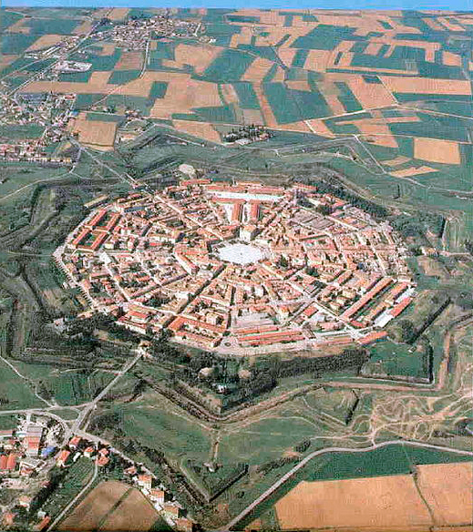
The Venetian Works of defence between 15th and 17th centuries
Croatia, Italy, Montenegro · 45.7033° N, 9.6636° E · 4 km² · 1 km from Bergamo
Venetian Works of Defence between the 16th and 17th Centuries: Stato da Terra – Western Stato da Mar is a UNESCO World Heritage Site comprising six bastion forts constructed by the Republic of Venice in its mainland territories (Stato da Terra) and maritime domains (Stato da Mar).
With the increase in firearm warfare in the early modern period of gunpowder when the cannon came to dominate the battlefield, came significant shifts in military strategy and fort design. One of these changes was the development of the bastion fort, or alla moderna fortifications, with a polygon-shaped fortress with bulwarks at the corners. These designs originated from the Republic of Venice, but would soon spread throughout Europe and remain the standard for defence until the 19th century. In 2017, six of these fortifications in Italy, Croatia, and Montenegro were inscribed on the UNESCO World Heritage list. These six sites provide quintessential examples of this fort design, demonstrate the influence of Renaissance-era Venice, and pay testimony to a major advancement in the history of warfare.
Adapted from Wikipedia: Venetian Works of Defence between the 16th and 17th centuries: Stato da Terra – Western Stato da Mar (CC BY-SA 4.0).
Why The Venetian Works of defence between 15th and 17th centuries Is Listed
- (iii)
- A unique testimony to a cultural tradition or civilisation.
- (iv)
- An outstanding example of a type of building or landscape.
More about The Venetian Works of defence between 15th and 17th centuries
UNESCO's Description
This property consists of 6 components of defence works in Italy, Croatia and Montenegro, spanning more than 1,000 km between the Lombard region of Italy and the eastern Adriatic Coast. The fortifications throughout the Stato da Terra protected the Republic of Venice from other European powers to the northwest and those of the Stato da Mar protected the sea routes and ports in the Adriatic Sea to the Levant. They were necessary to support the expansion and authority of the Serenissima . The introduction of gunpowder led to significant shifts in military techniques and architecture that are reflected in the design of so-called alla moderna / bastioned, fortifications, which were to spread throughout Europe.
From the UNESCO World Heritage Centre (CC BY-SA IGO 3.0).
Shared With Neighbouring Countries
These sites cross the border. Each is written up on the page of the country UNESCO lists first.

World Heritage in Croatia: Quick Answers
- How many UNESCO World Heritage Sites are in Croatia?
- Croatia has 9 World Heritage Sites: 7 cultural and 2 natural. 1 of them is shared with a neighbouring country.
- What was the first World Heritage Site in Croatia?
- Historical Complex of Split with the Palace of Diocletian, inscribed in 1979. The most recent is The Venetian Works of defence between 15th and 17th centuries, inscribed in 2017.
- What are the natural World Heritage Sites in Croatia?
- Plitvice Lakes National Park, Ancient and Primeval Beech Forests of the Carpathians and Other Regions of Europe.
- Are any World Heritage Sites in Croatia in danger?
- None of the World Heritage Sites in Croatia is on UNESCO's List of World Heritage in Danger.