
UNESCO World Heritage Sites in Denmark
Denmark has 13 sites on the UNESCO World Heritage List (8 cultural and 5 natural), the first inscribed in 1994 (Jelling Heritage Site). The map below plots every one of them alongside the rest of the List, and each site is written up in full further down the page.
- World Heritage Sites
- 13
- Cultural
- 8
- Natural and Mixed
- 5
- First Inscribed
- 1994
Map of World Heritage Sites in Denmark
CulturalNaturalMixedIn DangerLarge dots are in Denmark. Click a dot to read about the site.

Jelling Heritage Site
Denmark · 55.7565° N, 9.4197° E · 9 km from Vejle
The Jelling burial mounds and one of the runic stones are striking examples of pagan Nordic culture, while the other runic stone and the church illustrate the Christianization of the Danish people towards the middle of the 10th century.
Description from the UNESCO World Heritage Centre (CC BY-SA IGO 3.0).
Why Jelling Heritage Site Is Listed
- (iii)
- A unique testimony to a cultural tradition or civilisation.

Roskilde Cathedral
Denmark · 55.6427° N, 12.0803° E · 1 km from Roskilde
Roskilde Cathedral (Danish: Roskilde Domkirke), in the city of Roskilde on the island of Zealand (Sjælland) in eastern Denmark, is a cathedral of the Lutheran Church of Denmark.
The cathedral is one of the most important churches in Denmark, and the official royal burial church of the Danish monarchs. It is also a UNESCO World Heritage Site. This is due to two criteria: the architecture of the cathedral shows 800 years of European architectural styles, and it is one of the earliest examples in Scandinavia of a Gothic cathedral to be built in brick; it encouraged the spread of the Brick Gothic style throughout Northern Europe. Constructed during the 12th and 13th centuries, the cathedral incorporates both Gothic and Romanesque architectural features in its design. The cathedral has been the main burial site for Danish monarchs since the 15th century. As such, it has been significantly extended and altered over the centuries to accommodate a considerable number of burial chapels and the many added chapels show different architectural styles.
The cathedral is a major tourist attraction, bringing in over 165,000 visitors annually.
Adapted from Wikipedia: Roskilde Cathedral (CC BY-SA 4.0).
Why Roskilde Cathedral Is Listed
- (ii)
- An important interchange of human values.
- (iv)
- An outstanding example of a type of building or landscape.
More about Roskilde Cathedral
UNESCO's Description
Built in the 12th and 13th centuries, this was Scandinavia's first Gothic cathedral to be built of brick and it encouraged the spread of this style throughout northern Europe. It has been the mausoleum of the Danish royal family since the 15th century. Porches and side chapels were added up to the end of the 19th century. Thus it provides a clear overview of the development of European religious architecture.
From the UNESCO World Heritage Centre (CC BY-SA IGO 3.0).
History
Roskilde was named the new capital of Denmark by King Harald Bluetooth around the year 960. The King had previously resided in Jelling, where he built a church and raised the Jelling stones, but after uniting the Danes and Norwegians, a move was necessary to enable the monarch to stay close to the centre of power in the new kingdom. According to written sources, when moving to Roskilde, Bluetooth built a royal farm and next to it, a small stave church, dedicated to the Holy Trinity. Little is known of the Trinity Church, let alone its architecture, but despite its brief history at least two events are known to have taken place.
Description
When King Christopher III died childless in 1448, his widow Dorothea of Brandenburg remarried the newly chosen king, Christian I. Within a few years, he became king of Denmark, Norway, and Sweden, and Dorothea had given birth to the future king John, thus establishing the House of Oldenburg. Against this background of events, the Christian I decided to build a grand chapel at the cathedral. The instrument of foundation was signed on 28 April 1459, which not only ordered the construction of the chapel but also granted large tracts of land to the church. In the spring of 1462, the king applied to Pope Pius II for indulgence for having constructed the chapel, which was finally granted upon his visit to Pope Sixtus IV in Rome in 1474.
Sections adapted from Wikipedia: Roskilde Cathedral (CC BY-SA 4.0).
Key Facts
| Established | 13th century |
|---|---|
| Area | 0 km² |
| Architectural style | Brick Gothic |
Facts from Wikidata Q209705 (CC0).

Kronborg Castle
Denmark · 56.0386° N, 12.6219° E · 5 km from Helsingborg
Kronborg (Danish pronunciation: [ˈkʰʁoːnˌpɒˀ]) is a castle and historical stronghold in the town of Helsingør, Denmark. Immortalised as Elsinore in William Shakespeare's play Hamlet, Kronborg is one of the most important Renaissance castles in Northern Europe. It was inscribed on the UNESCO World Heritage List in 2000.
The castle is situated on the extreme northeastern tip of the island of Zealand at the narrowest point of the Øresund, the sound between present Denmark and the provinces of present Sweden. The latter were under Danish control at the time the castle was built. In this part, the sound is only 4 kilometres (2.5 mi) wide, hence the strategic importance of maintaining a coastal fortification at this location commanding one of the few outlets of the Baltic Sea.
The castle's story dates back to a stronghold, Krogen, built by King Eric VII in the 1420s. Along with the fortress Kärnan in Helsingborg, on the opposite coast of Øresund, it controlled the entrance to the Baltic Sea. From 1574 to 1585, King Frederick II had the medieval fortress radically transformed into a magnificent Renaissance castle.
Adapted from Wikipedia: Kronborg (CC BY-SA 4.0).
Why Kronborg Castle Is Listed
- (iv)
- An outstanding example of a type of building or landscape.
More about Kronborg Castle
UNESCO's Description
Located on a strategically important site commanding the Sund, the stretch of water between Denmark and Sweden, the Royal castle of Kronborg at Helsingør (Elsinore) is of immense symbolic value to the Danish people and played a key role in the history of northern Europe in the 16th-18th centuries. Work began on the construction of this outstanding Renaissance castle in 1574, and its defences were reinforced according to the canons of the period's military architecture in the late 17th century. It has remained intact to the present day. It is world-renowned as Elsinore, the setting of Shakespeare's Hamlet.
From the UNESCO World Heritage Centre (CC BY-SA IGO 3.0).
History
The castle's history dates to a fortress, Krogen (lit. 'the Hook'), built in the early 15th century by the Danish king, Eric of Pomerania. The king insisted on payment of sound dues by all ships wishing to enter or leave the Baltic Sea through the Øresund; to help enforce his demands, he built a powerful fortress at the narrowest point in the Sound. At the time, the Kingdom of Denmark extended across both sides of the Sound. On the eastern shore the Helsingborg Castle had been operating since the Middle Ages. With the two castles and guard ship, Denmark could control all navigation through the Sound.
The castle was built on Ørekrog, a sandy tongue of land stretching into the sea from the coast of Zealand toward the coast of Scania.
Sections adapted from Wikipedia: Kronborg (CC BY-SA 4.0).

Ilulissat Icefjord
Denmark · 69.1500° N, 49.5500° W · 3,998 km²
Ilulissat Icefjord (Greenlandic: Ilulissat Kangerlua) is a fjord in western Greenland. Located 250 km north of the Arctic Circle, the Ilulissat Icefjord runs west 40 km (25 mi) from the Greenland ice sheet to Disko Bay just south of the town of Ilulissat. Ilulissat Icefjord was declared a UNESCO World Heritage Site in 2004 because of its natural beauty and the importance of the fast-moving Jacobshavn Glacier in developing the current scientific understanding of anthropogenic climate change.
Adapted from Wikipedia: Ilulissat Icefjord (CC BY-SA 4.0).
Why Ilulissat Icefjord Is Listed
- (vii)
- Superlative natural phenomena or exceptional natural beauty.
- (viii)
- An outstanding example of major stages of the Earth's history.
More about Ilulissat Icefjord
UNESCO's Description
Located on the west coast of Greenland, 250 km north of the Arctic Circle, Greenland’s Ilulissat Icefjord is the sea mouth of Sermeq Kujalleq, one of the few glaciers through which the Greenland ice cap reaches the sea. Sermeq Kujalleq is one of the fastest and most active glaciers in the world. It annually calves over 35 km3 of ice, i.e. 10% of the production of all Greenland calf ice and more than any other glacier outside Antarctica. Studied for over 250 years, it has helped to develop our understanding of climate change and icecap glaciology. The combination of a huge ice-sheet and the dramatic sounds of a fast-moving glacial ice-stream calving into a fjord covered by icebergs makes for a dramatic and awe-inspiring natural phenomenon.
From the UNESCO World Heritage Centre (CC BY-SA IGO 3.0).
Geography
The fjord contains the Jacobshavn Isbræ (Greenlandic: Sermeq Kujalleq), the most productive glacier in the Northern Hemisphere. The glacier flows at a rate of 20–35 m (66–115 ft) per day, resulting in around 20 billion tonnes of icebergs calved off and passing out of the fjord every year. The ice from the fjord extends to about 250,000 years in age, making it a feature of attention for studying past climatology.
Icebergs breaking from the glacier are often so large —up to a kilometer (3,300 ft) in height— that they are too tall to float down the fjord and lie stuck on the bottom of its shallower areas, sometimes for years, until they are broken up by the force of the glacier and icebergs further up the fjord.
Sections adapted from Wikipedia: Ilulissat Icefjord (CC BY-SA 4.0).
Key Facts
| Established | 2003 |
|---|---|
| Area | 4,024 km² |
Facts from Wikidata Q828071 (CC0).

Stevns Klint
Denmark · 55.2822° N, 12.4500° E · 1 km² · 45 km from København
Stevns Klint, known as the Cliffs of Stevns in English, is a white chalk cliff located some 6 km (3.7 mi) southeast of Store Heddinge on the Danish island of Zealand. Stretching 17 km (11 mi) along the coast, it is of geological importance as one of the best exposed Cretaceous-Tertiary (K/T) boundaries in the world. Subject to frequent erosion, the cliff rises to a height of up to 40 m (130 ft). Because of its exceptional fossil record, Stevns Klint was inscribed on the UNESCO World Heritage List in 2014.
Adapted from Wikipedia: Stevns Klint (CC BY-SA 4.0).
Why Stevns Klint Is Listed
- (viii)
- An outstanding example of major stages of the Earth's history.
More about Stevns Klint
UNESCO's Description
This geological site comprises a 15 km-long fossil-rich coastal cliff, offering exceptional evidence of the impact of the Chicxulub meteorite that crashed into the planet at the end of the Cretaceous, about 65 million years ago. Researchers think that this caused the most remarkable mass extinction ever, responsible for the disappearance of over 50 per cent of all life on Earth. The site harbours a record of the cloud of ash formed by the impact of the meteorite – the exact site being at the bottom of the ocean off the coast of Mexico’s Yucatán Peninsula. An exceptional fossil record is visible at the site, showing the complete succession of fauna and micro-fauna charting the recovery after the mass extinction.
From the UNESCO World Heritage Centre (CC BY-SA IGO 3.0).
Geology
The cliff reveals sections from the uppermost part of the Maastrichtian stage (72 to 66 million years ago), known as the Tor Formation and from the lowermost part of the Danian stage (66 to 62 million years ago); the Danian-aged rocks are known as the Rødvig Formation and the Stevns Klint Formation. The lower strata from the cliff are from the Cretaceous and are composed of soft chalk, indicating a relatively deep marine depositional environment. The dark layer of fiskeler, mainly five to ten centimeters thick, clearly marks the Cretaceous–Paleogene boundary. The fiskeler is enriched in iridium, a fact used as an argument for the Alvarez hypothesis that the worldwide Cretaceous–Paleogene mass extinction was caused by the impact of an asteroid.
Sections adapted from Wikipedia: Stevns Klint (CC BY-SA 4.0).

Christiansfeld
Denmark · 55.3567° N, 9.4831° E · 39 km from Vejle
Christiansfeld, with a population of 3,105 (1 January 2026), is a town in Kolding Municipality in Southern Jutland in Region of Southern Denmark. The town was founded in 1773 by the Moravian Church and named after the Danish king Christian VII. Since July 2015 it has been a UNESCO World Heritage Site, highlighting its status as the best-preserved example of the town-planning and architecture of the Moravian Church.
Adapted from Wikipedia: Christiansfeld (CC BY-SA 4.0).
Why Christiansfeld Is Listed
- (iii)
- A unique testimony to a cultural tradition or civilisation.
- (iv)
- An outstanding example of a type of building or landscape.
More about Christiansfeld
UNESCO's Description
This transnational serial property comprises four congregational settlements in four countries representing the transnational scope and consistency of the international Moravian community as a global network of the Moravian Church: Christiansfeld (Denmark), Herrnhut (Germany), Gracehill (United Kingdom of Great Britain and Northern Ireland) and Bethlehem (United States of America). These settlements were established according to overarching planning principles that reflected the ideals of the Moravian Church, as expressed in their plans and democratic organisation. Each architectural ensemble bears witness to the Moravian Church’s vision of a unified, coherent urban design, inspired by the concept of an “ideal city” developed by the Church during its formative phase in the 18th and beginning of the 19th enturies. Distinctive Moravian buildings include a particular type of Gemeinhaus (congregation building), church, choir houses, as well as a nearby God’s Acre (cemetery). Each settlement has its own architectural character based on an original Moravian Church Civic Baroque style but adapted to local conditions. Present today in each component part is an active congregation whose continuation of traditions forms a living Moravian heritage.
From the UNESCO World Heritage Centre (CC BY-SA IGO 3.0).
History
Most of Christiansfeld was constructed in the years 1773–1800, following a strict city plan that drew inspiration from the earlier Moravian settlements of Herrnhaag and Gnadau. To encourage construction, king Christian VII promised a ten-year tax holiday for the city and paid 10% of the construction costs of new houses. By 1779, the town's population reached 279, and by 1782, it had about 400 residents. It was one of many towns in Schleswig officially designated a small market town (flække).
In 1864, Christiansfeld and the rest of Schleswig was ceded to Prussia as a result of Denmark's defeat in the Second Schleswig War. It remained a part of Germany until 1920 when, as a part of a plebiscite called for by the Treaty of Versailles, Northern Schleswig voted to rejoin Denmark.
Description
The town was constructed around a central Church Square bordered by two parallel streets running east to west. The Hall, Sister's House, fire-house, the vicarage, and the former provost’s house were built directly around the square, and shops, Brother's House, family residences, a hotel, and a school were built along the parallel streets. Many of the residential buildings are communal, which were typical of Moravian settlements and were used by the widows and unmarried women and men of the congregation. The architecture of Christiansfeld is homogeneous, dominated by one or two-story buildings made out of yellow brick and red tile roofs. Many of the buildings in Christiansfeld retain their original uses.
Sections adapted from Wikipedia: Christiansfeld (CC BY-SA 4.0).
Key Facts
| Established | 1773 |
|---|---|
| Area | 0.2 km² |
Facts from Wikidata Q3197288 (CC0).
Visiting Christiansfeld
Kolding is a city of 62,000 people (2020) in eastern South Jutland. Visitors come to Kolding to see the 13th century royal castle of Koldinghus, the stone Church of Saint Nicholas, the Trapholt art museum and the gardens Geografisk Have.
Travel notes adapted from Wikivoyage: Kolding (CC BY-SA 4.0).

Par force hunting landscape in North Zealand
Denmark · 55.9136° N, 12.3578° E · 45 km² · 3 km from Hillerød
The Par force hunting landscape in North Zealand is a collection of hunting grounds and forests north of Copenhagen. The landscape was submitted for admission to the UNESCO List of World Heritage Sites on 1 August 2010 and was inscribed on 4 July 2015. The landscape comprises three main areas: Store Dyrehave, Gribskov and Jægersborg Dyrehave/Jægersborg Hegn, and contains the most significant hunting grounds for the medieval nobility in Denmark. The central-star grid design of the landscape, with numbered roads and stone posts, fences, demonstrates the unique planning and design of hunting landscapes in the 17th and 18th centuries.
Adapted from Wikipedia: Par force hunting landscape in North Zealand (CC BY-SA 4.0).
Why Par force hunting landscape in North Zealand Is Listed
- (ii)
- An important interchange of human values.
- (iv)
- An outstanding example of a type of building or landscape.
More about Par force hunting landscape in North Zealand
UNESCO's Description
Located about 30 km northeast of Copenhagen, this cultural landscape encompasses the two hunting forests of Store Dyrehave and Gribskov, as well as the hunting park of Jægersborg Hegn/Jægersborg Dyrehave. This is a designed landscape where Danish kings and their court practiced par force hunting, or hunting with hounds, which reached its peak between the 17th and the late 18th centuries, when the absloute monarchs transformed it into a landscape of power. With hunting lanes laid out in a star system, combined with an orthogonal grid pattern, numbered stone posts, fences and a hunting lodge, the site demonstrates the application of Baroque landscaping principles to forested areas.
From the UNESCO World Heritage Centre (CC BY-SA IGO 3.0).
Background
The forests and related buildings in three locations to the north of Copenhagen formed parts of a well-preserved Baroque hunting landscape designed in the late 17th and early 18th centuries for the Danish monarchs to participate in par force hunting. The history of the area for hunting dates back to the Middle Ages when the Danish kings, the church and noblemen had estates and hunting grounds in the peninsula's hilly forests and undulating farmlands. In connection with the Danish Reformation, in 1536 King Frederick II confiscated the estates belonging to the Catholic Church. From 1560, the various estates were merged in order to establish an extensive royal hunting park across the North Zealand peninsula.
Sections adapted from Wikipedia: Par force hunting landscape in North Zealand (CC BY-SA 4.0).
Key Facts
| Area | 45.4 km² |
|---|
Facts from Wikidata Q10620357 (CC0).

Kujataa
Denmark · 61.1644° N, 45.5981° W
Kujataa is a sub-arctic farming landscape in Kujalleq, Greenland. It is the first known example of agriculture in the Arctic, and the oldest evidence of the Old Norse culture spreading outside Europe. The unique juxtaposition of farming, hunting, and fishing that occurred in the region from the 10th through 15th centuries and from the 18th century to today headlined the region's inscription on the UNESCO World Heritage List in 2017 as Kujataa Greenland: Norse and Inuit Farming at the Edge of the Ice Cap.
Adapted from Wikipedia: Kujataa (CC BY-SA 4.0).
Why Kujataa Is Listed
- (v)
- An outstanding example of traditional human settlement or land use.
More about Kujataa
UNESCO's Description
Kujataa is a subarctic farming landscape located in the southern region of Greenland. It bears witness to the cultural histories of the Norse farmer-hunters who started arriving from Iceland in the 10th century and of the Inuit hunters and Inuit farming communities that developed from the end of the 18th century. Despite their differences, the two cultures, European Norse and Inuit, created a cultural landscape based on farming, grazing and marine mammal hunting. The landscape represents the earliest introduction of farming to the Arctic, and the Norse expansion of settlement beyond Europe.
From the UNESCO World Heritage Centre (CC BY-SA IGO 3.0).
History
The earliest known archeological remains from Kujataa date from the 3rd millennium BC, beginning with the Arctic small tool tradition and continuing with the Saqqaq and Dorset cultures, before vanishing from southern Greenland. In the 10th century, the Norse people began to arrive in southern Greenland, led by Erik the Red. Finding deep fjords suitable for agriculture in the Kujataa region, they quickly established small farming settlements, naming the area Eystribyggð (Eastern Settlement). However, the Norse farming practices on Greenland differed from those elsewhere with a greater emphasis on hunting than cereal production (possibly due to the abundance of walruses and seals in the region) and raising goats rather than sheep.
Description
Qassiarsuk: Contains Brattahlíð, the estate of Erik the Red and (possibly) the first church in the Americas.
Igaliku: Contains Garðar, which was the seat of the bishopric in Greenland, as well as the location of the first modern Inuit farm in Greenland.
Sissarluttoq: Contains a particularly large Norse manor house, with the remains of over 40 structures.
Tasikuluulik (Vatnahverfi): Contains Greenland's longest rural road, which connects multiple Inuit sheep farms.
Qaqortukulooq (Hvalsey): Contains 11 Norse and 2 Thule sites, including the best preserved Norse ruin in Greenland and the site of the last recorded mention of Europeans in Greenland in 1408.
Sections adapted from Wikipedia: Kujataa (CC BY-SA 4.0).

Aasivissuit–Nipisat
Denmark · 67.0639° N, 51.4332° W · 4,178 km²
Aasivissuit – Nipisat: Inuit Hunting Ground between Ice and Sea is a cultural landscape and UNESCO World Heritage Site located in the central part of Western Greenland. Added to the World Heritage List in 2018, the site preserves the archeological remains of over 4000 years of occupation and contains well-preserved evidence of seasonal hunting and gathering. Remains from the Saqqaq, Dorset, and Thule cultures and sites from the later Inuit and colonial era are protected within the site.
Adapted from Wikipedia: Aasivissuit – Nipisat: Inuit Hunting Ground between Ice and Sea (CC BY-SA 4.0).
Why Aasivissuit–Nipisat Is Listed
- (v)
- An outstanding example of traditional human settlement or land use.
More about Aasivissuit–Nipisat
UNESCO's Description
Located inside the Arctic Circle in the central part of West Greenland, the property contains the remains of 4,200 years of human history. It is a cultural landscape which bears witness to its creators’ hunting of land and sea animals, seasonal migrations and a rich and well-preserved tangible and intangible cultural heritage linked to climate, navigation and medicine. The features of the property include large winter houses and evidence of caribou hunting, as well as archaeological sites from Paleo-Inuit and Inuit cultures. The cultural landscape includes seven key localities, from Nipisat in the west to Aasivissuit, near the ice cap in the east. It bears testimony to the resilience of the human cultures of the region and their traditions of seasonal migration.
From the UNESCO World Heritage Centre (CC BY-SA IGO 3.0).
History
The area was occupied intermittently beginning around 2000 BCE, with the arrival of the Saqqaq culture on the coast. Radiocarbon dates at Nipisat Island suggest that the Saqqaq people continued in this region until at least 700 BCE, which is longer than anywhere else in Greenland. Soon after, the Dorset culture thrived in the region, traveling further inland. As far in as Aasivissuit, small fragments of chalcedony and bones suggest that the Dorset people may have traveled as far as the ice cap.
Around 1100 CE, the Thule people migrated to Greenland from northern Canada, and the earliest record of Thule artifacts in the area dates from roughly 1250 CE. The Thule people had a more sophisticated system of marine hunting (often employing dog teams and kayaks), and migrated seasonally.
Description
The Aasivissuit– Nipisat World Heritage Site is located just north of the Arctic Circle in the Qeqqata Municipality in Western Greenland. It stretches along a 235 km transect that runs east–west from Nipisat Island in the Davis Strait to the Greenland Ice Sheet.
Sections adapted from Wikipedia: Aasivissuit – Nipisat: Inuit Hunting Ground between Ice and Sea (CC BY-SA 4.0).
Viking Age Ring Fortresses
Denmark · 55.3919° N, 10.3892° E · 1 km² · 1 km from Odense
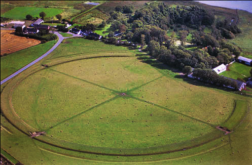
These five archaeological sites comprise a system of monumental ring-shaped Viking-Age fortresses sharing a uniform geometric design. Constructed between about 970 and 980 CE, the fortresses at Aggersborg, Fyrkat, Nonnebakken, Trelleborg and Borgring were positioned strategically near important land and sea routes, and each made use of the natural topography of their surrounding landscape for defensive purposes. They are an emblematic demonstration of the centralized power of the Jelling Dynasty, and a testimony to the socio-political transformations that the Danish realm underwent in the late 10th century.
Description from the UNESCO World Heritage Centre (CC BY-SA IGO 3.0).
Why Viking Age Ring Fortresses Is Listed
- (iii)
- A unique testimony to a cultural tradition or civilisation.
- (iv)
- An outstanding example of a type of building or landscape.

Møns Klint
Denmark · 54.9642° N, 12.5522° E · 41 km² · 75 km from Malmö
Møns Klint is a 6 km stretch of limestone and chalk cliffs along the eastern coast of the Danish island of Møn in the Baltic Sea, and as of July 2025 a World Heritage Site. Some of the cliffs fall a sheer 120 m to the sea below. The highest cliff is Dronningestolen, which is 128 m above sea level. The area around Møns Klint consists of woodlands, pastures, ponds and steep hills, including Aborrebjerg which, with a height of 142 m, is one of the highest points in Denmark. The cliffs and adjacent park are now protected as a nature reserve. Møns Klint receives around 250,000 visitors a year. There are clearly marked paths for walkers, riders and cyclists. The path along the cliff tops leads to steps down to the shore in several locations.
On 29 May 2007, close to the cliff tops, the GeoCenter Møns Klint was opened by Queen Margrethe. The museum was designed by PLH Architects, the winners of an international design competition.
On 13 July 2025, Møns Klint was one of the items accepted for inclusion on UNESCO's World Heritage List.
Adapted from Wikipedia: Møns Klint (CC BY-SA 4.0).
Why Møns Klint Is Listed
- (viii)
- An outstanding example of major stages of the Earth's history.
More about Møns Klint
UNESCO's Description
Featuring a dramatic glaciotectonic landscape shaped by Pleistocene glaciers, the property includes chalk cliffs, rolling hills, kame and kettle topography, and outwash plains. Visible cliff cross-sections reveal intense folding and faulting of Cretaceous chalk and Quaternary sediments. The area supports rare habitats like calcareous grasslands and beech forests, hosting diverse flora and fauna, including 18 species of orchid, and the almost-threatened Large Blue butterfly. Erosion continuously exposes fossils and reshapes the cliffs.
From the UNESCO World Heritage Centre (CC BY-SA IGO 3.0).
Geology
The chalk forming the cliffs consists of the remains of shells from millions of microscopic creatures (coccolithophores) which lived on the seabed over 70 million years ago. As a result of huge pressure from glaciers moving west, the terrain was compacted and pushed upwards, forming a number of hills and folds. When the ice melted at the end of the last ice age about 11,000 years ago, the cliffs emerged. They form part of the same deposits as the cliffs of Rügen, Germany, on the other side of the Baltic. Today, it is possible to find fossils of various types of shellfish as the sea continues to erode the chalk.
Sections adapted from Wikipedia: Møns Klint (CC BY-SA 4.0).
The Bony Fish Fossils of the Western Limfjord – Evolution and Climate Adaptation in the Earliest Eocene
Denmark · 56.8957° N, 8.7520° E · 65 km from Viborg
The serial property, located in the Western Limfjord sea of northern Jutland, Denmark, comprise the coastal cliffs of Hanklit and Knudeklint, which contain some of the world’s best-preserved fossil fishes. The property represents the oldest and most important site for understanding the early evolution and diversification of modern bony fishes (teleosts) following the end-Cretaceous mass extinction. Preserved within diatomite-rich deposits and volcanic ash layers, the exceptional fossil record spans the Paleocene–Eocene Thermal Maximum (PETM) and the subsequent cooling period, providing unique evidence of biotic responses to major climatic change. The property contains abundant and exceptionally well-preserved marine and terrestrial fossils, including fishes, sea turtles, birds, insects, plants, and microfossils, offering an unparalleled insight into the earliest Eocene biosphere. It preserves between 25 and 29 fish orders and more than 80 fish species, documenting the evolution and adaptation of early modern fish lineages during a period of rapid environmental change.
Description from the UNESCO World Heritage Centre (CC BY-SA IGO 3.0).
Why The Bony Fish Fossils of the Western Limfjord – Evolution and Climate Adaptation in the Earliest Eocene Is Listed
- (viii)
- An outstanding example of major stages of the Earth's history.
Shared With Neighbouring Countries
These sites cross the border. Each is written up on the page of the country UNESCO lists first.

World Heritage in Denmark: Quick Answers
- How many UNESCO World Heritage Sites are in Denmark?
- Denmark has 13 World Heritage Sites: 8 cultural and 5 natural. 1 of them is shared with a neighbouring country.
- What was the first World Heritage Site in Denmark?
- Jelling Heritage Site, inscribed in 1994. The most recent is The Bony Fish Fossils of the Western Limfjord – Evolution and Climate Adaptation in the Earliest Eocene, inscribed in 2026.
- What are the natural World Heritage Sites in Denmark?
- Ilulissat Icefjord, Wadden Sea, Stevns Klint, Møns Klint, The Bony Fish Fossils of the Western Limfjord – Evolution and Climate Adaptation in the Earliest Eocene.
- Are any World Heritage Sites in Denmark in danger?
- None of the World Heritage Sites in Denmark is on UNESCO's List of World Heritage in Danger.