
UNESCO World Heritage Sites in Cambodia
Cambodia has 5 sites on the UNESCO World Heritage List (5 cultural), the first inscribed in 1992 (Angkor). The map below plots every one of them alongside the rest of the List, and each site is written up in full further down the page.
- World Heritage Sites
- 5
- Cultural
- 5
- Natural and Mixed
- 0
- First Inscribed
- 1992
Map of World Heritage Sites in Cambodia
CulturalNaturalMixedIn DangerLarge dots are in Cambodia. Click a dot to read about the site.

Angkor
Cambodia · 13.4409° N, 103.8591° E · 401 km² · 8 km from Siem Reap
Angkor is one of the most important archaeological sites in South-East Asia. Stretching over some 400 km2, including forested area, Angkor Archaeological Park contains the magnificent remains of the different capitals of the Khmer Empire, from the 9th to the 15th century. They include the famous Temple of Angkor Wat and, at Angkor Thom, the Bayon Temple with its countless sculptural decorations. UNESCO has set up a wide-ranging programme to safeguard this symbolic site and its surroundings.
Description from the UNESCO World Heritage Centre (CC BY-SA IGO 3.0).
Why Angkor Is Listed
- (i)
- A masterpiece of human creative genius.
- (ii)
- An important interchange of human values.
- (iii)
- A unique testimony to a cultural tradition or civilisation.
- (iv)
- An outstanding example of a type of building or landscape.

Preah Vihear Temple
Cambodia · 14.3906° N, 104.6803° E · 2 km² · 71 km from Phnum Tbeng Meanchey
Preah Vihear (lit. "vihāra of the gods") (Khmer: ប្រាសាទព្រះវិហារ Prasat Preah Vihear) is an ancient edifice built by the Khmer Empire as a Hindu temple on top of a 525-metre (1,722 ft) cliff in the Dângrêk Mountains, in Cambodia. Over time, it became a Buddhist temple.
As a key edifice of the empire's spiritual life, Preah Vihear was supported and modified by successive kings and thus bears elements of several architectural styles. It is unusual among Khmer temples in being constructed along a long north–south axis, rather than having the conventional rectangular plan with orientation toward the east. The temple gives its name to the surrounding Preah Vihear province.
In 1962, after a lengthy dispute between Cambodia and Thailand over ownership, the International Court of Justice in the Hague ruled that the temple is in Cambodia. On 7 July 2008, Preah Vihear was listed as a UNESCO World Heritage Site. This prompted an escalation in the dispute between Cambodia and Thailand over the temple, which was settled in favour of Cambodia by another ICJ ruling in 2013.
Adapted from Wikipedia: Preah Vihear (CC BY-SA 4.0).
Why Preah Vihear Temple Is Listed
- (i)
- A masterpiece of human creative genius.
More about Preah Vihear Temple
UNESCO's Description
Situated on the edge of a plateau that dominates the plain of Cambodia, the Temple of Preah Vihear is dedicated to Shiva. The Temple is composed of a series of sanctuaries linked by a system of pavements and staircases over an 800 metre long axis and dates back to the first half of the 11th century AD. Nevertheless, its complex history can be traced to the 9th century, when the hermitage was founded. This site is particularly well preserved, mainly due to its remote location. The site is exceptional for the quality of its architecture, which is adapted to the natural environment and the religious function of the temple, as well as for the exceptional quality of its carved stone ornamentation.
From the UNESCO World Heritage Centre (CC BY-SA IGO 3.0).
History
Construction of the first temple on the site began in the early 9th century. Both then and in the following centuries, it was dedicated to the Hindu god Shiva in his manifestations as the mountain gods Sikharesvara and Bhadresvara. The earliest surviving parts of the temple, however, date from the Koh Ker period in the early 10th century, when the empire's capital was at the city of that name. Today, elements of the Banteay Srei style of the late 10th century can be seen, but most of the temple was constructed during the reigns of the Khmer kings Suryavarman I (1006–1050) and Suryavarman II (1113–1150).
Location
The temple was built at the top of Poy Tadi, a steep cliff in the Dângrêk Mountain range that is the natural border between Cambodia and Thailand. The site is listed by Cambodia as being in Svay Chrum village, Kan Tout commune, in Choam Khsant District of Preah Vihear Province. It is 140 km from Angkor Wat and 418 km from Phnom Penh. In 1962, the ICJ ruled that the temple building belonged to Cambodia.
The temple complex runs 800 m (2,600 ft) along a north–south axis, facing the plains to the north, from which it is cut off by the international border.
Sections adapted from Wikipedia: Preah Vihear (CC BY-SA 4.0).
Key Facts
| Established | 893 CE |
|---|---|
| Area | 1.5 km² |
Facts from Wikidata Q45949 (CC0).
Visiting Preah Vihear Temple
Prasat Preah Vihear (ព្រះវិហារ) is a Khmer (Cambodian) temple crowning a 525-m cliff in the Dângrêk Mountains in Cambodia, across the border from Si Saket and Kantharalak in northeastern Thailand. It is also the name of the surrounding province.
Travel notes adapted from Wikivoyage: Preah Vihear (CC BY-SA 4.0).

Sambor Prei Kuk
Cambodia · 12.8673° N, 105.0400° E · 8 km² · 80 km from Kompong Chhnang
Sambor Prei Kuk (Isanapura) (Khmer: សំបូរព្រៃគុហ៍, Sâmbor Prey Kŭh [sɑmboː prəj kuʔ]) is an archaeological site in Cambodia located in Kampong Thom Province, 30 km (19 mi) north of Kampong Thom, the provincial capital, 176 km (109 mi) east of Angkor and 206 km (128 mi) north of Phnom Penh. The now ruined complex dates back to the Pre-Angkorian Chenla Kingdom (late 6th to 9th century), established by king Isanavarman I as central royal sanctuary and capital, known then as "Isanapura" (Khmer: ឦសានបុរៈ, Eisanbŏreă [ʔəjsaːnɓoreaʔ]). In 2017, Sambor Prei Kuk was declared a UNESCO World Heritage Site.
Located on the Eastern bank of the Tonle Sap lake, close to the Steung Saen River, the central part of Sambor Prei Kuk is divided into three main groups. Each group has a square layout surrounded by a brick wall. The structures of the overall archaeological area were constructed at variable times: the southern and north groups (7th century) by Isanavarman I, who is considered a possible founder of the city and the central group (later date).
The buildings of Sambor Prei Kuk are characteristic of the Pre-Angkorean period with a simple external plan.
Adapted from Wikipedia: Sambor Prei Kuk (CC BY-SA 4.0).
Why Sambor Prei Kuk Is Listed
- (ii)
- An important interchange of human values.
- (iii)
- A unique testimony to a cultural tradition or civilisation.
- (vi)
- A direct association with events, ideas or beliefs of universal significance.
More about Sambor Prei Kuk
UNESCO's Description
The archaeological site of Sambor Prei Kuk, “the temple in the richness of the forest” in the Khmer language, has been identified as Ishanapura, the capital of the Chenla Empire that flourished in the late 6th and early 7th centuries AD. The property comprises more than a hundred temples, ten of which are octagonal, unique specimens of their genre in South-East Asia. Decorated sandstone elements in the site are characteristic of the pre-Angkor decorative idiom, known as the Sambor Prei Kuk Style. Some of these elements, including lintels, pediments and colonnades, are true masterpieces. The art and architecture developed here became models for other parts of the region and lay the ground for the unique Khmer style of the Angkor period.
From the UNESCO World Heritage Centre (CC BY-SA IGO 3.0).
History
Isanavarman I reigned over the Chenla Kingdom between 616 and 637 AD, taking Isanapura as his capital and it is argued that he built the main temple Prasat Sambor (Group N), as there is an inscription on the site attributed to his reign and dated 13 September 627 AD. The king is also known for sending his first embassy to the court of the Sui dynasty in China (616-617). Chenla conquered different principalities in the Northwest of Cambodia after the end of the Chinese reign period yǒnghuī (永徽) (i. e. after 31 January 656), which previously (in 638/39) paid tribute to China. An inscription dating from the reign of Isanarvarman I claimed that he was, "the King of Kings, who rules over Suvarnabhumi".
Sections adapted from Wikipedia: Sambor Prei Kuk (CC BY-SA 4.0).
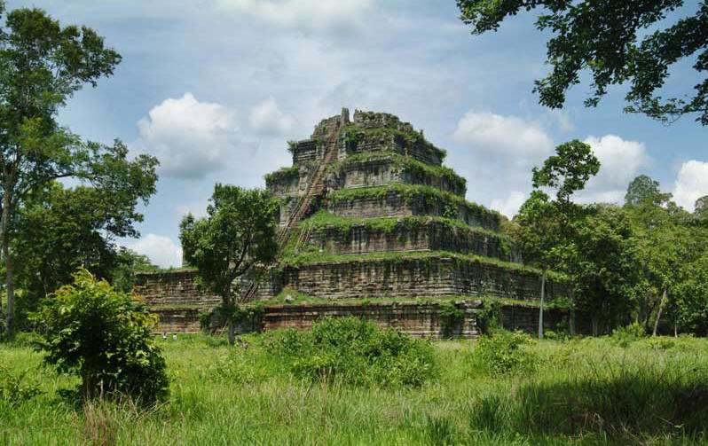
Koh Ker
Cambodia · 13.7499° N, 104.5473° E · 12 km² · 46 km from Phnum Tbeng Meanchey
Koh Ker (Khmer: ប្រាសាទកោះកេរ្ដិ៍, Prasat Kaôh Kértĕ [praːsaːt kɑh keː]) is a remote archaeological site in northern Cambodia about 120 kilometres (75 mi) away from Siem Reap and the ancient site of Angkor. It is a jungle filled region that is sparsely populated. More than 180 sanctuaries were found in a protected area of 81 square kilometres (31 sq mi). Only about two dozen monuments can be visited by tourists because most of the sanctuaries are hidden in the forest and the whole area is not fully demined.
Koh Ker is the modern name for an important city of the Khmer empire. In inscriptions the town is mentioned as Lingapura (city of lingams) or Chok Gargyar (translated as city of glance, or as iron tree forest).
Under the reign of the kings Jayavarman IV and Harshavarman II Koh Ker was briefly the capital of the whole empire (928–944 AD). Jayavarman IV enforced an ambitious building program. An enormous water-tank and about forty temples were constructed under his rule. The most significant temple‑complex, a double sanctuary (Prasat Thom/Prang), follows a linear plan and not a concentric one like most of the temples of the Khmer kings.
Adapted from Wikipedia: Koh Ker (CC BY-SA 4.0).
Why Koh Ker Is Listed
- (ii)
- An important interchange of human values.
- (iv)
- An outstanding example of a type of building or landscape.
More about Koh Ker
UNESCO's Description
The archaeological site of Koh Ker is a sacred urban ensemble of numerous temples and sanctuaries including sculptures, inscriptions, wall paintings, and archaeological remains. Constructed over a twenty-three-year period, it was one of two rival Khmer Empire capitals – the other being Angkor – and was the sole capital from 928 to 944 CE. Established by King Jayavarman IV, his sacred city was believed to be laid out on the basis of ancient Indian religious concepts of the universe. The new city demonstrated unconventional city planning, artistic expression and construction technology, especially the use of very large monolithic stone blocks.
From the UNESCO World Heritage Centre (CC BY-SA IGO 3.0).
Geography
Koh Ker is situated between the southern slopes of the Dangrek mountains, the Kulen mountains (Phnom Kulen) in the south-west, and the Tbeng mountain (Phnom Tbeng, near Tbeng Meanchey) in the east. Most parts of the hilly ground are covered by jungle, but most of the trees shed their leaves seasonally. The city of Koh Ker was on the most important strategic route of the Khmer empire. Coming from Angkor and Beng Mealea to Koh Ker this road led to the Preah Vihear temple and from there to Phimai in Thailand and Wat Phu in Laos. The region of Koh Ker is relatively dry. Numerous water-tanks and canals were built during the 9th and the 10th century to ensure the water supply. These days water is pumped up from a depth of 30 to 40 metres (98 to 131 ft).
History
Jayavarman IV ruled from 928 to 941 at Koh Ker. He was believed to have been the local king at this remote site, possibly his homeland, before he became king of the whole empire. That could explain why he had his residence at Koh Ker and not at Roluos (Hariharalaya) or at Yashodharapura (Angkor) like the kings before him. Some historians think that Jayavarman IV was a usurper; but, the majority of them believe that he was a legitimate ruler who could ascend to the throne because he married a half-sister of king Yasovarman I (889 – 900). What is certain is that the two sons of Yasovarman I (Harshavarman I, who ruled from 900 to 922 and Isanavarman II, who ruled from 922 to 925?) had no children.
Description
The center of the ancient city was in the north-east corner of the baray (water-tank). Inscriptions say at least ten thousand inhabitants lived there during the rule of Jayavarman IV. Past researchers believed a square wall with a side length of 1.2 km (1,312 yd) protected the town. But new research indicates that the linear structures found in this part of Koh Ker were dykes of ancient canals. Concerning the wooden buildings of the Khmer time no artefacts are found.
Laterite, sandstone and brick were used as construction materials in Koh Ker. Laterite and sandstone of excellent quality were quarried in great quantities in the region of Koh Ker, so the transport of the stones to the site was no problem. The bricks produced were small, regular and very solid.
Modern History
In the second part of the 19th century, French adventurers ranged the forests around the site of Koh Ker while hunting game. They brought word of the structures in the area back to France. The French researchers Lunet de Lajonquière and Étienne Aymonier came to Koh Ker. They saw the main temple-complex Prasat Thom/Prang, the Baray and a group of linga-shrines. They also discovered a few subsections of a chaussée (i.e. highway) with a breadth of more than 8 m (26 ft). They supposed that a road once connected Koh Ker with Wat Phu (today in southern Laos).
Sections adapted from Wikipedia: Koh Ker (CC BY-SA 4.0).
Visiting Koh Ker
Koh Ker is a remote temple site about 120 km northeast of Siem Reap, Cambodia, that has been left to the jungle for a millennium and mostly unrestored. Since 2023 this great archaeological site has been on the UNESCO World Heritage List.
Travel notes adapted from Wikivoyage: Koh Ker (CC BY-SA 4.0).

Cambodian Memorial Sites: From centres of repression to places of peace and reflection
Cambodia · 11.4844° N, 104.9020° E · 8 km from Phnom Penh
The Cambodian Memorial Sites: From centres of repression to places of peace and reflection is a UNESCO World Heritage Site which consists of the former M-13 prison (early repression), the Tuol Sleng Genocide Museum (former S-21 prison) and the Choeung Ek Genocidal Center (former execution site of S-21). These sites have been preserved and memorialized since the fall of the Khmer Rouge regime. They stand as testimony to the horrors carried out by the communist Khmer Rouge from 1975 to 1979. Formerly sites of mass detention, torture, and execution, these locations have been transformed into profound spaces of remembrance and learning. Today, they serve as solemn memorials to one of the 20th century’s most tragic genocides and offer opportunities for reflection, healing, and the pursuit of peace. UNESCO’s recognition of these memorials represents a significant step in safeguarding Cambodia’s painful history, paying tribute to the resilience of its people, and raising global awareness about the devastating impact of totalitarianism and mass violence.
Adapted from Wikipedia: Cambodian Memorial Sites (CC BY-SA 4.0).
Why Cambodian Memorial Sites: From centres of repression to places of peace and reflection Is Listed
- (vi)
- A direct association with events, ideas or beliefs of universal significance.
More about Cambodian Memorial Sites: From centres of repression to places of peace and reflection
UNESCO's Description
The property consists of three locations that reflect the human rights abuses of the Khmer Rouge regime in Cambodia from 1971 to 1979. The three component parts represent the widespread violence during this period: the former M-13 prison (early repression), the Tuol Sleng Genocide Museum (former S-21 prison), and the Choeung Ek Genocidal Center (former execution site of S-21). These places have been preserved and memorialized since the regime’s fall. The Tuol Sleng Museum maintains extensive archives and collections related to this period, mainly documented by the Extraordinary Chambers in the Courts of Cambodia (ECCC).
From the UNESCO World Heritage Centre (CC BY-SA IGO 3.0).
History
Between 1975 and 1979, Cambodia came under the rule of the Khmer Rouge, a radical Maoist regime led by Pol Pot. Driven by a vision of creating a classless, agrarian society, the regime launched a ruthless campaign of social reengineering that resulted in the deaths of an estimated 1.7 to 2 million people—nearly a quarter of the nation’s population.
The Khmer Rouge sought to dismantle all aspects of traditional society, including money, private property, religion, and education. Cities were emptied, and entire populations were forcibly relocated to rural labor camps. Intellectuals, professionals, religious figures, and even children suspected of disloyalty were detained, tortured, and executed.
Sections adapted from Wikipedia: Cambodian Memorial Sites (CC BY-SA 4.0).
World Heritage in Cambodia: Quick Answers
- How many UNESCO World Heritage Sites are in Cambodia?
- Cambodia has 5 World Heritage Sites: 5 cultural.
- What was the first World Heritage Site in Cambodia?
- Angkor, inscribed in 1992. The most recent is Cambodian Memorial Sites: From centres of repression to places of peace and reflection, inscribed in 2025.
- Are any World Heritage Sites in Cambodia in danger?
- None of the World Heritage Sites in Cambodia is on UNESCO's List of World Heritage in Danger.