
Map of Mozambique
Mozambique is a country in Africa with its capital at Maputo, home to about 35.63 million people across 801,590 km². The interactive map below plots 34 cities and towns, 12 rivers, 2 lakes, 2 mountain summits, 1 major dams and 6 ports recorded for Mozambique in YearMaps.
- Population
- 35.63 million
- Area
- 801,590 km²
- Capital
- Maputo
- Continent
- Africa
Interactive Map of Mozambique
Centred on Maputo at 25.9533° S, 32.5872° E. Use the layer panel to switch on rivers, dams, ports, peaks and historical borders.
About Mozambique
Mozambique, officially the Republic of Mozambique, is a country in Southern Africa bordered by the Indian Ocean to the east, Tanzania to the north, Malawi and Zambia to the northwest, Zimbabwe to the west, and Eswatini and South Africa to the south and southwest. The sovereign state is separated from the Comoros, Mayotte, and Madagascar through the Mozambique Channel to the east. The capital and largest city is Maputo.
Between the 7th and 11th centuries, a series of Swahili port towns developed in the area, which contributed to the development of a distinct Swahili culture and dialect. In the late medieval period, these towns were frequented by traders from Somalia, Ethiopia, Egypt, Arabia, Persia, and India. The voyage of Vasco da Gama in 1498 marked the arrival of the Portuguese, who began a gradual process of colonisation and settlement in 1505. After over four centuries of Portuguese rule, Mozambique gained independence in 1975, becoming the People's Republic of Mozambique shortly thereafter. After only two years of independence, the country descended into an intense and protracted civil war lasting from 1977 to 1992. In 1994, Mozambique held its first multiparty elections and has since remained a relatively stable presidential republic, although it still faces a low-intensity insurgency mainly in the furthest regions from the southern capital and where Islam is the dominant faith.
Mozambique is endowed with rich and extensive natural resources. The country's economy is based chiefly on fishery—mostly molluscs, crustaceans and echinoderms—and agriculture, with a growing industry of food and beverages, chemical manufacturing, aluminium and oil. The tourism sector is expanding. Mozambique's GDP grew significantly after 2001, but since 2014/15, both a significant decrease in household real consumption and a sharp rise in economic inequality have been observed. The nation remains one of the poorest and most underdeveloped countries in the world, ranking low in GDP per capita, human development, measures of inequality and average life expectancy.
Mozambique's population of around 34,777,605 (as of 2024 estimates; a 2.96% increase from 2023) consists of more than 2,000 ethnic groups and is composed overwhelmingly of Bantu peoples. However, the only official language in the country is Portuguese, which is spoken in urban areas as a first or second language by most, and generally as a lingua franca between younger Mozambicans with access to formal education. The most important local languages include Tsonga, Makhuwa, Sena, Chichewa, and Swahili.
Summary adapted from Wikipedia: Mozambique (CC BY-SA 4.0).

Geography and Climate of Mozambique
In the first half of the second millennium A.D., northern Mozambican port towns were frequented by traders from Somalia, Ethiopia, Egypt, Arabia, Persia, and India. The Portuguese were able to wrest much of the coastal trade from Arab Muslims in the centuries after 1500, and they set up their own colonies. Portugal did not relinquish Mozambique until 1975. Large-scale emigration, economic dependence on South Africa, a severe drought, and a prolonged civil war hindered the country's development until the mid-1990s. The ruling Front for the Liberation of Mozambique (FRELIMO) party formally abandoned Marxism in 1989, and a new constitution the following year provided for multiparty elections and a free-market economy. A UN-negotiated peace agreement between FRELIMO and rebel Mozambique National Resistance (RENAMO) forces ended the fighting in 1992. In 2004, Mozambique underwent a delicate transition as Joaquim CHISSANO stepped down after 18 years in office. His elected successor, Armando GUEBUZA, served two terms and then passed executive power to Filipe NYUSI in 2015. RENAMO’s residual armed forces intermittently engaged in a low-level insurgency after 2012, but a 2016 cease-fire eventually led to the two sides signing a comprehensive peace deal in 2019. Since 2017, violent extremists -- who an official ISIS media outlet recognized as ISIS's network in Mozambique for the first time in 2019 -- have been conducting attacks against civilians and security services in the northern province of Cabo Delgado. In 2021, Rwanda and the Southern African Development Community deployed forces to support Mozambique’s efforts to counter the extremist group.
- Location
- Southeastern Africa, bordering the Mozambique Channel, between South Africa and Tanzania.
- Climate
- Tropical to subtropical.
- Terrain
- Mostly coastal lowlands, uplands in center, high plateaus in northwest, mountains in west.
- Highest point
- Monte Binga 2,436 m.
- Lowest point
- Indian Ocean 0 m.
- Coastline
- 2,470 km.
- Land borders
- Total: 4,783 km; border countries: Malawi 1498 km; South Africa 496 km; Eswatini 108 km; Tanzania 840 km; Zambia 439 km; Zimbabwe 1,402 km.
- Major rivers
- Rio Zambeze (Zambezi) river mouth (shared with Zambia [s]), Angola, Namibia, Botswana, and Zimbabwe) - 2,740 km; Rio Limpopo river mouth (shared with South Africa [s], Botswana, and Zimbabwe) - 1,800 km note: [s] after country name indicates river source; [m] after country name indicates river mouth.
- Major lakes
- Fresh water lake(s): Lake Malawi (shared with Malawi and Tanzania) - 22,490.
- Natural resources
- Coal, titanium, natural gas, hydropower, tantalum, graphite.
- Land use
- Agricultural land: 52.8% (2023 est.); arable land: 7.2% (2023 est.); permanent crops: 0.5% (2023 est.); permanent pasture: 45.1% (2023 est.); forest: 41.7% (2023 est.); other: 5.5% (2023 est.)
- Natural hazards
- Severe droughts; devastating cyclones and floods in central and southern provinces.
- Geographic note
- The Zambezi River flows through the north-central and most fertile part of the country.
- Languages
- Makhuwa 26.1%, Portuguese (official) 16.6%, Tsonga 8.6%, Nyanja 8.1, Sena 7.1%, Lomwe 7.1%, Chuwabo 4.7%, Ndau 3.8%, Tswa 3.8%, other Mozambican languages 11.8%, other 0.5%, unspecified 1.8% (2017 est.)
- Religions
- Catholic 27.3%, Islam 19.1%, Pentecostal 16.7%, Saio/Zione 16.3%, no religion 13.5%, other 4.3%, Anglican 1.7%, unknown 1.2% (2017 est.)
- Ethnic groups
- African 99% (Makhuwa, Tsonga, Lomwe, Sena, and others), Mestizo 0.8%, other (includes European, Indian, Pakistani, Chinese) 0.2% (2017 est.)
- Economy
- Low-income East African economy; subsistence farming dominates labor force; return to growth led by agriculture and extractive industries; Islamist insurgency threatens natural gas projects in north; ongoing foreign debt restructuring and resolution under IMF Highly Indebted Poor Countries (HIPC) initiative.
From the CIA World Factbook (public domain), archived edition of 2026-01-22. The Factbook is no longer updated, so figures reflect that edition.
Mozambique in Numbers
- Population
- 35.63 million
- GDP
- US$22.3 billion
- GDP per person
- US$627
- Life expectancy
- 63.8 years
- Population growth
- 2.85% a year
- Population density
- 44 per km²
- Urban population
- 37.2%
- Surface area
- 799,380 km²
- Forest cover
- 41.3%
- Arable land
- 10.5%
- Access to electricity
- 36.9%
- Internet users
- 20.5%
Indicators from World Bank Open Data (CC BY 4.0). The year under each figure is its reference year.
Mozambique in Depth
History
Bantu-speaking peoples migrated into Mozambique as early as the 4th century BC. It is believed between the 1st and 5th centuries AD, waves of migration from the west and north went through the Zambezi River valley and then gradually into the plateau and coastal areas of Southern Africa. They established agricultural communities or societies based on herding cattle. They brought with them the technology for smelting and smithing iron.
From the late first millennium AD, vast Indian Ocean trade networks extended as far south as present day Vilankulo, as evidenced by the ancient port town of Chibuene. Beginning in the 9th century, a growing involvement in Indian Ocean trade led to the development of numerous port towns along the entire East African coast, including modern day Mozambique.
Geography
At 309,475 sq mi (801,537 km2), Mozambique is the world's 35th-largest country. Mozambique is located on the southeast coast of Africa and is bound by Eswatini to the south, South Africa to the southwest, Zimbabwe to the west, Zambia and Malawi to the northwest, Tanzania to the north and the Indian Ocean to the east. Mozambique lies between latitudes 10° and 27°S, and longitudes 30° and 41°E.
The country is divided into two topographical regions by the Zambezi River. To the north of the Zambezi, the narrow coastal strip gives way to inland hills and low plateaus. Rugged highlands are further west; they include the Niassa highlands, Namuli or Shire highlands, Angonia highlands, Tete highlands and the Makonde plateau, covered with miombo woodlands.
Economy
Mozambique is one of the poorest and most underdeveloped countries in the world, even though between 1994 and 2006 its average annual GDP growth was approximately 8%. Since 2014/15, household real consumption has decreased significantly and a sharp rise in economic inequality has been observed. The IMF classifies Mozambique as a heavily indebted poor country. In a 2006 survey, three-quarters of Mozambicans said that in the past five years their economic position had remained the same or become worse.
Mozambique's official currency is the metical (in October 2023, US$1 was roughly equivalent to 64 meticals). The U.S. dollar, South African rand, and the euro are widely accepted and used in business transactions. The minimum legal salary is around US$60 per month.
Demographics
The north-central provinces of Zambezia and Nampula are the most populous, with about 45% of the population. The estimated four million Makua are the dominant group in the northern part of the country; the Sena and Shona (mostly Ndau and Manyika) are prominent in the Zambezi valley, and the Tsonga people dominate southern Mozambique. Other groups include Makonde, Yao, Swahili, Tonga, Chopi, and Nguni (including Zulu).
Sections adapted from Wikipedia: Mozambique (CC BY-SA 4.0).
Mozambique: Key Facts
| Currency | Mozambican metical |
|---|---|
| Official language | Portuguese |
| Head of state | Daniel Chapo |
| Head of government | Maria Benvinda Levy |
| Calling code | +258 |
| Internet domain | .mz |
| Highest point | Monte Binga |
| Lowest point | Mozambique Channel |
| Established | 25 June 1975 |
Facts from Wikidata Q1029 (CC0).
History of Mozambique: Empires and States
The atlas records 5 polities whose mapped territory included part of Mozambique, from The Portuguese Empire in 1534 CE to 2024 CE. They are listed in the order they first appear.
| Polity | Period here | Extent |
|---|---|---|
| The Portuguese Empire | 1534–1910 CE | Most |
| Kingdom of Portugal | 1824–1910 CE | Most |
| Portuguese Republic | 1911–1925 CE | Most |
| Estado Novo | 1926–1975 CE | Most |
| Mozambique | 1976–2024 CE | Most |
Historical Maps of Mozambique
Mozambique on the world map in each year one of these states held it:
Derived by testing mapped cities against dated territorial polygons. Dates are when the polygons cover this place, not the polity's whole lifespan, and polities absent from the source dataset are not listed.
Visiting Mozambique
Mozambique (Portuguese: Moçambique) is a country on the Indian Ocean coast of Southern Africa. From the Monte Binga peak, 2,436 m (7,992 ft) high, to the stunning beaches along the coast, Mozambique is a country of contrasts. As well as some of the best colonial era architecture and relics to be found on the continent, Mozambique has also preserved its African cultural heritage, which can be experienced through art, music and food. Its eastern coastline along the Indian Ocean is more than 1,000 km long, a fantastic draw for scuba divers, fishermen, sailors and beach lovers.
Travel notes adapted from Wikivoyage: Mozambique (CC BY-SA 4.0).
Largest Cities in Mozambique
34 cities recorded. Ranked by metropolitan population. A port city's harbour is written up on the page of its sea.
| # | Name | Population | Region | Role |
|---|---|---|---|---|
| 1 | Maputo | 1.45 million | Maputo | National capital |
| 2 | Matola | 543,907 | Maputo | Populated place |
| 3 | Beira | 530,604 | Sofala | Admin-1 capital |
| 4 | Nampula | 388,526 | Nampula | Admin-1 capital |
| 5 | Chimoio | 256,936 | Manica | Admin-1 capital |
| 6 | Nacala | 224,795 | Nampula | Populated place |
| 7 | Quelimane | 188,964 | Zambezia | Admin-1 capital |
| 8 | Tete | 129,316 | Tete | Admin-1 capital |
| 9 | Xai-Xai | 128,805 | Gaza | Admin-1 capital |
| 10 | Maxixe | 119,868 | Inhambane | Admin-1 capital |
| 11 | Inhambane | 115,776 | Inhambane | Admin-1 capital |
| 12 | Pemba | 110,643 | Cabo Delgado | Admin-1 capital |
| 13 | Lichinga | 109,839 | Nassa | Admin-1 capital |
| 14 | Dondo | 78,648 | Sofala | Populated place |
| 15 | Cuamba | 73,268 | Nassa | Populated place |
| 16 | Montepuez | 72,279 | Cabo Delgado | Populated place |
| 17 | Mocuba | 68,984 | Zambezia | Populated place |
| 18 | Angoche | 57,835 | Nampula | Populated place |
| 19 | Mocambique | 54,315 | Nampula | Populated place |
| 20 | Moatize | 42,000 | Tete | Populated place |
| 21 | Mocimboa | 27,909 | Cabo Delgado | Populated place |
| 22 | Macia | 23,156 | Gaza | Populated place |
| 23 | Marrupa | 8,762 | Nassa | Populated place |
| 24 | Nicuadala | 6,945 | Zambezia | Populated place |
| 25 | Manica | 4,000 | Manica | Populated place |
The other 9 (population, region, role)
- Ligonha · 3,500 · Nampula · Populated place
- Luangwa · 3,065 · Tete · Populated place
- Quissico · 1,210 · Inhambane · Populated place
- Massangena · 650 · Gaza · Populated place
- Panda · 602 · Inhambane · Populated place
- Chiramba · 556 · Sofala · Populated place
- Espungabera · 393 · Manica · Populated place
- Mapai · 201 · Gaza · Populated place
- Vilanculos · 177 · Inhambane · Populated place
Highest Mountains in Mozambique
2 mountains recorded. Ranked by summit elevation above sea level. A summit on a border is listed under both countries.
| # | Name | Elevation | Feet | Region |
|---|---|---|---|---|
| 1 | Mount Binga | 2,436 m | 7,992 ft | Africa |
| 2 | Serra Namúli | 2,419 m | 7,936 ft | Africa |
Major Dams in Mozambique
1 dam recorded. Ranked by structural height.
| # | Name | Height | River | Capacity | Completed |
|---|---|---|---|---|---|
| 1 | Cahora Bassa Dam | 171 m | Zambezi | 2,075 MW | 1974 |
Largest Lakes in Mozambique
2 lakes recorded. Ranked by mapped surface area. A lake on a border is listed under each country it lies in, with the area of the whole lake.
| # | Name | Surface Area | Type |
|---|---|---|---|
| 1 | Lake Malawi | 28,974 km² | Lake |
| 2 | Lago de Cahora Bassa | 1,556 km² | Reservoir |

Lake Malawi
Lake · 28,974 km²
Lake Malawi is a lake in Malawi, Mozambique and Tanzania, with a mapped surface area of about 28,974 km². About 24% of its surface lies in Mozambique, and the rest in Malawi and Tanzania.
Lake Malawi, also known as Lake Nyasa in Tanzania and Lago Niassa in Mozambique, (Swahili: Ziwa Nyasa) is an African Great Lake and the southernmost lake in the East African Rift system, located between Malawi, Mozambique and Tanzania.
It is the fourth largest freshwater lake in the world by volume, the ninth largest lake in the world by area and the third largest and second deepest lake in Africa. Lake Malawi is home to more species of fish than any other lake in the world, including at least 700 species of cichlid. The Mozambique portion of the lake was officially declared a reserve by the Government of Mozambique on June 10, 2011, while in Malawi a portion of the lake is included in Lake Malawi National Park.
Lake Malawi is a meromictic lake, meaning that its water layers do not mix. The permanent stratification of Lake Malawi's water and the oxic-anoxic boundary are maintained by moderately small chemical and thermal gradients.
Adapted from Wikipedia: Lake Malawi (CC BY-SA 4.0).
- Surface area
- 28,974 km²
- Area rank
- #9 of 756 indexed
- Type
- Lake
- Countries
- Malawi, Mozambique, Tanzania
- Coordinates
- -11.6430°, 34.6456°
Among the 756 water bodies with a mapped extent in YearMaps, Lake Malawi ranks #9 by surface area, after Great Bear Lake (30,907 km²) and ahead of Great Slave Lake (27,481 km²). Areas are computed from the mapped outline and are approximate.
- Other water nearby:
- Lago de Cahora Bassa (1,556 km²)
More about Lake Malawi
Geography
Lake Malawi is between 560 kilometres (350 mi) and 580 kilometres (360 mi) long, and about 75 kilometres (47 mi) wide at its widest point. The lake has a total surface area of about 29,600 square kilometres (11,400 sq mi). The lake is 706 m (2,316 ft) at its deepest point, located in a major depression in the north-central part. Another smaller depression in the far north reaches a depth of 528 m (1,732 ft). The southern half of the lake is shallower; less than 400 m (1,300 ft) in the south-central part and less than 200 m (660 ft) in the far south.
The lake has shorelines on western Mozambique, eastern Malawi, and southern Tanzania.
Geological history
Malawi is one of the major Rift Valley lakes and an ancient lake. The lake lies in a valley formed by the opening of the East African Rift, where the African tectonic plate is being split into two pieces. This is called a divergent plate tectonics boundary. Malawi has typically been estimated to be 1–2 million years old (mya), but more recent evidence points to a considerably older lake with a basin that started to form about 8.6 mya and deep-water condition first appeared 4.5 mya.
The water levels have varied dramatically over time, ranging from almost 600 m (2,000 ft) below current level to 10–20 m (33–66 ft) above. During periods the lake dried out almost completely, leaving only one or two relatively small, highly alkaline and saline lakes in what currently are Malawi's deepest parts.
Sections adapted from Wikipedia: Lake Malawi (CC BY-SA 4.0).
Lake Malawi: Key Facts
| Surface area | 29,600 km² |
|---|---|
| Maximum depth | 704 m |
| Surface elevation | 474 m |
| Inflows | Ruhuhu River, Dwangwa River, Lilongwe River, South Rukuru River, Songwe River, Lufilya |
| Outflows | Shire River |
| Drainage system | Zambezi Basin |
Facts from Wikidata Q5532 (CC0).
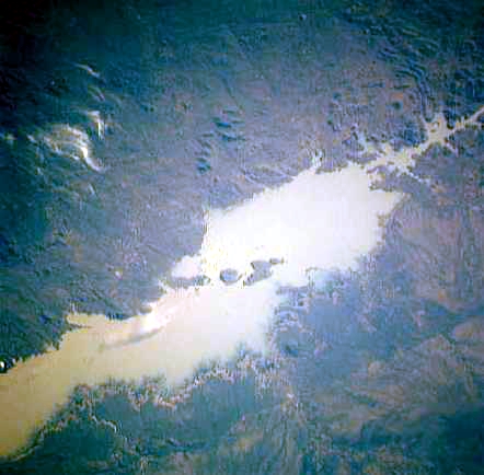
Lago de Cahora Bassa
Reservoir · 1,556 km²
Lago de Cahora Bassa is an artificial reservoir in Mozambique, with a mapped surface area of about 1,556 km². It exists because of a dam rather than natural drainage, and was filled in 1974.
The Cahora Bassa lake—in the Portuguese colonial era (until 1974) known as Cabora Bassa, from Nyungwe Kahoura-Bassa, meaning "finish the job"—is Africa's fourth-largest artificial lake, situated in the Tete Province in Mozambique. In Africa, only Lake Volta in Ghana, Lake Kariba on the Zambezi upstream of Cahora Bassa, and Egypt's Lake Nasser are bigger in terms of surface water.
Adapted from Wikipedia: Cahora Bassa (CC BY-SA 4.0).
- Surface area
- 1,556 km²
- Area rank
- #129 of 756 indexed
- Type
- Reservoir
- Country
- Mozambique
- Impounded
- 1974
- Coordinates
- -15.6474°, 32.1299°
Among the 756 water bodies with a mapped extent in YearMaps, Lago de Cahora Bassa ranks #129 by surface area, after Lago Poopó (1,558 km²) and ahead of Har Us Nuur (1,549 km²). Areas are computed from the mapped outline and are approximate.
- Other water nearby:
- Lake Malawi (28,974 km²), Lake Kariba (4,724 km²)
More about Lago de Cahora Bassa
History
The Cahora Bassa System started in the late 1960s as a project of the Portuguese in the Overseas Province of Mozambique. Southern African governments were also involved in an agreement stating that Portugal would build and operate a hydroelectric generating station at Cabora Bassa (as it was then called in Portuguese) together with the high-voltage direct current (HVDC) transmission system required to bring electricity to the border of South Africa. South Africa, on the other hand, undertook to build and operate the Apollo converter station and part of the transmission system required to bring the electricity from the South African-Mozambican border to the Apollo converter station near Pretoria. South Africa was then obliged to buy electricity that Portugal was obliged to supply.
Sections adapted from Wikipedia: Cahora Bassa (CC BY-SA 4.0).
Lago de Cahora Bassa: Key Facts
| Surface area | 2,739 km² |
|---|---|
| Inflows | Zambezi River, Manyame River |
| Outflows | Zambezi River |
| Drainage system | Zambezi Basin |
Facts from Wikidata Q755015 (CC0).
Rivers in Mozambique
12 rivers recorded. Listed alphabetically. A river is listed where its mapped reach lies, so long rivers appear under more than one country.
Ports in Mozambique
6 ports recorded. Ranked by approach channel depth, the figure that limits which ships can call. Harbours link to their write-up on the page of the sea or coast they lie on.
| # | Name | Channel Depth | Class | Sea | Max Vessel |
|---|---|---|---|---|---|
| 1 | Chinde | 56.7 m | Small | East & Southern Africa | medium vessels |
| 2 | Porto Belo | 53 m | Small | East & Southern Africa | medium vessels |
| 3 | Quelimane | 53 m | Very Small | East & Southern Africa | medium vessels |
| 4 | Beira | 49.4 m | Minor | East & Southern Africa | medium vessels |
| 5 | Pebane | 42.1 m | Small | East & Southern Africa | medium vessels |
| 6 | Ibo | 38.4 m | Very Small | East & Southern Africa | point_of_interest |
UNESCO World Heritage Sites in Mozambique
2 World Heritage Sites recorded. Listed by year of inscription, earliest first. Sites shared with another country appear under each.
| # | Name | Inscribed | Type | Criteria |
|---|---|---|---|---|
| 1 | Island of Mozambique | 1991 | Cultural | (iv) (vi) |
| 2 | iSimangaliso Wetland Park | 1999 | Natural | (vii) (ix) (x) |
Mountain Ranges, Deserts and Landforms of Mozambique
5 mountain ranges, deserts and other landforms recorded. Ranked by mapped area. Covers mountain ranges, deserts, plateaus, named glaciers, plains, basins, peninsulas and capes. One that crosses a border is listed under every country it lies in, with the area of the whole feature.
| # | Name | Area | Type | Region |
|---|---|---|---|---|
| 1 | Africa | 29.41M km² | Continent | Africa |
| 2 | Great Rift Valley | 163,247 km² | Valley | Africa |
| 3 | Inyanga Mountains | 58,492 km² | Range/mtn | Africa |
| 4 | Lebombo Mountains | 17,406 km² | Range/mtn | Africa |
| 5 | Zambezi Delta | 15 km² | Delta | Africa |
States and Provinces of Mozambique
3 first-level divisions with their own map.
Countries Bordering Mozambique
Land and maritime neighbours.
More Maps in Africa
Mozambique: Quick Answers
- What is the capital of Mozambique?
- The capital of Mozambique is Maputo.
- What is the population of Mozambique?
- Mozambique has a population of about 35.63 million, the #46 largest of 225 countries in YearMaps. Source: World Bank, 2025.
- How big is Mozambique?
- Mozambique covers 801,590 km², ranking #37 by area, with about 44 people per square kilometre.
- Which continent is Mozambique in?
- Mozambique is in Africa.
- Which countries border Mozambique?
- Mozambique shares a land or maritime border with South Africa, Tanzania, Zambia, Zimbabwe, Comoros, Malawi, Swaziland.
- What is the largest city in Mozambique?
- Maputo is the largest city in Mozambique, with a metropolitan population of about 1.45 million.
- What is the highest mountain in Mozambique?
- The highest summit recorded for Mozambique in YearMaps is Mount Binga at 2,436 m (7,992 ft). Summits on a border are counted for both countries.
- What is the largest lake in Mozambique?
- The largest lake recorded in or bordering Mozambique is Lake Malawi, at roughly 28,974 km².
- What is the tallest dam in Mozambique?
- The tallest dam recorded for Mozambique is Cahora Bassa Dam at 171 m, on the Zambezi.