
Map of Kenya
Kenya is a country in Africa with its capital at Nairobi, home to about 57.53 million people across 581,309 km². The interactive map below plots 36 cities and towns, 1 rivers, 4 lakes, 3 mountain summits and 2 ports recorded for Kenya in YearMaps.
- Population
- 57.53 million
- Area
- 581,309 km²
- Capital
- Nairobi
- Continent
- Africa
Interactive Map of Kenya
Centred on Nairobi at 1.2814° S, 36.8147° E. Use the layer panel to switch on rivers, dams, ports, peaks and historical borders.
About Kenya
Kenya, officially the Republic of Kenya, is a country located in East Africa. With an estimated population of more than 54.2 million as of mid-2026, it is the 26th-most populous country in the world and the seventh-most populous in Africa. Kenya's capital and largest city is Nairobi. The second-largest and oldest city is Mombasa, a port city located on Mombasa Island. Other major cities within the country include Kisumu, Nakuru and Eldoret. Going clockwise, Kenya is bordered by South Sudan to the northwest, Ethiopia to the north, Somalia to the east, the Indian Ocean to the southeast, Tanzania to the southwest, and Lake Victoria and Uganda to the west. Its geography, climate and population vary. In western Rift Valley counties, the landscape includes cold, snow-capped mountaintops (such as Batian, Nelion, and Point Lenana on Mount Kenya) with surrounding forests, wildlife, and fertile agricultural regions in temperate climates. In other areas there are dry, arid, and semi-arid climates, as well as absolute deserts (such as the Chalbi Desert and Nyiri Desert).
Kenya's earliest inhabitants included some of the first humans to evolve from ancestral members of the genus Homo. Ample fossil evidence for this evolutionary history has been found at Koobi Fora. Later, Kenya was inhabited by hunter-gatherers similar to the present-day Hadza people. According to archaeological dating of associated artefacts and skeletal material, Cushitic speakers first settled in the region's lowlands between 3,200 and 1,300 BC, a phase known as the Lowland Savanna Pastoral Neolithic. Nilotic-speaking pastoralists (ancestral to Kenya's Nilotic speakers) began migrating from present-day South Sudan into Kenya around 500 BC. Bantu people settled at the coast and the interior between 250 BC and 500 AD. European contact began in 1500 AD with the Portuguese Empire, and effective colonisation of Kenya began in the 19th century during the European exploration of Africa. Modern-day Kenya emerged from a protectorate, established by the British Empire in 1895, and the subsequent Kenya Colony, which began in 1920. Mombasa was the capital of the British East Africa Protectorate, which included most of what is now Kenya and southwestern Somalia, from 1889 to 1907. Disputes between the UK and the colony led to the Mau Mau revolution, which began in 1952, and the declaration of Kenya's independence in 1963. After independence, Kenya remained a member of the Commonwealth of Nations.
Summary adapted from Wikipedia: Kenya (CC BY-SA 4.0).

Geography and Climate of Kenya
Trade centers such as Mombasa have existed along the Kenyan and Tanzanian coastlines, known as the Land of Zanj, since at least the 2nd century. These centers traded with the outside world, including China, India, Indonesia, the Middle East, North Africa, and Persia. By around the 9th century, the mix of Africans, Arabs, and Persians who lived and traded there became known as Swahili ("people of the coast") with a distinct language (KiSwahili) and culture. The Portuguese arrived in the 1490s and, using Mombasa as a base, sought to monopolize trade in the Indian Ocean. The Portuguese were pushed out in the late 1600s by the combined forces of Oman and Pate, an island off the coast. In 1890, Germany and the UK divided up the region, with the UK taking the north and the Germans the south, including present-day Tanzania, Burundi, and Rwanda. In 1895, the British established the East Africa Protectorate, which in 1920 was converted into a colony, and named Kenya after its highest mountain. Numerous political disputes between the colony and the UK led to the violent Mau Mau Uprising, which began in 1952, and the eventual declaration of independence in 1963. Jomo KENYATTA, the founding president and an icon of the liberation struggle, led Kenya from independence in 1963 until his death in 1978, when Vice President Daniel Arap MOI took power in a constitutional succession. The country was a de facto one-party state from 1969 until 1982, after which time the ruling Kenya African National Union (KANU) changed the constitution to make itself the sole legal political party. MOI gave in to internal and external pressure for political liberalization in 1991, but the ethnically fractured opposition failed to dislodge KANU from power in elections in 1992 and 1997, which were marred by violence and fraud. MOI stepped down in 2002 after fair and peaceful elections. Mwai KIBAKI, running as the candidate of the multiethnic, united opposition group, the National Rainbow Coalition (NARC), defeated KANU candidate Uhuru KENYATTA, the son of the founding president, and assumed the presidency following a campaign centered on an anticorruption platform. Opposition candidate Raila ODINGA challenged KIBAKI's reelection in 2007 on the grounds of widespread vote rigging, leading to two months of ethnic violence that caused more than 1,100 deaths and displaced hundreds of thousands. African Union-sponsored mediation resulted in a power-sharing accord that brought ODINGA into the government as prime minister and outlined a reform agenda. In 2010, Kenyans overwhelmingly voted to adopt a new constitution that eliminated the prime minister, introduced additional checks and balances to executive power, and devolved power and resources to 47 newly created counties. Uhuru KENYATTA won the first presidential election under the new constitution in 2013. He won a second and final term in office in 2017 after a contentious repeat election. In 2022, William RUTO won a close presidential election; he assumed the office the following month after the Kenyan Supreme Court upheld the victory.
- Location
- Eastern Africa, bordering the Indian Ocean, between Somalia and Tanzania.
- Climate
- Varies from tropical along coast to arid in interior.
- Terrain
- Low plains rise to central highlands bisected by Great Rift Valley; fertile plateau in west.
- Highest point
- Mount Kenya 5,199 m.
- Lowest point
- Indian Ocean 0 m.
- Coastline
- 536 km.
- Land borders
- Total: 3,457 km; border countries: Ethiopia 867 km; Somalia 684 km; South Sudan 317 km; Tanzania 775 km; Uganda 814 km.
- Major lakes
- Fresh water lake(s): Lake Victoria (shared with Tanzania and Uganda) - 62,940 sq km; salt water lake(s): Lake Turkana (shared with Ethiopia) - 6,400 sq km.
- Natural resources
- Limestone, soda ash, salt, gemstones, fluorspar, zinc, diatomite, gypsum, wildlife, hydropower.
- Land use
- Agricultural land: 49.5% (2023 est.); arable land: 11.4% (2023 est.); permanent crops: 1.4% (2023 est.); permanent pasture: 36.7% (2023 est.); forest: 6.5% (2023 est.); other: 44% (2023 est.)
- Natural hazards
- Recurring drought; flooding during rainy seasons volcanism: limited volcanic activity; the Barrier (1,032 m) last erupted in 1921; South Island is the only other historically active volcano.
- Geographic note
- The Kenyan Highlands comprise one of the most successful agricultural production regions in Africa; glaciers are found on Mount Kenya, Africa's second-highest peak; unique physiography supports abundant and varied wildlife of scientific and economic value; Lake Victoria, the world's largest tropical lake and the second-largest freshwater lake, is shared among three countries: Kenya, Tanzania, and Uganda.
- Languages
- English (official), Kiswahili (official), numerous indigenous languages.
- Religions
- Christian 85.5% (Protestant 33.4%, Catholic 20.6%, Evangelical 20.4%, African Instituted Churches 7%, other Christian 4.1%), Muslim 10.9%, other 1.8%, none 1.6%, don't know/no answer 0.2% (2019 est.)
- Ethnic groups
- Kikuyu 17.1%, Luhya 14.3%, Kalenjin 13.4%, Luo 10.7%, Kamba 9.8%, Somali 5.8%, Kisii 5.7%, Mijikenda 5.2%, Meru 4.2%, Maasai 2.5%, Turkana 2.1%, non-Kenyan 1%, other 8.2% (2019 est.)
- Economy
- Fast growing, third largest Sub-Saharan economy; strong agriculture sector with emerging services and tourism industries; IMF program to address current account and debt service challenges; business-friendly policies foster infrastructure investment, digital innovation and public-private partnerships; vulnerable to climate change-induced droughts.
From the CIA World Factbook (public domain), archived edition of 2026-01-22. The Factbook is no longer updated, so figures reflect that edition.
Kenya in Numbers
- Population
- 57.53 million
- GDP
- US$135.9 billion
- GDP per person
- US$2,363
- Life expectancy
- 63.8 years
- Population growth
- 1.93% a year
- Population density
- 97 per km²
- Urban population
- 32.2%
- Surface area
- 591,970 km²
- Forest cover
- 6.6%
- Arable land
- 11.5%
- Access to electricity
- 77.0%
- Internet users
- 35.0%
Indicators from World Bank Open Data (CC BY 4.0). The year under each figure is its reference year.
Kenya in Depth
History
Hominid species, such as Homo habilis (fl. 1.8 to 2.5 million years ago) and Homo erectus (fl. 1.9 million to 350,000 years ago), possibly the direct ancestors of modern Homo sapiens, had lived in Kenya in the Pleistocene epoch. East Africa, including Kenya, is one of the earliest regions where modern humans (Homo sapiens) are believed to have lived. In 1984, during excavations at Lake Turkana palaeoanthropologist Richard Leakey, assisted by Kamoya Kimeu, discovered the Turkana Boy, a 1.6-million-year-old Homo erectus fossil.
Geography
At 580,367 km2 (224,081 sq mi), Kenya is the world's 47th-largest country (after Madagascar). It lies between latitudes 5°N and 5°S, and longitudes 34° and 42°E. From the coast on the Indian Ocean, the low plains rise to central highlands which are bisected by the Great Rift Valley, and fertile plateaus lie on either side, around Lake Victoria and to the east.
The Kenyan Highlands are one of the most successful agricultural production regions in Africa. The highlands are the site of the highest point in Kenya and the second highest peak on the continent: Mount Kenya, which reaches a height of 5,199 m (17,057 ft) and is the site of glaciers. Mount Kilimanjaro (5,895 m or 19,341 ft) can be seen from Kenya to the south of the Tanzanian border.
Economy
Kenya's macroeconomic outlook has steadily posted robust growth over the past few decades mostly from road, rail, air and water transport infrastructure projects as well as massive investments in Information and Communication Technology. The Kenyan economy is the largest in East Africa. After independence, Kenya promoted rapid economic growth through public investment, encouraged smallholder agricultural production and provided incentives for private industrial investment. Kenya is East Africa's regional transportation and financial hub. Kenya's financial sector is vibrant, well developed and diversified boasting the highest financial inclusion in the region and globally.
Foreign investments in Kenya remain relatively weak considering the size of its economy and its level of development.
Demographics
The census carried out by the Kenya National Bureau of Statistics in 2019 reported Kenya's population as 47,564,296. The country has a young population, with 73% of residents under 30 because of rapid population growth, from 2.9 million to 40 million inhabitants over the last century.
Nairobi is home to Kibera, one of the world's largest slums. The shantytown is believed to house between 170,000 and one million people. The UNHCR base in Dadaab in the north houses around 500,000.
Kenya has a diverse population that includes many of Africa's major ethnoracial and linguistic groups.
Sections adapted from Wikipedia: Kenya (CC BY-SA 4.0).
Kenya: Key Facts
| Currency | Kenyan shilling |
|---|---|
| Official languages | Swahili, English |
| Head of state | William Ruto |
| Head of government | William Ruto |
| Calling code | +254 |
| Internet domain | .ke |
| Highest point | Mount Kenya |
| Lowest point | Indian Ocean |
| Established | 1963 |
Facts from Wikidata Q114 (CC0).
History of Kenya: Empires and States
The atlas records 4 polities whose mapped territory included part of Kenya, from British Africa in 1890 CE to 2024 CE. They are listed in the order they first appear.
| Polity | Period here | Extent |
|---|---|---|
| British Africa | 1890–1960 CE | Most |
| The British Empire | 1890–1962 CE | Most |
| British East Africa | 1961–1968 CE | Most |
| Republic of Kenya | 1963–2024 CE | Most |
Historical Maps of Kenya
Kenya on the world map in each year one of these states held it:
Derived by testing mapped cities against dated territorial polygons. Dates are when the polygons cover this place, not the polity's whole lifespan, and polities absent from the source dataset are not listed.
Visiting Kenya
Kenya in East Africa is a pearl in sub-Saharan Africa. From the scenic sandy beaches at the coast, to the Nairobi National Park, to the majestic Rift Valley, the bird life in Lake Naivasha, the hot boiling springs of Lake Baringo, Lake Turkana and Lake Victoria, Kenya is a very beautiful country with lots of wildlife and scenic features, and is one of the major economic hubs in Africa. Fondly referred to as the "Jewel of Africa", Kenya is a dream destination for its Swahili heritage and the home of humankind and Safari industry.
Travel notes adapted from Wikivoyage: Kenya (CC BY-SA 4.0).
Largest Cities in Kenya
36 cities recorded. Ranked by metropolitan population. A port city's harbour is written up on the page of its sea.
| # | Name | Population | Region | Role |
|---|---|---|---|---|
| 1 | Nairobi | 3.01 million | Nairobi | National capital |
| 2 | Mombasa | 882,000 | Coast | Admin-1 capital |
| 3 | Kisumu | 395,615 | Nyanza | Admin-1 capital |
| 4 | Nakuru | 364,727 | Rift Valley | Admin-1 capital |
| 5 | Eldoret | 353,381 | Rift Valley | Populated place |
| 6 | Kitale | 150,495 | Rift Valley | Populated place |
| 7 | Machakos | 144,925 | Eastern | Populated place |
| 8 | Thika | 99,322 | Central | Populated place |
| 9 | Kericho | 98,852 | Rift Valley | Populated place |
| 10 | Malindi | 94,016 | Coast | Populated place |
| 11 | Kendu Bay | 91,248 | Nyanza | Populated place |
| 12 | Kilifi | 80,339 | Coast | Populated place |
| 13 | Sotik | 71,285 | Rift Valley | Populated place |
| 14 | Garissa | 67,861 | North-Eastern | Populated place |
| 15 | Kakamega | 63,426 | Western | Admin-1 capital |
| 16 | Embu | 58,620 | Eastern | Admin-1 capital |
| 17 | Bungoma | 55,962 | Western | Populated place |
| 18 | Nyeri | 51,084 | Central | Admin-1 capital |
| 19 | Meru | 47,226 | Eastern | Populated place |
| 20 | Wajir | 45,771 | North-Eastern | Populated place |
| 21 | Naivasha | 43,983 | Rift Valley | Populated place |
| 22 | Voi | 36,487 | Coast | Populated place |
| 23 | Nanyuki | 36,142 | Rift Valley | Populated place |
| 24 | Kisii | 28,547 | Nyanza | Populated place |
| 25 | Moyale | 24,837 | Eastern | Populated place |
The other 11 (population, region, role)
- Lamu · 24,525 · Coast · Populated place
- Maralal · 20,841 · Rift Valley · Populated place
- Lodwar · 20,219 · Rift Valley · Populated place
- Eldama Ravine · 17,581 · Rift Valley · Populated place
- Marsabit · 16,460 · Eastern · Populated place
- Namanga · 13,193 · Rift Valley · Populated place
- Mwingi · 11,219 · Eastern · Populated place
- Witu · 5,380 · Coast · Populated place
- Karungu · 2,376 · Nyanza · Populated place
- Konza · 2,004 · Rift Valley · Populated place
- Tsavo · 414 · Coast · Populated place
Highest Mountains in Kenya
3 mountains recorded. Ranked by summit elevation above sea level. A summit on a border is listed under both countries.
| # | Name | Elevation | Feet | Region |
|---|---|---|---|---|
| 1 | Mount Kenya | 5,199 m | 17,057 ft | Africa |
| 2 | Mount Elgon | 4,321 m | 14,177 ft | Africa |
| 3 | Lesatima | 4,001 m | 13,127 ft | Africa |

Mount Kenya
Mountain · 5,199 m
Mount Kenya is a mountain rising to 5,199 metres (17,057 ft) in Kenya, in the Africa region.
Mount Kenya (Meru: Kĩrĩmaara, Kikuyu: Kĩrĩmanyaga, or "Kīrī-nyaga", Kamba: Ki nyaa, Embu: Kĩ nyaga, or "Kirinyaga") is the second highest mountain in Africa and the namesake of the country Kenya. Located about 150 km (90 mi) north-northeast of the capital of Nairobi and just 16.5 kilometres (10.3 miles) south of the equator, the mountain's highest peaks are Batian (5,199 m), Nelion (5,188 m), and Point Lenana (4,985 m). Historically situated in the former Eastern and Central provinces, the massif now serves as the intersection of Meru, Embu, Kirinyaga, Nyeri, and Tharaka Nithi counties. The area was officially gazetted as the Mount Kenya National Park in 1949 and was later designated a UNESCO World Heritage Site in 1997 for its outstanding natural beauty and ecological significance. Today, the park and its surrounding forest reserve are managed by the Kenya Wildlife Service and the Kenya Forest Service as a critical sanctuary for endangered species and a primary water tower for the region.
Mount Kenya is a volcano created approximately 3 million years after the opening of the East African Rift. Before glaciation, it was 7,000 m (23,000 ft) high.
Adapted from Wikipedia: Mount Kenya (CC BY-SA 4.0).
- Elevation
- 5,199 m (17,057 ft)
- Global rank
- #58 of 641 indexed
- Region
- Africa (#2)
- Country
- Kenya
- Coordinates
- -0.1501°, 37.2999°
Of the 641 named summits indexed in YearMaps, Mount Kenya ranks #58 by elevation, below Gora Shkhara (5,200 m) and above Mount Ararat (5,137 m).
- Ranges:
- Ruwenzori Range (Africa), Ethiopian Highlands (Africa)
- Neighbouring summits:
- Lesatima (4,001 m), Mount Kilimanjaro (5,895 m), Mount Elgon (4,321 m)
More about Mount Kenya
Geology
Mount Kenya is a stratovolcano that was active in the Plio-Pleistocene. The original crater was probably over 6,000 m (19,700 ft) high; and potentially up to 7,000 m (23,000 ft) high, making the prehistoric Mount Kenya higher than present-day Kilimanjaro. Since it became extinct there have been two major periods of glaciation, which are shown by two main rings of moraines below the glaciers. The lowest moraine is found at around 3,300 m (10,800 ft). Today the glaciers reach no lower than 4,650 m (15,260 ft). After studying the moraines, John Walter Gregory put forward the theory that at one time the whole summit of the mountain was covered with an ice cap, and it was this that eroded the peaks to how they are today.
Natural history
Mount Kenya has several altitudinal ecological zones, from the savanna surrounding the mountain to the nival zone by the glaciers. Each zone has a dominant species of vegetation. Many of the species found higher up the mountain are endemic, either to Mount Kenya or East Africa.
There are also differences within the zones, depending on the side of the mountain and the aspect of the slope. The southeast is much wetter than the north, so species more dependent on moisture can grow. Some species, such as African alpine bamboo, are limited to certain aspects of the mountain because of the amount of moisture.
The climate of Mount Kenya changes considerably with altitude, forming belts of community types. Around the base of the mountain is fertile farmland.
Climate
The climate of Mount Kenya has played a critical role in the development of the mountain, influencing the topography and ecology amongst other factors. It has a typical equatorial mountain climate which Hedberg described as winter every night and summer every day. Mount Kenya is home to one of the Global Atmosphere Watch's atmospheric monitoring stations.
The year is divided into two distinct wet seasons and two distinct dry seasons which mirror the wet and dry seasons in the Kenyan lowlands. As Mount Kenya ranges in height from 1,374 to 5,199 m (4,508 to 17,057 ft), the climate varies considerably over the mountain and has different zones of influence. The lower, southeastern slopes are the wettest as the predominant weather system comes from the Indian Ocean.
Sections adapted from Wikipedia: Mount Kenya (CC BY-SA 4.0).
Mount Kenya: Key Facts
| Topographic prominence | 3,825 m |
|---|---|
| Mountain range | Mount Kilimanjaro |
Facts from Wikidata Q172070 (CC0).

Mount Elgon
Mountain · 4,321 m
Mount Elgon is a mountain rising to 4,321 metres (14,177 ft) in Uganda and Kenya, in the Africa region. The summit stands on the border between them.
Mount Elgon is an extinct shield volcano on the border of Uganda and Kenya, north of Kisumu, east of Mbale and west of Kitale. The mountain's highest point, named "Wagagai", is located entirely within Uganda. Although there is no verifiable evidence of its earliest volcanic activity, geologists estimate that Mount Elgon is at least 24 million years old, making it the oldest known extinct volcano in East Africa. The mountain's name originates from its Maasai name, “Ol Doinyo Ilgoon” (Breast Mountain).
Adapted from Wikipedia: Mount Elgon (CC BY-SA 4.0).
- Elevation
- 4,321 m (14,177 ft)
- Global rank
- #98 of 641 indexed
- Region
- Africa (#7)
- Countries
- Uganda, Kenya
- Coordinates
- 1.1232°, 34.5342°
Of the 641 named summits indexed in YearMaps, Mount Elgon ranks #98 by elevation, below Mount Shasta (4,322 m) and above Mount Batu (4,307 m).
- Ranges:
- Ruwenzori Range (Africa), Ethiopian Highlands (Africa)
- Neighbouring summits:
- Lesatima (4,001 m), Mount Kenya (5,199 m)
More about Mount Elgon
Mount Elgon: Key Facts
| Topographic prominence | 2,458 m |
|---|
Facts from Wikidata Q732838 (CC0).
Lesatima
Mountain · 4,001 m
Lesatima is a mountain rising to 4,001 metres (13,127 ft) in Kenya, in the Africa region.
Mount Satima, also known as Mount Lesatima and often abbreviated to Satima or Lesatima, is the third-highest mountain in Kenya and the highest in the Aberdare Range. The Maasai name is Oldoinyo Lesatima, which has a variety of alternative spellings, such as Ol Donyo Le Satima, and means "mountain of the bull calf".
The peak lies at the northern end of the Aberdares, which themselves are along the eastern side of the Great Rift Valley, and is their highest point. Around it stand a number of sharp volcanic cones called "the Dragon's Teeth". There are moraines between 3,600 metres (11,800 ft) and 3,800 metres (12,500 ft) on the north west of the mountain. One book on Kenya has called the mountain itself "a craggy bluff of rock and tussock grass around which the clouds swirl".
Adapted from Wikipedia: Mount Satima (CC BY-SA 4.0).
- Elevation
- 4,001 m (13,127 ft)
- Global rank
- #126 of 641 indexed
- Region
- Africa (#12)
- Country
- Kenya
- Coordinates
- -0.3248°, 36.6236°
Of the 641 named summits indexed in YearMaps, Lesatima ranks #126 by elevation, below Mount Waddington (4,019 m) and above Otgon Tenger (4,000 m).
- Ranges:
- Ruwenzori Range (Africa), Ethiopian Highlands (Africa)
- Neighbouring summits:
- Mount Kenya (5,199 m), Mount Elgon (4,321 m), Loolmalasin (3,682 m)
More about Lesatima
Lesatima: Key Facts
| Topographic prominence | 2,081 m |
|---|---|
| Mountain range | Aberdare Range |
Facts from Wikidata Q6923490 (CC0).
Largest Lakes in Kenya
4 lakes recorded. Ranked by mapped surface area. A lake on a border is listed under each country it lies in, with the area of the whole lake.
| # | Name | Surface Area | Type |
|---|---|---|---|
| 1 | Lake Victoria | 69,385 km² | Lake |
| 2 | Lake Turkana | 7,747 km² | Alkaline Lake |
| 3 | Chew Bahir | 755 km² | Alkaline Lake |
| 4 | Masinga Res | 203 km² | Lake |

Lake Victoria
Lake · 69,385 km²
Lake Victoria is a lake in Tanzania, Uganda and Kenya, with a mapped surface area of about 69,385 km². About 6% of its surface lies in Kenya, and the rest in Tanzania and Uganda.
Lake Victoria is one of the African Great Lakes. With a surface area of approximately 59,947 km2 (23,146 sq mi), Lake Victoria is Africa's largest lake by area, the world's largest tropical lake, and the world's second-largest fresh water lake by surface area after Lake Superior in North America. In terms of volume, Lake Victoria is the world's ninth-largest continental lake, containing about 2,424 km3 (1.965×10⁹ acre⋅ft) of water. Lake Victoria occupies a shallow depression in Africa. The lake has an average depth of 40 m (130 ft) and a maximum depth of 80–81 m (262–266 ft). Its catchment area covers 169,858 km2 (65,583 sq mi). The lake has a shoreline of 7,142 km (4,438 mi) when digitized at the 1:25,000 level, with islands constituting 3.7% of this length.
The lake's area is divided among three countries: Tanzania occupies 49% (33,700 km2 (13,000 sq mi)), Uganda 45% (31,000 km2 (12,000 sq mi)), and Kenya 6% (4,100 km2 (1,600 sq mi)).
The lake is home to many species of fish which live nowhere else, especially cichlids. Invasive fish, such as the Nile perch, have driven many endemic species to extinction.
Adapted from Wikipedia: Lake Victoria (CC BY-SA 4.0).
- Surface area
- 69,385 km²
- Area rank
- #3 of 756 indexed
- Type
- Lake
- Countries
- Tanzania, Uganda, Kenya
- Coordinates
- -0.7956°, 33.2197°
Among the 756 water bodies with a mapped extent in YearMaps, Lake Victoria ranks #3 by surface area, after Lake Superior (84,920 km²) and ahead of Lake Huron (64,004 km²). Areas are computed from the mapped outline and are approximate.
- Watercourses:
- Victoria Nile (River), Kagera (River)
- Other water nearby:
- Lake Turkana (7,747 km²), Chew Bahir (755 km²)
More about Lake Victoria
Hydrology and limnology
Lake Victoria receives 80 percent of its water from direct rainfall. Average evaporation on the lake is between 2.0 and 2.2 metres (6 ft 7 in and 7 ft 3 in) per year, almost double the precipitation of riparian areas. Lake Victoria receives its water additionally from rivers, and thousands of small streams. The Kagera River is the largest river flowing into this lake, with its mouth on the lake's western shore. Lake Victoria is drained solely by the Nile River near Jinja, Uganda, on the lake's northern shore.
In the Kenya sector, the main influent rivers are the Sio, Nzoia, Yala, Nyando, Sondu Miriu, Mogusi, and Migori. The only outflow from Lake Victoria is the Nile River, which exits the lake near Jinja, Uganda.
Geology
Photojournalist John Reader, writing in his Alan Paton Literary Award-winning Africa: A Biography of a Continent, describes Lake Victoria as being relatively geologically young at about 400,000 years old—having been formed as westward-flowing rivers were backed up "when a fractured block of the Earth's crust tilted along the line of the Great Rift Valley, raising its western edge". A primary study, attempting "fluvial differentiation of the basin of Lake Victoria", draws several relevant tentative conclusions.
History and exploration
The first recorded information about Lake Victoria comes from Arab traders plying the inland routes in search of gold, ivory, other precious commodities, and slaves.
Many Africans tribes lived in the catchment area around the lake. It was first sighted by a European in 1858 when the British explorer John Hanning Speke reached its southern shore while on his journey with Richard Francis Burton to explore central Africa and locate the Great Lakes. Believing he had found the source of the Nile on seeing this "vast expanse of open water" for the first time, Speke named the lake after Queen Victoria.
Sections adapted from Wikipedia: Lake Victoria (CC BY-SA 4.0).
Lake Victoria: Key Facts
| Surface area | 68,100 km² |
|---|---|
| Maximum depth | 83 m |
| Volume | 2,750 km³ |
| Surface elevation | 1,133 m |
| Inflows | Kagera River, Mogusi River, Nyando River, Yala River, Gucha River, Sondu Miriu |
| Outflows | White Nile |
| Drainage system | Nile basin |
Facts from Wikidata Q5505 (CC0).

Lake Turkana
Alkaline Lake · 7,747 km²
Lake Turkana is a alkaline lake in Kenya and Ethiopia, with a mapped surface area of about 7,747 km². About 94% of its surface lies in Kenya, and the rest in Ethiopia.
Lake Turkana () is a saline lake in the Kenyan Rift Valley, predominantly in northern Kenya; the far northern end crosses into Ethiopia. It is the world's largest permanent desert lake and the world's largest alkaline lake. By volume it is the world's fourth-largest salt lake after the Caspian Sea, Issyk-Kul, and Lake Van (passing the shrinking South Aral Sea), and among all lakes it ranks 22nd.
Lake Turkana is now threatened by the construction of the Gilgel Gibe III Dam in Ethiopia due to the damming of the Omo River which supplies most of the lake's water.
Although the lake commonly has been—and to some degree still is—used for drinking water, its salinity (slightly brackish) and very high levels of fluoride (much higher than in fluoridated water) generally make it unsuitable for drinking; it has also been a source of diseases spread by contaminated water. Increasingly, communities around the lake rely on underground springs for drinking water. The same characteristics that make it unsuitable for drinking limit its use for irrigation. The climate is hot and very dry.
The rocks of the surrounding area are predominantly volcanic.
Adapted from Wikipedia: Lake Turkana (CC BY-SA 4.0).
- Surface area
- 7,747 km²
- Area rank
- #27 of 756 indexed
- Type
- Alkaline Lake
- Countries
- Kenya, Ethiopia
- Coordinates
- 3.7715°, 36.0494°
Among the 756 water bodies with a mapped extent in YearMaps, Lake Turkana ranks #27 by surface area, after Lake Athabasca (8,047 km²) and ahead of Reindeer Lake (6,875 km²). Areas are computed from the mapped outline and are approximate.
- Other water nearby:
- Chew Bahir (755 km²), Lake Victoria (69,385 km²)
More about Lake Turkana
Geology
Lake Turkana is an East African Rift feature. A rift is a weak place in the Earth's crust due to the separation of two tectonic plates, often accompanied by a graben, or trough, in which lake water can collect. The rift began when East Africa, impelled by currents in the mantle, began separating from the rest of Africa, moving to the northeast. Currently, the graben is 320 km wide in the north of the lake, 170 km in the south. This rift is one of two, and is called the Great or Eastern Rift. There is another to the west, the Western Rift.
Lake Turkana is a unique feature of the East African landscape. Besides being a permanent desert lake, it is the only lake that retains water originating from two separate catchment areas of the Nile.
Sections adapted from Wikipedia: Lake Turkana (CC BY-SA 4.0).
Lake Turkana: Key Facts
| Surface area | 6,405 km² |
|---|---|
| Maximum depth | 109 m |
| Surface elevation | 360 m |
| Inflows | Omo River, Turkwel River, Kibish River, Kerio River |
| Outflows | evaporation |
Facts from Wikidata Q182719 (CC0).
Chew Bahir
Alkaline Lake · 755 km²
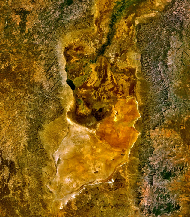
Chew Bahir is a alkaline lake in Ethiopia and Kenya, with a mapped surface area of about 755 km².
Lake Chew Bahir (Amharic: ጨው ባሕር č̣ew bāhir, "salty lake") or Lake Istifanos, also called Stefanie, Basso Naebor and Chuwaha, is a lake in southern Ethiopia, located on the southwestern end of the South Ethiopia Regional State, near the border with Oromia Region.
Adapted from Wikipedia: Lake Chew Bahir (CC BY-SA 4.0).
- Surface area
- 755 km²
- Area rank
- #238 of 756 indexed
- Type
- Alkaline Lake
- Countries
- Ethiopia, Kenya
- Coordinates
- 4.6791°, 36.8660°
Among the 756 water bodies with a mapped extent in YearMaps, Chew Bahir ranks #238 by surface area, after Lac Minto (765 km²) and ahead of Sasyqkl (750 km²). Areas are computed from the mapped outline and are approximate.
- Other water nearby:
- Lake Turkana (7,747 km²), Lake Victoria (69,385 km²)
More about Chew Bahir
Geography
When the Lake Chew Bahir is filled, it stretches into northern Kenya. Lying at the center of the Stephanie Wildlife Sanctuary, the lake measures some 40 by 15 miles (64 by 24 km).
This lake is the southernmost and lowest (1,880 ft; 570 m) of a series of lakes which lie in the north-easterly continuation of the Great Rift Valley; its watershed is separated from the watershed of Lake Turkana by the Humu Range and the hills south of it. The Kumbi Range rises on its eastern side. Chew Bahir is fed from the north by the Weito River, and its tributary the Galana Sagan. The Galana Sagan receives the overflow of Lake Chamo in some years, but no permanent connection exists.
History
Count Sámuel Teleki was the first European to visit the lake in 1888, and named it for Princess Stéphanie of Belgium, the wife of Crown Prince Rudolf of Austria. Following Teleki's visit, Lake Chew Bahir and the neighboring lakes were explored by Arthur Donaldson Smith, Vittorio Bottego, M. S. Welby, Oscar Neumann and others. J. J. Harrison in 1899 found the lake quite dried up, and two years later Count Wickenburg found water only in the northern part. In 1960 the lake covered about 2,000 km2, but shrank to a swamp over the rest of the 20th century.
Sections adapted from Wikipedia: Lake Chew Bahir (CC BY-SA 4.0).
Chew Bahir: Key Facts
| Surface area | 1,200 km² |
|---|---|
| Surface elevation | 570 m |
| Inflows | Weito River |
Facts from Wikidata Q662811 (CC0).
Rivers in Kenya
1 river recorded. Listed alphabetically. A river is listed where its mapped reach lies, so long rivers appear under more than one country.
| Name | Type | Also Flows Through |
|---|---|---|
| Tana | Lake reach | — |
Ports in Kenya
2 ports recorded. Ranked by approach channel depth, the figure that limits which ships can call. Harbours link to their write-up on the page of the sea or coast they lie on.
UNESCO World Heritage Sites in Kenya
5 World Heritage Sites recorded. Listed by year of inscription, earliest first. Sites shared with another country appear under each.
| # | Name | Inscribed | Type | Criteria |
|---|---|---|---|---|
| 1 | Lake Turkana National Parks | 1997 | Natural | (viii) (x) |
| 2 | Mount Kenya National Park | 1997 | Natural | (vii) (ix) |
| 3 | Lamu Old Town | 2001 | Cultural | (ii) (iv) (vi) |
| 4 | Thimlich Ohinga | 2018 | Cultural | (iii) (iv) (v) |
| 5 | Ruins of Gedi | 2024 | Cultural | (ii) (iii) (iv) |
Mountain Ranges, Deserts and Landforms of Kenya
4 mountain ranges, deserts and other landforms recorded. Ranked by mapped area. Covers mountain ranges, deserts, plateaus, named glaciers, plains, basins, peninsulas and capes. One that crosses a border is listed under every country it lies in, with the area of the whole feature.
| # | Name | Area | Type | Region |
|---|---|---|---|---|
| 1 | Africa | 29.41M km² | Continent | Africa |
| 2 | Serengeti Plains | 99,080 km² | Plain | Africa |
| 3 | Great Rift Valley | 96,671 km² | Valley | Africa |
| 4 | Chalbi Desert | 95,914 km² | Desert | Africa |
States and Provinces of Kenya
4 first-level divisions with their own map.
Countries Bordering Kenya
Land and maritime neighbours.
More Maps in Africa
Kenya: Quick Answers
- What is the capital of Kenya?
- The capital of Kenya is Nairobi.
- What is the population of Kenya?
- Kenya has a population of about 57.53 million, the #26 largest of 225 countries in YearMaps. Source: World Bank, 2025.
- How big is Kenya?
- Kenya covers 581,309 km², ranking #50 by area, with about 99 people per square kilometre.
- Which continent is Kenya in?
- Kenya is in Africa.
- Which countries border Kenya?
- Kenya shares a land or maritime border with Ethiopia, Tanzania, South Sudan, Uganda, Somalia, Sudan.
- What is the largest city in Kenya?
- Nairobi is the largest city in Kenya, with a metropolitan population of about 3.01 million.
- What is the highest mountain in Kenya?
- The highest summit recorded for Kenya in YearMaps is Mount Kenya at 5,199 m (17,057 ft). Summits on a border are counted for both countries.
- What is the largest lake in Kenya?
- The largest lake recorded in or bordering Kenya is Lake Victoria, at roughly 69,385 km².