
Caroline Islands
Island group · 1.75M km²
Caroline Islands is an island group in Oceania (Micronesia), covering an estimated 1.75M km². It extends across Palau and Micronesia. It is the 6th-largest of the 445 islands with a mapped extent in YearMaps.
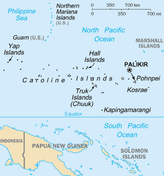
The Caroline Islands (or the Carolines) are a widely scattered archipelago of tiny islands in the western Pacific Ocean, to the north of New Guinea. Politically, they are divided between the Federated States of Micronesia (FSM) in the central and eastern parts of the group, and Palau at the extreme western end. Historically, this area was also called Nuevas Filipinas or New Philippines, because they were part of the Spanish East Indies and were governed from Manila in the Philippines.
The Carolines are scattered across a distance of approximately 3,540 kilometers (2,200 mi; 1,910 nmi), from the westernmost island, Tobi, in Palau, to the easternmost island, Kosrae, a state of the FSM.
Adapted from Wikipedia: Caroline Islands (CC BY-SA 4.0).
- Feature class
- Island group
- Mapped extent
- 1.75M km²
- Size rank
- #6 of 445 islands
- Region
- Oceania
- Subregion
- Micronesia
- Countries
- Palau, Micronesia
- Coordinates
- 4.3577°, 157.4944°
- Ranges:
- Owen Stanley Range (Oceania), New Guinea Highlands (Oceania)
- Settlements:
- Palikir (294 km)
More about Caroline Islands
History
Different islands in the Carolines have passed down different legends about the origins and early histories of their peoples. For example, on Pohnpei, the islanders describe their history before colonial times as divided into three eras: the Mwehin Kawa or Mwehin Aramas (era of building or peopling, before 1100); the Mwehin Sau Deleur (era of the reigns of the Saudeleur, from 1100 to around 1628); and the Mwehin Nahnmwarki (era of the tribal chiefs, from around 1628 to 1885, when Spain colonized the islands).
Description
The group consists of about 500 small coral islands, east of the Philippines, in the Pacific Ocean. The distance from Yap (one of the larger Caroline islands) to Manila is 1,200 mi (1,900 km).
Most of the islands are made up of low, flat coral atolls, but there are some that rise high above sea level.
Sections adapted from Wikipedia: Caroline Islands (CC BY-SA 4.0).
Caroline Islands: Key Facts
| Area | 1,160 km² |
|---|---|
| Population | 125,000 (2010) |
| Highest point | Dolohmwar |
| Surrounded by | Pacific Ocean |
Facts from Wikidata Q118350 (CC0).


