
Map of Equatorial Guinea
Equatorial Guinea is a country in Africa with its capital at Ciudad de la Paz, home to about 1.94 million people across 28,051 km². The interactive map below plots 6 cities and towns, 1 rivers, 2 mountain summits and 6 ports recorded for Equatorial Guinea in YearMaps.
- Population
- 1.94 million
- Area
- 28,051 km²
- Capital
- Ciudad de la Paz
- Continent
- Africa
Interactive Map of Equatorial Guinea
Centred on Ciudad de la Paz at 3.7500° N, 8.7833° E. Use the layer panel to switch on rivers, dams, ports, peaks and historical borders.
About Equatorial Guinea
Equatorial Guinea, officially the Republic of Equatorial Guinea, is a country on the west coast of Central Africa and the only Spanish-speaking country in Africa. It has an area of 28,000 square kilometres (11,000 sq mi). Formerly the colony of Spanish Guinea, its post-independence name refers to its location both near the Equator and in the African region of Guinea. As of 2025, the country has a population of 1,853,559, over 85% of whom are members of the Fang people, the country's dominant ethnic group. The Bubi people, indigenous to Bioko Island, are the second largest group at approximately 6.5% of the population. The capital, since January 2026, is Ciudad de la Paz, and Bata is the largest city.
Equatorial Guinea consists of two parts. The mainland region, Río Muni, is bordered by Cameroon to the north and Gabon to the south and east. It has the majority of the population. Río Muni's small offshore islands include Corisco, Elobey Grande, and Elobey Chico. The insular region consists of the islands of Bioko (formerly Fernando Po) in the Gulf of Guinea and Annobón. Bioko Island is the northernmost part of Equatorial Guinea and is the site of Malabo. The Portuguese-speaking island nation of São Tomé and Príncipe is located between Bioko and Annobón. The Equator runs through Equatorial Guinea's territorial waters, about 1.4° north of Annobón.
Pygmies are the first confirmed inhabitants to settle in the area of present-day Equatorial Guinea, followed by a migration of Bantu-speaking groups in the 6th century BC. Portuguese explorer Fernando Pó explored the area in 1472. Via the 1778 Treaty of El Pardo, Portugal ceded territories in the Bight of Biafra to Spain; the territory was declared Spanish Guinea during the Scramble for Africa. Nearly 200 years later, it gained independence in 1968 under the bloody dictatorship of President Francisco Macías Nguema. He declared himself president for life in 1972 but was overthrown in a coup in 1979 by his nephew, Teodoro Obiang Nguema Mbasogo, who has served as the country's president since. Obiang's regime has also been widely characterised as a dictatorship by foreign observers.
Since the mid-1990s, Equatorial Guinea has become one of Sub-Saharan Africa's largest oil producers. It has subsequently become one of the richest countries per capita in Africa; this wealth is extremely unevenly distributed, with few people benefiting from the oil riches.
Summary adapted from Wikipedia: Equatorial Guinea (CC BY-SA 4.0).

Geography and Climate of Equatorial Guinea
Equatorial Guinea consists of a continental territory and five inhabited islands; it is one of the smallest countries by area and population in Africa. The mainland region was most likely predominantly inhabited by Pygmy ethnic groups prior to the migration of various Bantu-speaking ethnic groups around the second millennium BC. The island of Bioko, the largest of Equatorial Guinea’s five inhabited islands and the location of the country’s capital of Malabo, has been occupied since at least 1000 B.C. In the early 1470s, Portuguese explorers landed on Bioko Island, and Portugal soon after established control of the island and other areas of modern Equatorial Guinea. In 1778, Portugal ceded its colonial hold over present-day Equatorial Guinea to Spain in the Treaty of El Pardo. The borders of modern-day Equatorial Guinea would evolve between 1778 and 1968 as the area remained under European colonial rule. In 1968, Equatorial Guinea was granted independence from Spain and elected Francisco MACIAS NGUEMA as its first president. MACIAS consolidated power soon after his election and ruled brutally for over a decade. Under his regime, Equatorial Guinea experienced mass suppression, purges, and killings. Some estimates indicate that a third of the population either went into exile or was killed under MACIAS’ rule. In 1979, present-day President OBIANG Nguema Mbasogo, then a senior military officer, deposed MACIAS in a violent coup. OBIANG has ruled since and has been elected in non-competitive contests several times, most recently in 2022. The president exerts near-total control over the political system. Equatorial Guinea experienced rapid economic growth in the early years of the 21st century due to the discovery of large offshore oil reserves in 1996. Production peaked in 2004 and has declined since. The country's economic windfall from oil production resulted in massive increases in government revenue, a significant portion of which was earmarked for infrastructure development. Systemic corruption, however, has hindered socio-economic development, and the population has seen only limited improvements to living standards. Equatorial Guinea continues to seek to diversify its economy, increase foreign investment, and assume a greater role in regional and international affairs. 
- Location
- Central Africa, bordering the Bight of Biafra, between Cameroon and Gabon.
- Climate
- Tropical; always hot, humid.
- Terrain
- Coastal plains rise to interior hills; islands are volcanic.
- Highest point
- Pico Basile 3,008 m.
- Lowest point
- Atlantic Ocean 0 m.
- Coastline
- 296 km.
- Land borders
- Total: 528 km; border countries: Cameroon 183 km; Gabon 345 km.
- Natural resources
- Petroleum, natural gas, timber, gold, bauxite, diamonds, tantalum, sand and gravel, clay.
- Land use
- Agricultural land: 3.7% (2023 est.); arable land: 1.9% (2023 est.); permanent crops: 1.7% (2023 est.); permanent pasture: 0.2% (2023 est.); forest: 86.4% (2023 est.); other: 9.9% (2023 est.)
- Natural hazards
- Violent windstorms; flash floods volcanism: Santa Isabel (3,007 m), which last erupted in 1923, is the country's only historically active volcano; Santa Isabel and two dormant volcanoes form Bioko Island in the Gulf of Guinea.
- Geographic note
- Insular and continental regions widely separated; despite its name, no part of the equator passes through Equatorial Guinea -- the mainland part of the country is located just north of the equator.
- Languages
- Spanish (official) 67.6%, other (includes Fang, Bubi, Portuguese (official), French (official), Fa d'Ambo spoken in Annobon) 32.4% (1994 est.)
- Religions
- Roman Catholic 88%, Protestant 5%, Muslim 2%, other 5% (animist, Baha'i, Jewish) (2015 est.)
- Ethnic groups
- Fang 78.1%, Bubi 9.4%, Ndowe 2.8%, Nanguedambo 2.7%, Bisio 0.9%, foreigner 5.3%, other 0.7%, unspecified 0.2% (2011 est.)
- Economy
- Growing CEMAC economy and new OPEC member; large oil and gas reserves; targeting economic diversification and poverty reduction; still recovering from CEMAC crisis; improving public financial management; persistent poverty; hard-hit by COVID-19.
From the CIA World Factbook (public domain), archived edition of 2026-01-22. The Factbook is no longer updated, so figures reflect that edition.
Equatorial Guinea in Numbers
- Population
- 1.94 million
- GDP
- US$12.8 billion
- GDP per person
- US$6,615
- Life expectancy
- 63.9 years
- Population growth
- 2.40% a year
- Population density
- 67 per km²
- Urban population
- 71.6%
- Surface area
- 28,052 km²
- Forest cover
- 86.1%
- Arable land
- 1.9%
- Access to electricity
- 65.1%
- Internet users
- 63.3%
Indicators from World Bank Open Data (CC BY 4.0). The year under each figure is its reference year.
Equatorial Guinea in Depth
History
Pygmies likely once lived in the continental region but are today found only in isolated pockets in southern Río Muni. Bantu migrations likely started around 2000 BC from between south-east Nigeria and north-west Cameroon (the Grassfields). They must have settled continental Equatorial Guinea around 500 BC at the latest. The earliest settlements on Bioko are dated to AD 530. The Annobón population, originally native to Angola, was introduced by the Portuguese via São Tomé island.
Portuguese explorer Fernando Pó, seeking a path to India, is credited as being the first European to see the island of Bioko in 1472. He called it Formosa ("Beautiful"), but it quickly took on the name of its European discoverer. The island of Fernando Pó and Annobón were colonised by Portugal in 1474.
Geography
Equatorial Guinea is on the west coast of Central Africa. The country consists of a mainland territory, Río Muni, which is bordered by Cameroon to the north and Gabon to the east and south, and five small islands, Bioko, Corisco, Annobón, Elobey Chico (Small Elobey), and Elobey Grande (Great Elobey). Bioko, lies about 40 kilometers (25 mi) off the coast of Cameroon. Annobón Island is about 350 kilometers (220 mi) west-south-west of Cape Lopez in Gabon. Corisco and the two Elobey islands are in Corisco Bay, on the border of Río Muni and Gabon.
Equatorial Guinea lies between latitudes 4°N and 2°S, and longitudes 5° and 12°E.
Economy
Before the nation's independence from Spain, Equatorial Guinea exported cocoa, coffee and timber, mostly to its colonial ruler, Spain, but also to Germany and the UK. On 1 January 1985, the country became the first non-Francophone African member of the franc zone, adopting the CFA franc as its currency. The national currency, the ekwele, had previously been linked to the Spanish peseta.
The discovery of large oil reserves in 1996 and its subsequent exploitation contributed to a dramatic increase in government revenue. As of 2004, Equatorial Guinea is the third-largest oil producer in Sub-Saharan Africa. Its oil production has risen to 360,000 barrels per day (57,000 m3/d), up from 220,000 only two years earlier.
Demographics
The majority of the people of Equatorial Guinea are of Bantu origin. The largest ethnic group, the Fang, is indigenous to the mainland, but substantial migration to Bioko Island since the 20th century means the Fang population exceeds that of the earlier Bubi inhabitants. The Fang constitute 80% of the population and comprise around 67 clans. Those in the northern part of Río Muni speak Fang-Ntumu, while those in the south speak Fang-Okah; the two dialects have differences but are mutually intelligible. Dialects of Fang are also spoken in parts of neighbouring Cameroon (Bulu) and Gabon. These dialects, while still intelligible, are more distinct.
Sections adapted from Wikipedia: Equatorial Guinea (CC BY-SA 4.0).
Equatorial Guinea: Key Facts
| Currency | Central African CFA franc |
|---|---|
| Official languages | Spanish, French, Portuguese |
| Head of state | Teodoro Obiang |
| Head of government | Manuel Osa Nsue Nsua |
| Calling code | +240 |
| Internet domain | .gq |
| Highest point | Pico Basilé |
| Lowest point | Atlantic Ocean |
| Established | 12 October 1968 |
Facts from Wikidata Q983 (CC0).
History of Equatorial Guinea: Empires and States
The atlas records 8 polities whose mapped territory included part of Equatorial Guinea, from Kingdom of Portugal in 1497 CE to 2024 CE. They are listed in the order they first appear.
| Polity | Period here | Extent |
|---|---|---|
| Kingdom of Portugal | 1497–1506 CE | A large part |
| The Portuguese Empire | 1497–1777 CE | A large part |
| Portuguese Africa | 1507–1581 CE | A large part |
| The Spanish Empire | 1582–1931 CE | Most |
| Kingdom of Spain | 1877–1931 CE | Most |
| Second Spanish Republic | 1932–1938 CE | Most |
| Francoist Spain | 1939–1972 CE | Most |
| Equatorial Guinea | 1969–2024 CE | Most |
Historical Maps of Equatorial Guinea
Equatorial Guinea on the world map in each year one of these states held it:
Derived by testing mapped cities against dated territorial polygons. Dates are when the polygons cover this place, not the polity's whole lifespan, and polities absent from the source dataset are not listed.
Visiting Equatorial Guinea
Equatorial Guinea (Spanish: República de Guinea Ecuatorial) is a small country in Central Africa that's divided into three parts: the mainland, Bioko Island, where the former capital is located, and Annobón Island. The mainland is wedged between Cameroon and Gabon. It is one of the largest oil producers in Africa, along with Angola and Nigeria.
Equatorial Guinea is largely homogenous; the Fang (a Bantu-origin ethnicity) are the largest ethnic group, making up more than 86% of the population.
Visiting provides one the opportunity to explore the former Spanish colony, where a modern society runs under a strict, controlling, and repressive government. As it is one of the least visited countries in the world, you may attract some attention as a tourist, though not enough for it to be a problem.
Travel notes adapted from Wikivoyage: Equatorial Guinea (CC BY-SA 4.0).
Largest Cities in Equatorial Guinea
6 cities recorded. Ranked by metropolitan population. A port city's harbour is written up on the page of its sea.
| # | Name | Population | Region | Role |
|---|---|---|---|---|
| 1 | Bata | 173,046 | Litoral | Admin-1 capital |
| 2 | Malabo | 155,963 | Bioko Norte | National capital |
| 3 | Luba | 8,655 | Bioko Sur | Admin-1 capital |
| 4 | Evinayong | 8,462 | Centro Sur | Admin-1 capital |
| 5 | Mongomo | 6,560 | Wele-Nzás | Admin-1 capital |
| 6 | Calatrava | 628 | Litoral | Populated place |
Highest Mountains in Equatorial Guinea
2 mountains recorded. Ranked by summit elevation above sea level. A summit on a border is listed under both countries.
| # | Name | Elevation | Feet | Region |
|---|---|---|---|---|
| 1 | Pico de Santa Isabel | 3,008 m | 9,869 ft | Africa |
| 2 | Monte Mitra | 1,200 m | 3,937 ft | Africa |

Pico de Santa Isabel
Mountain · 3,008 m
Pico de Santa Isabel is a mountain rising to 3,008 metres (9,869 ft) in Equatorial Guinea, in the Africa region. From PeakBagger.com, with kind permission..
Pico Basilé (formerly Pico de Santa Isabel or Clarence Peak), located on the island of Bioko, is the tallest mountain of Equatorial Guinea. With an elevation of 3,011 metres (9,879 feet), it is the summit of the largest and highest of three overlapping basaltic shield volcanoes which form the island. From the summit, Mount Cameroon can be seen to the north-east. Pico Basilé lies close to the city of Malabo. The very top is used as a broadcast transmitting station for RTVGE (Radio Television Guinea Ecuatorial) and microwave relay station for various communication networks.
The peak forms a part of Pico Basilé National Park, created in April 2000 The boundaries of Bioko Norte and Sur run near the summit. All three shield volcanoes on Bioko Island are listed in the Smithsonian Global Volcanism Program’s database of active volcanoes, though only Pico Basilé has erupted in historic times (most recently in 1923).
Bioko was formed along the Cameroon line, a major northeast-trending geologic fault that runs from the Atlantic Ocean into Cameroon.
Adapted from Wikipedia: Pico Basilé (CC BY-SA 4.0).
- Elevation
- 3,008 m (9,869 ft)
- Global rank
- #232 of 641 indexed
- Region
- Africa (#28)
- Country
- Equatorial Guinea
- Coordinates
- 3.5901°, 8.7600°
Of the 641 named summits indexed in YearMaps, Pico de Santa Isabel ranks #232 by elevation, below Mount Oku (3,011 m) and above Sapitwa Peak (3,003 m).
- Ranges:
- Guinea Highlands (Africa), Marrah Mountains (Africa)
- Neighbouring summits:
- Mont Cameroun (4,040 m), Mount Oku (3,011 m), Pico de São Tomé (2,024 m)
More about Pico de Santa Isabel
History
The island was inhabited in the middle of the first millennium BC by Bantu tribes from the mainland, who formed the Bubi ethnic group. Unlike other islands in the area, Bioko had an indigenous African population. The Bubi speak a Bantu language. The island has probably been inhabited by this or other Bantu-speaking groups since before the 7th century BC.
In 1472, the Portuguese navigator Fernão do Pó was the first European to sight the island while seeking a path to India.
The first ascent of the mountain by Europeans was made by English commanders between 1827 and 1828 under the Owen expedition. Its first official ascent was made in 1839 by the British John Beecroft who was later governor of the island that was once Fernando Po, now Bioko.
Sections adapted from Wikipedia: Pico Basilé (CC BY-SA 4.0).
Pico de Santa Isabel: Key Facts
| Topographic prominence | 3,011 m |
|---|---|
| Mountain range | Cameroon line |
Facts from Wikidata Q1518286 (CC0).
Rivers in Equatorial Guinea
1 river recorded. Listed alphabetically. A river is listed where its mapped reach lies, so long rivers appear under more than one country.
| Name | Type | Also Flows Through |
|---|---|---|
| Mbini | River | Gabon |
Ports in Equatorial Guinea
6 ports recorded. Ranked by approach channel depth, the figure that limits which ships can call. Harbours link to their write-up on the page of the sea or coast they lie on.
| # | Name | Channel Depth | Class | Sea | Max Vessel |
|---|---|---|---|---|---|
| 1 | Cogo | 45.7 m | Very Small | Atlantic Coast of Africa | medium vessels |
| 2 | Bata | 34.7 m | Very Small | Atlantic Coast of Africa | large vessels |
| 3 | Luba | 16.5 m | Very Small | Atlantic Coast of Africa | medium vessels |
| 4 | Serpentina Terminal | 5.5 m | Very Small | Atlantic Coast of Africa | large vessels |
| 5 | Punta Europa Terminal | 5.5 m | Very Small | Atlantic Coast of Africa | large vessels |
| 6 | Ceiba Terminal | — | Very Small | Atlantic Coast of Africa | medium vessels |
Largest Islands of Equatorial Guinea
1 island recorded. Ranked by mapped area. An island divided between countries is listed under each, with the area of the whole island.
| # | Name | Area | Type |
|---|---|---|---|
| 1 | Bioko | 1,994 km² | Island |
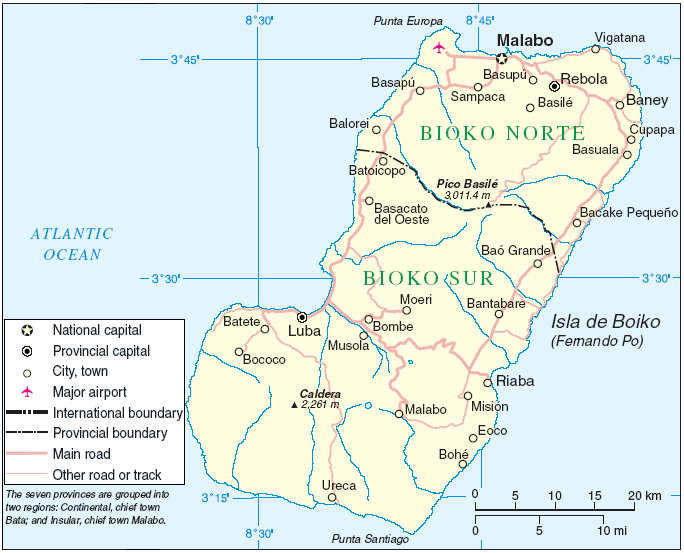
Bioko
Island · 1,994 km²
Bioko is an island in Africa, covering an estimated 1,994 km².
Bioko (; Spanish: [biˈoko] ; Bube: Ëtulá a Ëri; historically known as Fernando Pó, European Portuguese pronunciation: [fɨɾˈnɐ̃.dʊ ˈpɔ]) is an island of Equatorial Guinea. It is located 32 km (20 mi) south of the coast of Cameroon, and 160 km (99 mi) northwest of the northernmost part of mainland Equatorial Guinea. Malabo, on the north coast of the island, is the former capital city of Equatorial Guinea. Bioko's population was 335,048 at the 2015 census and it covers an area of 2,017 km2 (779 sq mi), making it the fourth largest island in Africa (after Madagascar, Socotra and Tenerife). The island is part of the Cameroon line of volcanoes and is located off the Cameroon coast, in the Bight of Biafra portion of the Gulf of Guinea. Its geology is volcanic; its highest peak is Pico Basile at 3,012 m (9,882 ft).
Adapted from Wikipedia: Bioko (CC BY-SA 4.0).
- Feature class
- Island
- Mapped extent
- 1,994 km²
- Size rank
- #250 of 445 islands
- Region
- Africa
- Coordinates
- 3.6142°, 8.7644°
- Summits:
- Pico de Santa Isabel (3,008 m), Mont Cameroun (4,040 m), Mount Oku (3,011 m)
- Ranges:
- Guinea Highlands (Africa), Marrah Mountains (Africa)
More about Bioko
Geography
Bioko lies in the Bight of Biafra on the Gulf of Guinea, about 32 kilometres (20 mi) off Cameroon and roughly 160 kilometres (99 mi) northwest of mainland Equatorial Guinea (Río Muni). The island's area is 2,017 square kilometres (779 sq mi); it is volcanic and mountainous, rising to Pico Basilé (3,011 metres (9,879 ft)).
Bioko has a total area of 2,017 km2 (779 sq mi). It is 70 km (43 mi) long from NNE to SSW and about 32 km (20 mi) across. The island is mostly covered by tropical rainforest. It is volcanic and very mountainous, with the highest peak, Pico Basilé, at an elevation of 3,012 m (9,882 ft). It thus resembles neighbouring islands São Tomé and Príncipe. Like them, it lies on the Cameroon line. Its southernmost point is called Punta Santiago.
History
Unlike other islands in the area, Bioko had an indigenous African population. The island was inhabited in the middle of the first millennium BC by Bantu tribes from the mainland, who formed the Bubi ethnic group. The Bubi speak a Bantu language. The island has probably been inhabited by this or other Bantu-speaking groups since before the 7th century BC.
In 1472, the Portuguese navigator Fernão do Pó was the first European to sight the island. He named it Formosa Flora ("beautiful flower"). In 1494, it was renamed Fernando Pó in his honour after the Portuguese claimed it as a colony. The Portuguese developed the island for sugarcane cultivation.
Climate
The island shows a strong north-south rainfall gradient driven by relief and the West African monsoon. Mean annual rainfall is ~1,930 millimetres (76 in) at Malabo (north) and ~10,920 millimetres (430 in) at Ureka in the south, among the highest recorded values in Africa. The principal wet season is April-October, with a drier season roughly November-March.
Protected areas and ecology
Two protected areas cover ~40% of the island: Pico Basilé National Park (est. 2000; ~32,256 ha) in the north, and the Luba Crater Scientific Reserve (~51,000 ha) in the south, a Key Biodiversity Area and AZE site centred on Mount Luba and the Gran Caldera.
Bioko forms part of the Cameroon line and hosts lowland Cross–Sanaga–Bioko coastal forests and Mount Cameroon and Bioko montane forests at elevation.
The endemic Pennant's red colobus Piliocolobus pennantii (CR) now persists primarily in southwest Bioko, and the drill Mandrillus leucophaeus (incl. the Bioko drill M. l. poensis) is globally Endangered.
Sections adapted from Wikipedia: Bioko (CC BY-SA 4.0).
Bioko: Key Facts
| Area | 1,935 km² |
|---|---|
| Population | 334,463 (2015) |
| Highest point | Pico Basilé |
| Surrounded by | Gulf of Guinea |
Facts from Wikidata Q205022 (CC0).
Mountain Ranges, Deserts and Landforms of Equatorial Guinea
1 landform recorded. Ranked by mapped area. Covers mountain ranges, deserts, plateaus, named glaciers, plains, basins, peninsulas and capes. One that crosses a border is listed under every country it lies in, with the area of the whole feature.
| # | Name | Area | Type | Region |
|---|---|---|---|---|
| 1 | Africa | 29.41M km² | Continent | Africa |
Countries Bordering Equatorial Guinea
Land and maritime neighbours.
More Maps in Africa
Equatorial Guinea: Quick Answers
- What is the capital of Equatorial Guinea?
- The capital of Equatorial Guinea is Ciudad de la Paz.
- What is the population of Equatorial Guinea?
- Equatorial Guinea has a population of about 1.94 million, the #150 largest of 225 countries in YearMaps. Source: World Bank, 2025.
- How big is Equatorial Guinea?
- Equatorial Guinea covers 28,051 km², ranking #147 by area, with about 69 people per square kilometre.
- Which continent is Equatorial Guinea in?
- Equatorial Guinea is in Africa.
- Which countries border Equatorial Guinea?
- Equatorial Guinea shares a land or maritime border with Gabon, Cameroon, Sao Tome and Principe.
- What is the largest city in Equatorial Guinea?
- Bata is the largest city in Equatorial Guinea, with a metropolitan population of about 173,046.
- What is the highest mountain in Equatorial Guinea?
- The highest summit recorded for Equatorial Guinea in YearMaps is Pico de Santa Isabel at 3,008 m (9,869 ft). Summits on a border are counted for both countries.