Skip to content
YearMaps
France · Landforms

Mountain Ranges, Deserts and Landforms of France

South America is the largest of the 14 mountain ranges, deserts and other landforms recorded for France, at 17.91M km², ahead of Europe at 11.24M km². The full list follows.

How this list is built: Ranked by mapped area. Covers mountain ranges, deserts, plateaus, named glaciers, plains, basins, peninsulas and capes. One that crosses a border is listed under every country it lies in, with the area of the whole feature. It covers the mountain ranges, deserts and other landforms indexed in YearMaps, drawn from open geospatial data, and is not an exhaustive national register.

Landforms Listed
14
Top Ranked
17.91M km²
South America
Second
11.24M km²
Europe
Profiled Below
10
Photo, encyclopedia text and figures
Mountain Ranges, Deserts and Landforms of France
#NameArea
1South America17.91M km²
2Europe11.24M km²
3Northern European Plain774,604 km²
4Guiana Shield348,461 km²
5Alps176,042 km²
6Massif Central55,181 km²
7Pyrenees20,678 km²
8Tumuc-Humac Mountains16,058 km²
9Vosges12,547 km²
10Ardennes11,497 km²
11Riviera11,427 km²
12Jura10,852 km²
13Normandie1,308 km²
14Bretagne263 km²

The Landforms of France in Detail

The 10 mountain ranges, deserts and other landforms above that have an encyclopedia article, in the same order, each with its photograph, figures and the places around it.

South America
Image via Wikimedia Commons (author and licence on the file page).

South America

Continent · 17.91M km²

South America is a continent in South America, covering an estimated 17.91M km². It extends across Brazil, Argentina, Chile, Guyana, Venezuela, Ecuador, Suriname, Colombia, Bolivia, Paraguay, Uruguay, France and Peru. It is the 4th-largest of the 231 landforms with a mapped extent in YearMaps.

South America is a continent entirely in the Western Hemisphere and most in the Southern Hemisphere, with a considerably smaller portion in the Northern Hemisphere. It can also be described as the southern subregion of the Americas.

South America is bordered on the west by the Pacific Ocean, on the north and east by the Atlantic Ocean, and on the south by the Drake Passage; North America, the Caribbean Sea lying to the northwest, and the Antarctic Circle, Antarctica, and the Antarctic Peninsula to the south.

The continent includes twelve sovereign countries: Argentina, Bolivia, Brazil, Chile, Colombia, Ecuador, Guyana, Paraguay, Peru, Suriname, Uruguay, and Venezuela; two dependent territories: the Falkland Islands and South Georgia and the South Sandwich Islands; and one internal territory: French Guiana.

The Caribbean South America ABC islands (Aruba, Bonaire, and Curaçao) and Trinidad and Tobago are geologically located on the South-American continental shelf, and thus may be considered part of South America as well.

Adapted from Wikipedia: South America (CC BY-SA 4.0).

Feature class
Continent
Mapped extent
17.91M km²
Size rank
#4 of 231 landforms
Region
South America
Countries
Brazil, Argentina, Chile, Guyana, Venezuela, Ecuador, Suriname, Colombia, Bolivia, Paraguay, Uruguay, France, Peru
Coordinates
-4.1242°, -64.8745°
Summits:
Montagne Pelée (1,397 m), Puy de Sancy (1,885 m), Crêt de la Neige (1,718 m)
Ranges:
Tumuc-Humac Mountains (South America), Wilhelmina Gebergte (South America)
Settlements:
Biarritz (6,701 km), Brest (6,757 km), Lorient (6,795 km)

View on the live map

More about South America

Geography

South America occupies the southern portion of the Americas. The continent is generally delimited on the northwest by the Darién watershed along the Colombia–Panama border, although some may consider the border instead to be the Panama Canal. Geopolitically and geographically, all of Panama – including the segment east of the Panama Canal in the isthmus – is typically included in North America alone and among the countries of Central America. Almost all of mainland South America sits on the South American Plate.

History

South America is thought to have been first inhabited by humans when people were crossing the Bering Land Bridge (now the Bering Strait) at least 15,000 years ago from the territory that is present-day Russia. They migrated south through North America, and eventually reached South America through the Isthmus of Panama.

Amongst the oldest evidence for human presence in South America is the Monte Verde II site in Chile, suggested to date to around 14,500 years ago. From around 13,000 years ago, the Fishtail projectile point style became widespread across South America, with its disappearance around 11,000 years ago coincident with the disappearance of South America's megafauna.

Economy

Since 1930, the continent has experienced growth and diversification in most economic sectors. Most agricultural and livestock products are destined for the domestic market and local consumption. However, the export of agricultural products is essential for the balance of trade in most countries.

The main agrarian crops are export crops, such as soy and wheat. The production of staple foods such as vegetables, corn or beans is large, but focused on domestic consumption. Livestock raising for meat exports is significant in Argentina, Paraguay, Uruguay and Colombia. In tropical regions the most important crops are coffee, cocoa and bananas, mainly in Brazil, Colombia and Ecuador.

Sections adapted from Wikipedia: South America (CC BY-SA 4.0).

South America: Key Facts

Key facts about South America
Area17,461,112 km²
Highest pointAconcagua
OnAtlantic Ocean, Pacific Ocean

Facts from Wikidata Q18 (CC0).

Guiana Shield
Image via Wikimedia Commons (author and licence on the file page).

Guiana Shield

Plateau · 348,461 km²

Guiana Shield is a plateau in South America, covering an estimated 348,461 km². It extends across Venezuela, Guyana, Brazil, France, Suriname and Colombia. It is the 11th-largest of the 69 plateaus with a mapped extent in YearMaps.

The Guiana Shield (French: Plateau des Guyanes, Bouclier guyanais; Dutch: Hoogland van Guyana, Guianaschild; Portuguese: Planalto das Guianas, Escudo das Guianas; Spanish: Escudo guayanés) is one of the three cratons of the South American plate. It is a 1.7 billion-year-old Precambrian geological formation in northeast South America that forms a portion of the northern coast. The higher elevations on the shield are called the Guiana Highlands, which is where the table-like mountains called tepuis are found. The Guiana Highlands are also the source of some of the world's most well-known waterfalls such as Angel Falls, Kaieteur Falls, and Cuquenan Falls.

The Guiana Shield underlies Guyana (previously British Guiana), Suriname (previously Dutch Guiana), and French Guiana (or Guyane), much of southern Venezuela, most of Brazil north of the Amazon River, and parts of eastern Colombia. The first three are called The Guianas, and most of the Guiana Shield coincides with Guiana Island.

Adapted from Wikipedia: Guiana Shield (CC BY-SA 4.0).

Feature class
Plateau
Mapped extent
348,461 km²
Size rank
#11 of 69 plateaus
Region
South America
Countries
Venezuela, Guyana, Brazil, France, Suriname, Colombia
Coordinates
5.8962°, -65.5319°
Summits:
Montagne Pelée (1,397 m), Puy de Sancy (1,885 m), Crêt de la Neige (1,718 m)
Ranges:
Tumuc-Humac Mountains (South America), Wilhelmina Gebergte (South America)
Settlements:
Biarritz (6,579 km), Brest (6,626 km), Lorient (6,665 km)

View on the live map

More about Guiana Shield

Geology

The oldest rocks in the shield consist of Archean Imataca Complex, composed of a quartz-feldspar gneiss and subordinate mafic gneiss. The Guri Fault marks the southern boundary of the complex. South of that fault are Early Proterozoic rocks consisting of the metavolcanic Pastora Supergroup and the granitic plutonic Supamo Complex. The Cuchivero Group consists of ash flow tuff and granitic plutonic rocks. The Early to Middle Proterozoic Roraima Group consists of continental clastic sedimentary rocks. These Precambrian sediments include quartz sandstones, quartzites, and conglomerates presumed to be 1.8 to 1.4 Ga in age.

Ecology

The Guiana Shield is one of the world's most biodiverse regions, and has many endemic species. The region houses over 3000 vertebrate species: 1168 fresh water fish, 269 amphibians (54% endemics), 295 reptiles (29%), 1004 birds (7.7%), and 282 mammals (11%). Diversity of invertebrates remains largely undocumented, but there are several species of endemic butterflies and dung beetles.

Plant life is equally rich and 13,367 species of vascular plants have been found, approximately 40% of which is considered endemic. The shield is overlain by the largest expanse of tropical forest on any Precambrian shield area in the world.

Sections adapted from Wikipedia: Guiana Shield (CC BY-SA 4.0).

Guiana Shield: Key Facts

Key facts about Guiana Shield
Highest pointPico da Neblina

Facts from Wikidata Q9309106 (CC0).

Alps
Image via Wikimedia Commons (author and licence on the file page).

Alps

Range/mtn · 176,042 km²

Alps is a range/mtn in Europe, covering an estimated 176,042 km². It extends across Austria, Italy, France, Switzerland, Germany, Slovenia, Liechtenstein, Monaco and Hungary. It is the 24th-largest of the 216 mountain ranges with a mapped extent in YearMaps.

The Alps () are some of the highest and most extensive mountain ranges in Europe, stretching approximately 1,200 km (750 mi) across several Alpine countries (from west to east): Monaco, France, Switzerland, Italy, Liechtenstein, Germany, Austria, and Slovenia.

The Alpine arch extends from Nice on the western Mediterranean to Trieste on the Adriatic and Vienna at the beginning of the Pannonian Basin. The mountains were formed over tens of millions of years as the African and Eurasian tectonic plates collided. Extreme shortening caused by the event resulted in marine sedimentary rocks rising by thrusting and folding into high mountain peaks such as Mont Blanc and the Matterhorn. The Alpine region area contains 82 peaks higher than 4,000 m (13,000 ft). The altitude and size of the range affect the climate in Europe, and in the mountains, precipitation levels vary greatly and climatic conditions consist of distinct zones.

Evidence of human habitation in the Alps goes back to the Palaeolithic era. A mummified man ("Ötzi"), determined to be 5,000 years old, was discovered on a glacier at the Austrian–Italian border in 1991.

Adapted from Wikipedia: Alps (CC BY-SA 4.0).

Feature class
Range/mtn
Mapped extent
176,042 km²
Size rank
#24 of 216 mountain ranges
Region
Europe
Countries
Austria, Italy, France, Switzerland, Germany, Slovenia, Liechtenstein, Monaco, Hungary
Coordinates
46.7662°, 10.7276°
Summits:
Mount Blanc (4,807 m), Mont Agel (140 m), Crêt de la Neige (1,718 m)
Adjacent ranges:
Jura (Europe), Pyrenees (Europe)
Settlements:
Grenoble (54 km), Annecy (117 km), Lyon (150 km)

View on the live map

More about Alps

Geography

The Alps are a crescent shaped geographic feature of central Europe that ranges in an 800 km (500 mi) arc (curved line) from east to west and is 200 km (120 mi) in width. The mean height of the mountain peaks is 2.5 km (1.6 mi). The range stretches from the Mediterranean Sea north above the Po basin, extending through France from Grenoble, and stretching eastward through mid and southern Switzerland. The range continues onward toward Vienna, Austria, and southeast to the Adriatic Sea and Slovenia. Depending on the definitions used, the Alpokalja foothills in western Hungary may also qualify as part of the Alps.

To the south it dips into northern Italy and to the north extends to the southern border of Bavaria in Germany.

Geology

Important geological concepts were established as naturalists began studying the rock formations of the Alps in the 18th century. In the mid-19th century, the now-defunct idea of geosynclines was used to explain the presence of "folded" mountain chains. This theory was replaced in the mid-20th century by the theory of plate tectonics.

The formation of the Alps (the Alpine orogeny) was an episodic process that began about 300 million years ago. In the Paleozoic Era the Pangaean supercontinent consisted of a single tectonic plate; it broke into separate plates during the Mesozoic Era and the Tethys sea developed between Laurasia and Gondwana during the Jurassic Period.

Ecology

Thirteen thousand species of plants have been identified in the Alpine regions. Alpine plants are grouped by habitat and soil type which can be limestone or non-calcareous. The habitats range from meadows, bogs, and woodland (deciduous and coniferous) areas to soil-less scree and moraines, and rock faces and ridges. A natural vegetation limit with altitude is given by the presence of the chief deciduous trees—oak, beech, ash and sycamore maple. These do not reach the same elevation, nor are they often found growing together, but their upper limit corresponds accurately enough to the change from a temperate to a colder climate that is further proved by a change in the presence of wild herbaceous vegetation.

History

When the ice melted after the Würm glaciation, Paleolithic settlements were established along the lake shores and in cave systems. Evidence of human habitation has been found in caves near the Vercors Cave System, close to Grenoble and Echirolles. In Austria, the Mondsee lake shows evidence of houses built on piles. Standing stones have been found in the Alpine areas of France and Italy. About 200,000 drawings and etchings have been documented, and are known as the Rock Drawings in Valcamonica.

A mummy of a Neolithic human, known as Ötzi, was discovered on the Similaun.

Sections adapted from Wikipedia: Alps (CC BY-SA 4.0).

Alps: Key Facts

Key facts about Alps
Length1,200 km
Area190,000 km²
Highest pointMont Blanc

Facts from Wikidata Q1286 (CC0).

Massif Central
Image via Wikimedia Commons (author and licence on the file page).

Massif Central

Plateau · 55,181 km²

Massif Central is a plateau in Europe, covering an estimated 55,181 km².

The Massif Central (French pronunciation: [masif sɑ̃tʁal]) is a highland region in south-central France consisting of mountains and plateaus. It covers about 15% of mainland France.

Subject to volcanism that has subsided in the last 10,000 years, these central mountains are separated from the Alps by a deep north–south cleft created by the Rhône river and known in French as the sillon rhodanien (literally "Rhône furrow"). The region was a barrier to transport within France until the opening of the A75 motorway, which not only made north–south travel easier but also opened access to the massif itself.

Adapted from Wikipedia: Massif Central (CC BY-SA 4.0).

Feature class
Plateau
Mapped extent
55,181 km²
Size rank
#48 of 69 plateaus
Region
Europe
Coordinates
44.8236°, 3.2856°
Summits:
Puy de Sancy (1,885 m), Crêt de la Neige (1,718 m), Pic de Coma Pedrosa (2,943 m)
Ranges:
Pyrenees (Europe), Jura (Europe)
Settlements:
Clermont-Ferrand (108 km), Saint-Étienne (109 km), Nîmes (139 km)

View on the live map

More about Massif Central

Geography and geology

The Massif Central is an old massif, formed during the Variscan orogeny, consisting mostly of granitic and metamorphic rocks. It was powerfully raised and made to look geologically younger in the eastern section by the uplift of the Alps during the Paleogene period and in the southern section by the uplift of the Pyrenees. The massif thus presents a strongly asymmetrical elevation profile with highlands in the south and in the east (Cévennes) dominating the valley of the Rhône and the plains of Languedoc and, by contrast, the less elevated region of Limousin in the northwest.

These tectonic movements created faults and may be at the origin of the volcanism in the massif (but the hypothesis is not yet proven).

Economy

In the Massif Central, the industry remains little developed except locally (metallurgy in Saint-Étienne; tyres in Clermont-Ferrand, headquarters of Michelin, world leader in the sector; aeronautics industry in Figeac, etc.). The other industries present are linked to agriculture (Groupe Limagrain, the world's third-largest seed producer and cheese-producing industries that export to the world such as Cantal and Roquefort).

On the agricultural level, the Limagne plain is dominated by major cereal crops, but in the mountains, it is mainly livestock farming that predominates: cattle farming in the west for meat and milk (Cantal cheese), sheep farming in the south on the limestone plateaus (Roquefort cheese).

Sections adapted from Wikipedia: Massif Central (CC BY-SA 4.0).

Massif Central: Key Facts

Key facts about Massif Central
Area85,000 km²
Elevation1,886 m
Highest pointPuy de Sancy

Facts from Wikidata Q190695 (CC0).

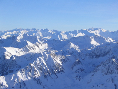
Pyrenees
Image via Wikimedia Commons (author and licence on the file page).

Pyrenees

Range/mtn · 20,678 km²

Pyrenees is a range/mtn in Europe, covering an estimated 20,678 km². It extends across France, Spain and Andorra.

The Pyrenees is a mountain range in southwestern Europe, straddling the France–Spain border. The Pyrenees extend nearly 500 kilometres (310 mi) from their union with the Cantabrian Mountains to Cap de Creus on the Mediterranean coast, reaching a maximum elevation of 3,404 metres (11,168 ft) at the peak of Aneto, in Huesca, Spain.

The main crest mostly forms a political divide between the states of Spain and France, with the microstate of Andorra sandwiched in between. Historically, the Crown of Aragon and the Kingdom of Navarre extended on both sides of the mountain range.

Adapted from Wikipedia: Pyrenees (CC BY-SA 4.0).

Feature class
Range/mtn
Mapped extent
20,678 km²
Size rank
#124 of 216 mountain ranges
Region
Europe
Countries
France, Spain, Andorra
Coordinates
42.5744°, 2.5416°
Summits:
Puy de Sancy (1,885 m), Mont Agel (140 m), Crêt de la Neige (1,718 m)
Adjacent ranges:
Jura (Europe), Vosges (Europe)
Settlements:
Tarbes (71 km), Toulouse (91 km), Agen (143 km)

View on the live map

More about Pyrenees

Geography

The Spanish Pyrenees are part of the following provinces, from east to west: Girona, Barcelona and Lleida (all in Catalonia), Huesca and Zaragoza (both in Aragon), Navarra (in Navarre) and Gipuzkoa (in the Basque Country).

The French Pyrenees are part of the following départements, from east to west: Pyrénées-Orientales (also known as Northern Catalonia), Aude, Ariège, Haute-Garonne, Hautes-Pyrénées, and Pyrénées-Atlantiques (the latter two of which include the Pyrenees National Park).

The independent principality of Andorra is sandwiched in the eastern portion of the mountain range between the Spanish Pyrenees and French Pyrenees.

Physiographically, the Pyrenees may be divided into three sections: the Atlantic (or Western), the Central, and the Eastern Pyrenees.

Geology

The Pyrenees are older than the Alps: their sediments were first deposited in coastal basins during the Paleozoic and Mesozoic eras. During Ediacaran to Ordovician times, Pyrenees were located at the Northwest margin of Gondwana, where they formed a lateral continuity of neighbouring areas, such as the Montagne Noire and the Mouthoumet massifs and Southwestern territory of Sardinia. Between 100 and 150 million years ago, during the Early Cretaceous Period, the Bay of Biscay fanned out, pushing present-day Spain against France and applying intense compressional pressure to large layers of sedimentary rock. The intense pressure and uplifting of the Earth's crust first affected the eastern part and moved progressively to the entire chain, culminating in the Eocene Epoch.

Climate

The amount of precipitation the range receives, including rain and snow, is much greater in the western than in the eastern Pyrenees because of the moist air that blows in from the Atlantic Ocean over the Bay of Biscay. After dropping its moisture over the western and central Pyrenees, the air is left dry over the eastern Pyrenees. The winter average temperature is −2 °C (28 °F).

Sections of the mountain range vary in more than one respect. There are some glaciers in the western and snowy central Pyrenees, but there are no glaciers in the eastern Pyrenees because there is insufficient snowfall to cause their development.

Sections adapted from Wikipedia: Pyrenees (CC BY-SA 4.0).

Pyrenees: Key Facts

Key facts about Pyrenees
Length491 km
Area19,000 km²
Highest pointAneto

Facts from Wikidata Q12431 (CC0).

Tumuc-Humac Mountains
Image via Wikimedia Commons (author and licence on the file page).

Tumuc-Humac Mountains

Range/mtn · 16,058 km²

Tumuc-Humac Mountains is a range/mtn in South America, covering an estimated 16,058 km². It extends across Suriname, France and Brazil.

The Tumuk Humak Mountains (Dutch: Toemoek-Hoemakgebergte, Portuguese: Serra do Tumucumaque, French: Monts Tumuc Humac) are a mountain range in South America, stretching about 120 kilometers (75 mi) east–west in the border area between Brazil in the south and Suriname and French Guiana in the north. In the language of the Apalam and Wayana peoples, Tumucumaque means "the mountain rock symbolizing the struggle between the shaman and the spirits". The range is very remote and almost inaccessible.

Both the Maroni and Oyapock rivers rise in the Tumuk Humak Mountains. The Maroni (Dutch: Marowijne) forms the entire (disputed) border between Suriname and French Guiana, and the Oyapock (Portuguese: Oiapoque) most of the border between French Guiana and Brazil.

The Tumuk Humak Mountains are part of the Tumucumaque Uplands of the Guiana Shield. They are geographically important because they form the divide between the biogeographical system of the Amazon Basin and that of the Atlantic coastal area of the Guianas. The Tumuk Humak plateau is covered primarily with lowland and plateau forests.

Adapted from Wikipedia: Tumuk Humak Mountains (CC BY-SA 4.0).

Feature class
Range/mtn
Mapped extent
16,058 km²
Size rank
#135 of 216 mountain ranges
Region
South America
Countries
Suriname, France, Brazil
Coordinates
2.3696°, -54.3244°
Summits:
Montagne Pelée (1,397 m), Puy de Sancy (1,885 m), Crêt de la Neige (1,718 m)
Adjacent ranges:
Wilhelmina Gebergte (South America), Serra da Ibiapaba (South America)
Settlements:
Biarritz (6,855 km), Brest (6,921 km), Lorient (6,957 km)

View on the live map

More about Tumuc-Humac Mountains

Tumuc-Humac Mountains: Key Facts

Key facts about Tumuc-Humac Mountains
Highest pointBellevue de l'Inini

Facts from Wikidata Q1457996 (CC0).

Vosges
Image via Wikimedia Commons (author and licence on the file page).

Vosges

Range/mtn · 12,547 km²

Vosges is a range/mtn in Europe, covering an estimated 12,547 km². It extends across France and Germany.

The Vosges ( VOHZH, French: [voʒ] ; German: Vogesen [voˈɡeːzn̩] ; Franconian and Alemannic German: Vogese) are a range of medium mountains in Eastern France, near its border with Germany. Together with the Palatine Forest to the north on the German side of the border, they form a single geomorphological unit and low mountain range of around 8,000 km2 (3,100 sq mi) in area. It runs in a north-northeast direction from the Burgundian Gate (the Belfort–Ronchamp–Lure line) to the Börrstadt Basin (the Winnweiler–Börrstadt–Göllheim line), and forms the western boundary of the Upper Rhine Plain.

The Grand Ballon is the highest peak at 1,424 m (4,672 ft), followed by the Storkenkopf (1,366 m, 4,482 ft), and the Hohneck (1,364 m, 4,475 ft).

Adapted from Wikipedia: Vosges (CC BY-SA 4.0).

Feature class
Range/mtn
Mapped extent
12,547 km²
Size rank
#145 of 216 mountain ranges
Region
Europe
Countries
France, Germany
Coordinates
48.4023°, 7.0143°
Summits:
Crêt de la Neige (1,718 m), Mount Blanc (4,807 m), Puy de Sancy (1,885 m)
Adjacent ranges:
Jura (Europe), Ardennes (Europe)
Settlements:
Strasbourg (51 km), Nancy (68 km), Mulhouse (85 km)

View on the live map

More about Vosges

Geography

The Higher Vosges or High Vosges (Hautes Vosges), extending in the southern part of the range from Belfort to the river valley of the Bruche. The rounded summits of the Hautes Vosges are called ballons in French, literally "balloons".

The Lower Vosges or Low Vosges (48 km, 30 mi), commonly known as North Vosges, a sandstone plateau ranging from 300 metres (1,000 ft) to 560 metres (1,850 ft) high, between the Col de Saverne and the source of the Lauter.

In addition, the term "Central Vosges" is used to designate the various lines of summits, especially those above 1,000 m (3,300 ft) in elevation. The French department of Vosges is named after the range.

Climate

Meteorologically, as a consequence of the Foehn effect the difference between the eastern and western mean slopes of the range is very marked. The main air streams come generally from the west and southwest, so the Alsatian central plains just under the Hautes-Vosges receive much less precipitation than the southwest slope of the Vosges Mountains. The highlands of the canton of Remiremont receive as annual rainfall or snowfall more than 2,000 mm (79 in) of precipitation yearly, whereas some dry countryside near Colmar receives less than 500 mm (20 in) of precipitation in the event of insufficient storms. The temperature is much lower in the west front of the mountains than in the low plains behind the massif, especially in summer.

History

The massif known in Latin as Vosago mons or Vosego silva, sometimes Vogesus mons, was extended to the vast woods covering the region. Later, German speakers referred to the same region as Vogesen or Wasgenwald.

Over the centuries, settlement population density grew gradually, as was typical for a forested region. Forests were cleared for agriculture, livestock and early industrial factories (such as charcoal works and glassworks) and the water mills used water power. Concentrations of settlement and immigration took place and not only in areas where minerals were found. In the mining area of the Lièpvrette valley, for example, there was an influx of Saxon miners and mining specialists.

Sections adapted from Wikipedia: Vosges (CC BY-SA 4.0).

Vosges: Key Facts

Key facts about Vosges
Length120 km
Area5,500 km²
Highest pointGrand Ballon

Facts from Wikidata Q187843 (CC0).

Ardennes
Image via Wikimedia Commons (author and licence on the file page).

Ardennes

Range/mtn · 11,497 km²

Ardennes is a range/mtn in Europe, covering an estimated 11,497 km². It extends across Belgium, France and Luxembourg.

The Ardennes, also known as the Ardennes Forest or Forest of Ardennes, is a region of extensive forests, rough terrain, rolling hills and ridges primarily in Belgium and Luxembourg, extending into Germany and France.

Geologically, the range is a western extension of the Eifel; both were raised during the Givetian age of the Devonian (382.7 to 387.7 million years ago), as were several other named ranges of the same greater range.

The Ardennes proper stretches well into Germany and France (lending its name to the Ardennes department and the former Champagne-Ardenne region) and geologically into the Eifel (the eastern extension of the Ardennes Forest into Bitburg-Prüm, Germany); most of it is in the southeast of Wallonia, the southern and more rural part of Belgium (away from the coastal plain but encompassing more than half of the country's total area). The eastern part of the Ardennes forms the northernmost third of the Grand Duchy of Luxembourg, also called "Éislek" (German: Oesling). On the southeast the Eifel region continues into the German state of the Rhineland-Palatinate.

Adapted from Wikipedia: Ardennes (CC BY-SA 4.0).

Feature class
Range/mtn
Mapped extent
11,497 km²
Size rank
#147 of 216 mountain ranges
Region
Europe
Countries
Belgium, France, Luxembourg
Coordinates
49.9430°, 4.9037°
Summits:
Crêt de la Neige (1,718 m), Mount Blanc (4,807 m), Puy de Sancy (1,885 m)
Adjacent ranges:
Vosges (Europe), Jura (Europe)
Settlements:
Reims (70 km), Metz (128 km), Arras (148 km)

View on the live map

More about Ardennes

Geography

Much of the Ardennes is covered in dense forests, with the hills averaging around 350–400 m (1,150–1,310 ft) in height but rising to over 694 m (2,277 ft) in the boggy moors of the High Fens region of south-eastern Belgium. The region is typified by steep-sided valleys carved by swift-flowing rivers, the most prominent of which is the Meuse. Its most populous cities are Verviers in Belgium and Charleville-Mézières in France, both exceeding 50,000 inhabitants. The Ardennes is otherwise relatively sparsely populated, with few of the towns exceeding 10,000 inhabitants. (Exceptions include Belgium's Eupen and Bastogne.)

The Eifel range in Germany adjoins the Ardennes and is part of the same geological formation, although they are conventionally regarded as being two distinct areas.

Geology

The Ardennes are the remnants of a mountain range formed during the Hercynian orogeny; in France similar formations are the Armorican Massif, the Massif Central, and the Vosges. The low interior of such former mountains often contains coal, plus iron, zinc and other metals in the sub-soil. This geologic fact explains the greatest part of the geography of Wallonia and its history. In the North and West of the Ardennes lie the valleys of the Sambre and Meuse rivers, forming an arc (Sillon industriel) going across the most industrial provinces of Wallonia, for example Hainaut Province, along the river Haine (the etymology of Hainaut); the Borinage, the Centre and Charleroi along the river Sambre; Liège Province along the river Meuse.

History

The modern Ardennes region covers a greatly diminished area from the forest recorded in Roman times.

A song about Charlemagne, the Old French 12th-century chanson de geste Quatre Fils Aymon, mentions many of Wallonia's rivers, villages and other places. In Dinant the rock named Bayard takes its name from Bayard, the magic bay horse which, according to legend, jumped from the top of the rock to the other bank of the Meuse.

On their pillaging raids in the years 881 and 882, the Vikings used the old Roman roads in the Ardennes, attacking the abbeys of Malmedy and Stavelot and destroying Prüm Abbey in the Eifel.

The strategic position of the Ardennes has made it a battleground for European powers for many centuries.

Economy

The Ardennes includes the greatest part of Belgium's Luxembourg Province (not to be confused with the neighbouring Grand Duchy of Luxembourg), the south of Namur Province, and Liège Province, plus a very small part of Hainaut Province, as well as the northernmost third of the Grand Duchy of Luxembourg, called "Éislek" (German: Ösling) and the main part of the French Ardennes department.

Sections adapted from Wikipedia: Ardennes (CC BY-SA 4.0).

Ardennes: Key Facts

Key facts about Ardennes
Length160 km
Highest pointSignal de Botrange
Part ofRhenish Massif

Facts from Wikidata Q151985 (CC0).

Riviera
Image via Wikimedia Commons (author and licence on the file page).

Riviera

Coast · 11,427 km²

Riviera is a coast in Europe, covering an estimated 11,427 km². It extends across Italy and France.

Riviera (pronounced [riˈvjɛːra]) is an Italian word which means 'coastline', ultimately derived from Latin rīpa, through Ligurian rivêa. It came to be applied as a proper name to the coast of Liguria (the Genoa region in northwestern Italy) in the form Riviera ligure, then shortened in English.

Adapted from Wikipedia: Riviera (CC BY-SA 4.0).

Feature class
Coast
Mapped extent
11,427 km²
Size rank
#117 of 231 landforms
Region
Europe
Countries
Italy, France
Coordinates
43.4021°, 6.3650°
Summits:
Mont Agel (140 m), Mount Blanc (4,807 m), Crêt de la Neige (1,718 m)
Ranges:
Pyrenees (Europe), Jura (Europe)
Settlements:
Nice (52 km), Toulon (75 km), Aix-en-Provence (98 km)

View on the live map

Jura
Image via Wikimedia Commons (author and licence on the file page).

Jura

Range/mtn · 10,852 km²

Jura is a range/mtn in Europe, covering an estimated 10,852 km². It extends across France and Switzerland.

The Jura Mountains (Jura Massif, JOOR-ə, ZHOOR-ə) are a sub-alpine mountain range, a short distance north of the Western Alps, and mainly demarcate a long part of the French–Swiss border. While the Jura range proper ("folded Jura", Faltenjura) is located in France and Switzerland, the range continues northeastwards through northern Switzerland and Germany as the Table Jura ("not folded Jura", Tafeljura), which is crossed by the High Rhine.

Adapted from Wikipedia: Jura Mountains (CC BY-SA 4.0).

Feature class
Range/mtn
Mapped extent
10,852 km²
Size rank
#148 of 216 mountain ranges
Region
Europe
Countries
France, Switzerland
Coordinates
47.2512°, 6.8680°
Summits:
Crêt de la Neige (1,718 m), Mount Blanc (4,807 m), Puy de Sancy (1,885 m)
Adjacent ranges:
Vosges (Europe), Alps (Europe)
Settlements:
Besançon (40 km), Dijon (109 km), Mulhouse (116 km)

View on the live map

More about Jura

Ecology

Some alpine butterfly populations have reduced markedly recently. Butterflies have been shown to be more vulnerable to climate change than birds. A study of three such alpine butterfly species over a period of the last glacial cycle suggests habitat loss and its deterioration are major drivers of this decline in population.

Tourism

The Jura range offer a variety of tourist activities including hiking, cycling, downhill skiing and cross-country skiing. There are many signposted trails including the Jura ridgeway, a 310 km (190 mi) hiking route. Several peaks feature observation towers (e.g. Faux d'Enson, Hage).

Tourist attractions in the Swiss Jura include natural features such as the Creux du Van, lookout peaks such as the Chasseral, caves such as the Grottes de Vallorbe, as well as gorges such as Taubenloch. The Swiss Jura has been industrialized since the 18th century and became a major centre of the watchmaking industry.

Sections adapted from Wikipedia: Jura Mountains (CC BY-SA 4.0).

Jura: Key Facts

Key facts about Jura
Length340 km
Area14,000 km²
Highest pointCrêt de la Neige

Facts from Wikidata Q178611 (CC0).

More on France

Quick Answers

What is the largest landform in France?
South America, at 17.91M km². Europe is second at 11.24M km². Rankings cover the mountain ranges, deserts and other landforms indexed in YearMaps.
How many mountain ranges, deserts and other landforms are there in France?
YearMaps lists 14 mountain ranges, deserts and other landforms for France. This is the number mapped in the atlas, not an official national count.