Skip to content
YearMaps
Fiji · Islands

Largest Islands of Fiji

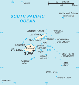
Viti Levu is the largest of the 6 islands recorded for Fiji, at 10,929 km², ahead of Vanua Levu at 5,751 km². The full list follows.

How this list is built: Ranked by mapped area. An island divided between countries is listed under each, with the area of the whole island. It covers the islands indexed in YearMaps, drawn from open geospatial data, and is not an exhaustive national register.

Islands Listed
6
Top Ranked
10,929 km²
Viti Levu
Second
5,751 km²
Vanua Levu
Profiled Below
6
Photo, encyclopedia text and figures
Largest Islands of Fiji
#NameArea
1Viti Levu10,929 km²
2Vanua Levu5,751 km²
3Fiji1,134 km²
4Kadavu491 km²
5Lau Group24 km²
6Taveuni3 km²

The Islands of Fiji in Detail

The 6 islands above that have an encyclopedia article, in the same order, each with its photograph, figures and the places around it.

Viti Levu
Image via Wikimedia Commons (author and licence on the file page).

Viti Levu

Island group · 10,929 km²

Viti Levu is an island group in Oceania (Melanesia), covering an estimated 10,929 km².

Viti Levu (Fijian: [ˈβitʃi ˈleβu]; lit. 'Great Fiji') is the largest island in Fiji. It is the site of the country's capital and largest city, Suva, and home to a large majority of Fiji's population.

Adapted from Wikipedia: Viti Levu (CC BY-SA 4.0).

Feature class
Island group
Mapped extent
10,929 km²
Size rank
#148 of 445 islands
Region
Oceania
Subregion
Melanesia
Coordinates
-17.8264°, 177.9813°
Summits:
Tomanivi (1,323 m), Mauga Silisili (1,858 m), Mount Tabwemasana (1,877 m)
Ranges:
Southern Alps (Oceania), Owen Stanley Range (Oceania)
Settlements:
Suva (59 km), Lautoka (59 km), Nandi (60 km)

View on the live map

More about Viti Levu

Geography, economy and ecology

Viti Levu is the largest island in the Republic of Fiji – home to 70% of the population (about 600,000 people) – and is the hub of the entire Fijian archipelago. It measures 146 kilometres (91 mi) long and 106 kilometres (66 mi) wide, and has an area of 10,389 square kilometres (4,011 sq mi). Earthquakes and volcanic eruptions account for the somewhat rugged terrain of the island, which is divided into roughly equal halves by a mountain range that runs north to south. The centre of the island is forested and includes the nation's highest peak Mount Tomanivi (otherwise known as Mount Victoria), which rises to 1,324 metres (4,344 ft).

The eastern side of the island experiences heavy rainfall, particularly in the mountains, and is home to Fiji's tropical moist forests.

History

Viti Levu is believed to have been inhabited longer than the island of Vanua Levu, which lies to its north. According to oral tradition, the first Melanesian settlers landed at Vuda Point and established Viseisei as Fiji's first oldest settlement. There is archaeological evidence contradicting this account.

Geology

Fiji lies in a tectonically complex area between the Australian plate and the Pacific plate. The Fiji Platform lies in a zone bordered by active extension fault lines, around which most of the shallow earthquakes in the area have been centred. These fault lines are: the Fiji Fracture Zone (FFZ) to the north; the 176° Extension Zone (176°E EZ) to the west; and the Hunter fracture zone (HFZ) and Lau Ridge to the east.

is made up of volcanic flows and volcaniclastics, which grade from basalt to trachyte and rhyolite. Geographically, this group is found south of Nadi, including on the peaks of Koromba (at 3528 feet high) and Natambumgguto (at 1242 feet high), and down to Sigatoka.

Sections adapted from Wikipedia: Viti Levu (CC BY-SA 4.0).

Viti Levu: Key Facts

Key facts about Viti Levu
Area10,531 km²
Population580,000
Highest pointMount Tomanivi
Surrounded byPacific Ocean

Facts from Wikidata Q208198 (CC0).

Vanua Levu
Image via Wikimedia Commons (author and licence on the file page).

Vanua Levu

Island group · 5,751 km²

Vanua Levu is an island group in Oceania (Melanesia), covering an estimated 5,751 km².

Vanua Levu (pronounced [βaˈnua ˈleβu], lit. 'Big Land', Fiji Hindi: वानुआ लेवु), formerly known as Sandalwood Island, is the second largest island of Fiji. Located 64 kilometres (40 miles) to the north of the larger Viti Levu, the island has an area of 5,587.1 square kilometres (2,157.2 sq mi) and a population of approximately 160,000 as of 2022.

Adapted from Wikipedia: Vanua Levu (CC BY-SA 4.0).

Feature class
Island group
Mapped extent
5,751 km²
Size rank
#184 of 445 islands
Region
Oceania
Subregion
Melanesia
Coordinates
-16.6131°, 179.0515°
Summits:
Tomanivi (1,323 m), Mauga Silisili (1,858 m), Lata Mountain (966 m)
Ranges:
Southern Alps (Oceania), Owen Stanley Range (Oceania)
Settlements:
Labasa (42 km), Suva (181 km), Lautoka (202 km)

View on the live map

More about Vanua Levu

Geography

The main part of the island is roughly shaped like a tall, thin triangle 30 to 50 kilometres (19–31 miles) in width and 180 kilometres (110 miles) in length, rotated so that the point is to the northeast. This point, the northernmost in the Fiji chain, is Udu Point. From the southeastern side of this triangle, a long peninsula stretches out into the Koro Sea. The island is rough and hilly, and is surrounded by coral reefs, including Cakaulevu Reef, a long barrier reef off the northern shore. The antimeridian passes through this island, just touching its northeastern tip.

A rugged mountain range divides the island horizontally, forming much of the boundary between the Provinces of Cakaudrove and Macuata.

History

Vanua Levu was settled about 3,100 years ago, with the settlers living in houses raised above the reefs on the shores. Between 1250 and 1350, the Pacific sea level fell 30 centimetres (12 in), exposing the tops of the reefs. This killed the abundant sea food, it also dropped the ground water table below the depth of the roots of the crops. The scarcity of food caused conflict and war. In response, the people moved from seaside villages, for mountaintop fortified villages. These forts were occupied until about 1870, with the last clear indication of warfare about 1860.

The Dutch navigator Abel Tasman was the first known European to sight Vanua Levu, in 1643.

Geology

Fiji lies in a tectonically complex area between the Australian plate and the Pacific plate. The Fiji Platform lies in a zone bordered with active extension fault lines around which most of the shallow earthquakes were centred. These fault lines are the Fiji Fracture Zone (FFZ) to the north, the 176° Extension Zone (176°E EZ) to the west, and the Hunter fracture zone (HFZ) and Lau Ridge to the east.

Mio-Pliocene sandstones and marl grade into epiclastics and andesitic volcanics of the Suva Group.

Demographics and economic activities

The island's main population centres are the towns of Labasa, in the north, and Savusavu, located at the foot of the peninsula. Labasa, with a population of 28,500 at the 2010 census, has a large Indian community, and is a major centre of Fiji's sugar industry. Savusavu is smaller, with a population of just under 5,000, but is a popular centre for tourists owing to its diving and yachting facilities. The main industry on the island is sugar cane production, especially in the north. Copra is also an important crop. Tourism has also emerged as a significant industry on Vanua Levu.

Sections adapted from Wikipedia: Vanua Levu (CC BY-SA 4.0).

Vanua Levu: Key Facts

Key facts about Vanua Levu
Area5,587 km²
Population30,000 (1927)
Highest pointMount Nasorolevu
Surrounded byPacific Ocean

Facts from Wikidata Q327733 (CC0).

Fiji
Image via Wikimedia Commons (author and licence on the file page).

Fiji

Island group · 1,134 km²

Fiji is an island group in Oceania (Australasia), covering an estimated 1,134 km².

Fiji, officially the Republic of Fiji, is an archipelagic country in Melanesia, part of Oceania in the South Pacific Ocean. It lies about 1,100 nautical miles (2,000 km; 1,300 mi) north-northeast of New Zealand. Fiji consists of an archipelago of more than 330 islands—of which about 110 are permanently inhabited—and more than 500 islets, amounting to a total land area of about 18,300 square kilometres (7,100 sq mi). The most outlying island group is Ono-i-Lau. About 87% of the total population live on the two major islands, Viti Levu and Vanua Levu. About three-quarters of Fijians live on Viti Levu's coasts, either in the capital city of Suva, or in smaller urban centres such as Nadi (where tourism is the major local industry) or Lautoka (where the sugar-cane industry is dominant). The interior of Viti Levu is sparsely inhabited because of its terrain.

The majority of Fiji's islands were formed by volcanic activity starting around 150 million years ago. Some geothermal activity still occurs today on the islands of Vanua Levu and Taveuni.

Adapted from Wikipedia: Fiji (CC BY-SA 4.0).

Feature class
Island group
Mapped extent
1,134 km²
Size rank
#284 of 445 islands
Region
Oceania
Subregion
Australasia
Coordinates
-15.5180°, -179.9872°
Summits:
Tomanivi (1,323 m), Mauga Silisili (1,858 m), Lata Mountain (966 m)
Ranges:
Southern Alps (Oceania), Owen Stanley Range (Oceania)
Settlements:
Labasa (120 km), Suva (335 km), Lautoka (358 km)

View on the live map

More about Fiji

Geography

Fiji lies approximately 5,100 km (3,200 mi) southwest of Hawaii and roughly 3,150 km (1,960 mi) from Sydney, Australia. Fiji is the hub of the Southwest Pacific, midway between Vanuatu and Tonga. The archipelago is located between 176° 53′ east and 178° 12′ west. The archipelago is roughly 498,000 square miles (1,290,000 km2) and less than 2 percent is dry land. The 180° meridian runs through Taveuni, but the International Date Line is bent to give uniform time (UTC+12) to all of the Fiji group. With the exception of Rotuma, the Fiji group lies between 15° 42′ and 20° 02′ south. Rotuma is located 220 nautical miles (410 km; 250 mi) north of the group, 360 nautical miles (670 km; 410 mi) from Suva, 12° 30′ south of the equator.

History

Pottery art from Fijian towns shows that Fiji was settled by Austronesian peoples by at least 3500 to 1000 BC, with Melanesians following around a thousand years later, although there are still many open questions about the specific dates and patterns of human migration. It is believed that either the Lapita people or the ancestors of the Polynesians settled the islands first, but not much is known of what became of them after the Melanesians arrived; the old culture may have had some influence on the new one, and archaeological evidence shows that some of the migrants moved on to Samoa, Tonga and even Hawai'i. Archeological evidence also shows signs of human settlement on Moturiki Island beginning at least by 600 BC and possibly as far back as 900 BC.

Economy

Endowed with forest, mineral, and fish resources, Fiji is one of the most developed of the Pacific island economies, though still with a large subsistence sector. Some progress was experienced by this sector when Marion M. Ganey introduced credit unions to the islands in the 1950s. Natural resources include timber, fish, gold, copper, offshore oil, and hydropower. Fiji experienced a period of rapid growth in the 1960s and 1970s but stagnated in the 1980s. The coups of 1987 caused further contraction.

Economic liberalisation in the years following the coups created a boom in the garment industry and a steady growth rate despite growing uncertainty regarding land tenure in the sugar industry.

Sections adapted from Wikipedia: Fiji (CC BY-SA 4.0).

Fiji: Key Facts

Key facts about Fiji
Area18,274 km²
Population926,276 (2018)
Highest pointMount Tomanivi

Facts from Wikidata Q712 (CC0).

Visiting Fiji

Fiji (Fijian: Viti, Hindi: फ़िजी) (sometimes called the Fiji Islands) is an archipelago nation in Melanesia in the Pacific Ocean. It lies 2000 km north of New Zealand and consists of 332 islands, Viti Levu and Vanua Levu being the largest ones. Set within miles of open ocean, Fiji offers a spiritual heritage and natural beauty in the tropical setting of its atmosphere.

Fiji's main attraction is its paradise-like nature, with perfect palm-lined beaches, blue waters and green inland hills. Relax on the gorgeous sandy beaches of the Mamanuca Islands. Dive for the dark limestone Sawa-i-Lau cave in the Yasawa Islands. Discover the sand dunes of the Sigatoka Valley, once used as a burial ground, or head deep into Viti Levu to see Fiji's inland wildlife at the beautiful and jungle-covered Kulu Eco Park. From virtually any of the islands you can dive to experience Fiji's underwater beauty, or take a challenging hike along the ridges and through the dense rain forest of Bouma National Park, on Taveuni.

Travel notes adapted from Wikivoyage: Fiji (CC BY-SA 4.0).

Kadavu
Image via Wikimedia Commons (author and licence on the file page).

Kadavu

Island · 491 km²

Kadavu is an island in Oceania (Melanesia), covering an estimated 491 km².

Kadavu (pronounced [kanˈdaβu]), with an area of 411 square kilometres (159 sq mi), is the fourth largest island in Fiji, and the largest island in the Kadavu Group, a volcanic archipelago consisting of Kadavu, Ono, Galoa and a number of smaller islands in the Great Astrolabe Reef. Its main administrative centre is Vunisea, which has an airport, a high school, a hospital, and a government station, on the Namalata Isthmus where the island is almost cut in two. Suva, Fiji's capital, lies 88 kilometres (55 miles) to the north of Kadavu. The population of the island province was 10,167 at the most recent census in 2007.

Kadavu Island belongs to Kadavu Province.

Adapted from Wikipedia: Kadavu Island (CC BY-SA 4.0).

Feature class
Island
Mapped extent
491 km²
Size rank
#331 of 445 islands
Region
Oceania
Subregion
Melanesia
Coordinates
-18.9858°, 178.3860°
Summits:
Tomanivi (1,323 m), Mauga Silisili (1,858 m), Mont Humboldt (1,618 m)
Ranges:
Southern Alps (Oceania), Great Dividing Range (Oceania)
Settlements:
Suva (95 km), Nandi (167 km), Lautoka (181 km)

View on the live map

More about Kadavu

Geography

The island is 60 kilometres (37 miles) long, with a width varying from 365 metres (1,198 ft) to 8 kilometres (5 miles). The island is almost sliced in two at the Vunisei Isthmus (Naceva) and the narrow Namalata Isthmus, which separates Namalata Bay on the northern coast from Galoa Harbour on the southern coast. Within Galoa Harbour lie Galoa Island and the tiny islet of Tawadromu. Kadavu is characterized by its rugged and mountainous terrain. The tallest mountain is Nabukelevu, also known as Mount Washington, which stands at 805 metres (2,641 feet) high, on the western end of the island.

History

William Bligh was the first known European to sight Kadavu, which he discovered in 1792 on his second voyage to Fiji on HMS Providence. He was followed in 1799 by the United States vessel Ann & Hope, skippered by C. Bently en route from Australia. In 1827, French commander Dumont d'Urville nearly shipwrecked Astrolabe on the reef that now bears the vessel's name. The island later became home to beche-de-mer traders, as well as whalers from Sydney, Australia, and New England in the United States. Galoa Harbour became a regular port of call for vessels carrying mail between Sydney, San Francisco, and Auckland.

Demographics

The Kadavu archipelago lies on Fiji's earthquake belt and cyclone path, making it prone to natural disasters. Its isolation from the mainland has historically posed challenges for its inhabitants. Despite these difficulties, Kadavuans have developed resilience and achieved prominence in various fields, holding top positions across the country. The "Kadavu House" in Suva stands as a symbol of their accomplishments. Kadavu is also notable for its significant charitable contributions. Wherever in the world they may find themselves, the people maintain a strong connection to their homeland and pride in their identity as "Kai Kadavu."

Economy and culture

Kadavu is one of the least developed areas of Fiji. There are few roads, and the local economy is largely dependent on subsistence farming, supplemented by exports to Viti Levu. The main commercial crop is yaqona (known as Kava around the Pacific islands). There are no banks on Kadavu. Tourism is becoming popular, however, with snorkeling and diving among the major attractions. The chiefly system in Kadavu gives much greater authority to local chiefs than most other areas in Fiji, where local chiefs are more often subservient to a few "paramount chiefs."

On 17 December 2005, Ratu Josateki Nawalowalo, Chairman of the Kadavu Provincial Council, announced major development plans to build roads throughout the island and to upgrade jetties, improving Kadavu's links with the mainland.

Sections adapted from Wikipedia: Kadavu Island (CC BY-SA 4.0).

Kadavu: Key Facts

Key facts about Kadavu
Area411 km²
Population10,167 (2007)
Highest pointMount Buke Levu
Surrounded byPacific Ocean

Facts from Wikidata Q1048944 (CC0).

Lau Group
Image via Wikimedia Commons (author and licence on the file page).

Lau Group

Island group · 24 km²

Lau Group is an island group in Oceania (Australasia), covering an estimated 24 km².

The Lau Islands (also called the Lau Group, the Eastern Group, the Eastern Archipelago) of Fiji are situated in the southern Pacific Ocean, just east of the Koro Sea. Of this chain of about sixty islands and islets, about thirty are inhabited. The Lau Group covers a land area of 188 square miles (487 square km), and had a population of 10,683 at the most recent census in 2007. While most of the northern Lau Group are high islands of volcanic origin, those of the south are mostly carbonate low islands.

Administratively the islands belong to Lau Province.

Adapted from Wikipedia: Lau Islands (CC BY-SA 4.0).

Feature class
Island group
Mapped extent
24 km²
Size rank
#437 of 445 islands
Region
Oceania
Subregion
Australasia
Coordinates
-19.4377°, -179.9985°
Summits:
Tomanivi (1,323 m), Mauga Silisili (1,858 m), Lata Mountain (966 m)
Ranges:
Southern Alps (Oceania), Great Dividing Range (Oceania)
Settlements:
Suva (219 km), Nandi (328 km), Lautoka (335 km)

View on the live map

More about Lau Group

History

The British explorer James Cook reached Vatoa in 1774. By the time of the discovery of the Ono Group in 1820, the Lau archipelago was the most mapped area of Fiji.

Political unity came late to the Lau Islands. Historically, they comprised three territories: the Northern Lau Islands, the Southern Lau Islands, and the Moala Islands. Around 1855, the renegade Tongan prince Enele Ma'afu with the help of Tui Nayau’s army, conquered the region and established a unified administration. Tui Nayau then bestowed the title Tui Lau, or King of Lau, to Ma’afu, promulgated a constitution and encouraged the establishment of Christian missions. The first missionaries had arrived at Lakeba in 1830, but had been expelled.

Culture and economy

Since they lie between Melanesian Fiji and Polynesian Tonga, the Lau Islands are a meeting point of the two cultural spheres. Lauan villages remain very traditional, and the islands' inhabitants are renowned for their wood carving and masi paintings. Lakeba especially was a traditional meeting place between Tongans and Fijians. The south-east trade winds allowed sailors to travel from Tonga to Fiji, but much harder to return. The Lau Island culture became more Fijian rather than Polynesian beginning around 500 BC. However, Tongan influence can still be found in names, language, food, and architecture. Unlike the square-shaped ends characterizing most houses elsewhere in Fiji, Lauan houses tend to be rounded, following the Tongan practice.

Sections adapted from Wikipedia: Lau Islands (CC BY-SA 4.0).

Lau Group: Key Facts

Key facts about Lau Group
Area487 km²
Surrounded byPacific Ocean

Facts from Wikidata Q1062438 (CC0).

Taveuni
Image via Wikimedia Commons (author and licence on the file page).

Taveuni

Island · 3 km²

Taveuni is an island in Oceania (Australasia), covering an estimated 3 km².

Taveuni (pronounced [tāhvéuni]) is the third-largest island in Fiji, after Viti Levu and Vanua Levu, with a total land area of 434 square kilometres (168 square miles). The cigar-shaped island, a massive shield volcano which rises from the floor of the Pacific Ocean, is situated 6.5 kilometres (4.0 miles) east of Vanua Levu, across the Somosomo Strait. It belongs to the Vanua Levu Group of islands and is part of Fiji's Cakaudrove Province within the Northern Division.

The island's population is estimated to be between 12,000 and 20,000, with the official estimate being 13,774 in the 2017 Fijian census. Over 80% of the island's population are indigenous Fijians.

Adapted from Wikipedia: Taveuni (CC BY-SA 4.0).

Feature class
Island
Mapped extent
3 km²
Size rank
#444 of 445 islands
Region
Oceania
Subregion
Australasia
Coordinates
-16.9596°, -179.9992°
Summits:
Tomanivi (1,323 m), Mauga Silisili (1,858 m), Lata Mountain (966 m)
Ranges:
Southern Alps (Oceania), Owen Stanley Range (Oceania)
Settlements:
Labasa (89 km), Suva (211 km), Lautoka (279 km)

View on the live map

More about Taveuni

Geography

Taveuni is located at the northern end of the Koro Sea, and is entirely the product of volcanic activity. Fiji's third largest island is separated from Vanua Levu by the Somosomo Strait. The island is between 10 and 14 kilometres (6 and 9 miles) wide and 42 km (26 mi) long, representing the top of a dormant, elongated shield volcano which erupted from a northeast–southwest trending rift on the ocean floor. About 150 volcanic cones dot the island, including Uluigalau, Fiji's second highest peak at 1,241 metres (4,072 feet), and Des Vœux Peak, next in height at 1,195 metres (3,921 feet). There have been at least 58 volcanic eruptions since the first human settlement around 950–750 BC, all of which affected the southern two-thirds of the island.

History

In 1643, Abel Tasman became the first European to sight Taveuni. Visibility was poor, and he mistook the peaks of Taveuni for separate islands. Historically, Vuna was considered the paramount village on Taveuni when the Tui Cakau (Ratu Yavala) resided there, but tribal warfare eventually established the supremacy of Somosomo. In the late 1860s, the Tongan warlord Enele Ma'afu, who had conquered the Lau Islands, was defeated by the Tui Cakau's army in a skirmish at Somosomo. Several islands that sided with Ma'afu were sold by the Tui Cakau at that time to European settlers as punishment, and their inhabitants were moved to Taveuni. The villages of Lovonivonu and Kanacea are populated with their descendants.

In fact, Enele Ma'afu was not defeated by the Tui Cakau's army as stated above.

Economy

The island's agricultural output is a significant contributor to the Fijian economy.

Copra has been traditionally the most important crop produced on Taveuni, and has always been the staple of the local economy. In recent times farmers have mainly shifted to growing taro, kava and other speciality crops like vanilla, along with tropical fruit and coffee. During the American Civil War (1861–1865), cotton was raised on Taveuni and exported to Europe. Sugarcane was also grown for a brief period. Livestock such as sheep, cattle and poultry are also raised, but animal husbandry lags behind crop production in terms of economic importance.

Sections adapted from Wikipedia: Taveuni (CC BY-SA 4.0).

Taveuni: Key Facts

Key facts about Taveuni
Area434 km²
Population19,000 (2015)
Highest pointMount Uluigalau
Surrounded byPacific Ocean

Facts from Wikidata Q1138545 (CC0).

Visiting Taveuni

Taveuni is the third largest island in Fiji. It has the distinction of being one of the few places (other than Northeastern Russia and Antarctica) where the 180th meridian crosses land. It rains here a lot, so be prepared and do not wait until it stops raining. Do not trust weather forecasts.

Travel notes adapted from Wikivoyage: Taveuni (CC BY-SA 4.0).

More on Fiji

Quick Answers

What is the largest island in Fiji?
Viti Levu, at 10,929 km². Vanua Levu is second at 5,751 km². Rankings cover the islands indexed in YearMaps.
How many islands are there in Fiji?
YearMaps lists 6 islands for Fiji. This is the number mapped in the atlas, not an official national count.