Skip to content
YearMaps
New Zealand · Landforms

Mountain Ranges, Deserts and Landforms of New Zealand

N.I. Volcanic Plateau is the largest of the 7 mountain ranges, deserts and other landforms recorded for New Zealand, at 3,955 km², ahead of Fiordland at 2,908 km². The full list follows.

How this list is built: Ranked by mapped area. Covers mountain ranges, deserts, plateaus, named glaciers, plains, basins, peninsulas and capes. One that crosses a border is listed under every country it lies in, with the area of the whole feature. It covers the mountain ranges, deserts and other landforms indexed in YearMaps, drawn from open geospatial data, and is not an exhaustive national register.

Landforms Listed
7
Top Ranked
3,955 km²
N.I. Volcanic Plateau
Second
2,908 km²
Fiordland
Profiled Below
5
Photo, encyclopedia text and figures
Mountain Ranges, Deserts and Landforms of New Zealand
#NameArea
1N.I. Volcanic Plateau3,955 km²
2Fiordland2,908 km²
3Marlborough Sounds2,356 km²
4Coromandel1,886 km²
5Southern Alps1,419 km²
6Banks Peninsula343 km²
7Otago Peninsula182 km²

The Landforms of New Zealand in Detail

The 5 mountain ranges, deserts and other landforms above that have an encyclopedia article, in the same order, each with its photograph, figures and the places around it.

Fiordland
Image via Wikimedia Commons (author and licence on the file page).

Fiordland

Coast · 2,908 km²

Fiordland is a coast in Oceania (New Zealand), covering an estimated 2,908 km².

Fiordland (Māori: Te Rua-o-te-Moko, "The Pit of Tattooing", and also translated as "the Shadowlands") is a non-administrative geographical region of New Zealand in the south-western corner of the South Island, comprising the western third of Southland. Most of Fiordland is dominated by the steep sides of the snow-capped Southern Alps, deep lakes, and its steep, glacier-carved and now ocean-flooded western valleys. The name "Fiordland" derives from the New Zealand English spelling of the Scandinavian word for steep glacial valleys, "fjord". The geographic area of Fiordland is dominated by, and roughly coterminous with, Fiordland National Park, New Zealand's largest national park.

Due to the often steep terrain and high amount of rainfall supporting dense vegetation, the interior of the Fiordland region is largely inaccessible. As a result, Fiordland was never subjected to notable logging operations, and even attempts at whaling, seal hunting, and mining were on a small scale and short-lived, partly also because of the challenging weather.

Adapted from Wikipedia: Fiordland (CC BY-SA 4.0).

Feature class
Coast
Mapped extent
2,908 km²
Size rank
#147 of 231 landforms
Region
Oceania
Subregion
New Zealand
Coordinates
-45.7056°, 166.6129°
Summits:
Mount Anglem (980 m), Aoraki/Mount Cook (3,754 m), Tapuaenuku (2,885 m)
Ranges:
Southern Alps (Oceania), Australian Alps (Oceania)
Settlements:
Invercargill (156 km), Dunedin (301 km), Timaru (392 km)

View on the live map

More about Fiordland

Geography

In geographical terms, the Fiordland region contains the huge mountainous regions west of the line from Te Waewae Bay to Monowai to Te Anau, and includes the valleys of the Eglinton River and Hollyford River / Whakatipu Kā Tuka. The area is almost identical to that of the Fiordland National Park, and is marked by U-shaped valleys and fiords along the coast and steep mountains with foundations of hard rocks like gneiss, schist, granite and diorite, with the softer rock having been carved out by multiple glaciations. Fiordland contains New Zealand's oldest known plutonic (igneous) rocks and is dominated by the southernmost extent of the Southern Alps, as the peaks reduce in height from north to south.

Ecology

The area has been categorised as the Fiordland temperate forests ecoregion, having a variety of habitats and, due to its isolation, a high number of endemic plants. Much of Fiordland is heavily forested, except for locations where surface rock exposures are extensive. The natural habitats are almost completely unspoilt. Nothofagus "beech trees" are dominant in many locations, silver beech (Nothofagus menziesii) in the fiords and red beech (Nothofagus fusca) in the inland valleys. In the understory there are a wide variety of shrubs and ferns, including crown fern (Blechnum discolor), areas of scrubby herbs above the treeline, patches of bog next to mountain streams and finally an area of rimu (Dacrydium cupressinum)-dominated dunes in the Waitutu area on the south coast.

History

Fiordland has never had any significant permanent population. Māori knew the area well but only visited seasonally, for hunting, fishing and to collect the precious stone pounamu (New Zealand jade) from Anita Bay at the mouth of Milford Sound / Piopiotahi. In Māori mythology, Fiordland is described as being created by the demigod Tū-te-raki-whānoa, who carved the fiords from rock using his adze. As he moved northwards, he perfected his techniques, and considered the last fiord, Milford Sound / Piopiotahi, his greatest achievement.

The name Te Rua-o-te-Moko ("The Pit of Tattooing") is a reference to the visit of the Tākitimu migratory waka to the area. Traditional histories recall the captain of the waka, Tamatea, lost his tattooing ink in Taiari / Chalky Inlet.

Demographics and economy

The Fiordland statistical area covers 12,064.68 km2 (4,658.20 sq mi) and had an estimated population of 130 as of June 2025, with a population density of 0.011 people per km2. Almost the entire population lives at Milford Sound (village).

Fiordland had a population of 111 at the 2018 New Zealand census, a decrease of 12 people (−9.8%) since the 2013 census, and a decrease of 33 people (−22.9%) since the 2006 census. There were 3 households, comprising 54 males and 60 females, giving a sex ratio of 0.9 males per female.

Sections adapted from Wikipedia: Fiordland (CC BY-SA 4.0).

Marlborough Sounds
Image via Wikimedia Commons (author and licence on the file page).

Marlborough Sounds

Coast · 2,356 km²

Marlborough Sounds is a coast in Oceania (New Zealand), covering an estimated 2,356 km².

The Marlborough Sounds (te reo Māori: Te Tauihu-o-te-Waka) are an extensive network of sea-drowned valleys at the northern end of the South Island of New Zealand. The Marlborough Sounds were created by a combination of land subsidence and rising sea levels. According to Māori mythology, the sounds are the prows of the many sunken waka of Aoraki.

Adapted from Wikipedia: Marlborough Sounds (CC BY-SA 4.0).

Feature class
Coast
Mapped extent
2,356 km²
Size rank
#151 of 231 landforms
Region
Oceania
Subregion
New Zealand
Coordinates
-40.8105°, 173.9118°
Summits:
Tapuaenuku (2,885 m), Mount Taranaki (2,518 m), Mount Ruapehu (2,797 m)
Ranges:
Southern Alps (Oceania), Australian Alps (Oceania)
Settlements:
Nelson (77 km), Blenheim (78 km), Porirua (86 km)

View on the live map

More about Marlborough Sounds

History

The sounds were extensively travelled and partly inhabited by Māori groups before the coming of the Europeans, using the sounds as shelter from bad weather and partaking of the rich food sources. Māori were also known to carry their canoes over some stretches of land on portage paths. However, as in most areas of the South Island, populations were smaller than in the North Island.

European history of the area is considered to start with Captain Cook's visit to the sounds in the 1770s, discovering a plant (Cook's scurvy grass) high in vitamin C which helped to cure scurvy amongst his crew. On Motuara Island, Cook also proclaimed British sovereignty over the South Island.

Overview

Covering some 4,000 km2 (1,500 sq mi) of sounds, islands, and peninsulas, the Marlborough Sounds lie at the South Island's north-easternmost point, between Tasman Bay in the west and Cloudy Bay in the south-east. The almost fractal coastline has 1/10 of the length of New Zealand's coasts.

The steep, wooded hills and small quiet bays of the sounds are sparsely populated, as access is difficult. Many of the small settlements and isolated houses are only accessible by boat. The main large port is Picton on the mainland, at the head of Queen Charlotte Sound. It is at the northern terminus of the South Island's main railway and state highway networks. The main small-boat port, Waikawa, is one of New Zealand's largest and provides a base for leisure sailors and vacationers.

Sections adapted from Wikipedia: Marlborough Sounds (CC BY-SA 4.0).

Southern Alps
Image via Wikimedia Commons (author and licence on the file page).

Southern Alps

Range/mtn · 1,419 km²

Southern Alps is a range/mtn in Oceania (New Zealand), covering an estimated 1,419 km².

The Southern Alps (Māori: Kā Tiritiri o te Moana; officially Southern Alps / Kā Tiritiri o te Moana) is a mountain range extending along much of the length of New Zealand's South Island, reaching its greatest elevations near the range's western side. The name "Southern Alps" generally refers to the entire range, although separate names are given to many of the smaller ranges that form part of it.

The range includes the South Island's Main Divide, which separates the water catchments of the more heavily populated eastern side of the island from those on the west coast. Politically, the Main Divide forms the boundary between the Marlborough, Canterbury and Otago regions to the southeast and the Tasman and West Coast regions to the northwest.

Adapted from Wikipedia: Southern Alps (CC BY-SA 4.0).

Feature class
Range/mtn
Mapped extent
1,419 km²
Size rank
#175 of 216 mountain ranges
Region
Oceania
Subregion
New Zealand
Coordinates
-44.1446°, 168.2460°
Summits:
Aoraki/Mount Cook (3,754 m), Mount Anglem (980 m), Tapuaenuku (2,885 m)
Adjacent ranges:
Australian Alps (Oceania), Flinders Ranges (Oceania)
Settlements:
Timaru (240 km), Invercargill (252 km), Dunedin (262 km)

View on the live map

More about Southern Alps

Geography

The Southern Alps run approximately 500 km northeast to southwest. The tallest peak is Aoraki / Mount Cook, the highest point in New Zealand at 3,724 metres (12,218 ft). The Southern Alps includes sixteen other points that exceed 3,000 metres (9,800 ft) in height (see NZ mountains by height). The mountain ranges are bisected by glacial valleys, many of which are infilled with glacial lakes on the eastern side including Lake Coleridge in the north and Lake Wakatipu in Otago in the south. According to an inventory conducted in the late 1970s, the Southern Alps contained over 3,000 glaciers larger than one hectare, the longest of which – the Tasman Glacier – is 23.5 kilometres (14.6 mi) in length, retreated from a recent maximum of 29 kilometres (18 mi) in the 1960s.

Geology

The Southern Alps lie along a geological plate boundary, part of the Pacific Ring of Fire, with the Pacific Plate to the southeast pushing westward and colliding with the northward-moving Indo-Australian Plate to the northwest. Over the last 45 million years, the collision has pushed up a 20 km thickness of rocks on the Pacific Plate to form the Alps, although much of this has been eroded away. Uplift has been most rapid during the last 5 million years, and the mountains continue to be raised today by tectonic pressure, causing earthquakes on the Alpine Fault and other nearby faults. Despite the substantial uplift, most of the relative motion along the Alpine Fault is transverse, not vertical.

Sections adapted from Wikipedia: Southern Alps (CC BY-SA 4.0).

Southern Alps: Key Facts

Key facts about Southern Alps
Length500 km
Highest pointAoraki / Mount Cook

Facts from Wikidata Q206650 (CC0).

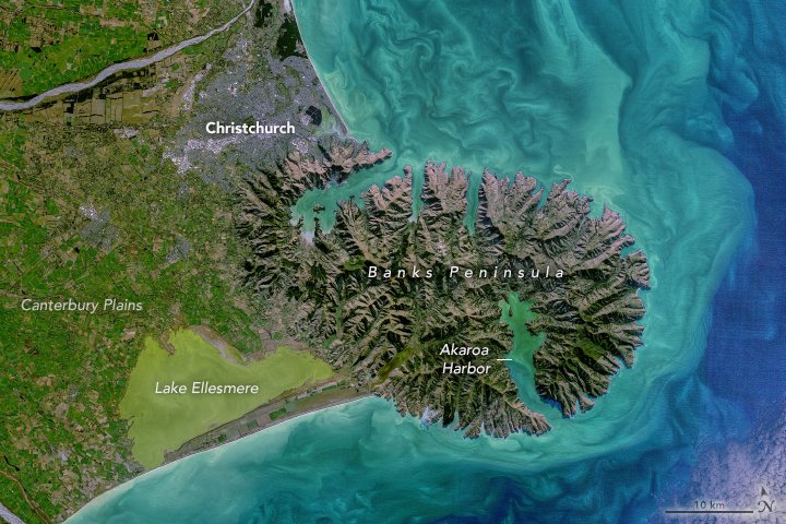
Banks Peninsula
Image via Wikimedia Commons (author and licence on the file page).

Banks Peninsula

Pen/cape · 343 km²

Banks Peninsula is a pen/cape in Oceania (New Zealand), covering an estimated 343 km².

Banks Peninsula (Māori: Te Pātaka o Rākaihautū) is a rocky peninsula on the east coast of the South Island of New Zealand that was formed by two now-extinct volcanoes. It has an area of approximately 1,200 square kilometres (450 sq mi). It includes two large deep-water harbours – Lyttelton Harbour and Akaroa Harbour – and many smaller bays and coves. The South Island's largest city, Christchurch, is immediately north of the peninsula, which is administered by Christchurch City Council. The main settlements are Lyttelton and Akaroa. The peninsula's economy is based on fisheries, farming and tourism.

Māori were the first people to visit, and settle, the peninsula. The already sparse population was reduced further following massacres by raiding parties of North Island Māori in 1830 and 1832. In 1770, explorer James Cook became the first European to sight the peninsula, which he mistook for an island, naming it after his ship's botanist Joseph Banks. From the 1830s, European whalers set up shore-based stations in some of the bays and harbours.

Adapted from Wikipedia: Banks Peninsula (CC BY-SA 4.0).

Feature class
Pen/cape
Mapped extent
343 km²
Size rank
#193 of 231 landforms
Region
Oceania
Subregion
New Zealand
Coordinates
-43.8598°, 172.9590°
Summits:
Tapuaenuku (2,885 m), Aoraki/Mount Cook (3,754 m), Mount Anglem (980 m)
Ranges:
Southern Alps (Oceania), Australian Alps (Oceania)
Settlements:
Christchurch (45 km), Timaru (149 km), Blenheim (273 km)

View on the live map

More about Banks Peninsula

Geography

Banks Peninsula forms the most prominent volcanic feature of the South Island, similar to – but more than twice as large as – the older Dunedin Volcano (Otago Peninsula and Harbour) 350 kilometres (220 mi) to the southwest. Geologically, the peninsula comprises the eroded remnants of two large shield volcanoes (Lyttelton formed first, then Akaroa), and the smaller Mount Herbert Volcanic Group. These formed due to intraplate volcanism between approximately eleven and eight million years ago (Miocene) on a continental crust. The peninsula formed as offshore islands, with the volcanoes reaching to about 1,500 m above sea level. Two dominant craters formed Lyttelton and Akaroa Harbours.

History

According to tradition, the first Māori settlers of the area now known as Banks Peninsula were the Waitaha, led by their founding ancestor Rākaihautū. The Māori name for the peninsula is Te Pātaka o Rākaihautū (The Storehouse of Rākaihautū) in recognition of his deeds and the abundance of mahinga kai (foods of the forests, sea, rivers and skies). They were followed by Kāti Māmoe, and then the Ngāi Tahu hapū Ngāi Tūhaitara, who arrived in the 1730s.

The first European sighting of the peninsula was on 17 February 1770 by Captain James Cook and crew during Cook's first circumnavigation of New Zealand. Cook described the land as "of a circular figure... of a very broken uneven surface and [having] more the appearance of barrenness than fertility."

Economy

Agriculture has been the main economic activity on Banks Peninsula historically. Mussel farming is carried out at several sites off the coast. Following the major earthquakes of 2010 and 2011, which affected Christchurch and Lyttelton (the harbour serving Christchurch), cruise ships were diverted to Akaroa Harbour.

Sections adapted from Wikipedia: Banks Peninsula (CC BY-SA 4.0).

Banks Peninsula: Key Facts

Key facts about Banks Peninsula
OnPacific Ocean

Facts from Wikidata Q806836 (CC0).

Otago Peninsula
Image via Wikimedia Commons (author and licence on the file page).

Otago Peninsula

Pen/cape · 182 km²

Otago Peninsula is a pen/cape in Oceania (New Zealand), covering an estimated 182 km².

The Otago Peninsula (Māori: Muaūpoko) is a long, hilly indented finger of land that forms the easternmost part of Dunedin, New Zealand. Volcanic in origin, it forms one wall of the eroded valley that now forms Otago Harbour. The peninsula lies southeast of Otago Harbour and runs parallel to the mainland for 20 km, with a maximum width of 9 km. It is joined to the mainland at the south-west end by a narrow isthmus about 1.5 km wide.

The suburbs of Dunedin encroach onto the western end of the peninsula, and seven townships and communities lie along the harbourside shore. The majority of the land is sparsely populated and occupied by steep open pasture. The peninsula is home to many species of wildlife, notably seabirds, pinnipeds, and penguins; several ecotourism businesses operate in the area.

Adapted from Wikipedia: Otago Peninsula (CC BY-SA 4.0).

Feature class
Pen/cape
Mapped extent
182 km²
Size rank
#202 of 231 landforms
Region
Oceania
Subregion
New Zealand
Coordinates
-45.8252°, 170.6815°
Summits:
Mount Anglem (980 m), Aoraki/Mount Cook (3,754 m), Tapuaenuku (2,885 m)
Ranges:
Southern Alps (Oceania), Australian Alps (Oceania)
Settlements:
Dunedin (16 km), Timaru (165 km), Invercargill (190 km)

View on the live map

More about Otago Peninsula

Geography

The peninsula was formed at the same time as the hills facing it across the harbour, as part of the large, long-extinct Dunedin Volcano. Several of the peninsula's peaks demonstrate these volcanic origins, notably Hereweka which was named 'Harbour Cone' by pākehā settlers. These rocks were built up between 13 and 10 million years ago.

Much of the peninsula is steep hill country, with the highest points being Mount Charles (408m), Highcliff (381m), and Sandymount (320m). Two tidal inlets lie on the Pacific coast of the peninsula: Hoopers Inlet and Papanui Inlet. Between them is the headland of Cape Saunders. Nearby natural features include the 250-metre-high cliffs of Lovers' Leap and The Chasm.

History

New Zealand was first settled by humans around 1300 AD, and in the South Island, people concentrated on the east coast. In the Archaic (moa-hunting) period, the Otago Peninsula was a relatively densely occupied area at the centre of the country's most populous region.

A map of recorded Māori archaeological sites for the Otago Conservancy shows many more on the Otago Peninsula than elsewhere in the region. Another showing only those of the Archaic period shows sites clustered on the peninsula and along the coast across the harbour to the west and north.

Natural history

Various species of endemic, rare, and endangered wildlife have been confirmed in the vicinity of Otago Peninsula both on land and at sea. Jewelled geckos are known from the area. Giant moa were historically seen on the peninsula. Endangered ocean megafauna such as basking sharks, great white sharks, and leatherback turtles have been confirmed along Otago coasts.

There is a diversity of flora and fauna on the Otago Peninsula. Birds observed include the endangered yellow-eyed penguin, Megadyptes antipodes, little penguin, shags, and the northern royal albatross. The albatross' breeding colony on Taiaroa Head is the only one in the world close to large-scale human cultivation and habitation.

Sections adapted from Wikipedia: Otago Peninsula (CC BY-SA 4.0).

Otago Peninsula: Key Facts

Key facts about Otago Peninsula
OnPacific Ocean

Facts from Wikidata Q43849 (CC0).

More on New Zealand

Quick Answers

What is the largest landform in New Zealand?
N.I. Volcanic Plateau, at 3,955 km². Fiordland is second at 2,908 km². Rankings cover the mountain ranges, deserts and other landforms indexed in YearMaps.
How many mountain ranges, deserts and other landforms are there in New Zealand?
YearMaps lists 7 mountain ranges, deserts and other landforms for New Zealand. This is the number mapped in the atlas, not an official national count.