Skip to content
YearMaps
Bolivia · Landforms

Mountain Ranges, Deserts and Landforms of Bolivia

South America is the largest of the 11 mountain ranges, deserts and other landforms recorded for Bolivia, at 17.91M km², ahead of Amazon Basin at 4.65M km². The full list follows.

How this list is built: Ranked by mapped area. Covers mountain ranges, deserts, plateaus, named glaciers, plains, basins, peninsulas and capes. One that crosses a border is listed under every country it lies in, with the area of the whole feature. It covers the mountain ranges, deserts and other landforms indexed in YearMaps, drawn from open geospatial data, and is not an exhaustive national register.

Landforms Listed
11
Top Ranked
17.91M km²
South America
Second
4.65M km²
Amazon Basin
Profiled Below
5
Photo, encyclopedia text and figures
Mountain Ranges, Deserts and Landforms of Bolivia
#NameArea
1South America17.91M km²
2Amazon Basin4.65M km²
3Gran Chaco690,714 km²
4Andes549,211 km²
5Altiplano339,339 km²
6Yungas166,334 km²
7Planalto Do Mato Grosso162,718 km²
8Pantanal129,097 km²
9Cordillera Real53,365 km²
10Cordillera Oriental24,985 km²
11Salar de Uyuni15,502 km²

The Landforms of Bolivia in Detail

The 5 mountain ranges, deserts and other landforms above that have an encyclopedia article, in the same order, each with its photograph, figures and the places around it.

South America
Image via Wikimedia Commons (author and licence on the file page).

South America

Continent · 17.91M km²

South America is a continent in South America, covering an estimated 17.91M km². It extends across Brazil, Argentina, Chile, Guyana, Venezuela, Ecuador, Suriname, Colombia, Bolivia, Paraguay, Uruguay, France and Peru. It is the 4th-largest of the 231 landforms with a mapped extent in YearMaps.

South America is a continent entirely in the Western Hemisphere and most in the Southern Hemisphere, with a considerably smaller portion in the Northern Hemisphere. It can also be described as the southern subregion of the Americas.

South America is bordered on the west by the Pacific Ocean, on the north and east by the Atlantic Ocean, and on the south by the Drake Passage; North America, the Caribbean Sea lying to the northwest, and the Antarctic Circle, Antarctica, and the Antarctic Peninsula to the south.

The continent includes twelve sovereign countries: Argentina, Bolivia, Brazil, Chile, Colombia, Ecuador, Guyana, Paraguay, Peru, Suriname, Uruguay, and Venezuela; two dependent territories: the Falkland Islands and South Georgia and the South Sandwich Islands; and one internal territory: French Guiana.

The Caribbean South America ABC islands (Aruba, Bonaire, and Curaçao) and Trinidad and Tobago are geologically located on the South-American continental shelf, and thus may be considered part of South America as well.

Adapted from Wikipedia: South America (CC BY-SA 4.0).

Feature class
Continent
Mapped extent
17.91M km²
Size rank
#4 of 231 landforms
Region
South America
Countries
Brazil, Argentina, Chile, Guyana, Venezuela, Ecuador, Suriname, Colombia, Bolivia, Paraguay, Uruguay, France, Peru
Coordinates
-4.1242°, -64.8745°
Summits:
Nevado Illimani (6,402 m), Nevado Sajama (6,542 m)
Ranges:
Wilhelmina Gebergte (South America), Tumuc-Humac Mountains (South America)
Settlements:
Santa Ana (57 km), Trinidad (184 km), Riberalta (263 km)

View on the live map

More about South America

Geography

South America occupies the southern portion of the Americas. The continent is generally delimited on the northwest by the Darién watershed along the Colombia–Panama border, although some may consider the border instead to be the Panama Canal. Geopolitically and geographically, all of Panama – including the segment east of the Panama Canal in the isthmus – is typically included in North America alone and among the countries of Central America. Almost all of mainland South America sits on the South American Plate.

History

South America is thought to have been first inhabited by humans when people were crossing the Bering Land Bridge (now the Bering Strait) at least 15,000 years ago from the territory that is present-day Russia. They migrated south through North America, and eventually reached South America through the Isthmus of Panama.

Amongst the oldest evidence for human presence in South America is the Monte Verde II site in Chile, suggested to date to around 14,500 years ago. From around 13,000 years ago, the Fishtail projectile point style became widespread across South America, with its disappearance around 11,000 years ago coincident with the disappearance of South America's megafauna.

Economy

Since 1930, the continent has experienced growth and diversification in most economic sectors. Most agricultural and livestock products are destined for the domestic market and local consumption. However, the export of agricultural products is essential for the balance of trade in most countries.

The main agrarian crops are export crops, such as soy and wheat. The production of staple foods such as vegetables, corn or beans is large, but focused on domestic consumption. Livestock raising for meat exports is significant in Argentina, Paraguay, Uruguay and Colombia. In tropical regions the most important crops are coffee, cocoa and bananas, mainly in Brazil, Colombia and Ecuador.

Sections adapted from Wikipedia: South America (CC BY-SA 4.0).

South America: Key Facts

Key facts about South America
Area17,461,112 km²
Highest pointAconcagua
OnAtlantic Ocean, Pacific Ocean

Facts from Wikidata Q18 (CC0).

Altiplano
Image via Wikimedia Commons (author and licence on the file page).

Altiplano

Plateau · 339,339 km²

Altiplano is a plateau in South America, covering an estimated 339,339 km². It extends across Bolivia, Argentina, Peru and Chile. It is the 12th-largest of the 69 plateaus with a mapped extent in YearMaps.

The Altiplano (Spanish for "high plain"), Collao (Quechua and Aymara: Qullaw, meaning "place of the Qulla") or Andean Plateau is a plateau in west-central South America. Located at the latitude of the widest part of the north–south-trending Andes, it is the most extensive high plateau on Earth outside Tibet. The bulk of the Altiplano lies in Bolivia, but its northern parts lie in Peru, its southwestern fringes lie in Chile, and it extends into Argentina.

Many towns and several cities are on the plateau, including El Alto and Oruro in Bolivia and Juliaca and Puno in Peru. The northeastern part of the Altiplano is more humid than the southwestern part, which has several salares (salt flats), due to its aridity. At the Bolivia–Peru border lies Lake Titicaca, the largest lake in South America. Farther south, in Bolivia, Lake Poopó existed until recently, but by December 2015, it had completely dried up, and was declared defunct. Whether that lake, which had been the second-largest in Bolivia, can be restored is unclear.

The Altiplano was the site of several pre-Columbian cultures, including the Chiripa, Tiwanaku, and the Inca Empire. Spain conquered the region in the 16th century.

Adapted from Wikipedia: Altiplano (CC BY-SA 4.0).

Feature class
Plateau
Mapped extent
339,339 km²
Size rank
#12 of 69 plateaus
Region
South America
Countries
Bolivia, Argentina, Peru, Chile
Coordinates
-18.2915°, -68.2044°
Summits:
Nevado Sajama (6,542 m), Nevado Illimani (6,402 m)
Ranges:
Serra Geral (South America), Cuchilla Grande (South America)
Settlements:
Oruro (138 km), Llallagua (147 km), Potosí (236 km)

View on the live map

More about Altiplano

Geography

The Altiplano is an area of inland drainage (endorheism) lying in the central Andes, occupying parts of northern Chile, western Bolivia, southern Peru, and northwest Argentina. Its elevation averages about 3,750 meters (12,300 feet), slightly less than that of the Tibetan Plateau. Unlike conditions in Tibet, the Altiplano is dominated by massive active volcanoes of the Central Volcanic Zone to the west, such as Ampato (6288 m), Tutupaca (5,816 m), Parinacota (6348 m), Guallatiri (6071 m), Paruma (5,728 m), Uturunku (6,008 m), and Licancabur (5,916 m), and the Cordillera Real in the northeast with Illampu (6,368 m), Huayna Potosí (6,088 m), Janq'u Uma (6,427 m) and Illimani (6,438 m).

Geology

Existence of weaknesses in the Earth's crust prior to tectonic shortening: Such weaknesses would cause the partition of tectonic deformation and uplift into the eastern and western cordillera, leaving the necessary space for the formation of the altiplano basin.

Magmatic processes rooted in the asthenosphere might have contributed to uplift of the plateau.

Climate has controlled the spatial distribution of erosion and sediment deposition, controlling the lubrication along the subducting Nazca Plate, hence influencing the transmission of tectonic forces into South America.

Climate

Due to its average elevation exceeding 3,800 meters above sea level, the climate of the Altiplano is cold and dry, characterized by marked daily temperature fluctuations; the region is sometimes used to identify the altitude zone and the type of climate that prevails within it is colder than that of the tierra fría, but not as cold as that of the tierra helada. Scientists classify the latter as commencing at an elevation around 4,500 meters (or about 15,000 feet). Alternate names used in place of altiplano in this context include puna and páramos.

Sections adapted from Wikipedia: Altiplano (CC BY-SA 4.0).

Yungas
Image via Wikimedia Commons (author and licence on the file page).

Yungas

Foothills · 166,334 km²

Yungas is a foothills in South America, covering an estimated 166,334 km².

The Yungas (Aymara yunka; 'warm or temperate Andes or earth', Quechua yunka; 'warm area on the slopes of the Andes') is a bioregion of a narrow band of forest along the eastern slope of the Andes Mountains from Peru and Bolivia, and extends into the Argentine Northwest at the slope of the Andes pre-cordillera. It is a transitional zone between the Andean highlands and the eastern forests. Like the surrounding areas, the Yungas belong to the Neotropical realm; the climate is quite rainy, humid, and warm.

Adapted from Wikipedia: Yungas (CC BY-SA 4.0).

Feature class
Foothills
Mapped extent
166,334 km²
Size rank
#49 of 231 landforms
Region
South America
Coordinates
-13.4000°, -65.9964°
Summits:
Nevado Illimani (6,402 m), Nevado Sajama (6,542 m), Nevado Coropuna (6,425 m)
Ranges:
Wilhelmina Gebergte (South America), Tumuc-Humac Mountains (South America)
Settlements:
Santa Ana (60 km), Trinidad (198 km), Riberalta (269 km)

View on the live map

More about Yungas

History

During the Inca Empire, the term yunga referred to both the western and eastern slopes of the Andes and their inhabitants. In the Spanish colonial era, it became primarily associated with the western foothills near the desert coast and the local Indians. Today, yunga can refer to the lower slopes on both sides of the Andes, though yungas mostly denotes the eastern foothills between the Andes and the Amazon basin, with both having mostly lost their ethnic associations.

Sections adapted from Wikipedia: Yungas (CC BY-SA 4.0).

Pantanal
Image via Wikimedia Commons (author and licence on the file page).

Pantanal

Wetlands · 129,097 km²

Pantanal is a wetlands in South America, covering an estimated 129,097 km². It extends across Brazil, Bolivia and Paraguay.

The Pantanal (Portuguese pronunciation: [pɐ̃taˈnaw], Spanish pronunciation: [pantaˈnal]) is a natural region encompassing the world's largest tropical wetland area, and the world's largest flooded grasslands. It is located mostly within the Brazilian state of Mato Grosso do Sul, but it extends into Mato Grosso and portions of Bolivia and Paraguay. It sprawls over an area estimated at between 140,000 and 195,000 km2 (54,000 and 75,000 sq mi). Various subregional ecosystems exist, each with distinct hydrological, geological, and ecological characteristics; up to 12 of them have been defined.

Roughly 80% of the Pantanal floodplains are submerged during the rainy seasons, nurturing a biologically diverse collection of aquatic plants and helping to support a dense array of animal species.

Adapted from Wikipedia: Pantanal (CC BY-SA 4.0).

Feature class
Wetlands
Mapped extent
129,097 km²
Size rank
#56 of 231 landforms
Region
South America
Countries
Brazil, Bolivia, Paraguay
Coordinates
-18.3780°, -56.2597°
Summits:
Nevado Illimani (6,402 m), Nevado Sajama (6,542 m)
Ranges:
Serra Geral (South America), Serra do Mar (South America)
Settlements:
Puerto Suárez (131 km), San Ignacio (352 km), Santa Cruz (554 km)

View on the live map

More about Pantanal

Geography and geology

The Pantanal covers about 140,000–160,000 km2 (54,000–62,000 sq mi) of gently sloped basin that receives runoff from the upland areas (the Planalto highlands) and slowly releases the water through the Paraguay River and tributaries. The formation is a result of the large, concave, pre-Andean depression of the Earth's crust, related to the Andean orogeny of the Tertiary. It constitutes an enormous internal river delta, in which several rivers flowing from the surrounding plateau merge, depositing their sediments and erosion residues, which have been filling the large depression area of the Pantanal. This area is also one of the distinct physiographic provinces of the larger Parana-Paraguay Plain area, which encompasses a total of 1.5×10^6 km2 (580,000 sq mi).

Sections adapted from Wikipedia: Pantanal (CC BY-SA 4.0).

Pantanal: Key Facts

Key facts about Pantanal
Area879 km²

Facts from Wikidata Q157603 (CC0).

Salar de Uyuni
Image via Wikimedia Commons (author and licence on the file page).

Salar de Uyuni

Desert · 15,502 km²

Salar de Uyuni is a desert in South America, covering an estimated 15,502 km².

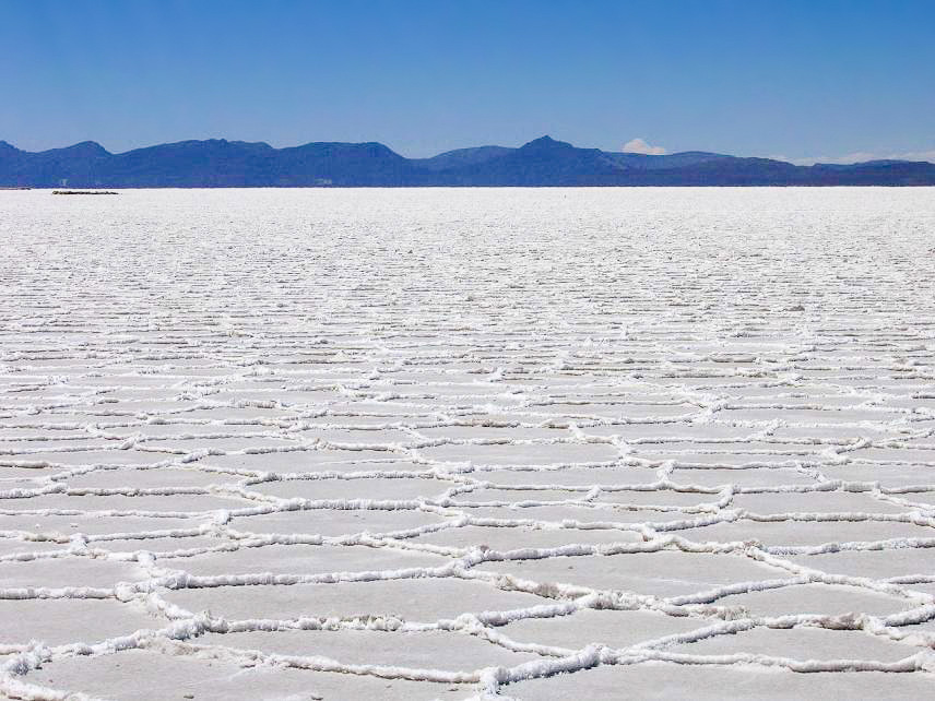
Salar de Uyuni is the largest salt flat in the world, with an area of approximately 10,582 square kilometres (4,086 mi2). It is situated in southwestern Bolivia, within the Daniel Campos Province of the Potosí Department, near the crest of the Andes Mountains, at an elevation of 3,656 m (11,995 ft) above sea level.

The Salar was formed as a result of transformations of seven Late Pleistocene lakes whose progressive desiccation led to the accumulation of extensive evaporitic salt deposits. It is now covered by an 8-meter-thick layer of salt, which is extremely flat. The average elevation varies by less than one meter over the entire area of the Salar. The crust serves as a source of salt and covers a pool of brine, which is exceptionally rich in lithium. The large area, clear skies, and exceptional flatness of the surface make the Salar ideal for calibrating the altimeters of Earth observation satellites. Following rain, a thin layer of dead calm water transforms the flat into the world's largest mirror, 129 km (80 miles) across.

The Salar serves as the major transport route across the Bolivian Altiplano and is a prime breeding ground for several species of flamingos.

Adapted from Wikipedia: Salar de Uyuni (CC BY-SA 4.0).

Feature class
Desert
Mapped extent
15,502 km²
Size rank
#41 of 58 deserts
Region
South America
Coordinates
-20.2494°, -67.3930°
Summits:
Aucanquilcha (6,176 m), Nevado Sajama (6,542 m), Nevado Illimani (6,402 m)
Ranges:
Serra Geral (South America), Cuchilla Grande (South America)
Settlements:
Potosí (188 km), Tupiza (218 km), Llallagua (218 km)

View on the live map

More about Salar de Uyuni

Formation, geology, and climate

The Salar de Uyuni is part of the Altiplano of Bolivia in South America. The Altiplano is a high plateau, which was formed during the uplift of the Andes mountains. The plateau includes fresh and saltwater lakes as well as salt flats and is endorheic.

The geological history of the Salar is associated with a sequential transformation between several vast lakes. Some 30,000 to 42,000 years ago, the area was part of a giant prehistoric lake, Lake Minchin. Its age was estimated by radiocarbon dating shells from outcropping sediments and carbonate reefs and varies between reported studies.

Tourism

Salar de Uyuni is a popular tourist destination, and consequently, a number of hotels have been built in the area. Due to a lack of conventional construction materials, many of them are almost entirely (walls, roof, furniture) built with salt blocks cut from the Salar. The first such hotel, named Palacio de Sal, was erected in 1993–1995 in the middle of the salt flat, and soon became a popular tourist destination. However, its location in the center of a desert caused sanitation problems, as most waste had to be collected manually. Mismanagement caused serious environmental pollution, and the hotel had to be dismantled in 2002.

at the eastern edge of Salar de Uyuni, 25 km away from the town of Uyuni. The sanitary system has been restructured to comply with the government regulations.

Sections adapted from Wikipedia: Salar de Uyuni (CC BY-SA 4.0).

Salar de Uyuni: Key Facts

Key facts about Salar de Uyuni
Area10,582 km²

Facts from Wikidata Q76122 (CC0).

More on Bolivia

Quick Answers

What is the largest landform in Bolivia?
South America, at 17.91M km². Amazon Basin is second at 4.65M km². Rankings cover the mountain ranges, deserts and other landforms indexed in YearMaps.
How many mountain ranges, deserts and other landforms are there in Bolivia?
YearMaps lists 11 mountain ranges, deserts and other landforms for Bolivia. This is the number mapped in the atlas, not an official national count.