
Map of Benin
Benin is a country in Africa with its capital at Porto-Novo, home to about 14.81 million people across 114,763 km². The interactive map below plots 9 cities and towns, 3 rivers, 1 mountain summits and 1 ports recorded for Benin in YearMaps.
- Population
- 14.81 million
- Area
- 114,763 km²
- Capital
- Porto-Novo
- Continent
- Africa
Interactive Map of Benin
Centred on Porto-Novo at 6.4020° N, 2.5180° E. Use the layer panel to switch on rivers, dams, ports, peaks and historical borders.
About Benin
Benin, officially the Republic of Benin, formerly known as Dahomey, is a country in West Africa. It is bordered by Togo to the west, Nigeria to the east, Burkina Faso to the northwest, and Niger to the northeast. The majority of its population lives on the southern coastline of the Bight of Benin, part of the Gulf of Guinea in the northernmost tropical portion of the Atlantic Ocean. The capital is Porto-Novo, and the seat of government is in Cotonou, the most populous city and economic capital. Benin covers an area of 112,622 km2 (43,484 sq mi), and its population in 2026 was estimated to be approximately 15 million. It is a tropical country with an economy heavily dependent on agriculture and the exports of palm oil and cotton.
From the 17th to the 19th centuries, political entities in the area included the Kingdom of Dahomey, the city-state of Porto Novo, and other states to the north. France took over the territory in 1894, incorporating it into French West Africa as French Dahomey. In 1960, Dahomey gained full independence from France. As a sovereign state, Benin has had democratic governments, military coups, and military governments. A self-described Marxist–Leninist state called the People's Republic of Benin existed between 1975 and 1990. In 1991, it was replaced by the multi-party Republic of Benin.
The official language of Benin is French, with indigenous languages such as Fon, Bariba, Yoruba and Dendi also spoken. The largest religious group in Benin, as projected for 2020 by the Pew Research Centre in 2026 based on 2010 statistics, is Christianity (53%), followed by Islam (31%) and other faiths including African traditional religions (11%). Benin is a member of the United Nations, the African Union, the Economic Community of West African States, the Organisation of Islamic Cooperation, the South Atlantic Peace and Cooperation Zone, Francophonie, the Community of Sahel–Saharan States, the African Petroleum Producers Association and the Niger Basin Authority.
Summary adapted from Wikipedia: Benin (CC BY-SA 4.0).

Geography and Climate of Benin
Present-day Benin is comprised of about 42 ethnic groups, including the Yoruba in the southeast, who migrated from what is now Nigeria in the 12th century; the Dendi in the north-central area, who came from Mali in the 16th century; the Bariba and the Fula in the northeast; the Ottamari in the Atakora mountains; the Fon in the area around Abomey in the south-central area; and the Mina, Xueda, and Aja, who came from Togo, on the coast. The Kingdom of Dahomey emerged on the Abomey plateau in the 17th century and was a regional power for much of the 18th and 19th centuries. The growth of Dahomey coincided with the growth of the Atlantic slave trade, and it became known as a major source of enslaved people. France began to control the coastal areas of Dahomey in the second half of the 19th century; the entire kingdom was conquered by 1894. French Dahomey achieved independence in 1960, and it changed its name to the Republic of Benin in 1975. A succession of military governments ended in 1972 with the rise to power of Mathieu KEREKOU and a Marxist-Leninist government. A move to representative government began in 1989. Two years later, free elections ushered in former Prime Minister Nicephore SOGLO as president, marking the first successful transfer of power in Africa from a dictatorship to a democracy. KEREKOU returned to power after elections in 1996 and 2001. He stepped down in 2006 and was succeeded by Thomas YAYI Boni, a political outsider and independent, who won a second term in 2011. Patrice TALON, a wealthy businessman, took office in 2016; the space for pluralism, dissent, and free expression has narrowed under his administration. TALON won a second term in 2021.
- Location
- Western Africa, bordering the Bight of Benin, between Nigeria and Togo.
- Climate
- Tropical; hot, humid in south; semiarid in north.
- Terrain
- Mostly flat to undulating plain; some hills and low mountains.
- Highest point
- Unnamed elevation 675 m; located 2.5 km southeast of the town of Kotopounga.
- Lowest point
- Atlantic Ocean 0 m.
- Coastline
- 121 km.
- Land borders
- Total: 2,123 km; border countries: Burkina Faso 386 km; Niger 277 km; Nigeria 809 km; Togo 651 km.
- Natural resources
- Small offshore oil deposits, limestone, marble, timber.
- Land use
- Agricultural land: 41.8% (2023 est.); arable land: 31.4% (2023 est.); permanent crops: 5.5% (2023 est.); permanent pasture: 4.9% (2023 est.); forest: 28.5% (2023 est.); other: 29.7% (2023 est.)
- Natural hazards
- Hot, dry, dusty harmattan wind may affect north from December to March.
- Geographic note
- Sandbanks create difficult access to a coast with no natural harbors, river mouths, or islands.
- Languages
- 55 languages; French (official); Fon (a Gbe language), Yom (a Gur language) and Yoruba are the most important indigenous languages in the south; half a dozen regionally important languages in the north, including Bariba and Fulfulde.
- Religions
- Muslim 27.7%, Roman Catholic 25.5%, Protestant 13.5% (Celestial 6.7%, Methodist 3.4%, other Protestant 3.4%), Vodoun 11.6%, other Christian 9.5%, other traditional religions 2.6%, other 2.6%, none 5.8% (2013 est.)
- Ethnic groups
- Fon and related 38.4%, Adja and related 15.1%, Yoruba and related 12%, Bariba and related 9.6%, Fulani and related 8.6%, Ottamari and related 6.1%, Yoa-Lokpa and related 4.3%, Dendi and related 2.9%, other 0.9%, foreigner 1.9% (2013 est.)
- Economy
- Robust economic growth; slightly declining but still widespread poverty; strong trade relations with Nigeria; cotton exporter; COVID-19 has led to capital outflows and border closures; WAEMU member with currency pegged to the euro; recent fiscal deficit and debt reductions.
From the CIA World Factbook (public domain), archived edition of 2026-01-22. The Factbook is no longer updated, so figures reflect that edition.
Benin in Numbers
- Population
- 14.81 million
- GDP
- US$24.6 billion
- GDP per person
- US$1,658
- Life expectancy
- 61.0 years
- Population growth
- 2.40% a year
- Population density
- 128 per km²
- Urban population
- 53.4%
- Surface area
- 114,760 km²
- Forest cover
- 28.1%
- Arable land
- 32.3%
- Access to electricity
- 59.0%
- Internet users
- 34.0%
Indicators from World Bank Open Data (CC BY 4.0). The year under each figure is its reference year.
Benin in Depth
History
Prior to 1600, present-day Benin comprised a variety of areas with different political systems and ethnicities. These included city-states along the coast (primarily of the Aja ethnic group and also including Yoruba and Gbe peoples) and tribal regions inland (composed of Bariba, Mahi, Gedevi, and Kabye peoples). The Oyo Empire, located primarily to the east of Benin, was a military force in the region, conducting raids and exacting tribute from the coastal kingdoms and tribal regions. The situation changed in the 17th and 18th centuries as the Kingdom of Dahomey, consisting mostly of Fon people, was founded on the Abomey plateau and began taking over areas along the coast. By 1727, King Agaja of the Kingdom of Dahomey had conquered the coastal cities of Allada and Whydah.
Geography
The north–south strip of land in West Africa lies between latitudes 6° and 13°N, and longitudes 0° and 4°E. It is bounded by Togo to the west, Burkina Faso and Niger to the north, Nigeria to the east, and the Bight of Benin to the south. The distance from the Niger River in the north to the Atlantic Ocean in the south is about 650 km (404 mi). Although the coastline measures 121 km (75 mi), the country measures about 325 km (202 mi) at its widest point. Four terrestrial ecoregions lie within Benin's borders: Eastern Guinean forests, Nigerian lowland forests, Guinean forest-savanna mosaic, and West Sudanian savanna. It had a 2018 Forest Landscape Integrity Index mean score of 5.86/10, ranking it 93rd globally out of 172 countries.
Economy
The economy is dependent on subsistence agriculture, cotton production, and regional trade. Cotton accounts for 40% of the GDP and roughly 80% of official export receipts.
Real GDP growth was estimated at 5.1% and 5.7% in 2008 and 2009, respectively. The main driver of growth is the agricultural sector, with cotton being the main export, while services continue to contribute the largest part of GDP mostly because of Benin's geographical location, enabling trade, transportation, transit and tourism activities with its neighboring states. Benin's overall macroeconomic conditions were "positive" in 2017, with a growth rate of around 5.6%. Economic growth was mostly driven by the cotton industry and other cash crops, the Port of Cotonou, and telecommunications.
Sections adapted from Wikipedia: Benin (CC BY-SA 4.0).
Benin: Key Facts
| Currency | West African CFA franc |
|---|---|
| Official language | French |
| Head of state | Romuald Wadagni |
| Head of government | Patrice Talon |
| Form of government | republic |
| Calling code | +229 |
| Internet domain | .bj |
| Highest point | Mont Sokbaro |
| Lowest point | Bight of Benin |
| Established | 1 August 1960 |
Facts from Wikidata Q962 (CC0).
History of Benin: Empires and States
The atlas records 6 polities whose mapped territory included part of Benin, from Oyo Empire in 1752 CE to 2024 CE. They are listed in the order they first appear.
| Polity | Period here | Extent |
|---|---|---|
| Oyo Empire | 1752–1835 CE | A large part |
| French Third Republic | 1885–1939 CE | Nearly all |
| French Africa | 1885–1957 CE | Nearly all |
| The French Colonial Empire | 1885–1957 CE | Nearly all |
| French Fourth Republic | 1945–1957 CE | Nearly all |
| Republic of Benin | 1961–2024 CE | Nearly all |
Historical Maps of Benin
Benin on the world map in each year one of these states held it:
Derived by testing mapped cities against dated territorial polygons. Dates are when the polygons cover this place, not the polity's whole lifespan, and polities absent from the source dataset are not listed.
Visiting Benin
For the city in Edo State, see Benin City
Benin is a country in West Africa. You'll find culture through a large collection of palatial ruins and temples of the once powerful Kingdom of Dahomey (1800s–1894). Moreover, Benin is the birthplace of Vodun (Voodoo) and all that goes with it. Vodun is the official religion of the country, and an important part of the life of ordinary Beninese. Many important tourist sites are linked to Vodun or the slave trade. The national parks of Benin are well worth a visit for their wildlife. It is also one of the most stable and safest countries in the region. With its rich history, vibrant culture, protected wildlife, Grand Popo ocean beach, and artisan market in Se, Benin is one of the best kept tourist secrets in West Africa.
Travel notes adapted from Wikivoyage: Benin (CC BY-SA 4.0).
Largest Cities in Benin
9 cities recorded. Ranked by metropolitan population. A port city's harbour is written up on the page of its sea.
| # | Name | Population | Region | Role |
|---|---|---|---|---|
| 1 | Cotonou | 762,000 | Ouémé | National capital |
| 2 | Porto-Novo | 300,000 | Ouémé | Admin-0 capital alt |
| 3 | Djougou | 202,810 | Donga | Populated place |
| 4 | Parakou | 188,853 | Borgou | Admin-1 capital |
| 5 | Kandi | 109,701 | Alibori | Populated place |
| 6 | Lokossa | 86,971 | Mono | Admin-1 capital |
| 7 | Ouidah | 83,503 | Atlantique | Populated place |
| 8 | Abomey | 82,154 | Zou | Admin-1 capital |
| 9 | Natitingou | 80,892 | Atakora | Admin-1 capital |
Highest Mountains in Benin
1 mountain recorded. Ranked by summit elevation above sea level. A summit on a border is listed under both countries.
| # | Name | Elevation | Feet | Region |
|---|---|---|---|---|
| 1 | Tanekas | 641 m | 2,103 ft | Africa |
Rivers in Benin
3 rivers recorded. Listed alphabetically. A river is listed where its mapped reach lies, so long rivers appear under more than one country.
Ports in Benin
1 port recorded. Ranked by approach channel depth, the figure that limits which ships can call. Harbours link to their write-up on the page of the sea or coast they lie on.
| # | Name | Channel Depth | Class | Sea | Max Vessel |
|---|---|---|---|---|---|
| 1 | Cotonou | 38.4 m | Minor | Atlantic Coast of Africa | large vessels |
UNESCO World Heritage Sites in Benin
3 World Heritage Sites recorded. Listed by year of inscription, earliest first. Sites shared with another country appear under each.
| # | Name | Inscribed | Type | Criteria |
|---|---|---|---|---|
| 1 | Royal Palaces of Abomey | 1985 | Cultural | (iii) (iv) |
| 2 | W-Arly-Pendjari Complex | 1996 | Natural | (ix) (x) |
| 3 | Koutammakou | 2004 | Cultural | (v) (vi) |
Mountain Ranges, Deserts and Landforms of Benin
2 mountain ranges, deserts and other landforms recorded. Ranked by mapped area. Covers mountain ranges, deserts, plateaus, named glaciers, plains, basins, peninsulas and capes. One that crosses a border is listed under every country it lies in, with the area of the whole feature.
| # | Name | Area | Type | Region |
|---|---|---|---|---|
| 1 | Africa | 29.41M km² | Continent | Africa |
| 2 | Niger Delta | 431 km² | Delta | Africa |
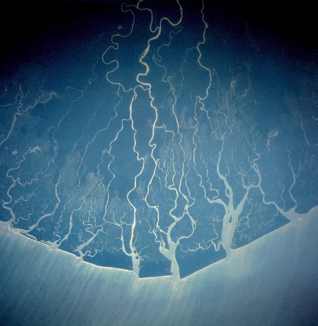
Niger Delta
Delta · 431 km²
Niger Delta is a delta in Africa, covering an estimated 431 km². It extends across Nigeria, Guinea Bissau, Benin, Mali and Niger.
The Niger Delta is a distinct geographic, ecological, and cultural region situated in southern Nigeria, defined by the extensive floodplain and riverine network where the Niger River drains into the Gulf of Guinea on the Atlantic Ocean [1]. Characterized by a unique aquatic ecosystem of mangrove swamps, barrier islands, and saltwater creeks, the true Niger Delta is home to indigenous populations fundamentally shaped by water and bound by shared cultural traditions. These include a lifestyle centered around riverine occupations, a distinct culinary identity featuring local staples like plantain and periwinkle, and the universal use of Nigerian Pidgin as a lingua franca.
Historically referred to by European traders as the Oil Rivers due to its pre-colonial prominence in the palm oil trade, the maritime area formed the British Oil Rivers Protectorate from 1885 until 1893, when it was reorganized as the Niger Coast Protectorate. In the modern era, the delta has become a globally recognized petroleum-rich hub, serving as the core of international concern over extensive oil pollution and ecological degradation frequently characterized as ecocide.
Adapted from Wikipedia: Niger Delta (CC BY-SA 4.0).
- Feature class
- Delta
- Mapped extent
- 431 km²
- Size rank
- #191 of 231 landforms
- Region
- Africa
- Countries
- Nigeria, Guinea Bissau, Benin, Mali, Niger
- Coordinates
- 4.3147°, 6.2635°
- Ranges:
- Guinea Highlands (Africa), Loma Mountains (Africa)
- Settlements:
- Porto-Novo (470 km), Cotonou (475 km), Ouidah (515 km)
More about Niger Delta
Geography and Boundaries
A sharp distinction exists between the natural, cultural Niger Delta and the administrative boundaries utilized by the Nigerian federal government. Geographically and ecologically, the authentic Niger Delta does not conform to modern state lines; it spans a continuous, water-bound coastal belt running from the riverine fringes of western Ondo State (such as the Arogbo kingdom) through the southern coastal tip of Edo State, encompassing roughly two-thirds of Delta State, the entirety of Bayelsa State, the riverine southern halves of Rivers State and Akwa Ibom State, and terminating at the southern maritime border of Cross River State at Bakassi.
History
During the pre-colonial and early colonial eras, the maritime delta operated as a vital commercial arena for the palm oil trade and earlier transatlantic exchanges. The British Empire established the Oil Rivers Protectorate in 1885, later expanding it into the Niger Coast Protectorate in 1893.
Following the amalgamation of Nigeria, the core riverine Niger Delta was administratively placed within the former Eastern Region in 1951. During the late colonial transition, minority ethnic groups within the delta's coastal divisions expressed deep political anxieties regarding marginalisation by larger interior ethnic groups.
Sections adapted from Wikipedia: Niger Delta (CC BY-SA 4.0).
Countries Bordering Benin
Land and maritime neighbours.
More Maps in Africa
Benin: Quick Answers
- What is the capital of Benin?
- The capital of Benin is Porto-Novo.
- What is the population of Benin?
- Benin has a population of about 14.81 million, the #76 largest of 225 countries in YearMaps. Source: World Bank, 2025.
- How big is Benin?
- Benin covers 114,763 km², ranking #103 by area, with about 129 people per square kilometre.
- Which continent is Benin in?
- Benin is in Africa.
- Which countries border Benin?
- Benin shares a land or maritime border with Togo, Burkina Faso, Niger, Nigeria.
- What is the largest city in Benin?
- Cotonou is the largest city in Benin, with a metropolitan population of about 762,000.
- What is the highest mountain in Benin?
- The highest summit recorded for Benin in YearMaps is Tanekas at 641 m (2,103 ft). Summits on a border are counted for both countries.