
UNESCO World Heritage Sites in Brazil
Brazil has 22 sites on the UNESCO World Heritage List (15 cultural and 7 natural), the first inscribed in 1980 (Historic Town of Ouro Preto). The map below plots every one of them alongside the rest of the List, and each site is written up in full further down the page.
- World Heritage Sites
- 22
- Cultural
- 15
- Natural and Mixed
- 7
- First Inscribed
- 1980
Map of World Heritage Sites in Brazil
CulturalNaturalMixedIn DangerLarge dots are in Brazil. Click a dot to read about the site.

Historic Town of Ouro Preto
Brazil · 20.3858° S, 43.5036° W · 2 km² · 43 km from Conselheiro Lafaiete
Founded at the end of the 17th century, Ouro Preto (Black Gold) was the focal point of the gold rush and Brazil’s golden age in the 18th century. With the exhaustion of the gold mines in the 19th century, the city’s influence declined but many churches, bridges and fountains remain as a testimony to its past prosperity and the exceptional talent of the Baroque sculptor Aleijadinho.
Description from the UNESCO World Heritage Centre (CC BY-SA IGO 3.0).
Why Historic Town of Ouro Preto Is Listed
- (i)
- A masterpiece of human creative genius.
- (iii)
- A unique testimony to a cultural tradition or civilisation.

Historic Centre of the Town of Olinda
Brazil · 8.0133° S, 34.8450° W · 2 km² · 2 km from Olinda
Founded in the 16th century by the Portuguese, the town’s history is linked to the sugar-cane industry. Rebuilt after being looted by the Dutch, its basic urban fabric dates from the 18th century. The harmonious balance between the buildings, gardens, 20 Baroque churches, convents and numerous small passos (chapels) all contribute to Olinda’s particular charm.
Description from the UNESCO World Heritage Centre (CC BY-SA IGO 3.0).
Why Historic Centre of the Town of Olinda Is Listed
- (ii)
- An important interchange of human values.
- (iv)
- An outstanding example of a type of building or landscape.

Historic Centre of Salvador da Bahia
Brazil · 12.9667° S, 38.5000° W · 2 km² · 2 km from Salvador
The Historic Center (US) or Centre (UK) (Portuguese: Centro Histórico) of Salvador de Bahia in Brazil, also known as the Pelourinho (Portuguese for "Pillory") or Pelô, is a historic neighborhood in western Salvador, Bahia. It was the city's center during the Portuguese colonial period and was named for the whipping post in its central plaza where enslaved people from Africa were publicly beaten as punishment for alleged infractions. The Historic Center is extremely rich in historical monuments dating from the 17th through the 19th centuries.
Designated a UNESCO World Heritage Site, the Largo do Pelourinho retains a vibrant repertoire of colonial Portuguese architecture, exemplified by the Mannerist decoration of the Cathedral of Salvador, the Baroque intricacy of the Church and Convent of São Francisco and the Church of the Third Order of Our Lady of the Rosary of the Black People. In addition, the Pelourinho remains a cultural hub for the Afro-Brazilian community, whose cuisine, architecture, religion and music exert a salient influence on the neighborhood and testify to the "empowerment and influence of Afro cultures" in the New World.
Adapted from Wikipedia: Historic Center of Salvador (CC BY-SA 4.0).
Why Historic Centre of Salvador da Bahia Is Listed
- (iv)
- An outstanding example of a type of building or landscape.
- (vi)
- A direct association with events, ideas or beliefs of universal significance.
More about Historic Centre of Salvador da Bahia
UNESCO's Description
As the first capital of Brazil, from 1549 to 1763, Salvador de Bahia witnessed the blending of European, African and Amerindian cultures. It was also, from 1558, the first slave market in the New World, with slaves arriving to work on the sugar plantations. The city has managed to preserve many outstanding Renaissance buildings. A special feature of the old town are the brightly coloured houses, often decorated with fine stucco-work.
From the UNESCO World Heritage Centre (CC BY-SA IGO 3.0).
History
The Church of the Holy See (Igreja da Sé), an integral part of the architectural set of the Historic Center, was demolished in 1933 along with four other blocks of buildings from the colonial and imperial periods. The Archbishop's Palace, connected to the church, remains. Debates over the destruction of historic sites in Salvador and elsewhere in Brazil led to the first attempts at federal-level protection of historic assets and eventually to the establishment of the National Institute of Historic and Artistic Heritage.
The Terreiro de Jesus, just north of Praça Municipal, is home to structures from the 17th to 19th century constructions.
Sections adapted from Wikipedia: Historic Center of Salvador (CC BY-SA 4.0).
Key Facts
| Established | 1549 |
|---|---|
| Area | 0.8 km² |
Facts from Wikidata Q5572706 (CC0).

Sanctuary of Bom Jesus de Matosinhos
Brazil · 20.5078° S, 43.8607° W · 19 km from Conselheiro Lafaiete
The Sanctuary of Bom Jesus de Matosinhos (Portuguese: Santuário do Bom Jesus de Matosinhos) is an 18th-century Roman Catholic basilica in Congonhas, Minas Gerais, Brazil. It was designed in the Baroque style with an Italian-inspired Rococo interior. The basilica is noted for its grand outdoor stairway with statues of Old Testament prophets. The interior has seven side chapels which illustrate the Stations of the Cross; each has a polychrome sculpture made by the artist Aleijadinho (b. 1730 or 1738 – 1814) and his assistants. They are considered masterpieces of an original, moving, and expressive form of Baroque art. The basilica was listed as a historic structure by the National Institute of Historic and Artistic Heritage (IPHAN) in 1939, and designated it as a UNESCO World Heritage Site in 1985.
Adapted from Wikipedia: Sanctuary of Bom Jesus de Matosinhos (CC BY-SA 4.0).
Why Sanctuary of Bom Jesus de Matosinhos Is Listed
- (i)
- A masterpiece of human creative genius.
- (iv)
- An outstanding example of a type of building or landscape.
More about Sanctuary of Bom Jesus de Matosinhos
UNESCO's Description
This sanctuary in Minais Gerais, south of Belo Horizonte was built in the second half of the 18th century. It consists of a church with a magnificent Rococo interior of Italian inspiration; an outdoor stairway decorated with statues of the prophets; and seven chapels illustrating the Stations of the Cross, in which the polychrome sculptures by Aleijadinho are masterpieces of a highly original, moving, expressive form of Baroque art.
From the UNESCO World Heritage Centre (CC BY-SA IGO 3.0).
History
The sanctuary was commissioned by Feliciano Mendes. Mendes made a promise to the Bom Jesus de Matosinhos after he recovered from a grave illness in 1757. When Mendes died in 1765, religious services started to be offered by the sanctuary. The sculpture of Bom Jesus at Congonhas do Campo is seen as a powerful vehicle of intercession. It was believed that prayers uttered in front of the sculpture have a good chance of being answered, and it became a famous pilgrimage site with to which people travelled to ask Jesus for help and assistance.
Sections adapted from Wikipedia: Sanctuary of Bom Jesus de Matosinhos (CC BY-SA 4.0).
Key Facts
| Established | 1757 |
|---|---|
| Area | 0 km² |
| Architectural style | Baroque |
Facts from Wikidata Q1595417 (CC0).

Iguaçu National Park
Brazil · 25.5000° S, 53.8000° W · 1,697 km² · 69 km from Cascavel
Iguaçu National Park (Portuguese: Parque Nacional do Iguaçu, pronounced [ˈpaʁki nasi.oˈnaw du iɡwaˈsu, - nasjoˈnaw -]) is a national park in Paraná State, Brazil. It comprises a total area of 185,262.5 hectares (457,794 acres) and a length of about 420 kilometers (260 mi), 300 kilometers (190 mi) of which are natural borders by bodies of water and the Argentine and Brazilian sides together comprise around 260,000 hectares (640,000 acres). Iguaçu National Park was created by federal decree nr. 1035 of 10 January 1939 and became a UNESCO World Heritage Site in 1986. The park is managed by Chico Mendes Institute for Biodiversity Conservation (ICMBio).
The park shares a border with Iguazú National Park in Argentina. It also has one of the world's largest waterfalls, extending over some 2,700 meters (8,900 ft). It is home to many rare and endangered species of flora and fauna, among them the giant otter and the giant anteater. The clouds of spray produced by the waterfall are conducive to the growth of lush vegetation.
Adapted from Wikipedia: Iguaçu National Park (CC BY-SA 4.0).
Why Iguaçu National Park Is Listed
- (vii)
- Superlative natural phenomena or exceptional natural beauty.
- (x)
- The most important natural habitats for conserving biodiversity.
More about Iguaçu National Park
UNESCO's Description
The park shares with Iguazú National Park in Argentina one of the world’s largest and most impressive waterfalls, extending over some 2,700 m. It is home to many rare and endangered species of flora and fauna, among them the giant otter and the giant anteater. The clouds of spray produced by the waterfall are conducive to the growth of lush vegetation.
From the UNESCO World Heritage Centre (CC BY-SA IGO 3.0).
History
The Iguaçu National Park owes its name to the fact it includes an important area of the Iguazu River (Portuguese: Rio Iguaçu). Approximately 50 square kilometres (19 mi2) of the length of the river makes up the Iguaçu Falls.
It is the most important park of the Prata Basin and, since it is a haven to a significant genetic asset of animal and vegetal species, it was the first park in Brazil to receive a Management Plan. As foreseen by Rebouças, the park's basic goal is the preservation of the highly relevant ecologically and scenic natural ecosystems, thus enabling scientific research and the development of environmental education and interpretation activities, recreation in natural surroundings and the ecological tourism.
The Iguaçu National Park is spectacular as well as pioneering.
Location
In Brazil, the Park has boundaries with the following municipalities: Foz do Iguaçu, Medianeira, Matelândia, Céu Azul, São Miguel do Iguaçu, Santa Terezinha de Itaipu, Santa Tereza do Oeste, Capitão Leônidas Marque, Capanema and Serranópolis.
The Park is located in the westernmost region of the state of Paraná, in the Iguaçú river basin, 17 km (11 miles) from downtown Foz do Iguaçú. It borders Argentina, where the Iguazu National Park, which was implemented in 1934, is located. The border between the two countries and their national parks is made by the Iguaçú river, whose source is near the Serra (mountain range) do Mar near Curitiba and runs for 18 km (11 miles) throughout the state of Paraná.
Tourism
The area of the park open for visitation and where the concession areas of Cataratas do Iguaçú S/A are located, accounts for approximately 0.3% of the total area of the park.
The most spectacular sightseeing of the park is the Iguaçú Falls, which form a 2,700m wide semicircle, while the water falls from a height of 72 metres (236 ft). The number of waterfalls ranges from 150 and 300 depending on the Iguaçú river flow. Besides the exuberant waterfalls, there are other attractions such as rich fauna, the Poço Preto (the Black Well), the Macuco Waterfall, the Visitors Center, the Santos Dumont Statue, a homage paid by VASP (a defunct airline company) to the "Father of Aviation", who lent all his prestige and efforts in turning the falls area into a National Park.
Sections adapted from Wikipedia: Iguaçu National Park (CC BY-SA 4.0).
Key Facts
| Established | 10 January 1939 |
|---|---|
| Area | 1,853 km² |
Facts from Wikidata Q742315 (CC0).

Brasília
Brazil · 15.7939° S, 47.8828° W · 113 km² · 4 km from Brasília
Brasília ( brə-ZIL-ee-ə; Brazilian Portuguese: [bɾaˈziliɐ, bɾaˈziljɐ] ) is the capital city of Brazil and the Federal District. Located in the Brazilian Highlands in the country's Central-West region, it was founded by President Juscelino Kubitschek on 21 April 1960, to replace Rio de Janeiro as the national capital. Brasília is Brazil's third-most populous city after São Paulo and Rio de Janeiro, with a population of 2.8 million. Among major Latin American cities, it has the highest GDP per capita.
Brasília is a planned city developed by Lúcio Costa, Oscar Niemeyer, and Joaquim Cardozo in 1956 in a scheme to move the capital from Rio de Janeiro to a more central location, which was chosen through a committee. The landscape architect was Roberto Burle Marx. The city's design divides it into numbered blocks as well as sectors for specified activities, such as the Hotel Sector, the Banking Sector, the Commercial Sector, and the Embassy Sector. Brasília was inscribed as a UNESCO World Heritage Site in 1987 due to its modernist architecture and uniquely artistic urban planning.
Adapted from Wikipedia: Brasília (CC BY-SA 4.0).
Why Brasília Is Listed
- (i)
- A masterpiece of human creative genius.
- (iv)
- An outstanding example of a type of building or landscape.
More about Brasília
UNESCO's Description
Brasilia, a capital created ex nihilo in the centre of the country in 1956, was a landmark in the history of town planning. Urban planner Lucio Costa and architect Oscar Niemeyer intended that every element – from the layout of the residential and administrative districts (often compared to the shape of a bird in flight) to the symmetry of the buildings themselves – should be in harmony with the city’s overall design. The official buildings, in particular, are innovative and imaginative.
From the UNESCO World Heritage Centre (CC BY-SA IGO 3.0).
Geography
The city sits at an elevation of 1,000 metres (3,300 ft), on the Brazilian Highlands in the country's central-western region. Paranoá Lake, a large artificial lake, was built to increase the amount of water available and to maintain the region's humidity. It has a marina, and hosts wakeboarders and windsurfers. Diving can also be practiced; one of the main attractions is Vila Amaury, an old village submerged in the lake where the first construction workers of Brasília lived.
Brasília has a tropical savanna climate (Aw, according to the Köppen climate classification), milder due to the elevation and with two distinct seasons: the rainy season, from October to April, and the dry season, from May to September. The average temperature is 21.4 °C (70.5 °F).
History
Brazil's first capital was Salvador; in 1763 Rio de Janeiro became Brazil's capital and remained so until 1960. During this period, resources tended to be centered in Brazil's southeastern region, and most of the country's population was concentrated near its Atlantic coast. Brasilia's geographically central location fostered a more regionally neutral federal capital.
The idea of relocating Brazil's capital city was conceived in 1827 by José Bonifácio, an advisor to Emperor Pedro I. He presented a plan to the General Assembly of Brazil for a new city called Brasília, with the idea of moving the capital westward from the heavily populated southeastern corridor.
Economy
The major roles of construction and of services (government, communications, banking and finance, food production, entertainment, and legal services) in Brasília's economy reflect the city's status as a governmental rather than an industrial center. Industries connected with construction, food processing, and furnishings are important, as are those associated with publishing, printing, and computer software. The gross domestic product (GDP) is divided in Public Administration 54.8%, Services 28.7%, Industry 10.2%, Commerce 6.1%, Agrobusiness 0.2%.
Besides being the political center, Brasília is also an important economic hub. In 2018, it has the third highest GDP of cities in Brazil, R$254 billion reais, representing 3.6% of the total Brazilian GDP.
Sections adapted from Wikipedia: Brasília (CC BY-SA 4.0).
Key Facts
| Established | 21 April 1960 |
|---|---|
| Area | 5,802 km² |
Facts from Wikidata Q2844 (CC0).
Visiting Brasília
Brasilia (Portuguese: Brasília), the capital of Brazil and the seat of government of the Distrito Federal, is a planned city in the Central Highlands of Brazil. Inaugurated in 1960, it is a masterpiece of modernist architecture listed as a World Heritage Site by UNESCO and attracts architecture enthusiasts worldwide. Brasilia is also an important transportation hub for travel within Brazil.
Travel notes adapted from Wikivoyage: Brasilia (CC BY-SA 4.0).

Serra da Capivara National Park
Brazil · 8.6667° S, 42.5500° W · 1,306 km² · 114 km from Remanso
Serra da Capivara National Park (Portuguese: Parque Nacional Serra da Capivara, IPA: [ˈpaʁki nasi.oˈnaw ˈsɛʁɐ da kapiˈvaɾɐ, - nasjoˈnaw -]) is a national park in the Northeastern region of Brazil. The area has many prehistoric paintings.
The name of the mountain range that defines the park, Serra da Capivara, literally means "Capybara Hills" in Portuguese. This area has the largest and the oldest concentration of prehistoric sites in the Americas. Scientific studies confirm that the Capivara mountain range was densely populated in the pre-Cabraline Era.
Adapted from Wikipedia: Serra da Capivara National Park (CC BY-SA 4.0).
Why Serra da Capivara National Park Is Listed
- (iii)
- A unique testimony to a cultural tradition or civilisation.
More about Serra da Capivara National Park
UNESCO's Description
Many of the numerous rock shelters in the Serra da Capivara National Park are decorated with cave paintings, some more than 25,000 years old. They are an outstanding testimony to one of the oldest human communities of South America.
From the UNESCO World Heritage Centre (CC BY-SA IGO 3.0).
History
The park was created to protect the prehistoric artifacts and paintings found there. It became a World Heritage Site in 1991. Its head archaeologist was Niède Guidon. Its best known archaeological site is Pedra Furada.
Scientific studies confirm that the Capivara mountain range was densely populated in the pre-Columbian Era.
A newer site is Toca da Tira Peia, where the stone tools found may date to as early as 22,000 years ago. The site has been dated through optically stimulated luminescence.
Other important archaeological sites in the area are Toca da Pena, Baxao da Esperanca, and Sitio do Meio. Lapa do Boquete site is located directly south.
Location
It is located in northeast state of Piauí, between latitudes 8° 26' 50" and 8° 54' 23" south and longitudes 42° 19' 47" and 42° 45' 51" west. It falls within the municipal areas of São Raimundo Nonato, São João do Piauí, Coronel José Dias and Canto do Buriti. It has an area of 1291.4 square kilometres (319,000 acres).
The Capivara-Confusões Ecological Corridor, created in 2006, links the park to the Serra das Confusões National Park.
Sections adapted from Wikipedia: Serra da Capivara National Park (CC BY-SA 4.0).
Key Facts
| Established | 1979 |
|---|---|
| Area | 1,291 km² |
Facts from Wikidata Q267394 (CC0).
Visiting Serra da Capivara National Park
The Serra da Capivara National Park is a protected area in the Northeast region of Brazil. It is a World Heritage site and contains the oldest prehistoric rock paintings in the Americas.
Travel notes adapted from Wikivoyage: Serra da Capivara National Park (CC BY-SA 4.0).

Historic Centre of São Luís
Brazil · 2.5277° S, 44.3058° W · 1 km² · 4 km from São Luís
The Historic Centre of São Luís (Portuguese: Centro Histórico de São Luís) is located on the Island of São Luis on the Bay of São Marcos in São Luís, the capital of Maranhão, Brazil. The historic center covers an area of 220 hectares (540 acres), and has approximately 4,000 properties from the 18th and 19th centuries within protected state and federal zones. Part, but not all, of the Historic Center was declared a World Heritage Site in 1997. The Brazilian National Institute of Historic and Artistic Heritage (IPHAN) describes the Historic Center as "an exceptional example of a Portuguese colonial city adapted to the climatic conditions of equatorial South America, and which has preserved its urban fabric harmoniously integrated into its surrounding environment." Pedro Teotónio Pereira, ambassador to Brazil and first director of the Gulbenkian Foundation, described São Luís as "the most Portuguese city in Brazil".
Adapted from Wikipedia: Historic Centre of São Luís (CC BY-SA 4.0).
Why Historic Centre of São Luís Is Listed
- (iii)
- A unique testimony to a cultural tradition or civilisation.
- (iv)
- An outstanding example of a type of building or landscape.
- (v)
- An outstanding example of traditional human settlement or land use.
More about Historic Centre of São Luís
UNESCO's Description
The late 17th-century core of this historic town, founded by the French and occupied by the Dutch before coming under Portuguese rule, has preserved the original rectangular street plan in its entirety. Thanks to a period of economic stagnation in the early 20th century, an exceptional number of fine historic buildings have survived, making this an outstanding example of an Iberian colonial town.
From the UNESCO World Heritage Centre (CC BY-SA IGO 3.0).
History
The region of São Luís was settled by Tupinambá people prior to the arrival of European explorers. The European powers were attracted to São Luís due to its protected bay, favorable climate, access to fresh water, and abundant resources. The earliest history of the Portuguese in São Luís is unclear, but began as a small Portuguese-Spanish settlement in 1531. It was abandoned and passed to French rule in 1612 as part of the short-lived plan for Equatorial France, a French colony in South America. No buildings from the French settlement remain. The Portuguese regained control of the city three years later.
Sections adapted from Wikipedia: Historic Centre of São Luís (CC BY-SA 4.0).

Pampulha art museum
Brazil · 19.8518° S, 43.9737° W · 2 km² · 9 km from Belo Horizonte
The Pampulha Art Museum (Portuguese: Museu de Arte da Pampulha), formerly known as Cassino da Pampulha, is a building that is part of the Pampulha Modern Ensemble located in Belo Horizonte, Minas Gerais, Brazil. The building was designed by the architect Oscar Niemeyer at the request of the then-mayor of the city, Juscelino Kubitschek, and is recognized by UNESCO as a World Heritage Site along with the rest of the ensemble since 2016.
Adapted from Wikipedia: Pampulha Art Museum (CC BY-SA 4.0).
Why Pampulha art museum Is Listed
- (i)
- A masterpiece of human creative genius.
- (ii)
- An important interchange of human values.
- (iv)
- An outstanding example of a type of building or landscape.
More about Pampulha art museum
UNESCO's Description
The Pampulha Modern Ensemble was the centre of a visionary garden city project created in 1940 at Belo Horizonte, the capital of Minas Gerais State. Designed around an artificial lake, this cultural and leisure centre included a casino, a ballroom, the Golf Yacht Club and the São Francisco de Assis church. The buildings were designed by architect Oscar Niemeyer, in collaboration with innovative artists. The Ensemble comprises bold forms that exploit the plastic potential of concrete, while fusing architecture, landscape design, sculpture and painting into a harmonious whole. It reflects the influence of local traditions, the Brazilian climate and natural surroundings on the principles of modern architecture.
From the UNESCO World Heritage Centre (CC BY-SA IGO 3.0).

Atlantic Forest South-East Reserves
Brazil · 24.1667° S, 48.0000° W · 4,682 km² · 39 km from Registro
The Atlantic Forest South-East Reserves, in the states of Paraná and São Paulo, contain some of the best and most extensive examples of Atlantic forest in Brazil. The 25 protected areas that make up the site (some 470,000 ha in total) display the biological wealth and evolutionary history of the last remaining Atlantic forests. From mountains covered by dense forests, down to wetlands, coastal islands with isolated mountains and dunes, the area comprises a rich natural environment of great scenic beauty.
Description from the UNESCO World Heritage Centre (CC BY-SA IGO 3.0).
Why Atlantic Forest South-East Reserves Is Listed
- (vii)
- Superlative natural phenomena or exceptional natural beauty.
- (ix)
- An outstanding example of ongoing ecological and biological processes.
- (x)
- The most important natural habitats for conserving biodiversity.

Historic Centre of the Town of Diamantina
Brazil · 18.2333° S, 43.6000° W · 1 km from Diamantina
Diamantina, a colonial village set like a jewel in a necklace of inhospitable rocky mountains, recalls the exploits of diamond prospectors in the 18th century and testifies to the triumph of human cultural and artistic endeavour over the environment.
Description from the UNESCO World Heritage Centre (CC BY-SA IGO 3.0).
Why Historic Centre of the Town of Diamantina Is Listed
- (ii)
- An important interchange of human values.
- (iv)
- An outstanding example of a type of building or landscape.

Central Amazon Conservation Complex
Brazil · 2.3333° S, 62.0083° W · 52,320 km²
The Central Amazon Conservation Complex makes up the largest protected area in the Amazon Basin and is one of the planet’s richest regions in terms of biodiversity. It also includes an important sample of varzea ecosystems, igapó forests, lakes and channels which take the form of a constantly evolving aquatic mosaic that is home to the largest array of electric fish in the world. The site protects key threatened species, including giant arapaima fish, the Amazonian manatee, the black caiman and two species of river dolphin.
Description from the UNESCO World Heritage Centre (CC BY-SA IGO 3.0).
Why Central Amazon Conservation Complex Is Listed
- (ix)
- An outstanding example of ongoing ecological and biological processes.
- (x)
- The most important natural habitats for conserving biodiversity.

Pantanal
Bolivia, Brazil, Paraguay · 17.4000° S, 57.5000° W · 1,878 km² · 150 km from Cáceres
The Pantanal (Portuguese pronunciation: [pɐ̃taˈnaw], Spanish pronunciation: [pantaˈnal]) is a natural region encompassing the world's largest tropical wetland area, and the world's largest flooded grasslands. It is located mostly within the Brazilian state of Mato Grosso do Sul, but it extends into Mato Grosso and portions of Bolivia and Paraguay. It sprawls over an area estimated at between 140,000 and 195,000 km2 (54,000 and 75,000 sq mi). Various subregional ecosystems exist, each with distinct hydrological, geological, and ecological characteristics; up to 12 of them have been defined.
Roughly 80% of the Pantanal floodplains are submerged during the rainy seasons, nurturing a biologically diverse collection of aquatic plants and helping to support a dense array of animal species.
Adapted from Wikipedia: Pantanal (CC BY-SA 4.0).
Why Pantanal Is Listed
- (vii)
- Superlative natural phenomena or exceptional natural beauty.
- (ix)
- An outstanding example of ongoing ecological and biological processes.
- (x)
- The most important natural habitats for conserving biodiversity.
More about Pantanal
UNESCO's Description
The Pantanal Conservation Area consists of a cluster of four protected areas with a total area of 187,818 ha. Located in western central Brazil at the south-west corner of the State of Mato Grosso, the site represents 1.3% of Brazil's Pantanal region, one of the world's largest freshwater wetland ecosystems. The headwaters of the region's two major river systems, the Cuiabá and the Paraguay rivers, are located here, and the abundance and diversity of its vegetation and animal life are spectacular.
From the UNESCO World Heritage Centre (CC BY-SA IGO 3.0).
Geography and geology
The Pantanal covers about 140,000–160,000 km2 (54,000–62,000 sq mi) of gently sloped basin that receives runoff from the upland areas (the Planalto highlands) and slowly releases the water through the Paraguay River and tributaries. The formation is a result of the large, concave, pre-Andean depression of the Earth's crust, related to the Andean orogeny of the Tertiary. It constitutes an enormous internal river delta, in which several rivers flowing from the surrounding plateau merge, depositing their sediments and erosion residues, which have been filling the large depression area of the Pantanal. This area is also one of the distinct physiographic provinces of the larger Parana-Paraguay Plain area, which encompasses a total of 1.5×10^6 km2 (580,000 sq mi).
Sections adapted from Wikipedia: Pantanal (CC BY-SA 4.0).
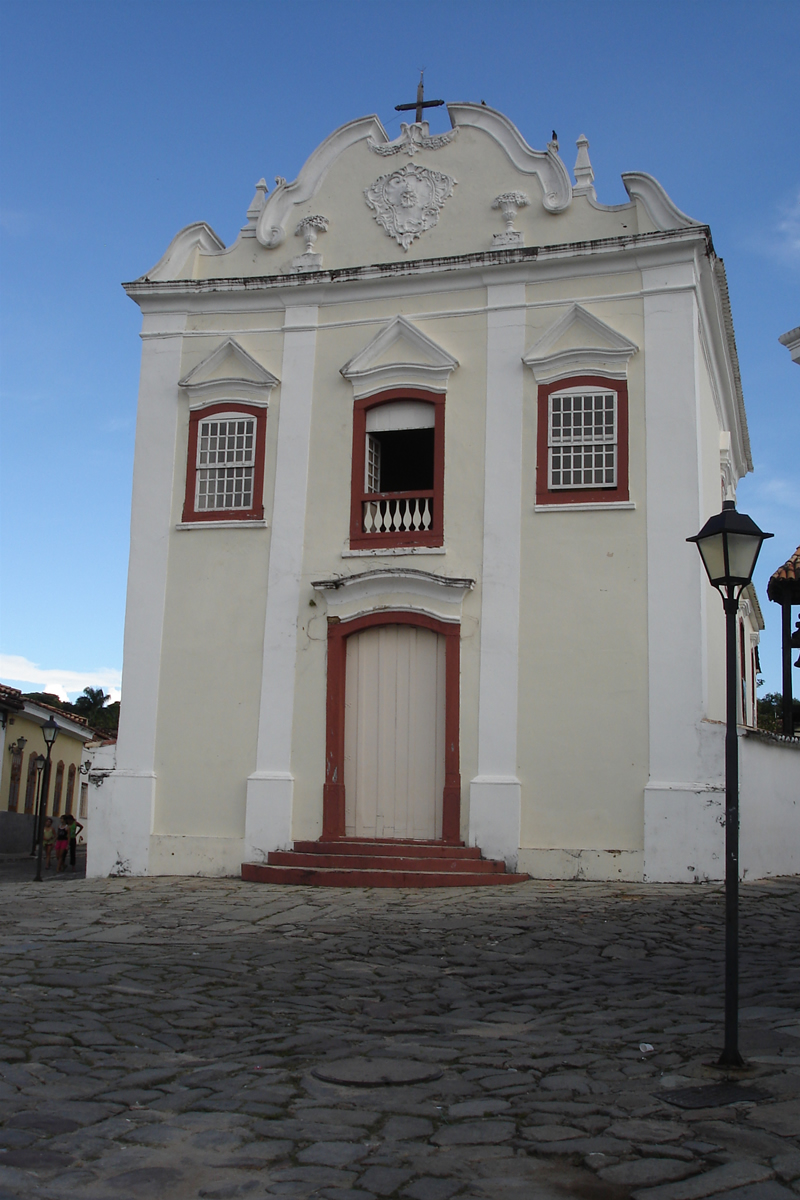
Historic Centre of the Town of Goiás
Brazil · 15.9333° S, 50.1334° W · 36 km from Itaberaí
Goiás testifies to the occupation and colonization of the lands of central Brazil in the 18th and 19th centuries. The urban layout is an example of the organic development of a mining town, adapted to the conditions of the site. Although modest, both public and private architecture form a harmonious whole, thanks to the coherent use of local materials and vernacular techniques.
Description from the UNESCO World Heritage Centre (CC BY-SA IGO 3.0).
Why Historic Centre of the Town of Goiás Is Listed
- (ii)
- An important interchange of human values.
- (iv)
- An outstanding example of a type of building or landscape.

Tijuca Forest
Brazil · 22.9630° S, 43.2450° W · 72 km² · 5 km from Rio de Janeiro
The Tijuca National Park (Portuguese: Parque Nacional da Tijuca) is an urban national park in the mountains of the city of Rio de Janeiro, Brazil. The park is part of the Atlantic Forest Biosphere Preserve, and is administered by the Chico Mendes Institute for Biodiversity Conservation (ICMBio).
The area is composed of secondary vegetation, as it is the result of reforestation carried out during the Second Empire, when it became clear that deforestation caused by coffee farms was harming the drinking water supply of the then-capital of the Empire. More than 230 species of animals and birds live in the park, including capuchin monkeys, coatis, agoutis, wild dogs, marmosets, hummingbirds and thrushes.
Adapted from Wikipedia: Tijuca National Park (CC BY-SA 4.0).
Why Tijuca Forest Is Listed
- (v)
- An outstanding example of traditional human settlement or land use.
- (vi)
- A direct association with events, ideas or beliefs of universal significance.
More about Tijuca Forest
UNESCO's Description
The site consists of an exceptional urban setting encompassing the key natural elements that have shaped and inspired the development of the city: from the highest points of the Tijuca National Park’s mountains down to the sea. They also include the Botanical Gardens, established in 1808, Corcovado Mountain with its celebrated statue of Christ, and the hills around Guanabara Bay, including the extensive designed landscapes along Copacabana Bay which have contributed to the outdoor living culture of this spectacular city. Rio de Janeiro is also recognized for the artistic inspiration it has provided to musicians, landscapers and urbanists.
From the UNESCO World Heritage Centre (CC BY-SA IGO 3.0).
Geography
Tijuca National Park is claimed to be the world's largest urban forest, covering some 39.58 square kilometres (15.28 mi2), although this title is disputed with Johannesburg, South Africa.
The park shares its name with the bairros (neighborhoods) of Tijuca and Barra da Tijuca nearby. The word Tijuca comes from the Tupi language and means marsh, a reference to the Tijuca Lagoon in the contemporary Barra da Tijuca.
It is located in a mountainous region which encompasses the Tijuca Massif. Among its impressive peaks are the Pedra da Gávea, Corcovado and Pico da Tijuca. The forest and mountains form a natural boundary that separates the West Zone of Rio from the rest of the city, as well as dividing the North and South Zones.
One favela exists in the Tijuca Forest, called Mata Machado.
History
The contemporary Tijuca National Park and its surrounding forests are largely the result of reforestation. In the 1700s, forests in the future park around Rio de Janeiro were cleared for fuel, coffee growing, and livestock. The small streams in the former forest were a significant source of the city's water supply, and, with variable rainfall, the city began to experience water shortages and flash floods.
Early conservation efforts began in 1817, when King Dom João VI issued a decree prohibiting the cutting of trees surrounding the springs of the Carioca River to protect the city's water supply.
Tourism
Given its proximity to the city, the park receives heavy use: in 2016, the park received 3,305,010 visitors. The park contains a number of attractions, most famously the colossal sculpture of Christ the Redeemer. Other attractions include the Cascatinha Waterfall; the Mayrink Chapel, with murals painted by Cândido Portinari; the pagoda-style gazebo at Vista Chinesa; and a giant granite table called the Mesa do Imperador ("Emperor's Table").
There are numerous hiking trails. Common destinations are: Diamantina's waterfall, Parrot's Beak (Bico do Papagaio), Tijuca's Peak (Pico da Tijuca), Cave Circuit (Circuito das Grutas), Archer's Hill (Morro do Archer), Anhanguera's Hill (Morro da Anhanguera), the Excelsior Lookout (Mirante do Excelsior) and the Bat's Cave (Caverna dos Morcegos).
Sections adapted from Wikipedia: Tijuca National Park (CC BY-SA 4.0).
Key Facts
| Established | 1961 |
|---|---|
| Area | 39.6 km² |
Facts from Wikidata Q1974494 (CC0).
Visiting Tijuca Forest
Tijuca National Park (Parque Nacional da Tijuca in Portuguese) is a protected natural area in and surrounding Rio de Janeiro, Brazil. It is the world's largest urban forest, whose dense woodlands blanket many of Rio's scenic mountain peaks, including iconic landmarks like Corcovado, the mountain capped by Rio's famous Christ the Redeemer statue. The park comprises four distinct, non-contiguous sectors and park access points are in many districts of the city. The park has more than 200 km of wooded hiking trails, 30 waterfalls, dozens of scenic overlooks with views of the city and ocean, and several peaks used for mountain climbing, rapelling, and launching hang gliders and paragliders.
Travel notes adapted from Wikivoyage: Tijuca National Park (CC BY-SA 4.0).

Valongo Wharf
Brazil · 22.8971° S, 43.1874° W · 5 km from Rio de Janeiro
The Valongo Wharf (Portuguese: Cais do Valongo) is an old dock located in the port area of Rio de Janeiro, between the current Coelho e Castro and Sacadura Cabral streets. Built in 1811, it was the site of landing and trading of enslaved Africans until 1831, with the blockade of Africa banning the Atlantic slave trade to Brazil (but the Brazilian government continued turning a blind eye to the trade until 1850).
During the twenty years of its operation, between 500 thousand and one million slaves landed at Valongo. Brazil received about 4.9 million slaves through the Atlantic trade.
In 1843, the wharf was renovated for the landing of Princess Teresa Cristina of Bourbon-Two Sicilies, who was to marry the emperor D. Pedro II. The wharf was then called Cais da Imperatriz (Empress Wharf).
Between 1850 and 1920, the area around the old pier became a space occupied by black slaves or freedmen of several nations - an area that Heitor dos Prazeres called Pequena África (Little Africa).
Adapted from Wikipedia: Valongo Wharf (CC BY-SA 4.0).
Why Valongo Wharf Is Listed
- (vi)
- A direct association with events, ideas or beliefs of universal significance.
More about Valongo Wharf
UNESCO's Description
Valongo Wharf Archaeological Site is located in central Rio de Janeiro and encompasses the entirety of Jornal do Comércio Square. It is in the former harbour area of Rio de Janeiro in which the old stone wharf was built for the landing of enslaved Africans reaching the South American continent from 1811 onwards. An estimated 900,000 Africans arrived in South America via Valongo. The site is composed of several archaeological layers, the lowest of which consists of floor pavings in pé de moleque style, attributed to the original Valongo Wharf. It is the most important physical trace of the arrival of African slaves on the American continent.
From the UNESCO World Heritage Centre (CC BY-SA IGO 3.0).
History
Until the mid-1770s, slaves disembarked at Praia do Peixe, now called Praça 15, and were traded in Rua Direita (today Rua 1º de Março), in the center of Rio de Janeiro, in plain sight. In 1774, a new legislation established the transfer of this market to the region of Valongo, on the initiative of the second Marquis of Lavradio, Dom Luís de Almeida Portugal Soares de Alarcão d'Eça e Melo Silva Mascarenhas, viceroy of Brazil, alarmed at "The terrible custom of as soon as the blacks disembark in the port from the African coast, enter the city through the main public thoroughfares, not only loaded with innumerable diseases but naked".
Sections adapted from Wikipedia: Valongo Wharf (CC BY-SA 4.0).
Sítio Roberto Burle Marx
Brazil · 23.0238° S, 43.5447° W · 32 km from Nova Iguaçu
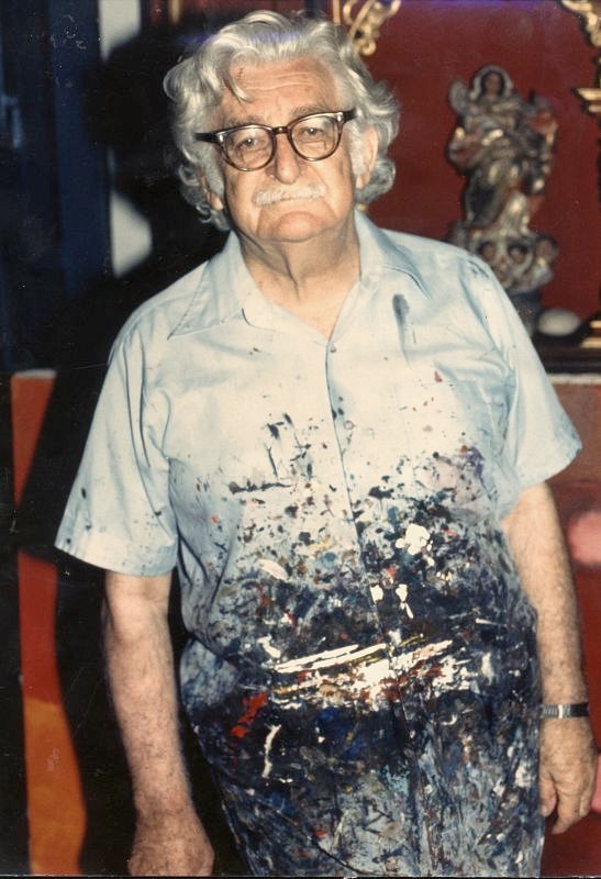
Roberto Burle Marx (August 4, 1909 – June 4, 1994) was a Brazilian landscape architect (as well as a painter, print maker, ecologist, naturalist, artist and musician) whose designs of parks and gardens made him world-famous. He is credited with having introduced modernist landscape architecture to Brazil. He was known as a modern nature artist and a public urban space designer. His work had a great influence on tropical garden design in the 20th century. Water gardens were a popular theme in his work. He was deftly able to transfer traditional artistic expressions such as graphic design, tapestry and folk art into his landscape designs. He also designed fabrics, jewellery and stage sets.
He was one of the first people to call for the conservation of Brazil's rainforests. More than 50 plants bear his name. He amassed a substantial collection of plants at his home, including more than 500 philodendrons, including some that were discovered by him or bear his name, like Philodendron burle-marxii.
Adapted from Wikipedia: Roberto Burle Marx (CC BY-SA 4.0).
Why Sítio Roberto Burle Marx Is Listed
- (ii)
- An important interchange of human values.
- (iv)
- An outstanding example of a type of building or landscape.
More about Sítio Roberto Burle Marx
UNESCO's Description
Situated in the western region of Rio de Janeiro, the property embodies a successful project developed over more than 40 years by landscape architect and artist Roberto Burle Marx (1909-1994), a “landscape laboratory” to create “living works of art” using native plants and drawing on Modernist ideas. Began in 1949, the property encompasses extensive landscapes, gardens, buildings and collections, which feature the key characteristics that came to define Burle Marx’s landscape gardens and influenced the development of modern gardens internationally. The site is characterized by sinuous forms, exuberant mass planting, architectural plant arrangements, dramatic colour contrasts, use of tropical plants, and the incorporation of elements of traditional folk culture. By the end of the 1960s, the site housed the most representative collection of Brazilian plants, alongside other rare tropical species. In the site, 3,500 cultivated species of tropical and subtropical flora grow in harmony with the native vegetation of the region, notably the Atlantic Forest biome and associated ecosystems, mangrove swamp and restinga (coastal tropical sandy plain). Sítio Roberto Burle Marx exhibits an ecological conception of form as a process, including social collaboration which is the basis for environmental and cultural preservation. It comprises the first modern tropical garden to be inscribed on the World Heritage List.
From the UNESCO World Heritage Centre (CC BY-SA IGO 3.0).

Lençóis Maranhenses National Park
Brazil · 2.4833° S, 43.1333° W · 1,566 km² · 104 km from São José de Ribamar
Lençóis Maranhenses National Park (, Parque Nacional dos Lençóis Maranhenses) is a national park in Maranhão state in northeastern Brazil, just east of the Baía de São José. Protected on June 2, 1981, the 155,000 ha (380,000-acre) park includes 70 km (43 mi) of coastline, and an interior composed of rolling sand dunes. During the rainy season, the valleys among the dunes fill with freshwater lagoons, prevented from draining by the impermeable rock beneath. The park is home to a range of species, including four listed as endangered, and has become a popular destination for ecotourists.
In July 2024, the site was declared a UNESCO World Heritage Site for its exceptional beauty and the fact that it is a unique natural aspect in the world.
Adapted from Wikipedia: Lençóis Maranhenses National Park (CC BY-SA 4.0).
Why Lençóis Maranhenses National Park Is Listed
- (vii)
- Superlative natural phenomena or exceptional natural beauty.
- (viii)
- An outstanding example of major stages of the Earth's history.
- (x)
- The most important natural habitats for conserving biodiversity.
More about Lençóis Maranhenses National Park
UNESCO's Description
The property is located in northeastern Brazil, on the east coast of Maranhão, in a transition zone between three Brazilian biomes: Cerrado, Caatinga and Amazon. More than half of its area consists of a white coastal dune field with temporary and permanent lagoons. Beyond its important role in biodiversity conservation, the park boasts globally significant aesthetic and geological/geomorphological values. Along an 80 km coastline, with beaches followed by plains, the prevailing winds shape the dunes into long chains of barchans, filled in the rainy season to create lagoons of various colours, shapes, sizes and depths. The property reveals its best scenery when the lagoons reach their maximum volume, creating rare beauty. The vast expanse of both stable and shifting dunes, the largest in South America, presents remarkable evidence of the evolutionary progression of coastal dunes throughout the Quaternary period.
From the UNESCO World Heritage Centre (CC BY-SA IGO 3.0).
Physical geography
The park is located on the northeastern coast of Brazil in the state of Maranhão along the eastern coast, bordered by 70 kilometres (43 mi) of beaches along the Atlantic Ocean. Inland, it is bordered by the Parnaíba River, the São José Basin, and the rivers of Itapecuru, Munim, and Periá. The park encompasses an area of 155,000 hectares (380,000 acres), composed mainly of expansive coastal dune fields (composed of barchanoid dunes), which formed during the late Quaternary period.
While much of the park has the appearance of a desert, the area receives about 1,200 millimetres (47 in) of rain per year, while deserts, by definition, receive less than 250 millimetres (10 in) annually. About 70% of this rainfall occurs between the months of January and May.
Ecology
The lagoons in the park are often interconnected with one another, as well as with the rivers that run through the area. They are home to a number of fish and insect species, including the wolf fish, which burrows down into wet layers of mud and remains dormant during the dry season. Besides the dunes that form the centerpiece of the park, the ecosystem also includes area of restinga and mangrove ecosystems.
The park is home to four species listed on the Brazilian List of Endangered Species: the scarlet ibis (Eudocimus ruber), the neotropical otter (Lontra longicaudis), the oncilla (Leopardus tigrinus) and the West Indian manatee (Trichechus manatus). The park also includes 133 species of plants, 112 species of birds, and at least 42 species of reptiles.
Sections adapted from Wikipedia: Lençóis Maranhenses National Park (CC BY-SA 4.0).
Key Facts
| Established | 2 June 1981 |
|---|---|
| Area | 1,566 km² |
Facts from Wikidata Q647777 (CC0).

Cavernas do Peruaçu Environmental Protection Area
Brazil · 14.9000° S, 44.0500° W · 380 km² · 73 km from Januária
Cavernas do Peruaçu Environmental Protection Area (Portuguese: Área de Proteção Ambiental Cavernas do Peruaçu) is a protected area in the state of Minas Gerais, Brazil.
Adapted from Wikipedia: Cavernas do Peruaçu Environmental Protection Area (CC BY-SA 4.0).
Why Cavernas do Peruaçu Environmental Protection Area Is Listed
- (vii)
- Superlative natural phenomena or exceptional natural beauty.
- (viii)
- An outstanding example of major stages of the Earth's history.
More about Cavernas do Peruaçu Environmental Protection Area
UNESCO's Description
Located in northern Minas Gerais and featuring dramatic karst landscapes, vast caves, and rich biodiversity, the park’s horizontal cave systems, formed in carbonate rock, reveal striking speleothems, collapsed dolines, limestone arches, and underground rivers. Developed in the stable São Francisco craton, the landscape reflects major climatic and geological changes from the Plio-Pleistocene. The park lies at the intersection of the Cerrado, Caatinga, and Atlantic Forest biomes, supporting over 2,000 plant and animal species, including many threatened ones.
From the UNESCO World Heritage Centre (CC BY-SA IGO 3.0).
Location
The Cavernas do Peruaçu Environmental Protection Area, which covers 143,354 hectares (354,240 acres) of Cerrado biome, was established on 26 September 1989. The area is administered by the Chico Mendes Institute for Biodiversity Conservation. It covers parts of the municipalities of Bonito de Minas, Cônego Marinho, Itacarambi and Januária in the state of Minas Gerais.
Sections adapted from Wikipedia: Cavernas do Peruaçu Environmental Protection Area (CC BY-SA 4.0).
Key Facts
| Established | 1989 |
|---|---|
| Area | 1,434 km² |
Facts from Wikidata Q5055056 (CC0).

Cavernas do Peruaçu National Park
Brazil · 15.1225° S, 44.3243° W · 3,814 km² · 40 km from Januária
Cavernas do Peruaçu National Park (Portuguese: Parque Nacional Cavernas do Peruaçu) is a national park in the state of Minas Gerais, Brazil.
It is noted for its large limestone caves.
Adapted from Wikipedia: Cavernas do Peruaçu National Park (CC BY-SA 4.0).
Why Cavernas do Peruaçu National Park Is Listed
- (ix)
- An outstanding example of ongoing ecological and biological processes.
- (x)
- The most important natural habitats for conserving biodiversity.
More about Cavernas do Peruaçu National Park
UNESCO's Description
The two sites included in the designation contain flora and fauna and key habitats that characterize the Cerrado – one of the world’s oldest and most diverse tropical ecosystems. For millennia, these sites have served as refuge for several species during periods of climate change and will be vital for maintaining the biodiversity of the Cerrado region during future climate fluctuations.
From the UNESCO World Heritage Centre (CC BY-SA IGO 3.0).
Location
The Cavernas do Peruaçu National Park, with an area of 56,448 hectares (139,490 acres), was created on 21 September 1999 and is administered by the Chico Mendes Institute for Biodiversity Conservation.
The park covers parts of the municipalities of Januária, Itacarambi and São João das Missões in the north of the state of Minas Gerais.
Nearby are the Veredas do Peruaçu State Park, operated by the State Forestry Institute, and the Xakriabá Indian Reserve.
The Peruaçu River crosses the park from north west to south east, entering the São Francisco River, which runs along the south east boundary of the park.
The Cavernas do Peruaçu Environmental Protection Area (EPA), with an area of 143,866 hectares (355,500 acres), was created on 26 September 1989.
Sections adapted from Wikipedia: Cavernas do Peruaçu National Park (CC BY-SA 4.0).
Key Facts
| Established | 1999 |
|---|---|
| Area | 564 km² |
Facts from Wikidata Q1051873 (CC0).
Amazonia Theaters
Brazil · 1.4530° S, 48.4937° W · 1 km from Belém
The property consists of two component parts: The Theatro da Paz and the Praça da República in Belém, and the Teatro Amazonas and the Largo de São Sebastião in Manaus. These were built in the States of Pará and Amazonas in Brazil during the Amazonian ‘Golden Age’ as a result of the economic peak of the Rubber Cycle between 1879 and 1912. Inspired by French and European architecture and decorated with motifs evoking the Amazon, these ensembles were designed as symbols of political and urban ambition. Inaugurated in 1878 and 1889, the Theatro da Paz and the Praça da República asserted the strategic role of the city of Belém as a port and State capital and celebrated the Brazilian Republic, while the Teatro Amazonas, inaugurated in 1896, was part of the large-scale urban development of Manaus during the rubber boom and, along with the Largo de São Sebastião, expressed the wealth and prestige of the future capital of the Amazon.
Description from the UNESCO World Heritage Centre (CC BY-SA IGO 3.0).
Why Amazonia Theaters Is Listed
- (ii)
- An important interchange of human values.
- (iv)
- An outstanding example of a type of building or landscape.
- (vi)
- A direct association with events, ideas or beliefs of universal significance.
Shared With Neighbouring Countries
These sites cross the border. Each is written up on the page of the country UNESCO lists first.

World Heritage in Brazil: Quick Answers
- How many UNESCO World Heritage Sites are in Brazil?
- Brazil has 22 World Heritage Sites: 15 cultural and 7 natural. 1 of them is shared with a neighbouring country.
- What was the first World Heritage Site in Brazil?
- Historic Town of Ouro Preto, inscribed in 1980. The most recent is Amazonia Theaters, inscribed in 2026.
- What are the natural World Heritage Sites in Brazil?
- Iguaçu National Park, Atlantic Forest South-East Reserves, Central Amazon Conservation Complex, Pantanal, Lençóis Maranhenses National Park, Cavernas do Peruaçu Environmental Protection Area, Cavernas do Peruaçu National Park.
- Are any World Heritage Sites in Brazil in danger?
- None of the World Heritage Sites in Brazil is on UNESCO's List of World Heritage in Danger.