
UNESCO World Heritage Sites in Argentina
Argentina has 11 sites on the UNESCO World Heritage List (6 cultural and 5 natural), the first inscribed in 1981 (Los Glaciares National Park). The map below plots every one of them alongside the rest of the List, and each site is written up in full further down the page.
- World Heritage Sites
- 11
- Cultural
- 6
- Natural and Mixed
- 5
- First Inscribed
- 1981
Map of World Heritage Sites in Argentina
CulturalNaturalMixedIn DangerLarge dots are in Argentina. Click a dot to read about the site.

Los Glaciares National Park
Argentina · 50.3305° S, 73.2342° W · 7,269 km²
Los Glaciares National Park (Spanish: Parque Nacional Los Glaciares) is a federal protected area in Santa Cruz Province, Argentina.
The park covers an area of 726,927 ha (7,269.27 km2; 2,806.68 sq mi), making it the largest national park in the country.
Established on 11 May 1937, it hosts a representative sample of Magellanic subpolar forest and west Patagonian steppe biodiversity in a good state of conservation. In 1981, it was declared a World Heritage Site by UNESCO.
The park's name refers to the giant ice cap in the Andes, the largest outside of Antarctica, Greenland and Iceland, feeding 47 large glaciers, of which 13 flow towards the Pacific Ocean. In other parts of the world, glaciers start at a height of at least 2,500 m (8,200 ft) above mean sea level, but due to the size of the ice cap, these glaciers begin at only 1,500 m (4,900 ft), sliding down to 200 m (660 ft). Los Glaciares borders Torres del Paine National Park to the south in Chilean territory.
Adapted from Wikipedia: Los Glaciares National Park (CC BY-SA 4.0).
Why Los Glaciares National Park Is Listed
- (vii)
- Superlative natural phenomena or exceptional natural beauty.
- (viii)
- An outstanding example of major stages of the Earth's history.
More about Los Glaciares National Park
UNESCO's Description
The Los Glaciares National Park is an area of exceptional natural beauty, with rugged, towering mountains and numerous glacial lakes, including Lake Argentino, which is 160 km long. At its farthest end, three glaciers meet to dump their effluvia into the milky grey glacial water, launching massive igloo icebergs into the lake with thunderous splashes.
From the UNESCO World Heritage Centre (CC BY-SA IGO 3.0).
Geography
Los Glaciares, of which 30% is covered by ice, can be divided into two parts, each corresponding to one of the two elongated big lakes partially contained by the park. Lake Argentino, 1,466 km2 (566 sq mi) and the largest in Argentina, is in the south, while Lake Viedma, 1,100 km2 (420 sq mi), is in the north. Both lakes feed the Santa Cruz River that flows down to Puerto Santa Cruz on the Atlantic. Between the two halves is a non-touristic zone without lakes called Zona Centro.
The northern half consists of part of Viedma Lake, the Viedma Glacier and a few minor glaciers, and a number of mountains very popular among fans of climbing and trekking, including Mount Fitz Roy and Cerro Torre.
Climate
The park has a cool and moist temperate climate. Mean temperatures range from 0.6 °C (33.1 °F) in winter to 13.4 °C (56.1 °F) in summer although at higher altitudes, the mean annual temperature can be around −3 °C (26.6 °F). The park receives an average annual rainfall of 500 mm (20 in) in the west and 900 mm (35 in) in the east which is evenly distributed throughout the year. Snowfall is common during the colder months.
Ecology
The mountains hold most of the humidity from the Pacific Ocean, letting through only the ice coldness (annual average of 7.5 °C (45.5 °F)) and creating the arid Patagonian steppe on the Argentine side of the range. This area is habitat for rheas, guanaco, cougar, and South American gray fox, the latter of which has suffered from the invasion of the cattle industry and are endangered. The guanaco, while not endangered, has had a dramatic decline in historic population due to large scale grazing of livestock throughout much of Patagonia. There are over 100 species of birds in the area (condors, eagles, and others). Between the ice and the Patagonian steppe there is a fertile area of Magellanic subpolar forests composed mainly of lengas and guindos, but also ñires.
Sections adapted from Wikipedia: Los Glaciares National Park (CC BY-SA 4.0).
Key Facts
| Established | 11 May 1937 |
|---|---|
| Area | 4,459 km² |
Facts from Wikidata Q215992 (CC0).
Visiting Los Glaciares National Park
Los Glaciares National Park is the second largest national park in Argentina and a UNESCO World Heritage site. This area of over 4000 km² in Argentine Patagonia is complete with mountains, glaciers, lakes, wildlife and arctic views. The giant ice cap in Los Glaciares National Park feeds over 40 glaciers, the largest outside of Antarctica and Greenland. One third of the park is covered by ice that can tower up to 1500 m in the air.
Travel notes adapted from Wikivoyage: Los Glaciares National Park (CC BY-SA 4.0).

Jesuit missions among the Guaraní
Argentina, Brazil · 27.2553° S, 55.5317° W · 3 km² · 35 km from Encarnación
The Jesuit missions among the Guaraní were a type of settlement for the Guaraní people ("Indians" or "Indios") in an area straddling the borders of present-day Argentina, Brazil and Paraguay, known locally as the triple frontier. The missions were established by the Jesuit Order of the Catholic Church early in the 17th century and ended in the late 18th century after the expulsion of the order from the Americas. The missions have been called an experiment in "socialist theocracy" or a rare example of "benign colonialism". Others have said that "the Jesuits took away the Indians' freedom, forced them to radically change their lifestyle, physically abused them, and subjected them to disease".
In their newly acquired South American dominions, the Spanish and Portuguese Empires adopted a strategy of gathering native populations into communities called "Indian reductions" (Spanish: reducciones de indios, Portuguese: reduções). The objectives of the reductions were to impart Christianity and European culture. Secular as well as religious authorities created "reductions".
The missions among the Guaraní are often called collectively the Río de la Plata missions.
Adapted from Wikipedia: Jesuit missions among the Guaraní (CC BY-SA 4.0).
Why Jesuit missions among the Guaraní Is Listed
- (iv)
- An outstanding example of a type of building or landscape.
More about Jesuit missions among the Guaraní
UNESCO's Description
The ruins of São Miguel das Missões in Brazil, and those of San Ignacio Miní, Santa Ana, Nuestra Señora de Loreto and Santa María la Mayor in Argentina, lie at the heart of a tropical forest. They are the impressive remains of five Jesuit missions, built in the land of the Guaranis during the 17th and 18th centuries. Each is characterized by a specific layout and a different state of conservation.
From the UNESCO World Heritage Centre (CC BY-SA IGO 3.0).
History
In the 16th century, priests of different religious orders set out to evangelize the Americas, bringing Christianity to indigenous communities. The colonial governments and missionaries agreed on the strategy of gathering the often nomadic indigenous populations in larger communities called reductions in order to more effectively govern, tax, and evangelize them. Reductions generally were also construed as an instrument to make the Indians adopt European lifestyles and values. In Mexico the policy was called congregación, and also took the form of the hospitals of Vasco de Quiroga and the Franciscan Missions of California. In Portuguese Brazil reductions were known as aldeias.
Sections adapted from Wikipedia: Jesuit missions among the Guaraní (CC BY-SA 4.0).
Key Facts
| Established | 29 December 1609 |
|---|
Facts from Wikidata Q465960 (CC0).

Iguazú National Park World Heritage Site
Argentina · 25.6667° S, 54.4000° W · 550 km² · 21 km from Foz do Iguaçu
The semicircular waterfall at the heart of this site is some 80 m high and 2,700 m in diameter and is situated on a basaltic line spanning the border between Argentina and Brazil. Made up of many cascades producing vast sprays of water, it is one of the most spectacular waterfalls in the world. The surrounding subtropical rainforest has over 2,000 species of vascular plants and is home to the typical wildlife of the region: tapirs, giant anteaters, howler monkeys, ocelots, jaguars and caymans.
Description from the UNESCO World Heritage Centre (CC BY-SA IGO 3.0).
Why Iguazú National Park World Heritage Site Is Listed
- (vii)
- Superlative natural phenomena or exceptional natural beauty.
- (x)
- The most important natural habitats for conserving biodiversity.

Cueva de las Manos
Argentina · 47.1500° S, 70.6667° W · 6 km²
Cueva de las Manos (Spanish for Cave of the Hands or Cave of Hands) is a cave and complex of rock art sites in the province of Santa Cruz, Argentina, 163 km (101 mi) south of the town of Perito Moreno. It is named for the hundreds of paintings of hands stenciled, in multiple collages, on the rock walls. The art was created in several waves between 7,300 BC and AD 700, during the Archaic period of pre-Columbian South America. The age of the paintings was calculated from the remains of bone pipes used for spraying the paint on the wall of the cave to create the artwork, radiocarbon dating of the artwork, and stratigraphic dating.
The site is considered by some scholars to be the best material evidence of early South American hunter-gatherer groups. Argentine surveyor and archaeologist Carlos J. Gradin and his team conducted the most important research on the site in 1964, when they began excavating sites during a 30-year study of cave art in and around Cueva de las Manos. The site is a National Historic Monument in Argentina and a UNESCO World Heritage Site.
Adapted from Wikipedia: Cueva de las Manos (CC BY-SA 4.0).
Why Cueva de las Manos Is Listed
- (iii)
- A unique testimony to a cultural tradition or civilisation.
More about Cueva de las Manos
UNESCO's Description
The Cueva de las Manos, Río Pinturas, contains an exceptional assemblage of cave art, executed between 13,000 and 9,500 years ago. It takes its name (Cave of the Hands) from the stencilled outlines of human hands in the cave, but there are also many depictions of animals, such as guanacos ( Lama guanicoe ), still commonly found in the region, as well as hunting scenes. The people responsible for the paintings may have been the ancestors of the historic hunter-gatherer communities of Patagonia found by European settlers in the 19th century.
From the UNESCO World Heritage Centre (CC BY-SA IGO 3.0).
Geology
The cave is in the walls of the canyon, which are composed of ignimbrite and other volcanic rocks in the Bahía Laura Group. The rocks were formed about 150 million years ago during the Jurassic period as part of the larger Deseado Massif. The cave and surrounding overhangs were carved out of the rock face through differential erosion, a process by which weaker rocks are eroded away, leaving formations composed of the stronger rocks. This erosion was caused by the Pinturas River, fed by glacial runoff, which cut into the Chon Aike Formation to form the Pinturas Canyon. The cave itself is located at a fissure in the rock face that the river eroded more than the surrounding canyon wall.
History
When the site was occupied, the Pinturas and Deseado Rivers drained into the Atlantic Ocean and provided water for herds of guanacos, making the area attractive to Paleoindians. As the glacial ice fields melted, the Baker River captured the drainage of the eastward flowing rivers. The resulting reduction in water levels of the Pinturas and Deseado rivers led to a progressive abandonment of the Cueva de las Manos site.
Projectile points, a bola stone fragment, side-scrapers, and fire pits have been found alongside the remains of guanaco, puma, fox, birds, and other small animals. Guanacos were the natives' primary food source; hunting methods included bolas, ambushes, and game drives, in which they would drive guanacos into ravines and other confined areas to better collectively hunt them.
Location
Cueva de las Manos refers to both the main site of the cave and the surrounding complex of rock art sites that includes it. The cave lies at the base of a stepped cliff in the Pinturas River Canyon, in the upper part of the Deseado River basin, in an isolated part of Patagonia. It is about 165 km (103 mi) south of Perito Moreno, a town in northwest Santa Cruz Province, Argentina. It is part of both Perito Moreno National Park and Cueva de las Manos Provincial Park.
During the time of the Paleoindians, around the late Pleistocene to early Holocene geological periods, the areas between 400 and 500 meters (1,300 and 1,600 ft) above sea level formed a microclimate in the canyon promoting a grassland ecosystem hospitable to many animals.
Sections adapted from Wikipedia: Cueva de las Manos (CC BY-SA 4.0).
Key Facts
| Established | 7350s BCE |
|---|---|
| Area | 6 km² |
Facts from Wikidata Q223385 (CC0).
Visiting Cueva de las Manos
Cueva de las Manos, Spanish for cave of the hands, is a natural and cultural monument in Patagonia, of southwest Argentina, in the province of Santa Cruz. It has been a UNESCO World Heritage Site since 1999 and contains the most famous cave paintings of southern South America.
Travel notes adapted from Wikivoyage: Cueva de las Manos (CC BY-SA 4.0).

Valdes Peninsula
Argentina · 42.5000° S, 63.9333° W · 8,261 km² · 95 km from Puerto Madryn
The Valdés Peninsula (Spanish: Península Valdés) is a peninsula into the Atlantic Ocean in the Viedma Department of northeast Chubut Province, Argentina. It is bordered by San Matías Gulf to the north. It is an important nature reserve which was listed as a World Heritage Site by UNESCO in 1999.
Adapted from Wikipedia: Valdés Peninsula (CC BY-SA 4.0).
Why Valdes Peninsula Is Listed
- (x)
- The most important natural habitats for conserving biodiversity.
More about Valdes Peninsula
UNESCO's Description
Península Valdés in Patagonia is a site of global significance for the conservation of marine mammals. It is home to an important breeding population of the endangered southern right whale as well as important breeding populations of southern elephant seals and southern sea lions. The orcas in this area have developed a unique hunting strategy to adapt to local coastal conditions.
From the UNESCO World Heritage Centre (CC BY-SA IGO 3.0).
Geography
The peninsula is about 3,625 km2 (1,400 sq mi) in size (not taking into account the isthmus of Carlos Ameghino which connects the peninsula to the mainland). The nearest large town is Puerto Madryn. The only town on the peninsula is the small settlement of Puerto Pirámides. There are also a number of estancias, where sheep are raised.
Most of the peninsula is barren land with some salt lakes. The largest of these lakes has an elevation of about 40 m below sea level (see extremes on Earth), until recently thought to be the lowest elevation in Argentina and South America (the lowest point actually being Laguna del Carbón, Argentina, which is also the lowest point in all of South America).
The coastline is inhabited by marine mammals, such as sea lions, elephant seals and fur seals.
Sections adapted from Wikipedia: Valdés Peninsula (CC BY-SA 4.0).

Ischigualasto / Talampaya Natural Parks
Argentina · 29.8000° S, 67.8333° W · 2,754 km² · 78 km from Chilecito
These two contiguous parks, extending over 275,300 ha in the desert region on the western border of the Sierra Pampeanas of central Argentina, contain the most complete continental fossil record known from the Triassic Period (245-208 million years ago). Six geological formations in the parks contain fossils of a wide range of ancestors of mammals, dinosaurs and plants revealing the evolution of vertebrates and the nature of palaeo-environments in the Triassic Period.
Description from the UNESCO World Heritage Centre (CC BY-SA IGO 3.0).
Why Ischigualasto / Talampaya Natural Parks Is Listed
- (viii)
- An outstanding example of major stages of the Earth's history.

Jesuit Block and Estancias of Córdoba
Argentina · 31.6561° S, 64.4353° W · 1 km from Alta Gracia
The Jesuit Block and Estancias of Córdoba (Spanish: Manzana Jesuítica y Estancias de Córdoba) are a collection of buildings and sites formerly used by the Jesuits in the province of Córdoba, Argentina, which were named a World Heritage Site in 2000.
Adapted from Wikipedia: Jesuit Block and Estancias of Córdoba (CC BY-SA 4.0).
Why Jesuit Block and Estancias of Córdoba Is Listed
- (ii)
- An important interchange of human values.
- (iv)
- An outstanding example of a type of building or landscape.
More about Jesuit Block and Estancias of Córdoba
UNESCO's Description
The Jesuit Block in Córdoba, heart of the former Jesuit Province of Paraguay, contains the core buildings of the Jesuit system: the university, the church and residence of the Society of Jesus, and the college. Along with the five estancias, or farming estates, they contain religious and secular buildings, which illustrate the unique religious, social, and economic experiment carried out in the world for a period of over 150 years in the 17th and 18th centuries.
From the UNESCO World Heritage Centre (CC BY-SA IGO 3.0).
History
After the founding of the university, the different estancias were started between 1616 (La Caroya) and 1683 (La Candelaria). The estancias raised cattle, fruit and crops.
The estancias and the block had to be left by the Jesuits, following the 1767 decree by King Charles III of Spain that expelled them from the continent. They were then run by the Franciscans until 1853, when the Jesuits returned to The Americas. Nevertheless, the university and the high-school were nationalized a year later.
Sections adapted from Wikipedia: Jesuit Block and Estancias of Córdoba (CC BY-SA 4.0).
Key Facts
| Area | 0.4 km² |
|---|
Facts from Wikidata Q837642 (CC0).

Quebrada de Humahuaca
Argentina · 23.1999° S, 65.3489° W · 1,721 km² · 89 km from Libertador General San Martín
The Quebrada de Humahuaca is a narrow mountain valley located in the province of Jujuy in northwest Argentina, 1,649 km (1,025 mi) north of Buenos Aires (23°11′59″S 65°20′56″W). It is about 155 km (96 mi) long, oriented north–south, bordered by the Altiplano in the west and north, by the Sub-Andean hills in the east, and by the warm valleys (Valles Templados) in the south.
The name quebrada (literally "broken") translates as a deep valley or ravine. It receives its name from Humahuaca, a small city of 11,000 inhabitants. The Grande River (Río Grande), which is dry in winter, flows copiously through the Quebrada in the summer.
The region has always been a crossroads for economic, social and cultural communication. It has been populated for at least 10,000 years, since the settlement of the first hunter-gatherers, which is evidenced by substantial prehistoric remains. In particular, many stone-walled agricultural terraces, thought to originate more than 1500 years ago, are found throughout the region and are still in use today. The field system links a series of fortified towns called pucaras.
Adapted from Wikipedia: Quebrada de Humahuaca (CC BY-SA 4.0).
Why Quebrada de Humahuaca Is Listed
- (ii)
- An important interchange of human values.
- (iv)
- An outstanding example of a type of building or landscape.
- (v)
- An outstanding example of traditional human settlement or land use.
More about Quebrada de Humahuaca
UNESCO's Description
Quebrada de Humahuaca follows the line of a major cultural route, the Camino Inca, along the spectacular valley of the Rio Grande, from its source in the cold high desert plateau of the High Andean lands to its confluence with the Rio Leone some 150 km to the south. The valley shows substantial evidence of its use as a major trade route over the past 10,000 years. It features visible traces of prehistoric hunter-gatherer communities, of the Inca Empire (15th to 16th centuries) and of the fight for independence in the 19th and 20th centuries.
From the UNESCO World Heritage Centre (CC BY-SA IGO 3.0).

Inca road system
Argentina, Bolivia, Chile, Colombia · 18.2500° S, 69.5917° W · 36 km² · 75 km from Tacna
The Inca road system (also spelled Inka road system and in Quechua: Qhapaq Ñan meaning "royal road") was the most extensive and advanced transportation system in pre-Columbian South America. It was about 40,000 kilometres (25,000 mi) long in total. The construction of the roads required a large expenditure of time and effort.
The network was composed of formal roads carefully planned, engineered, built, marked and maintained; paved where necessary, with stairways to gain elevation, bridges and accessory constructions such as retaining walls, and water drainage systems. It was based on two north–south roads: one along the coast and the second and most important inland and up the mountains, both with numerous branches.
It can be directly compared with the road network built during the Roman Empire, although the Inca road system was built one thousand years later.
The road system allowed for the transfer of information, goods, soldiers and persons, without the use of wheels, within the Tawantinsuyu or Inca Empire throughout a territory covering almost 2,000,000 km2 (770,000 sq mi) and inhabited by about 12 million people.
Adapted from Wikipedia: Inca road system (CC BY-SA 4.0).
Why Inca road system Is Listed
- (ii)
- An important interchange of human values.
- (iii)
- A unique testimony to a cultural tradition or civilisation.
- (iv)
- An outstanding example of a type of building or landscape.
- (vi)
- A direct association with events, ideas or beliefs of universal significance.
More about Inca road system
UNESCO's Description
This site is an extensive Inca communication, trade and defence network of roads covering 30,000 km. Constructed by the Incas over several centuries and partly based on pre-Inca infrastructure, this extraordinary network through one of the world’s most extreme geographical terrains linked the snow-capped peaks of the Andes – at an altitude of more than 6,000 m – to the coast, running through hot rainforests, fertile valleys and absolute deserts. It reached its maximum expansion in the 15th century, when it spread across the length and breadth of the Andes. The Qhapac Ñan, Andean Road System includes 273 component sites spread over more than 6,000 km that were selected to highlight the social, political, architectural and engineering achievements of the network, along with its associated infrastructure for trade, accommodation and storage, as well as sites of religious significance.
From the UNESCO World Heritage Centre (CC BY-SA IGO 3.0).
History
Much of the system was the result of the Incas claiming exclusive right over numerous traditional routes, some of which had been constructed centuries earlier, mostly by the Wari empire in the central highlands of Peru and the Tiwanaku culture. This latter had developed around Lake Titicaca, in the current territories of Peru and Bolivia, between the 6th and 12th centuries CE, and had set up a complex and advanced civilization. Many new sections of the road were built or upgraded substantially by the Incas: the one through Chile's Atacama desert and the one along the western margin of Lake Titicaca serve as two examples.
The reign of the Incas originated during the Late Intermediate period (between 1000 CE and 1450 CE), when this group dominated only the region of Cusco.
Sections adapted from Wikipedia: Inca road system (CC BY-SA 4.0).
Los Alerces National Park
Argentina · 42.8075° S, 71.8989° W · 1,884 km² · 49 km from Esquel
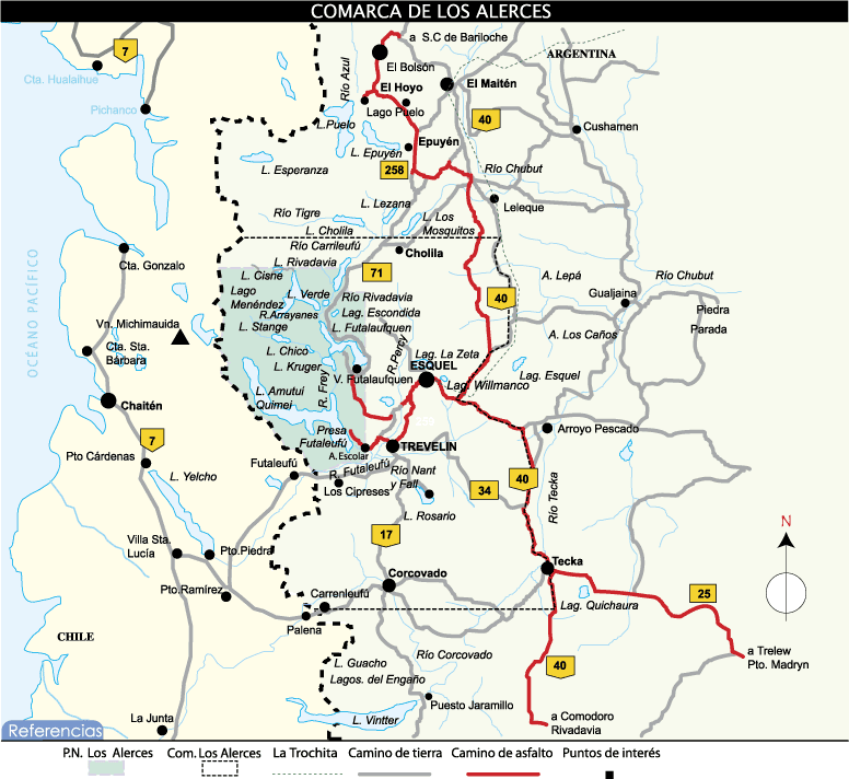
Los Alerces National Park (Spanish: Parque Nacional Los Alerces) is located in the Andes in Chubut Province in the Patagonian region of Argentina. Its western boundary coincides with the Chilean border. Successive glaciations have molded the landscape in the region creating spectacular features such as moraines, glacial cirques and clear-water lakes. The vegetation is dominated by dense temperate forests, which give way to alpine meadows higher up under the rocky Andean peaks. A highly distinctive and emblematic feature is its alerce forest; the globally threatened alerce tree is the second longest living tree species in the world (>3,600 years). The alerce forests in the park are in an excellent state of conservation. The property is vital for the protection of some of the last portions of continuous Patagonian Forest in an almost pristine state and is the habitat for a number of endemic and threatened species of flora and fauna.
Adapted from Wikipedia: Los Alerces National Park (CC BY-SA 4.0).
Why Los Alerces National Park Is Listed
- (vii)
- Superlative natural phenomena or exceptional natural beauty.
- (x)
- The most important natural habitats for conserving biodiversity.
More about Los Alerces National Park
UNESCO's Description
The Los Alerces National Park is located in the Andes of northern Patagonia and its western boundary coincides with the Chilean border. Successive glaciations have moulded the landscape in the region creating spectacular features such as moraines, glacial cirques and clear-water lakes. The vegetation is dominated by dense temperate forests, which give way to alpine meadows higher up under the rocky Andean peaks. A highly distinctive and emblematic feature is its alerce forest; the globally threatened Alerce tree is the second longest living tree species in the world (>3,600 years). The Alerce forest in the property is in an excellent state of conservation. The property is vital for the protection of some of the last portions of continuous Patagonian Forest in an almost pristine state and is the habitat for a number of endemic and threatened species of flora and fauna.
From the UNESCO World Heritage Centre (CC BY-SA IGO 3.0).
Climate
The lower elevations in Los Alerces National Park are classified as Oceanic climates, denominated Cfb, or humid continental climates, Dfb, in the Köppen climate classification system. Moisture-laden clouds from the Pacific Ocean strike the Andes on the Chilean-Argentine border and produce up to 3,000 millimetres (120 in) of precipitation annually, mostly in the form of rain at lower elevations and snow at higher elevations. Eastward from the crest of the Andes, in a rain shadow, precipitation decreases rapidly, falling to about 800 millimetres (31 in) at the eastern edge of the park. Temperatures in the park range from cold to moderate. Freezes can occur in any month of the year.
Description
Los Alerces National Park consists of two parts: the formally declared national park of 187,379 hectares (723.47 sq mi) and the adjoining Los Alerces National Reserve of 71,443 hectares (275.84 sq mi). Almost all the development in the park is in the national reserve. A buffer area 10 kilometres (6.2 mi) wide surrounds the three sides of the park which do not border on Chile.
Los Alerces National Park is shaped like a rough rectangle, extending approximately 65 kilometres (40 mi) north to south along the border with Chile and 45 kilometres (28 mi) east to west. All of Los Alerces National Park is in the drainage basin of the Futaleufú River, although the river is called by several different names during its course in Argentina.
Development and tourism
A hydroelectric dam, providing energy to industry in Puerto Madryn, has created the large Amutui Quimey Reservoir, which empties into the Futaleufú River which flows on to Chile.
There is good walking and fishing in the park, and boat trips on the lakes. The Torrecillas glacier can be seen from tour boats on Lake Menéndez.
Sections adapted from Wikipedia: Los Alerces National Park (CC BY-SA 4.0).
Key Facts
| Established | 11 May 1937 |
|---|---|
| Area | 1,884 km² |
Facts from Wikidata Q828291 (CC0).

Navy Petty-Officers School of Mechanics
Argentina · 34.5384° S, 58.4636° W · 9 km from Buenos Aires
The Higher School of Mechanics of the Navy of Argentina (Spanish: Escuela Superior de Mecánica de la Armada, commonly referred to by its acronym ESMA) is a museum in Buenos Aires. It has gone through three major transformations throughout its history. Originally ESMA served as an educational facility of the Argentine Navy. The original ESMA was a complex located at 8151 Libertador Avenue, in the barrio of Núñez. Additionally, It was the seat of U.T.3.3.2—Unidad de Tareas (Task Unit) 2 of G.T.3.3 [es].
However, ESMA later operated as an illegal, secret detention center for opponents of the 1976–1983 military dictatorship, described as "subversives" during what was described as the Dirty War. The military took the babies born to mothers imprisoned there, suppressed their true identities, and allowed military families and associates of the regime to illegally adopt them. The Unidad de Tareas (Task Unit) was responsible for thousands of instances of forced disappearance, torture, and murder during this time. ESMA was the largest detention center of its kind during the Dirty War.
Adapted from Wikipedia: Navy Petty-Officers School (CC BY-SA 4.0).
Why Navy Petty-Officers School of Mechanics Is Listed
- (vi)
- A direct association with events, ideas or beliefs of universal significance.
More about Navy Petty-Officers School of Mechanics
UNESCO's Description
This property is located within the complex of the Former Navy School of Mechanics in Buenos Aires, in the former Officers’ Quarters. This was the Argentine Navy’s principal secret detention centre during the civil-military dictatorship of 1976-1983. As part of a national strategy to destroy armed and nonviolent opposition to the military regime, the Officers' Quarters building at ESMA (Escuela Superior de Mecánica de la Armada) was used for holding captive opponents who had been abducted in Buenos Aires and interrogating, torturing and eventually killing them.
From the UNESCO World Heritage Centre (CC BY-SA IGO 3.0).
History
According to the ESSA Web site, in 1897 the Escuela de Aprendices Mecánicos de la Armada (Navy Apprentice Mechanics School) was founded in premises that are now the Historical Naval Museum of Tigre, in Buenos Aires Province. In 1900 the School moved to naval workshops in Dársena Norte; in 1902 it became Escuela de Aprendices Mecánicos y Foguistas (Apprentice Mechanics and Stokers School). Two years later it became Escuela de Mecánicos de la Armada, and in 1911 Escuela de Mecánica de la Armada. In 1928 it moved to its later notorious premises, designed by the architect Raúl J. Álvarez, on Blandengues street (now Avenida del Libertador), between Arroyo Medrano and the extension of Deheza street.
Sections adapted from Wikipedia: Navy Petty-Officers School (CC BY-SA 4.0).
World Heritage in Argentina: Quick Answers
- How many UNESCO World Heritage Sites are in Argentina?
- Argentina has 11 World Heritage Sites: 6 cultural and 5 natural.
- What was the first World Heritage Site in Argentina?
- Los Glaciares National Park, inscribed in 1981. The most recent is Navy Petty-Officers School of Mechanics, inscribed in 2023.
- What are the natural World Heritage Sites in Argentina?
- Los Glaciares National Park, Iguazú National Park World Heritage Site, Valdes Peninsula, Ischigualasto / Talampaya Natural Parks, Los Alerces National Park.
- Are any World Heritage Sites in Argentina in danger?
- None of the World Heritage Sites in Argentina is on UNESCO's List of World Heritage in Danger.