
Mesozoic Era · Triassic Period
Earth 250 Million Years Ago: Pangea, the Supercontinent
What Earth looked like 250 million years ago: a 3D globe of Pangea, the single supercontinent, just after the Great Dying wiped out about 90% of sea life.
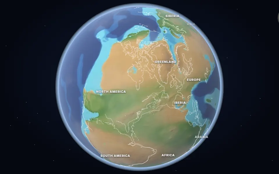 Spin it in 3D and move through time
Map: Ancient maps: PALEOMAP PaleoDEMs (Scotese & Wright 2018), CC BY 4.0 · Natural Earth.
250 million years ago, at the boundary between the Permian and Triassic periods, nearly all of Earth’s land formed one supercontinent: Pangea. It stretched from pole to pole in a giant “C” around the Tethys Ocean, while a single world ocean, Panthalassa, covered the rest of the planet.
The interior of Pangea lay thousands of kilometres from the sea, so much of it was hot and dry. The poles had no ice caps, and the average global temperature was well above today’s.
This is also the moment of the Great Dying, the end-Permian mass extinction about 252 million years ago. Huge volcanic eruptions in Siberia (the Siberian Traps) poured out carbon dioxide, heating the planet and stripping oxygen from the oceans. Around 90% of marine species and 70% of land vertebrate families disappeared. The survivors went on to give rise to the dinosaurs and the first mammals in the Triassic.
Over the next 70 million years Pangea began to split apart. The rifts that opened became the central Atlantic Ocean, and the pieces drifted towards the continents on the map today.
Events of the time
The Great Dying
252 million years ago · Siberian Traps, Russia
Volcanic eruptions in Siberia released vast amounts of CO2, heating the planet and suffocating the oceans. About 90% of marine species died.
▶ Watch it happen on the globeSome of the first dinosaurs
231 million years ago · Ischigualasto, Argentina
Eoraptor and Herrerasaurus, among the oldest known dinosaurs, lived here in a seasonal river valley.
Which land was under the sea 250 million years ago?
On the map nearest this age (250 million years ago, Permo-Triassic Boundary), about 18% of today’s land was under the sea at some point, some 26.2 million km². That makes it number 57 of the 80 maps from 535 to 5 million years ago, which run from 2% to 50%. Each map shows the greatest flooding of its stage, so no single moment had quite this much sea.
- Tethys Ocean
Permian to Miocene · Southern Europe, North Africa, the Middle East, Iran, the Himalaya and South-East Asia
The ocean between the northern and southern continents. As Africa, Arabia and India moved north it closed, raising the Alps and the Himalaya; the Mediterranean is what is left of it.
Was it under the sea? 14 of 42 cities
| Place today | 250 million years ago |
|---|---|
| Almaty, Kazakhstan | Shallow sea |
| Berlin, Germany | Shallow sea |
| Cairo, Egypt | Shallow sea |
| Calgary, Canada | Shallow sea |
| Casper, Wyoming, United States | Shallow sea |
| Delhi, India | Shallow sea |
| Hannover, Germany | Shallow sea |
| Kathmandu, Nepal | Shallow sea |
| Perth, Australia | Shallow sea |
| Rome, Italy | Shallow sea |
| Salt Lake City, United States | Shallow sea |
| Tehran, Iran | Shallow sea |
| Vienna, Austria | Shallow sea |
| Warsaw, Poland | Shallow sea |
| Alice Springs, Australia | Land |
| Baku, Azerbaijan | Not modelled |
| Bangkok, Thailand | Land |
| Beijing, China | Land |
| Bismarck, United States | Land |
| Budapest, Hungary | Not modelled |
| Chicago, United States | Land |
| Dallas, United States | Land |
| Denver, United States | Land |
| Hays, Kansas, United States | Land |
| Johannesburg, South Africa | Land |
| Kansas City, United States | Land |
| London, United Kingdom | Land |
| Madrid, Spain | Land |
| Mexico City, Mexico | Land |
| Montgomery, Alabama, United States | Land |
| Moscow, Russia | Land |
| Nairobi, Kenya | Land |
| New York, United States | Land |
| Niamey, Niger | Land |
| Novosibirsk, Russia | Land |
| Paris, France | Land |
| Regina, Canada | Land |
| Richmond, Queensland, Australia | Land |
| Riyadh, Saudi Arabia | Land |
| São Paulo, Brazil | Land |
| Timbuktu, Mali | Land |
| Winnipeg, Canada | Land |
1,817 marine fossil sites in the Paleobiology Database are dated closely enough to this map. Of those on today’s land, 97% fall in its shaded sea.
Seas: Ancient seas: PaleoCoastlines v7 (Kocsis & Scotese 2021), CC BY 4.0 · Fossils: Paleobiology Database.
Part of the Mesozoic Era & Age of the Dinosaurs.