
Mesozoic Era · Jurassic Period
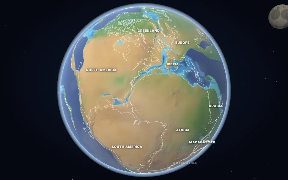
Earth 200 Million Years Ago: Pangea Begins to Break Up
What Earth looked like 200 million years ago: Pangea splitting as the Atlantic is born, lava floods, and the extinction that let dinosaurs take over.
 Spin it in 3D and move through time
Map: Ancient maps: PALEOMAP PaleoDEMs (Scotese & Wright 2018), CC BY 4.0 · Natural Earth.
About 201 million years ago, rifts split Pangea between North America and Africa. Floods of lava, the Central Atlantic Magmatic Province, poured out over millions of square kilometres; their remains are found today in Morocco, eastern North America and Brazil.
The gases from these eruptions drove the end-Triassic mass extinction. Many large reptiles disappeared, clearing the way for the dinosaurs to dominate the Jurassic. Small early mammals were already living alongside them.
Seawater began to flood into the rift. Over the next tens of millions of years it widened into the central Atlantic Ocean.
Events of the time
Manicouagan impact
214 million years ago · Quebec, Canada
An asteroid about 5 km across left a crater about 100 km wide, now a ring-shaped lake visible from space.
Central Atlantic lava floods
201 million years ago · Morocco and eastern North America
As Pangea rifted, lava erupted over millions of km² (the Central Atlantic Magmatic Province), driving the end-Triassic mass extinction.
▶ Watch it happen on the globe
Which land was under the sea 200 million years ago?
On the map nearest this age (200 million years ago, Late Triassic), about 22% of today’s land was under the sea at some point, some 32.2 million km². That makes it number 46 of the 80 maps from 535 to 5 million years ago, which run from 2% to 50%. Each map shows the greatest flooding of its stage, so no single moment had quite this much sea.
- Tethys Ocean
Permian to Miocene · Southern Europe, North Africa, the Middle East, Iran, the Himalaya and South-East Asia
The ocean between the northern and southern continents. As Africa, Arabia and India moved north it closed, raising the Alps and the Himalaya; the Mediterranean is what is left of it.
Was it under the sea? 14 of 42 cities
| Place today | 200 million years ago |
|---|---|
| Bangkok, Thailand | Shallow sea |
| Berlin, Germany | Shallow sea |
| Cairo, Egypt | Shallow sea |
| Calgary, Canada | Shallow sea |
| Delhi, India | Shallow sea |
| Hannover, Germany | Shallow sea |
| Kathmandu, Nepal | Shallow sea |
| London, United Kingdom | Shallow sea |
| Paris, France | Shallow sea |
| Perth, Australia | Shallow sea |
| Regina, Canada | Shallow sea |
| Riyadh, Saudi Arabia | Shallow sea |
| Rome, Italy | Shallow sea |
| Tehran, Iran | Shallow sea |
| Alice Springs, Australia | Land |
| Almaty, Kazakhstan | Land |
| Baku, Azerbaijan | Not modelled |
| Beijing, China | Land |
| Bismarck, United States | Land |
| Budapest, Hungary | Not modelled |
| Casper, Wyoming, United States | Land |
| Chicago, United States | Land |
| Dallas, United States | Land |
| Denver, United States | Land |
| Hays, Kansas, United States | Land |
| Johannesburg, South Africa | Land |
| Kansas City, United States | Land |
| Madrid, Spain | Land |
| Mexico City, Mexico | Land |
| Montgomery, Alabama, United States | Land |
| Moscow, Russia | Land |
| Nairobi, Kenya | Land |
| New York, United States | Land |
| Niamey, Niger | Land |
| Novosibirsk, Russia | Land |
| Richmond, Queensland, Australia | Land |
| Salt Lake City, United States | Land |
| São Paulo, Brazil | Land |
| Timbuktu, Mali | Land |
| Vienna, Austria | Land |
| Warsaw, Poland | Land |
| Winnipeg, Canada | Land |
1,241 marine fossil sites in the Paleobiology Database are dated closely enough to this map. Of those on today’s land, 94% fall in its shaded sea.
Seas: Ancient seas: PaleoCoastlines v7 (Kocsis & Scotese 2021), CC BY 4.0 · Fossils: Paleobiology Database.
Part of the Mesozoic Era & Age of the Dinosaurs.