
Paleozoic Era · Carboniferous Period
Earth 300 Million Years Ago: Coal Swamps and an Ice Age
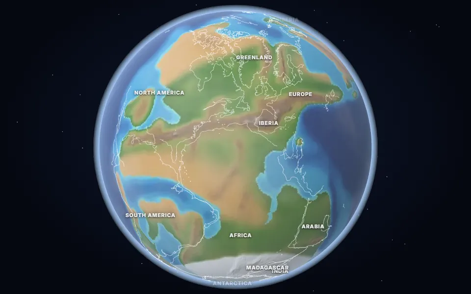
What Earth looked like 300 million years ago: tropical coal swamps, giant insects, ice sheets over southern Gondwana and Pangea almost complete.
 Spin it in 3D and move through time
Map: Ancient maps: PALEOMAP PaleoDEMs (Scotese & Wright 2018), CC BY 4.0 · Natural Earth.
Around 300 million years ago, at the end of the Carboniferous, vast swamp forests grew along the equator. Their buried wood became the coal of Europe and North America that later powered the Industrial Revolution.
Oxygen in the air was well above today’s 21%, perhaps 30% or more, which helped insects grow huge: the griffinfly Meganeura had a wingspan of about 70 cm. The first reptiles had appeared.
At the same time ice sheets covered southern Gondwana in the Late Paleozoic Ice Age, the longest of the last 500 million years. Gondwana and Laurussia had collided, and Pangea was nearly complete.
Events of the time
Coal swamp forests
300 million years ago · Joggins, Nova Scotia, Canada
Tree-sized club mosses and horsetails grew in tropical swamps; their buried remains became the coal of Europe and North America. The first reptiles have been found in hollow stumps here.
Pangea comes together
300 million years ago · Appalachians, Atlas and Variscan mountains
Gondwana collided with Laurussia, raising a mountain range as tall as the Himalaya along the join. Its worn-down roots are the Appalachians, the Atlas and the hills of Europe.
▶ Watch it happen on the globe
Which land was under the sea 300 million years ago?
On the map nearest this age (300 million years ago, Late Pennsylvanian), about 30% of today’s land was under the sea at some point, some 43.3 million km². That makes it number 33 of the 80 maps from 535 to 5 million years ago, which run from 2% to 50%. Each map shows the greatest flooding of its stage, so no single moment had quite this much sea.
Was it under the sea? 13 of 42 cities
| Place today | 300 million years ago |
|---|---|
| Bangkok, Thailand | Shallow sea |
| Beijing, China | Shallow sea |
| Bismarck, United States | Shallow sea |
| Cairo, Egypt | Shallow sea |
| Calgary, Canada | Shallow sea |
| Chicago, United States | Shallow sea |
| Hays, Kansas, United States | Shallow sea |
| Kansas City, United States | Shallow sea |
| Moscow, Russia | Shallow sea |
| Novosibirsk, Russia | Shallow sea |
| Rome, Italy | Shallow sea |
| Salt Lake City, United States | Shallow sea |
| Tehran, Iran | Shallow sea |
| Alice Springs, Australia | Land |
| Almaty, Kazakhstan | Land |
| Baku, Azerbaijan | Not modelled |
| Berlin, Germany | Land |
| Budapest, Hungary | Not modelled |
| Casper, Wyoming, United States | Land |
| Dallas, United States | Land |
| Delhi, India | Land |
| Denver, United States | Land |
| Hannover, Germany | Land |
| Johannesburg, South Africa | Land |
| Kathmandu, Nepal | Land |
| London, United Kingdom | Land |
| Madrid, Spain | Land |
| Mexico City, Mexico | Land |
| Montgomery, Alabama, United States | Land |
| Nairobi, Kenya | Land |
| New York, United States | Land |
| Niamey, Niger | Land |
| Paris, France | Land |
| Perth, Australia | Land |
| Regina, Canada | Land |
| Richmond, Queensland, Australia | Land |
| Riyadh, Saudi Arabia | Land |
| São Paulo, Brazil | Land |
| Timbuktu, Mali | Land |
| Vienna, Austria | Land |
| Warsaw, Poland | Land |
| Winnipeg, Canada | Land |
841 marine fossil sites in the Paleobiology Database are dated closely enough to this map. Of those on today’s land, 94% fall in its shaded sea.
Seas: Ancient seas: PaleoCoastlines v7 (Kocsis & Scotese 2021), CC BY 4.0 · Fossils: Paleobiology Database.
Part of the Paleozoic Era & The Cambrian Explosion.