
Mesozoic Era · Jurassic Period
Earth 150 Million Years Ago: The Late Jurassic
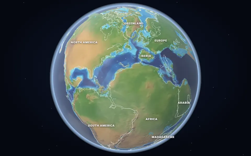
What Earth looked like 150 million years ago in the Late Jurassic: giant sauropods, Archaeopteryx and a young, narrow Atlantic Ocean.
 Spin it in 3D and move through time
Map: Ancient maps: PALEOMAP PaleoDEMs (Scotese & Wright 2018), CC BY 4.0 · Natural Earth.
In the Late Jurassic, giant long-necked sauropods such as Diplodocus and Brachiosaurus roamed North America, preyed on by Allosaurus. Archaeopteryx, a feathered dinosaur that links dinosaurs and birds, lived on islands in a shallow sea in what is now Germany.
The central Atlantic was a young ocean between North America and Africa, while Gondwana was beginning to split into an eastern half (Antarctica, India, Australia, Madagascar) and a western half (South America and Africa).
The climate was warm, with no ice at the poles, and shallow seas covered parts of Europe.
Which land was under the sea 150 million years ago?
On the map nearest this age (150 million years ago, Late Jurassic), about 12% of today’s land was under the sea at some point, some 17.0 million km². That makes it number 70 of the 80 maps from 535 to 5 million years ago, which run from 2% to 50%. Each map shows the greatest flooding of its stage, so no single moment had quite this much sea.
- Tethys Ocean
Permian to Miocene · Southern Europe, North Africa, the Middle East, Iran, the Himalaya and South-East Asia
The ocean between the northern and southern continents. As Africa, Arabia and India moved north it closed, raising the Alps and the Himalaya; the Mediterranean is what is left of it.
- Sundance Sea
Middle and Late Jurassic · Wyoming, Montana, the Dakotas, Utah and Alberta
An arm of the sea that reached south from the Arctic into Wyoming, Montana and the Dakotas, before the dinosaur plains of the Morrison Formation.
- Turgai Strait
Jurassic to Oligocene, on and off · Western Siberia and Kazakhstan, east of the Urals
A sea east of the Ural Mountains that linked the Arctic to the Tethys and kept Europe apart from Asia for animals that could not swim. The map under-draws it.
Was it under the sea? 6 of 42 cities
| Place today | 150 million years ago |
|---|---|
| Kathmandu, Nepal | Shallow sea |
| London, United Kingdom | Shallow sea |
| Moscow, Russia | Shallow sea |
| Rome, Italy | Shallow sea |
| Tehran, Iran | Shallow sea |
| Vienna, Austria | Shallow sea |
| Alice Springs, Australia | Land |
| Almaty, Kazakhstan | Land |
| Baku, Azerbaijan | Not modelled |
| Bangkok, Thailand | Land |
| Beijing, China | Land |
| Berlin, Germany | Land |
| Bismarck, United States | Land |
| Budapest, Hungary | Not modelled |
| Cairo, Egypt | Land |
| Calgary, Canada | Land |
| Casper, Wyoming, United States | Land |
| Chicago, United States | Land |
| Dallas, United States | Land |
| Delhi, India | Land |
| Denver, United States | Land |
| Hannover, Germany | Land |
| Hays, Kansas, United States | Land |
| Johannesburg, South Africa | Land |
| Kansas City, United States | Land |
| Madrid, Spain | Land |
| Mexico City, Mexico | Land |
| Montgomery, Alabama, United States | Land |
| Nairobi, Kenya | Land |
| New York, United States | Land |
| Niamey, Niger | Land |
| Novosibirsk, Russia | Land |
| Paris, France | Land |
| Perth, Australia | Land |
| Regina, Canada | Land |
| Richmond, Queensland, Australia | Land |
| Riyadh, Saudi Arabia | Land |
| Salt Lake City, United States | Land |
| São Paulo, Brazil | Land |
| Timbuktu, Mali | Land |
| Warsaw, Poland | Land |
| Winnipeg, Canada | Land |
1,455 marine fossil sites in the Paleobiology Database are dated closely enough to this map. Of those on today’s land, 64% fall in its shaded sea, one of the weaker fits.
Seas: Ancient seas: PaleoCoastlines v7 (Kocsis & Scotese 2021), CC BY 4.0 · Fossils: Paleobiology Database.
Part of the Mesozoic Era & Age of the Dinosaurs.