Skip to content
YearMaps
Vanuatu · Islands

Largest Islands of Vanuatu

Vanuatu is the largest of the 11 islands recorded for Vanuatu, at 160,846 km², ahead of Espiritu Santo at 4,093 km². The full list follows.

How this list is built: Ranked by mapped area. An island divided between countries is listed under each, with the area of the whole island. It covers the islands indexed in YearMaps, drawn from open geospatial data, and is not an exhaustive national register.

Islands Listed
11
Top Ranked
160,846 km²
Vanuatu
Second
4,093 km²
Espiritu Santo
Profiled Below
11
Photo, encyclopedia text and figures
Largest Islands of Vanuatu
#NameArea
1Vanuatu160,846 km²
2Espiritu Santo4,093 km²
3Malakula2,112 km²
4Erromango893 km²
5Éfaté890 km²
6Ambrym694 km²
7Tanna581 km²
8Pentecost484 km²
9Gaua336 km²
10Vanua Lava306 km²
11Anatom158 km²

The Islands of Vanuatu in Detail

The 11 islands above that have an encyclopedia article, in the same order, each with its photograph, figures and the places around it.

Vanuatu
Image via Wikimedia Commons (author and licence on the file page).

Vanuatu

Island group · 160,846 km²

Vanuatu is an island group in Oceania (Melanesia), covering an estimated 160,846 km².

Vanuatu, officially the Republic of Vanuatu (French: République de Vanuatu; Bislama: Ripablik blong Vanuatu), is an archipelagic country in Melanesia located in the South Pacific Ocean. The archipelago, which is of volcanic origin, is 1,750 km (1,090 mi) east of northern Australia, 540 km (340 mi) northeast of New Caledonia, east of New Guinea, southeast of Solomon Islands, and west of Fiji.

Vanuatu was first inhabited by Melanesian people. The first Europeans to visit the islands were a Spanish expedition led by Portuguese navigator Fernandes de Queirós, who arrived on the largest island, Espíritu Santo, in 1606. Queirós claimed the archipelago for Spain, as part of the colonial Spanish East Indies and named it La Austrialia del Espíritu Santo.

In the 1880s, France and the United Kingdom claimed parts of the archipelago, and in 1906, they agreed on a framework for jointly managing the archipelago as the New Hebrides – through an Anglo-French condominium.

In the 1970s, an independence movement arose, and the Republic of Vanuatu was founded in 1980.

Adapted from Wikipedia: Vanuatu (CC BY-SA 4.0).

Feature class
Island group
Mapped extent
160,846 km²
Size rank
#42 of 445 islands
Region
Oceania
Subregion
Melanesia
Coordinates
-14.0050°, 166.7566°
Summits:
Mount Tabwemasana (1,877 m), Mont Panié (1,628 m), Mount Popomanaseu (2,335 m)
Ranges:
Owen Stanley Range (Oceania), Great Dividing Range (Oceania)
Settlements:
Port Vila (447 km), Honiara (898 km), Nouméa (919 km)

View on the live map

More about Vanuatu

Geography

Vanuatu is a Y-shaped archipelago consisting of about 83 relatively small, geologically newer islands of volcanic origin (65 of them inhabited), with about 1,300 kilometres (810 mi) between the most northern and southern islands. Two of these islands (Matthew and Hunter) are also claimed and controlled by France as part of the French collectivity of New Caledonia. The country lies between latitudes 13°S and 21°S and longitudes 166°E and 171°E.

The fourteen of Vanuatu's islands that have surface areas of more than 100 square kilometres (39 sq mi) are, from largest to smallest: Espiritu Santo, Malakula, Efate, Erromango, Ambrym, Tanna, Pentecost, Epi, Ambae or Aoba, Gaua, Vanua Lava, Maewo, Malo and Aneityum or Anatom.

History

The history of Vanuatu before European colonisation is mostly obscure because of the lack of written sources which predate European contact and because only limited archaeological work has been conducted; Vanuatu's volatile geology and climate are also likely to have destroyed or hidden many prehistoric sites. Archaeological evidence gathered since the 1980s supports the theory that the Vanuatuan islands were first settled about 3,000 years ago, in the period roughly between 1100 BCE and 700 BCE. These were almost certainly people of the Lapita culture.

Demographics

According to the 2020 census, Vanuatu had a population of 300,019. Men outnumber women, with the population consisting of 151,597 men and 148,422 women in 2020. The population is predominantly rural, but Port Vila and Luganville have tens of thousands of residents. An English coinage termed the inhabitants of Vanuatu as Ni-Vanuatu. The Ni-Vanuatu are primarily of Melanesian descent, with the remainder made up of a mix of Europeans, Asians, and other Pacific islanders. The community of Vietnamese in Vanuatu comprises most of the country's Asian population. The Vietnamese community has declined from 10% of Vanuatu's population in 1929 to about 0.3% (or 1,000 individuals) in 2017.

Economy

Vanuatu was ranked the 173rd safest investment destination in the world in the March 2011 Euromoney Country Risk rankings. In 2015, Vanuatu was ranked the 84th most economically free country by The Heritage Foundation and The Wall Street Journal. The economy grew about 6% in the early 2000s. This is higher than in the 1990s, when GDP rose less than 3%, on average. One report from the Manila-based Asian Development Bank about Vanuatu's economy gave mixed reviews and noted that the economy grew at a 5.9% rate from 2003 to 2007.

Vanuatu became the 185th member of the World Intellectual Property Organization (WIPO) in December 2011.

Exports include copra, kava, beef, cocoa, and timber; imports include machinery and equipment, foodstuffs, and fuels. In contrast, mining activity is very low.

Sections adapted from Wikipedia: Vanuatu (CC BY-SA 4.0).

Vanuatu: Key Facts

Key facts about Vanuatu
Area12,190 km²
Population300,019 (2020)
Highest pointMount Tabwemasana

Facts from Wikidata Q686 (CC0).

Visiting Vanuatu

Vanuatu (previously known as the New Hebrides Islands) is an archipelago nation in the southwest Pacific Ocean. The archipelago more than 80 islands includes deserted sand beaches, remote beauty, tribal communities and world-class deep-sea diving.

Travel notes adapted from Wikivoyage: Vanuatu (CC BY-SA 4.0).

Espiritu Santo
Image via Wikimedia Commons (author and licence on the file page).

Espiritu Santo

Island group · 4,093 km²

Espiritu Santo is an island group in Oceania (Melanesia), covering an estimated 4,093 km².

Espiritu Santo (UK: , US: ; French: [ɛspiʁity sɑ̃to]), usually just called Santo, is the largest island in the nation and archipelago of Vanuatu (formerly the New Hebrides), with an area of 3,955.5 km2 (1,527.2 sq mi), although Efate, on which the capital city of Port Vila is located, has a larger population. As of 2020, the population of Santo was 37,328. Luganville is the only true town on the island.

Adapted from Wikipedia: Espiritu Santo (CC BY-SA 4.0).

Feature class
Island group
Mapped extent
4,093 km²
Size rank
#205 of 445 islands
Region
Oceania
Subregion
Melanesia
Coordinates
-15.3668°, 166.9124°
Summits:
Mount Tabwemasana (1,877 m), Mont Panié (1,628 m), Mont Humboldt (1,618 m)
Ranges:
Owen Stanley Range (Oceania), Great Dividing Range (Oceania)
Settlements:
Port Vila (303 km), Nouméa (768 km), Honiara (1,003 km)

View on the live map

More about Espiritu Santo

Geography

The island belongs to the archipelago of Vanuatu in the Pacific region of Melanesia. It is in the Sanma Province of Vanuatu. The town of Luganville, on Espiritu Santo's southeast coast, is Vanuatu's second-largest settlement and the provincial capital. Roads run north and west from Luganville, but most of the island is far from the limited road network.

Around Espiritu Santo lie a number of small islands and islets. Among them are: Dany Island, Araki, Elephant Island, Sakao, Lataroa, Lataro, Thion, Malohu, Malwepe, Malvapevu, Malparavu, Maltinerava, Oyster Island, Tangoa, and Bokissa.

Vanuatu's highest peak is the 1,879-metre (6,165 ft) Mount Tabwemasana in west-central Espiritu Santo.

History

A Spanish expedition of three ships, led by Portuguese explorer Pedro Fernandes de Queirós, landed in 1606 at Big Bay on the north side of the island. Queirós named the land La Austrialia [sic] del Espíritu Santo in acknowledgment of the Spanish king's descent from the royal House of Austria, and believing he had arrived in the Great Southern Continent, Terra Australis. They entered the bay on 1 and 2 May: the latter being the day of Saints Philip and James, Queirós named it Bahía de San Felipe y Santiago. The local chief tried to chase the Spanish explorers back to their ships, which led to an exchange of arrows and musket-fire, in which the chief was killed.

Demographics

In the 2009 census, the population of Santo was around 40,000. In the 2020 census, the population of the Santo Rural Constituency represented 13 per cent of the national population of Vanuatu, with 37,328 individuals. (The island of Efate recorded 50,340 persons, representing 17 % of national population, in the same census.)

Most of the people are Christians. The largest church groups on the island are the Presbyterian Church of Vanuatu, the Roman Catholic Church, and the Church of Melanesia (Anglican). Also active are the Apostolic Church, the Church of Christ, the Seventh-day Adventist Church, and others.

Economy and infrastructure

Luganville is the only true town on the island; the rest of the island is dotted with small villages. From Luganville, three "main roads" emerge. Main Street leaves the town to the west and winds along the south coast of the island for about 40 km (25 mi) ending at the village of Tasiriki on the southwest coast. Canal Road runs along the southern and eastern coasts of the island, north through Hog Harbor and Golden Beach, ending at Port Olry. Big Bay Highway splits off from Canal Road near Turtle Bay on the east coast, runs generally west to the mountains, and then it leads north to Big Bay. The international airport is about 5 km (3 mi) east of the center of Luganville. Numerous rivers run to the coastline from the mountains of the island.

Sections adapted from Wikipedia: Espiritu Santo (CC BY-SA 4.0).

Espiritu Santo: Key Facts

Key facts about Espiritu Santo
Area3,956 km²
Highest pointMount Tabwemasana
Surrounded byPacific Ocean

Facts from Wikidata Q337524 (CC0).

Malakula
Image via Wikimedia Commons (author and licence on the file page).

Malakula

Island group · 2,112 km²

Malakula is an island group in Oceania (Melanesia), covering an estimated 2,112 km².

Malekula, also spelled Malakula, is the second-largest island in the nation of Vanuatu, an archipelago of Melanesia in the South Pacific.

Adapted from Wikipedia: Malekula (CC BY-SA 4.0).

Feature class
Island group
Mapped extent
2,112 km²
Size rank
#246 of 445 islands
Region
Oceania
Subregion
Melanesia
Coordinates
-16.3707°, 167.5494°
Summits:
Mount Tabwemasana (1,877 m), Mont Panié (1,628 m), Mont Humboldt (1,618 m)
Ranges:
Owen Stanley Range (Oceania), Great Dividing Range (Oceania)
Settlements:
Port Vila (172 km), Nouméa (665 km), Nandi (1,061 km)

View on the live map

More about Malakula

History

Malakula was inhabited for centuries by the Ni-Vanuatu people before Europeans encountered it. The first Europeans to sight the island were the members of the Spanish expedition of Pedro Fernández de Quirós, in 1606.

In 1914 and 1915, the British anthropologist John Layard lived on Malakula, doing anthropological fieldwork, taking notes, making phonographic records, and taking more than 400 photographs. When he returned to Britain, he donated copies of his photographs on plates to the Museum of Archaeology and Anthropology, at Cambridge.

Demographics

Nearly thirty different languages are spoken on the island. Unlike some earlier classifications, linguist and Oceanic languages specialist John Lynch (2016) considered the Malakula languages to form a coherent group. The two tribes living on Malakula are the Big Nambas, who live in the northern area of the island, and the Small Nambas, who live in the central part of the southern area. The tribes’ names are a reference to the size of the penis sheath worn by the men, which are made out of banana or pandanus leaves.

Until recently, it was the custom in the culture of these tribes to bind infants' skulls in order to permanently alter the shape of their heads. Cone-shaped skulls were considered a sign of higher social status.

Economy and services

Malakula's economy is largely based on agriculture. The island has extensive copra plantations on the eastern coastal plains around Norsup and Lakatoro. The largest copra-producing plantation in Vanuatu is in Norsup.

In 1939, a copra cooperative was set up at Matanvat in northern Malakula. For a while it turned to cargo cult activities, but after 1950 it resumed copra production.

Both Norsup and Lakatoro have telephones and 24-hour electricity. Norsup is the site of the provincial hospital. Lakatoro has more stores than Norsup. It has a market house, a branch of the National Bank of Vanuatu, and an Air Vanuatu office. It is also the site of the island's main wharf and the administrative centre for Malampa province (which includes Malekula, Ambrym and Paama).

Location

Malakula is separated from the islands of Espiritu Santo and Malo by the Bougainville Strait. Lakatoro, the capital of Malampa Province, is situated on Malakula's northeastern shore and is the largest settlement on the island. Just off the northeastern coast of Malakula, there is a group of islands called the Small Islands, including, in order from north to south: Vao, Atchin, Wala, Rano, Norsup, Uripiv, and Uri. Also off the coast: Tomman Island to the southwest; Akhamb Island to the south; and the Maskelynes Islands to the southeast (including Sakao Island and Uluveo).

Malakula has a maximum elevation of 879 m. Its peak is called Mt. Liambele. In 1768, Louis Antoine de Bougainville gave his name to the straits that separate Malakula from Santo.

Sections adapted from Wikipedia: Malekula (CC BY-SA 4.0).

Malakula: Key Facts

Key facts about Malakula
Area2,041 km²
Population20,000
Surrounded byPacific Ocean

Facts from Wikidata Q618594 (CC0).

Erromango
Image via Wikimedia Commons (author and licence on the file page).

Erromango

Island · 893 km²

Erromango is an island in Oceania (Melanesia), covering an estimated 893 km².

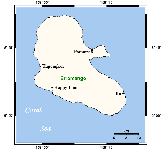
Erromango is the fourth largest island in the Vanuatu archipelago. With a land area of 891.9 square kilometres (344.4 sq mi), it is the largest island in Tafea Province, the southernmost of Vanuatu's six administrative regions.

Adapted from Wikipedia: Erromango (CC BY-SA 4.0).

Feature class
Island
Mapped extent
893 km²
Size rank
#303 of 445 islands
Region
Oceania
Subregion
Melanesia
Coordinates
-18.8161°, 169.1001°
Summits:
Mont Humboldt (1,618 m), Mount Tabwemasana (1,877 m), Mont Panié (1,628 m)
Ranges:
Great Dividing Range (Oceania), Owen Stanley Range (Oceania)
Settlements:
Port Vila (146 km), Nouméa (473 km), Nandi (885 km)

View on the live map

More about Erromango

Geography

The total area of Erromango is 891.9 km2. It measures approximately 48 km from the north-west tip to the south-east, and is between 20 and 30 kilometres wide. Its highest point is Mount Santop, at 886m. The island is situated between latitude 18°37'S and 18°59'S and 168°59'E and 168°20'E. Vete Manung Island is located 15 km off the north-east coast of Erromango.

In the middle of the east coast is a promontory formed by the volcanic cone of Mount Rantop. 6 km off the east coast is an uninhabited islet named Vetemanu (English name Goat Island) of approximately 12ha in area.

The island is part of the Vanuatu rainforests ecoregion, within the East Melanesian Islands biogeographic region.

History

Erromango was first settled by humans around 3,000 years ago, as part of the Lapita migration out of south-east Asia into island Melanesia. The Lapita people brought with them domestic animals such as pigs and chickens and food plants such as yam and breadfruit.

Two sites on Erromango, Ifo and Ponamla, have yielded significant archaeological evidence of habitation by Lapita and post-Lapita peoples, including pottery sherds, adzes, marine shell artifacts and cooking stones.

Erromango contains numerous caves that provided refuge from tribal warfare and cyclones. Human use of these caves has been dated to 2,800–2,400 years before the present. Some of the caves contain rock art and petroglyphs that have been identified with clan motifs and traditional stories.

Geology

Erromango, like most other islands of the Vanuatu archipelago, is volcanic in origin. It is composed of basalt and andesite from the late Miocene-Recent periods and is situated along a Pliocene-Recent volcanic chain that is moving to the north-northwest. Most of the island is fringed with a platform of uplifted coral reef limestone dating from the Late Pleistocene and Holocene.

Erromango was formed during a prolonged period of volcanic activity took place between 6 and 1 Ma.

The island is an ancient underwater volcano that has been raised 100-300m above sea level by tectonic uplift, forming a plateau on which stand three sets of eroded volcanic cones in the centre, north and east of the island.

Sections adapted from Wikipedia: Erromango (CC BY-SA 4.0).

Erromango: Key Facts

Key facts about Erromango
Area888 km²
Population1,950
Surrounded byPacific Ocean

Facts from Wikidata Q859646 (CC0).

Éfaté
Image via Wikimedia Commons (author and licence on the file page).

Éfaté

Island · 890 km²

Éfaté is an island in Oceania (Melanesia), covering an estimated 890 km².

Efate (French: Éfaté), originally named Sandwich Island and also known as Île Vate (French: [il vat]) or just Vate, is an island in the Pacific Ocean. It is part of the Shefa Province in Vanuatu, and the capital city, Port Vila, is located on the island.

Adapted from Wikipedia: Efate (CC BY-SA 4.0).

Feature class
Island
Mapped extent
890 km²
Size rank
#304 of 445 islands
Region
Oceania
Subregion
Melanesia
Coordinates
-17.6556°, 168.3907°
Summits:
Mount Tabwemasana (1,877 m), Mont Panié (1,628 m), Mont Humboldt (1,618 m)
Ranges:
Owen Stanley Range (Oceania), Great Dividing Range (Oceania)
Settlements:
Port Vila (12 km), Nouméa (551 km), Nandi (956 km)

View on the live map

More about Éfaté

Geography

Efate's land area of 899.5 square kilometres (347.3 sq mi) makes it Vanuatu's third largest island.

Its geological past was heavily volcanic, meaning that a lava shelf surrounds much of the island. Its highest mountain is Mount Macdonald, with a height of 647 metres (2,123 ft). The terrain is rugged.

Efate's climate is warm and humid, and the island mostly covered by tropical rainforest.

Port Vila is the capital city, and lies on the southwest coast in Shefa Province. Its harbour is Mélé Bay. Pango is a community located on the southern coast of Efate, 7 km (4.3 mi) away from Port Vila, and is considered peri-urban.

On the other side of the island, on the northwest coast, is the village of Port Havannah.

History

Captain James Cook named the island Sandwich Island in honour of his patron, the Earl of Sandwich, on his 1774 voyage on HMS Resolution.

Coconut trees were planted on large plantations by European settlers in the islands in the late 1800s, owing to the growing demand for copra, the dried flesh of the coconut that contains the oil. The first of these coconut plantations was on Efate, planted in 1877.

During the 19th century, Australian, British, French, and German settlers settled in the territory of the New Hebrides. In 1878, the United Kingdom and France declared all of the New Hebrides to be neutral territory. In 1887, the Anglo-French Joint Naval Commission took charge of the territory.

Demographics

Efate is the most populous island in Vanuatu, with 50,340 persons, representing 17 per cent of the national population, as recorded in the 2020 census. Most inhabitants of Efate live in Port Vila, the national capital.

There are roughly half a dozen languages spoken on Efate, including Central Vanuatu languages such as Nakanamanga (Nguna, North Efate), Namakura (Makura, Namakir), Nafsan (Erakor, South Efate), Lelepa (Havannah Harbour), and Eton, as well as the Polynesian outlier language Mele-Fila. The North Efate and South Efate languages are not very closely related, and when missionaries became active on the island, they encouraged the use of a zonal auxiliary language, Efatese, based on various languages of Efate.

Economy and tourism

The economy of Vanuatu is largely dependent on subsistence agriculture and tourism. Since the 2010s, planting of coconut plantations and the production of coconut products has increased, after falling into neglect in the 1980s.

The capital of Port Vila is the hub of tourism in Vanuatu, receiving tourists by air, cruise ships, and the yachts. Due to the British and French influence, both cuisines are readily available in the capital. There are also Chinese eateries across Vila and the Mummas Market downtown. Outside of Port Vila, most people live a traditional lifestyle, cooking island food or aelan kakae, and swimming at the beach.

Sections adapted from Wikipedia: Efate (CC BY-SA 4.0).

Éfaté: Key Facts

Key facts about Éfaté
Area900 km²
Population50,000
Highest pointMount McDonald
Surrounded byPacific Ocean

Facts from Wikidata Q266594 (CC0).

Ambrym
Image via Wikimedia Commons (author and licence on the file page).

Ambrym

Island · 694 km²

Ambrym is an island in Oceania (Melanesia), covering an estimated 694 km².

Ambrym is a volcanic island in Malampa Province in the archipelago of Vanuatu. It is located near the center of the archipelago of Vanuatu, and also hosts one of the most active volcanoes in the world, which includes lava lakes in two craters near the summit. It is currently the least populous island in the country.

Adapted from Wikipedia: Ambrym (CC BY-SA 4.0).

Feature class
Island
Mapped extent
694 km²
Size rank
#315 of 445 islands
Region
Oceania
Subregion
Melanesia
Coordinates
-16.2493°, 168.1347°
Summits:
Mount Tabwemasana (1,877 m), Mont Panié (1,628 m), Mont Humboldt (1,618 m)
Ranges:
Owen Stanley Range (Oceania), Great Dividing Range (Oceania)
Settlements:
Port Vila (166 km), Nouméa (692 km), Nandi (1,002 km)

View on the live map

More about Ambrym

Geography

Located near the center of the Vanuatu archipelago, Ambrym is roughly triangular in shape, about 50 km (31 mi) wide. With 677.7 square kilometres (261.7 mi2) of surface area, it is the fifth largest island in the country. The summit at the centre of the island is dominated by a desert-like caldera, which covers an area of 100 square kilometres (39 mi2). With the exception of human settlements, the rest of the island is covered by a dense jungle.

Demographics

With the neighbouring island of Malakula and a few smaller islands, Ambrym forms Malampa Province. The population of 7,275 inhabitants lives mainly off coconut plantations in the three corners of the island.

Sections adapted from Wikipedia: Ambrym (CC BY-SA 4.0).

Ambrym: Key Facts

Key facts about Ambrym
Area678 km²
Population7,385 (2016)
Surrounded byPacific Ocean

Facts from Wikidata Q459948 (CC0).

Tanna
Image via Wikimedia Commons (author and licence on the file page).

Tanna

Island · 581 km²

Tanna is an island in Oceania (Melanesia), covering an estimated 581 km².

Tanna (sometimes misspelled Tana) is an island in southern Vanuatu. Tanna is the most populous island of Tafea Province, and the third most populous in the country (after Efate and Espiritu Santo). It is home to five indigenous languages, which also rank among the most widely spoken in the whole archipelago, ranging from 3,500 to 11,500 speakers.

Tanna has been featured in numerous documentaries and TV shows around the world. This is partly due to Mount Yasur, an active volcano and a major tourist attraction. It is also of interest for its vibrant Melanesian culture, through dances and festivals. The island has attracted the attention of many anthropologists for its cargo cults.

Adapted from Wikipedia: Tanna (island) (CC BY-SA 4.0).

Feature class
Island
Mapped extent
581 km²
Size rank
#325 of 445 islands
Region
Oceania
Subregion
Melanesia
Coordinates
-19.5533°, 169.3872°
Summits:
Mont Humboldt (1,618 m), Mont Panié (1,628 m), Mount Tabwemasana (1,877 m)
Ranges:
Great Dividing Range (Oceania), Owen Stanley Range (Oceania)
Settlements:
Port Vila (232 km), Nouméa (429 km), Nandi (868 km)

View on the live map

More about Tanna

Geography

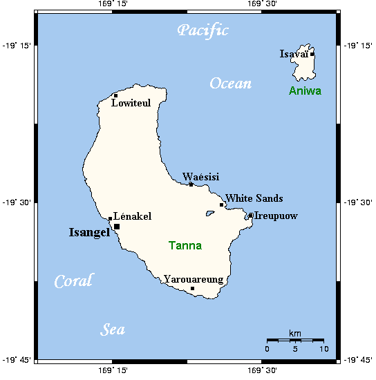
Tanna is 40 kilometres (25 miles) long and 19 kilometres (12 miles) wide, with a total area of 550 square kilometres (212 square miles). Its highest point is the 1,084-metre (3,556-foot) summit of Mount Tukosmera in the south of the island.

Siwi Lake was located in the east, northeast of the peak, close to the coast, until April 2000 when following unusually heavy rain, the lake burst down the valley into Sulphur Bay, destroying the village with no loss of life. Mount Yasur is an active volcano on the southeast coast.

History

Tanna was first settled about 400 BC by Melanesians from the surrounding islands.

The glowing light of Mount Yasur attracted James Cook, the first European to visit the island, in August 1774, where he landed in an inlet on the southeastern tip of the island that he named Port Resolution after his ship HMS Resolution.

Cook found a numerous local population of several thousand people at Port Resolution. He fired muskets and cannon to make the people aware of his military superiority and was able to go ashore. Cook found the villagers had extensive plantations of sugar-cane, plaintains, yams and fruit trees. He was able to obtain lumber, water and food supplies in exchange for trinkets and several dogs.

Culture and economy

Tanna is the most populous island in Tafea Province, and one of the most populous islands in the country with a population of about 29,000 in 2009, which grew to 30,770 in 2015. Isangel, the provincial administrative capital, is on the west coast near the island's largest town of Lénakel. Tanna is populated almost entirely by Melanesians, and they follow a more traditional lifestyle than many other islands. Some of the higher altitude villages are known as kastom villages, where modern inventions are restricted, the inhabitants wear penis sheaths (Bislama: nambas) and grass skirts, and the children do not go to public school.

Sections adapted from Wikipedia: Tanna (island) (CC BY-SA 4.0).

Tanna: Key Facts

Key facts about Tanna
Area555 km²
Population28,799
Highest pointMount Tukosmera
Surrounded byPacific Ocean

Facts from Wikidata Q378281 (CC0).

Pentecost
Image via Wikimedia Commons (author and licence on the file page).

Pentecost

Island · 484 km²

Pentecost is an island in Oceania (Melanesia), covering an estimated 484 km².

Pentecost is one of the 83 islands that make up the South Pacific nation of Vanuatu.

It lies 190 kilometres (120 mi) due north of capital Port Vila. Pentecost is known as Pentecôte in French and Pentekos in Bislama. The island was known in its native languages by names such as Vanu Aroaroa, although these names are not in common use today. Pentecost has also been referred to as Raga or Araga, a tribal name that originated in the north but is now widely applied to the whole island. In old sources, it is occasionally referred to as Whitsuntide Island.

Adapted from Wikipedia: Pentecost (island) (CC BY-SA 4.0).

Feature class
Island
Mapped extent
484 km²
Size rank
#333 of 445 islands
Region
Oceania
Subregion
Melanesia
Coordinates
-15.8715°, 168.2173°
Summits:
Mount Tabwemasana (1,877 m), Mont Panié (1,628 m), Mont Humboldt (1,618 m)
Ranges:
Owen Stanley Range (Oceania), Great Dividing Range (Oceania)
Settlements:
Port Vila (207 km), Nouméa (735 km), Nandi (1,002 km)

View on the live map

More about Pentecost

Geography

Pentecost is a lush, mountainous island which stretches north to south over some 60 kilometres (37 mi). It has an area of 490 square kilometres (190 sq mi). The mountain range, of which the highest is Mount Vulmat (947 metres, 3,107 ft), marks the dividing line between the humid, rainy eastern coast and the more temperate western coast. The coastal plains, cross-cut by small torrents, are generally very green and ideally suited for plantations and livestock.

The climate on Pentecost is humid tropical. The average annual rainfall is about 3,500 mm of rain. There are two seasons in the year: the rainy season, which lasts from November to April, and the dry season, which lasts from May to October. The island is subject to frequent cyclones and earthquakes.

History and customs

Some Bule people of Pentecost trace their origins to Nuenue, a woman to whom was given the skill of weaving by the creator, Tagaro. She travelled throughout the island, passing on the skill to others, and, in exchange, she was given land. As a result, the descendants of Nuenue are entitled to land wherever Nuenue settled.

The first Western sighting of Pentecost was by the Spanish expedition of Pedro Fernandez de Quiros in April 1606. Pentecost was again sighted on the day of Pentecost, 22 May 1768, by Louis Antoine de Bougainville. It was also sighted by Captain James Cook, during his voyage through the New Hebrides (now Vanuatu) in 1774. It was influenced by successive Christian missionaries but traditional customs there remain strong.

Lifestyle and economy

There are no real towns on Pentecost. Most islanders live in small rural villages, surviving by subsistence agriculture and growing cash crops. Taro, a root vegetable well-suited to Pentecost's wet climate, is the staple food. Manioc (cassava), yams, bananas, kumala (sweet potato), coconuts, island cabbage, pawpaw (papaya), nakavika (rose apples), citrus, sugar cane, cacao, mangoes, pineapples, nuts, and European vegetables are also grown for local consumption.

Vegetables are often grated into a paste, wrapped in large leaves, baked in an earthen oven and covered with coconut cream to create 'laplap', a savoury pudding.

Sections adapted from Wikipedia: Pentecost (island) (CC BY-SA 4.0).

Pentecost: Key Facts

Key facts about Pentecost
Area490 km²
Population16,843
Surrounded byPacific Ocean

Facts from Wikidata Q960808 (CC0).

Gaua
Image via Wikimedia Commons (author and licence on the file page).

Gaua

Island · 336 km²

Gaua is an island in Oceania (Melanesia), covering an estimated 336 km².

Gaua [gawa] (formerly known as Santa Maria Island) is the largest and second most populous of the Banks Islands in Torba Province in northern Vanuatu. It covers 342 km2.

Adapted from Wikipedia: Gaua (CC BY-SA 4.0).

Feature class
Island
Mapped extent
336 km²
Size rank
#355 of 445 islands
Region
Oceania
Subregion
Melanesia
Coordinates
-14.2367°, 167.5032°
Summits:
Mount Tabwemasana (1,877 m), Mont Panié (1,628 m), Mont Humboldt (1,618 m)
Ranges:
Owen Stanley Range (Oceania), Great Dividing Range (Oceania)
Settlements:
Port Vila (398 km), Nouméa (899 km), Honiara (980 km)

View on the live map

More about Gaua

Geography

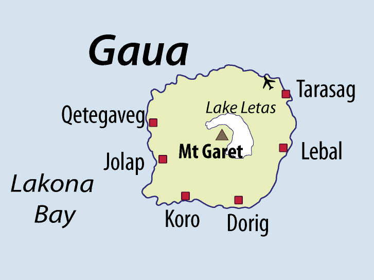
Gaua is subject to frequent earthquakes and cyclones. The climate is humid tropical; the average annual rainfall exceeds 3500 mm. It has rugged terrain, reaching up to Mount Gharat (797 m), the peak of the active stratovolcano which lies at the center of the island. Its most recent eruption was in 2013. The volcano has a 6 × 9 km caldera, within which lies a crater lake, known as Lake Letas, which is the largest lake in Vanuatu. To the east of the lake is Siri Waterfall (120 m drop).

Natural history

Gaua's geology is fairly typical of an immature volcanic island arc. The oldest part of the island is the southwestern corner, which consists largely of primitive basalts and ankaramites. Most of the island is covered by the Santa Maria Pyroclastic Series, a mafic ignimbrite unit that was produced by the eruption that formed the caldera. Gaua is rare in hosting a mafic ignimbrite, as most similarly explosive eruptions are more silicic; other examples include Masaya in Nicaragua, and on Ambrym, and Tanna, also in Vanuatu. The eruption of the SMPS was also associated with the activation of ring faults, and the production of parasitic volcanic cones around the upper slopes of the volcano.

Economy

The livelihood of the people of Gaua is based on the agricultural economy that is traditional throughout of Melanesia: a combination of fishing and horticulture.

The island is served by Gaua Airport, which is located in the northeast corner of the island.

Sections adapted from Wikipedia: Gaua (CC BY-SA 4.0).

Gaua: Key Facts

Key facts about Gaua
Area328 km²
Population2,491
Highest pointMount Gharat
Surrounded byCoral Sea

Facts from Wikidata Q583383 (CC0).

Vanua Lava
Image via Wikimedia Commons (author and licence on the file page).

Vanua Lava

Island · 306 km²

Vanua Lava is an island in Oceania (Melanesia), covering an estimated 306 km².

Vanua Lava is the second largest of the Banks Islands in Torba Province, Vanuatu, after slightly larger Gaua.

It is located about 120 km north-northeast of Espiritu Santo and north of Gaua.

Adapted from Wikipedia: Vanua Lava (CC BY-SA 4.0).

Feature class
Island
Mapped extent
306 km²
Size rank
#358 of 445 islands
Region
Oceania
Subregion
Melanesia
Coordinates
-13.7941°, 167.4662°
Summits:
Mount Tabwemasana (1,877 m), Mont Panié (1,628 m), Mont Humboldt (1,618 m)
Ranges:
Owen Stanley Range (Oceania), Great Dividing Range (Oceania)
Settlements:
Port Vila (447 km), Nouméa (948 km), Honiara (951 km)

View on the live map

More about Vanua Lava

Geography

The island measures about 25 km north-to-south and 20 km east-to-west. It has a land area of 314 km². The capital of Torba province, Sola, is located on the east side of the island, on Port Patteson.

The highest altitude on the island is 946 metres (3,104 feet). Mount Suretamate (from Mota), also known as Suretimiat or Seretimiat (from Vurës) and Sere'ama (from Lemerig and Vera'a), which stands 921 metres (3,022 feet)) high, is an active volcano: Its last major eruption was in 1965. The island has two natural harbours, Port Patteson in the east and Vureas Bay (Vurës) in the southwest. To the east of the island are the islets of Kwakea and Ravenga. Waterfall Bay lies on the west side of the island.

History

Vanua Lava was first sighted by Europeans during the Spanish expedition of Pedro Fernández de Quirós from 25 to 29 April 1606. The island’s name was then charted as Portal de Belén (“Nativity scene” in Spanish).

Vanua Lava was first explored by a New Zealand bishop, George Augustus Selwyn, in 1859. The sulfur deposits of Mt. Suretamate were at one time worked by a French company. Copra is the chief export.

Natural history

A 14,850 ha tract, encompassing the upper slopes of Mount Suretamate and much of the northeastern coastline of the island, has been recognised as an Important Bird Area (IBA) by BirdLife International because it supports populations of Vanuatu megapodes, Vanuatu imperial pigeons, Tanna fruit doves, red-bellied fruit doves, palm lorikeets, cardinal myzomelas, Vanuatu honeyeaters, fan-tailed gerygones, long-tailed trillers, streaked fantails, Melanesian flycatchers, buff-bellied monarchs, southern shrikebills, Santo thicketbirds and Vanuatu white-eyes. It is also home to seabird breeding colonies of collared and white-necked petrels. Other animals found on the island include coconut crabs and Banks flying foxes.

Sections adapted from Wikipedia: Vanua Lava (CC BY-SA 4.0).

Vanua Lava: Key Facts

Key facts about Vanua Lava
Area314 km²
Population2,597
Surrounded byPacific Ocean

Facts from Wikidata Q1509208 (CC0).

Anatom
Image via Wikimedia Commons (author and licence on the file page).

Anatom

Island · 158 km²

Anatom is an island in Oceania (Melanesia), covering an estimated 158 km².

Aneityum, also known as Anatom or Keamu, and also spelt Aneitum is the southernmost island of Vanuatu, in the province of Tafea.

Adapted from Wikipedia: Aneityum (CC BY-SA 4.0).

Feature class
Island
Mapped extent
158 km²
Size rank
#376 of 445 islands
Region
Oceania
Subregion
Melanesia
Coordinates
-20.1858°, 169.8136°
Summits:
Mont Humboldt (1,618 m), Mont Panié (1,628 m), Mount Tabwemasana (1,877 m)
Ranges:
Great Dividing Range (Oceania), Owen Stanley Range (Oceania)
Settlements:
Port Vila (315 km), Nouméa (419 km), Nandi (842 km)

View on the live map

More about Anatom

Geography

Aneityum is the southernmost island of Vanuatu, in the province of Tafea. The Matthew and Hunter Islands, to the south, are disputed with New Caledonia, but considered by the people of Aneityum Island part of their customary ownership.

Its southeastern cape, Nétchan Néganneaing, is the southernmost point of land in Vanuatu, more southerly than the southern satellite islet Inyeug. The latter, however, is surrounded by Intao Reef, that extends even further south, albeit submerged, thus being the southernmost feature of Vanuatu.

The island is 159.2 km2 (61.5 sq mi) in size. It rises to an elevation of 852 m (2,795 feet) in Mount Inrerow Atamein.

The larger of its two villages is Anelcauhat (a.k.a. Anelghowhat), on the south side.

History

The population of the island is believed to have been between 9,000 and 20,000 prior to the arrival of the Europeans in 1793. However, introduced diseases and blackbirding played a major role in Aneityum's massive depopulation, which left the island with fewer than 200 inhabitants in 1930.

The chiefdoms were further subdivided into more than 50 districts that were presided by minor chiefs (natimi alupas). The power of the chiefs was mainly of ritual nature.

The Royal Navy vessel HMS Havannah visited the New Hebrides (now Vanuatu) in late 1850, stopping at "Aneitum", along with the islands of Tanna, Erromango, Efate, Malakula (also with variant spellings) and other islands in the South Pacific Ocean.

Sections adapted from Wikipedia: Aneityum (CC BY-SA 4.0).

Anatom: Key Facts

Key facts about Anatom
Area159 km²
Population915 (2009)
Surrounded byPacific Ocean

Facts from Wikidata Q528884 (CC0).

Visiting Anatom

Aneityum (also known as Anatom or Keamu) is a rural island in Vanuatu the southernmost island of Vanuatu, less than 70 km south-south-east of Tanna. Aneityum is a volcanic island, made up of two volcanic cones, Mount Indero (852 m, west) and Nanawaréz (804 m, east).

Travel notes adapted from Wikivoyage: Aneityum (CC BY-SA 4.0).

More on Vanuatu

Quick Answers

What is the largest island in Vanuatu?
Vanuatu, at 160,846 km². Espiritu Santo is second at 4,093 km². Rankings cover the islands indexed in YearMaps.
How many islands are there in Vanuatu?
YearMaps lists 11 islands for Vanuatu. This is the number mapped in the atlas, not an official national count.