
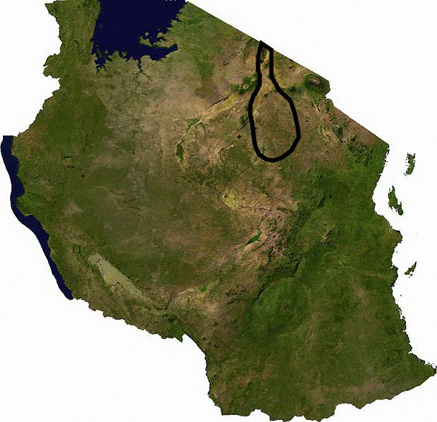
Masai Steppe
Plain · 140,357 km²
Masai Steppe is a plain in Africa, covering an estimated 140,357 km².
The Tarangire Ecosystem () is a geographical region in northern Tanzania, Africa. It extends between 2.5 and 5.5 degrees south latitudes and between 35.5 and 37 degrees east longitudes.
The Tarangire Ecosystem hosts the second-largest population of migratory ungulates in East Africa and the largest population of elephants in northern Tanzania.
The Tarangire Ecosystem is defined by watershed boundaries of the Lake Manyara Basin and the Engaruka Basin, and the long distance migratory movements of eastern white-bearded wildebeest and plains zebra. It includes the dry season wildlife concentration area near the Tarangire River in Tarangire National Park, and the wet-season dispersal and calving grounds to the north in the Northern Plains and to the east in Simanjiro Plains, spanning in total approximately 20,500 km2 (7,900 sq mi). Migratory animals must have access to both the dry-season water source in the park, and the nutrient-rich forage available only on the calving grounds outside the park to successfully raise their calves and maintain their high abundance.
The Tarangire Ecosystem is also known as the Masai Steppe, or the Tarangire-Manyara Ecosystem.
Adapted from Wikipedia: Tarangire Ecosystem (CC BY-SA 4.0).
- Feature class
- Plain
- Mapped extent
- 140,357 km²
- Size rank
- #54 of 231 landforms
- Region
- Africa
- Coordinates
- -5.1148°, 35.6203°
- Summits:
- Loolmalasin (3,682 m), Mount Kilimanjaro (5,895 m), Lesatima (4,001 m)
- Ranges:
- Ruwenzori Range (Africa), Inyanga Mountains (Africa)
More about Masai Steppe
Geography and climate
The area falls within the eastern branch of the East African Rift Valley which has widened and the valley floor fallen over the past few million years. About 250,000 years ago Lake Manyara and Lake Burunge were part of a larger lake called Proto-Manyara, a basin of internal drainage that lost water through evaporation and deep percolation. Subsequent rises in the Rift Valley floor changed drainage patterns and the lake was reduced in size and divided into the two shallow, alkali lakes currently seen. Topography is now mainly low ridges of gneiss and pre-Cambrian rocks covered with well-drained, medium textured, stony soils. Large areas of valley bottoms are montmorillonite black cotton soils. Ancient lake sediments produced clay soils in the Proto-Manyara area.
History
Between the sixteenth and nineteenth centuries, the Maa-speaking pastoral people expanded into the area, replacing other pastoral groups like Nilotes and farming Bantu groups. By 1880 the Maasai reached their greatest extent. Around 1900 they suffered pleuro-pneumonia and smallpox diseases that killed many. At the same time the outbreak of the rinderpest decimated Maasai livestock and wildlife.
The colonial period of 1880s to 1950s saw the displacement of Maasai from lands with high potential for agricultural development by the European farmers/settlers. Many game parks were created at the same time, often evicting pastoralists from key dry season grazing areas and watering points.
Sections adapted from Wikipedia: Tarangire Ecosystem (CC BY-SA 4.0).
