Skip to content
YearMaps
Norway · Islands

Largest Islands of Norway

Svalbard is the largest of the 9 islands recorded for Norway, at 283,881 km², ahead of Spitsbergen at 38,337 km². The full list follows.

How this list is built: Ranked by mapped area. An island divided between countries is listed under each, with the area of the whole island. It covers the islands indexed in YearMaps, drawn from open geospatial data, and is not an exhaustive national register.

Islands Listed
9
Top Ranked
283,881 km²
Svalbard
Second
38,337 km²
Spitsbergen
Profiled Below
9
Photo, encyclopedia text and figures
Largest Islands of Norway
#NameArea
1Svalbard283,881 km²
2Spitsbergen38,337 km²
3Nordaustlandet14,416 km²
4Vesterålen7,918 km²
5Edgeøya5,392 km²
6Jan Mayen455 km²
7Kvitøya244 km²
8Bjørnøya192 km²
9Lofoten75 km²

The Islands of Norway in Detail

The 9 islands above that have an encyclopedia article, in the same order, each with its photograph, figures and the places around it.

Svalbard
Image via Wikimedia Commons (author and licence on the file page).

Svalbard

Island group · 283,881 km²

Svalbard is an island group in Europe (Arctic Ocean), covering an estimated 283,881 km².

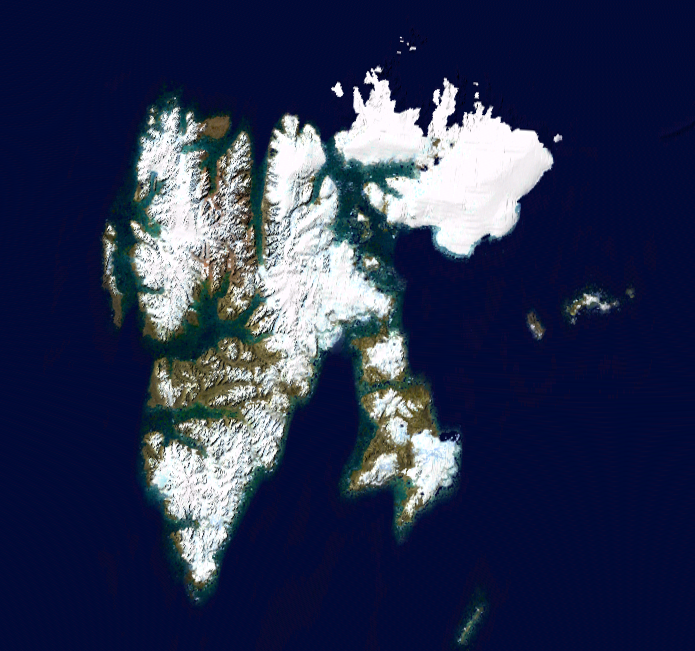
Svalbard (US: SVAHL-bar(d), UK: also SVAL-, Urban East Norwegian: [ˈsvɑ̂ːɫbɑr]), formerly Spitsbergen or Spitzbergen, is a Norwegian archipelago that lies at the convergence of the Arctic Ocean with the Atlantic Ocean. North of mainland Europe, it lies about midway between the northern coast of Norway and the North Pole. The islands of the group range from 74° to 81° north latitude, and from 10° to 35° east longitude. The largest island is Spitsbergen (37,673 km2), followed in size by Nordaustlandet (14,443 km2), Edgeøya (5,073 km2), and Barentsøya (1,288 km2). Bjørnøya or Bear Island (178 km2) is the most southerly island in the territory, situated some 147 km south of Spitsbergen. Other small islands in the group include Hopen to the southeast of Edgeøya, Kongsøya and Svenskøya in the east, and Kvitøya to the northeast. The largest settlement is Longyearbyen, situated in Isfjorden on the west coast of Spitsbergen.

Whalers who sailed far north in the 17th and 18th centuries used the islands as a base; subsequently, the archipelago was abandoned.

Adapted from Wikipedia: Svalbard (CC BY-SA 4.0).

Feature class
Island group
Mapped extent
283,881 km²
Size rank
#30 of 445 islands
Region
Europe
Subregion
Arctic Ocean
Coordinates
76.3908°, 21.2013°
Summits:
Newtontoppen (1,713 m), Haltiatunturi (1,328 m), Kebnekaise (2,111 m)
Ranges:
Ural Mountains (Europe), Grampian Mountains (Europe)
Settlements:
Tromsø (754 km), Narvik (900 km), Severomorsk (904 km)

View on the live map

More about Svalbard

Geography

The Svalbard Treaty of 1920 defines Svalbard as all islands, islets, and skerries from 74° to 81° north latitude, and from 10° to 35° east longitude. The land area is 61,022 km2 (23,561 sq mi), and dominated by the island of Spitsbergen, which constitutes more than half the archipelago, followed by Nordaustlandet and Edgeøya.

All settlements are on Spitsbergen, except the meteorological outposts on Bjørnøya and Hopen. The Norwegian state took possession of all unclaimed land, or 95.2% of the archipelago, at the time the Svalbard Treaty entered into force; Store Norske, a Norwegian coal mining company, owns 4%, Arktikugol, a Russian coal mining company, owns 0.4%, while other private owners hold 0.4%.

History

The Dutchman Willem Barentsz made the first discovery of the archipelago in 1596, when he sighted the coast of the island of Spitsbergen while searching for the Northern Sea Route.

The first recorded landing on the islands of Svalbard dates to 1604, when an English ship landed at Bjørnøya, or Bear Island, and started hunting walrus. Annual expeditions soon followed, and Spitsbergen became a base for hunting the bowhead whale from 1611. Because of the lawless nature of the area, English, Danish, Dutch, and French companies and authorities tried to use force to keep out other countries' fleets.

Smeerenburg was one of the first settlements, established by the Dutch in 1619. Smaller bases were also built by the English, Danish, and French.

Climate

The climate of Svalbard is dominated by its high latitude, with the average daily mean summer temperature at 4 to 7 °C (39 to 45 °F) (1991–2020 averages), and January averages at −13 to −9 °C (9 to 16 °F) (1991–2020). The more southern Bear Island has January mean temperatures as mild as −4.6 °C (24 °F) in the 1991–2020 base period.

The West Spitsbergen Current, the northernmost branch of the North Atlantic Current system, moderates Svalbard's temperatures, particularly during winter. Winter temperatures in Svalbard are up to 20 °C (36 °F) higher than those at similar latitudes in Russia and Canada. The warm Atlantic water keeps the surrounding waters open and navigable most of the year.

Economy

The three main industries on Svalbard are coal mining, tourism, and research. In 2007, there were 484 people working in the mining sector, 211 people working in the tourism sector, and 111 people working in the education sector. The same year, the mining yielded revenues of 2.008 billion Norwegian kroner (US$227,791,078), tourism 317 million kroner (US$35,967,202), and research 142 million kroner (US$16,098,404).

In 2006, the average income for economically active people was 494,700 kroner, 23% higher than on the mainland.

Sections adapted from Wikipedia: Svalbard (CC BY-SA 4.0).

Svalbard: Key Facts

Key facts about Svalbard
Area61,022 km²
Population2,668
Highest pointNewtontoppen
Surrounded byNorwegian Sea

Facts from Wikidata Q25231 (CC0).

Spitsbergen
Image via Wikimedia Commons (author and licence on the file page).

Spitsbergen

Island · 38,337 km²

Spitsbergen is an island in Europe (Arctic Ocean), covering an estimated 38,337 km².

Spitsbergen (Urban East Norwegian: [ˈspɪ̀tsˌbærɡn̩]; formerly known as West Spitsbergen; Norwegian: Vest Spitsbergen or Vestspitsbergen [ˈvɛ̂stˌspɪtsbærɡn̩], also sometimes spelled Spitzbergen) is the largest and the only permanently populated island of the Svalbard archipelago in northern Norway in the Arctic Ocean.

Constituting the westernmost bulk of the archipelago, it borders the Arctic Ocean, the Norwegian Sea and the Greenland Sea. Spitsbergen covers an area of 37,673 km2 (14,546 sq mi), making it the largest island in Norway and the 36th largest in the world. The administrative centre is Longyearbyen. Other settlements, in addition to research outposts, are the mining community of Barentsburg, the research community of Ny-Ålesund, and the mining outpost of Sveagruva. Spitsbergen was covered in 21,977 km2 (8,485 sq mi) of ice in 1999, which was approximately 58.5% of the island's total area.

The island was first used as a whaling base in the 17th and 18th centuries, after which it was abandoned. Coal mining started at the end of the 19th century, and several permanent communities were established.

Adapted from Wikipedia: Spitsbergen (CC BY-SA 4.0).

Feature class
Island
Mapped extent
38,337 km²
Size rank
#90 of 445 islands
Region
Europe
Subregion
Arctic Ocean
Coordinates
78.8328°, 18.3515°
Summits:
Newtontoppen (1,713 m), Haltiatunturi (1,328 m), Beerenberg (2,277 m)
Ranges:
Ural Mountains (Europe), Grampian Mountains (Europe)
Settlements:
Tromsø (1,023 km), Narvik (1,162 km), Severomorsk (1,171 km)

View on the live map

More about Spitsbergen

History

The first recorded sighting of the island was by Willem Barentsz, a Dutch explorer who came across it while searching for the Northern Sea Route in June 1596. The first good map, with the east coast roughly indicated, appeared in 1623, printed by Willem Janszoon Blaeu. Around 1660 and 1728, better maps were produced.

The archipelago may have been known to Russian Pomor hunters as early as the 14th or 15th century, although solid evidence preceding the 17th century is lacking. Following the English whalers and others in referring to the archipelago as Greenland, they named it Grumant (Грумант). The name Svalbard is first mentioned in Icelandic sagas of the 10th and 11th centuries, but this may have been Jan Mayen.

Climate

The climate of Svalbard is dominated by its high latitude, with the average summer temperature at 4 °C (39 °F) to 6 °C (43 °F) and January averages at −12 °C (10 °F) to −16 °C (3 °F). The North Atlantic Current moderates Spitsbergens's temperatures, particularly during winter, giving it up to 20 °C (36 °F) higher winter temperature than similar latitudes in Russia and Canada. This keeps the surrounding waters open and navigable most of the year. The interior fjord areas and valleys, sheltered by the mountains, have larger temperature differences than the coast, giving about 2 °C (4 °F) lower summer temperatures and 3 °C (5 °F) higher winter temperatures. On the south of Spitsbergen, the temperature is slightly higher than further north and west.

Economy

The three main industries on Spitsbergen are coal mining, tourism and research. In 2007, there were 484 people working in the mining sector, 211 people working in the tourism sector and 111 people working in the education sector. The same year, mining produced a revenue of NOK 2,008 million, tourism NOK 317 million and research NOK 142 million. In 2006, the average income for economically active people was NOK 494,700—23% higher than on the mainland. Almost all housing is owned by the various employers and institutions and rented to their employees; there are only a few privately owned houses, most of which are recreational cabins. Because of this, it is almost impossible to live on Spitsbergen without working for an established institution.

Sections adapted from Wikipedia: Spitsbergen (CC BY-SA 4.0).

Spitsbergen: Key Facts

Key facts about Spitsbergen
Area39,044 km²
Population2,642 (2012)
Highest pointNewtontoppen
Surrounded byGreenland Sea

Facts from Wikidata Q21162 (CC0).

Visiting Spitsbergen

Svalbard (Russian: Шпицберген, Shpitsbergen or Грумант, Grumant) is a group of islands located between the Arctic Ocean, Barents Sea, Greenland Sea, and the Norwegian Sea. The area is sometimes referred to as Spitsbergen, the main island with all the settlements. The islands are directly north of Norway, and have been under Norwegian rule since 1920. Svalbard's settlements are the second most northerly permanently-inhabited spots on the planet, after the Canadian military base at Alert.

Svalbard is a unique place because of its nature, the extreme northern location and its legal status as neutral Norwegian territory. There is virtually no infrastructure outside a handful of small settlements. About 60% of the area is covered by glaciers, 30% is barren rock and only 10% is covered by vegetation. Svalbard has midnight sun from late April to late August, while winter darkness (polar night) lasts from late October to February. Seven national parks and 23 nature reserves cover 70% of the islands.

Travel notes adapted from Wikivoyage: Svalbard (CC BY-SA 4.0).

Nordaustlandet
Image via Wikimedia Commons (author and licence on the file page).

Nordaustlandet

Island · 14,416 km²

Nordaustlandet is an island in Europe (Arctic Ocean), covering an estimated 14,416 km².

Nordaustlandet (Anglicised as North East Land) is the second-largest island in the archipelago of Svalbard, Norway, with an area of 14,443 square kilometres (5,576 sq mi). It lies north east of Spitsbergen, separated by Hinlopen Strait. Much of Nordaustlandet lies under large ice caps, mainly Austfonna and Vestfonna, the remaining parts of the north being tundra inhabited by reindeer and walruses. The island is uninhabited and lies entirely within Nordaust-Svalbard Nature Reserve.

Adapted from Wikipedia: Nordaustlandet (CC BY-SA 4.0).

Feature class
Island
Mapped extent
14,416 km²
Size rank
#124 of 445 islands
Region
Europe
Subregion
Arctic Ocean
Coordinates
79.8196°, 24.2538°
Summits:
Newtontoppen (1,713 m), Haltiatunturi (1,328 m), Beerenberg (2,277 m)
Ranges:
Ural Mountains (Europe), Grampian Mountains (Europe)
Settlements:
Tromsø (1,142 km), Severomorsk (1,222 km), Murmansk (1,232 km)

View on the live map

More about Nordaustlandet

History

English walrus hunters first sighted the south point of Nordaustlandet in 1617. This discovery was shown on the Muscovy Company's map (1625; but based on discoveries made in and prior to 1622), with the island labeled as Sir Thomas Smyth's Iland. It also shows the North Cape (Point Purchas). It is first named Oostlandt ("East Land") on a Dutch 1662 map, and the following year another Dutch map marked its coastline more distinctly, showing its west and north coasts, separating the latter from the Seven Islands (Sjuøyane). A Dutch map of 1710 was the first to show the island accurately, naming it Het Noord Ooster Land ("The North-east Land").

During the German occupation of Norway in World War II, eleven German soldiers were sent to Nordaustlandet in August 1944 to report on the weather.

Geology and landscape

The rock types in Nordaustlandet stem from many different geological eras. The northern part consists of old crystalline basement, with rocks such as marble, quartzite, mica schist, gneiss and granite. East of Lady Franklinfjorden, on the peninsula Botniahalvøya and east of Duvefjorden there are volcanic rocks. In the east and south of Rijpfjorden the bedrock is made up of distinctive red-coloured granite. The Rijpfjord granite is medium grained, and contains two micas (muscovite and biotite) in addition to quartz, plagioclase and pink K-feldspar. It was emplaced in late Silurian times.

Layered gabbro and dolerite of Silurian age occur at Kapp Laura in easternmost Nordaustlandet, on the island of Storøya, and in the eastern part of the island of Kvitøya.

Sections adapted from Wikipedia: Nordaustlandet (CC BY-SA 4.0).

Nordaustlandet: Key Facts

Key facts about Nordaustlandet
Area14,467 km²
Population0
Highest pointSnøtoppen
Surrounded byBarents Sea

Facts from Wikidata Q207374 (CC0).

Vesterålen
Image via Wikimedia Commons (author and licence on the file page).

Vesterålen

Island · 7,918 km²

Vesterålen is an island in Europe, covering an estimated 7,918 km².

Vesterålen (English: VEST-ər-aw-lən, Norwegian: [ˈvɛ̂stəroːɫn̩]; Northern Sami: Viestterálas) is a district and archipelago in Nordland county, Norway. It is located just north of Lofoten and west of Harstad. It is the northernmost part of Nordland county. Sortland is the largest town, situated near the center of the archipelago. Vesterålen includes the municipalities of Andøy, Bø, Hadsel, Sortland, and Øksnes.

Adapted from Wikipedia: Vesterålen (CC BY-SA 4.0).

Feature class
Island
Mapped extent
7,918 km²
Size rank
#167 of 445 islands
Region
Europe
Coordinates
68.7972°, 15.5936°
Summits:
Kebnekaise (2,111 m), Haltiatunturi (1,328 m), Oksskolten (1,916 m)
Ranges:
Grampian Mountains (Europe), Harz (Europe)
Settlements:
Narvik (83 km), Tromsø (163 km), Bodø (179 km)

View on the live map

More about Vesterålen

Geography

Vesterålen consists of the municipalities of Andøy, Bø, Hadsel, Sortland, and Øksnes. According to some definitions, Lødingen Municipality is also included. Vesterålen is made up of several islands: Langøya, Andøya, Hadseløya, the western part of Hinnøya, the northern part of Austvågøya and several smaller islands.

The landscape is mountainous, but the mountains have a more rounded shape compared to the mountains in Lofoten. The towns and villages are situated on the strandflat (strandflaten) between the mountains and the fjords. There are also several lakes, such as Alsvågvatnet. Møysalen National Park is partly located in Vesterålen (website). The climate in Vesterålen is maritime, with mild winters considering this archipelago is well north of the Arctic Circle.

Economy

The population in Vesterålen as of 1 January 2004 was 30,648 according to Statistisk Sentralbyrå) The largest town is Sortland, but the regional hospital is in nearby Stokmarknes in Hadsel Municipality. The Royal Norwegian Air Force has based all its P-3 Orion maritime patrol aircraft at Andøya Air Station, and Andøya Rocket Range is also located at Andøya. The Norwegian Coast Guard has its northern base at Sortland (Kystvaktskvadron Nord).

Fishing, in particular cod fisheries, has always been important in Vesterålen. There is also fish farming, and some agriculture in Vesterålen.

Sections adapted from Wikipedia: Vesterålen (CC BY-SA 4.0).

Edgeøya
Image via Wikimedia Commons (author and licence on the file page).

Edgeøya

Island · 5,392 km²

Edgeøya is an island in Europe (Arctic Ocean), covering an estimated 5,392 km².

Edgeøya (Norwegian: [ˈɛdʒˌœ͡ʏɑ]), anglicised as Edge Island, is a Norwegian island located in southeast of the Svalbard archipelago; with an area of 5,073 square kilometres (1,960 sq mi), it is the third-largest island in this archipelago. An Arctic island, it forms part of the Søraust-Svalbard Nature Reserve, home to polar bears and reindeer. An ice field covers its eastern side. The island takes its name from Thomas Edge (died 1624), an English merchant and whaler. It is seldom visited today and development of tourist facilities is forbidden by law because of its nature reserve status.

Adapted from Wikipedia: Edgeøya (CC BY-SA 4.0).

Feature class
Island
Mapped extent
5,392 km²
Size rank
#187 of 445 islands
Region
Europe
Subregion
Arctic Ocean
Coordinates
77.7989°, 22.5730°
Summits:
Newtontoppen (1,713 m), Haltiatunturi (1,328 m), Kebnekaise (2,111 m)
Ranges:
Ural Mountains (Europe), Grampian Mountains (Europe)
Settlements:
Tromsø (914 km), Severomorsk (1,025 km), Murmansk (1,033 km)

View on the live map

More about Edgeøya

Geography and ecology

Edgeøya is located at geographical co-ordinates 77°40′N 22°30′E. To the west lies Storfjorden, which separates Edgeøya from Spitsbergen. To the north, the sound known as Freemansundet lies between Edgeøya and Barentsøya. In the northeast, Olgastretet separates Edgeøya from Kong Karls Land. Minor island groups lay to the east (Ryke Yseøyane) and to the south (Thousand Islands). The island's south coast in indented by its largest fjord, Tjuvfjorden. The island's northernmost point is Kapp Heuglin, a cape named in August 1870 for the German explorer Theodor von Heuglin (1824–76), during the Heuglin-Zeil expedition.

History

The history of Edgeøya's discovery has been a matter of dispute. Thomas Edge, writing in 1622, claimed the island was discovered by one of his ships in 1616. However, Joris Carolus, in a map published in 1614 and allegedly based on discoveries made by him the same year, shows what appears to be Edgeøya's south coast. Carolus showed the coastline split into two parts: "Onbekende Cust" (meaning "Unknown Coast" in Dutch) in the west, and "Morfyn" in the east. Islands are shown offshore of Morfyn. Martin Conway argued in 1901 that Carolus' chart indicated he discovered Edgeøya, but, as Wielder points out, Conway was ignorant of a map (engraved in 1612) by the Dutch cartographer Petrus Plancius, which illustrated a coastline to the east of Spitsbergen.

Sections adapted from Wikipedia: Edgeøya (CC BY-SA 4.0).

Edgeøya: Key Facts

Key facts about Edgeøya
Area5,073 km²
Population0
Surrounded byArctic Ocean

Facts from Wikidata Q695120 (CC0).

Jan Mayen
Image via Wikimedia Commons (author and licence on the file page).

Jan Mayen

Island · 455 km²

Jan Mayen is an island in Europe (Arctic Ocean), covering an estimated 455 km².

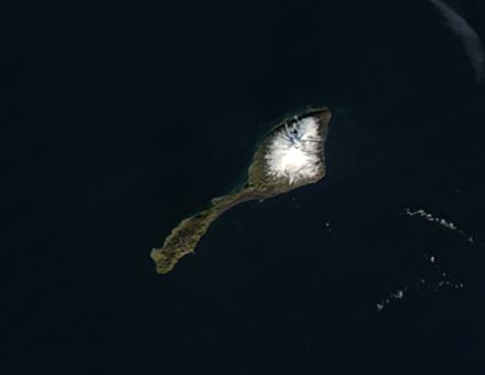
Jan Mayen (Urban East Norwegian: [jɑn ˈmɑ̀ɪən]) is a Norwegian volcanic island in the Arctic Ocean with no permanent population. It is 55 km (34 mi) long (southwest-northeast) and 377 km2 (146 sq mi) in area, partly covered by glaciers (an area of 114.2 km2 (44.1 sq mi) around the Beerenberg volcano). It has two parts: larger northeast Nord-Jan and smaller Sør-Jan, linked by a 2.5 km (1.6 mi) wide isthmus. It lies 600 km (370 mi) northeast of Iceland (495 km [305 mi] NE of Kolbeinsey), 500 km (310 mi) east of central Greenland, and 900 km (560 mi) northwest of Vesterålen, Norway.

The island is mountainous, the highest summit being the Beerenberg volcano in the north. The isthmus is the location of the two largest lakes of the island, Sørlaguna (South Lagoon) and Nordlaguna (North Lagoon). A third lake is called Ullerenglaguna (Ullereng Lagoon). Jan Mayen was formed by the Jan Mayen hotspot and is defined by geologists as a microcontinent.

Although administered separately, in the ISO 3166-1 standard, Jan Mayen and Svalbard are collectively designated as Svalbard and Jan Mayen, with the two-letter country code "SJ". It was also given the Internet domain of .sj.

Adapted from Wikipedia: Jan Mayen (CC BY-SA 4.0).

Feature class
Island
Mapped extent
455 km²
Size rank
#338 of 445 islands
Region
Europe
Subregion
Arctic Ocean
Coordinates
71.0760°, -8.2139°
Summits:
Beerenberg (2,277 m), Gunnbjørn Fjeld (3,694 m), Slaettaratindur (882 m)
Ranges:
Grampian Mountains (Europe), Cambrian Mountains (Europe)
Settlements:
Reykjavík (960 km), Bodø (983 km), Narvik (1,018 km)

View on the live map

More about Jan Mayen

History

The land named Svalbarð ("cold coast") by the Vikings in the early medieval book Landnámabók may have been Jan Mayen (instead of Spitsbergen, renamed Svalbard by the Norwegians in modern times); the distance from Iceland to Svalbarð mentioned in this book is two days' sailing (with favorable winds), consistent with the approximate 550 km (340 mi) to Jan Mayen and not with the minimum 1,550 km (960 mi) to Spitsbergen. However much Jan Mayen may have been known in Europe at that time, it was subsequently forgotten for some centuries.

In the 17th century, many claims of the island's rediscovery were made, spurred by the rivalry on the Arctic whaling grounds, and the island received many names.

Sections adapted from Wikipedia: Jan Mayen (CC BY-SA 4.0).

Jan Mayen: Key Facts

Key facts about Jan Mayen
Area377 km²
Population18 (2010)
Highest pointBeerenberg
Surrounded byArctic Ocean, Greenland Sea

Facts from Wikidata Q14056 (CC0).

Visiting Jan Mayen

Jan Mayen is an island between Greenland and Norway in the Arctic Ocean, administered by Norway. The island has 18 inhabitants, employed by the Norwegian Armed Forces or the Norwegian Institute of Meteorology.

Travel notes adapted from Wikivoyage: Jan Mayen (CC BY-SA 4.0).

Kvitøya
Image via Wikimedia Commons (author and licence on the file page).

Kvitøya

Island · 244 km²

Kvitøya is an island in Europe (Arctic Ocean), covering an estimated 244 km².

Kvitøya (English: "White Island") is an island in the Svalbard archipelago in the Arctic Ocean, with an area of 682 square kilometres (263 sq mi). It is the easternmost part of the Kingdom of Norway. The closest Russian Arctic possession, Victoria Island, lies only 62 kilometres (39 mi) to the east of Kvitøya.

The island is almost completely covered by Kvitøyjøkulen, an ice cap with an area of 705 square kilometres (272 sq mi) with a classical, hourglass-shaped dome, which has given it its name. The few ice-free land areas are each only a few square kilometres large and very barren and rocky, the largest being Andréeneset on the southwest corner of the island. Kvitøya is a part of the Nordaust-Svalbard Nature Reserve.

Kvitøya, along with nearby Abel Island, are the only landmasses under airspace that does not belong to any flight information region.

Adapted from Wikipedia: Kvitøya (CC BY-SA 4.0).

Feature class
Island
Mapped extent
244 km²
Size rank
#365 of 445 islands
Region
Europe
Subregion
Arctic Ocean
Coordinates
80.1615°, 32.7306°
Summits:
Newtontoppen (1,713 m), Haltiatunturi (1,328 m), Kebnekaise (2,111 m)
Ranges:
Ural Mountains (Europe), Grampian Mountains (Europe)
Settlements:
Tromsø (1,228 km), Severomorsk (1,233 km), Murmansk (1,244 km)

View on the live map

More about Kvitøya

History

Kvitøya was discovered by the Dutchman Cornelis Giles in 1707, and it was seen under the name 'Giles Land' or 'Gillis Land' on maps in different shapes, sizes and positions throughout the centuries.

The island was the resting place of Andrée's Arctic balloon expedition of 1897, organised by S. A. Andrée. The expedition had attempted to overfly the North Pole in a hydrogen balloon, but was forced down on the pack ice about 300 kilometres (190 mi) north of Kvitøya on 14 July, less than three days after their launch. They reached the island on foot by 6 October and settled on the only ice free part on the island, on what is now called Andréeneset.

Climate

Kvitøya has a Tundra climate (Köppen: ET), where no month has a mean daily temperature of above 10 °C (50 °F). The climate closely borders on an ice cap climate, with July and August being the only months with a mean daily temperature above freezing.

Sections adapted from Wikipedia: Kvitøya (CC BY-SA 4.0).

Kvitøya: Key Facts

Key facts about Kvitøya
Area682 km²
Population0
Surrounded byArctic Ocean

Facts from Wikidata Q851568 (CC0).

Bjørnøya
Image via Wikimedia Commons (author and licence on the file page).

Bjørnøya

Island · 192 km²

Bjørnøya is an island in Europe, covering an estimated 192 km².

Bear Island (Norwegian: Bjørnøya, pronounced [ˈbjø̀ːɳœʏɑ]) is the southernmost island of the Norwegian Svalbard archipelago. The island is located at the limits of the Norwegian and Barents seas, approximately halfway between Spitsbergen and the North Cape. Bear Island was discovered by Dutch explorers Willem Barentsz and Jacob van Heemskerck on 10 June 1596. It was named after a polar bear that was seen swimming nearby. The island was considered terra nullius until the Spitsbergen Treaty of 1920 placed it under Norwegian sovereignty.

Despite its remote location and barren nature, the island has seen commercial activities in past centuries, such as coal mining, fishing and whaling. However, no settlements have lasted more than a few years, and Bear Island is now uninhabited except for personnel working at the island's meteorological station Bjørnøya radio. Along with the adjacent waters, it was declared a nature reserve in 2002.

Adapted from Wikipedia: Bjørnøya (CC BY-SA 4.0).

Feature class
Island
Mapped extent
192 km²
Size rank
#371 of 445 islands
Region
Europe
Coordinates
74.4569°, 19.0619°
Summits:
Newtontoppen (1,713 m), Haltiatunturi (1,328 m), Kebnekaise (2,111 m)
Ranges:
Ural Mountains (Europe), Grampian Mountains (Europe)
Settlements:
Tromsø (536 km), Narvik (678 km), Severomorsk (776 km)

View on the live map

More about Bjørnøya

Geography

Bear Island lies about 235 kilometres (127 nmi) south of mainland Spitsbergen and 397 kilometres (214 nmi) north-northwest of Ingøy in mainland Norway. It is located at the limits of the Norwegian and Barents Seas on Spitsbergen Bank, which extends southward from Spitsbergen and Edgeøya, forming a part of the continental shelf.

The island's outline is an approximate triangle pointing south with a greatest north–south extension of 20 kilometres (12 mi) and a greatest east-west extension of 15.5 kilometres (9+3⁄4 mi). Its surface area is 178 square kilometres (69 sq mi). The southern part of Bjørnøya is mountainous, the highest top being Miseryfjellet on the southeast coast at about 536 metres (1,759 ft) above sea level.

History

Seafarers of the Viking era may have known Bear Island, but the documented history begins in 1596, when Willem Barentsz sighted the island on his third expedition. He named this island "Vogel Eylandt", "Bird Island" in English. Steven Bennet conducted further exploration in 1603 and 1604 and noted the then rich population of walrus. Starting in the early 17th century, the island was used mainly as a base for the hunting of walrus and other species of seals. Also, the eggs of seabirds were harvested from the large bird colonies until 1971.

The Muscovy Company claimed Bear Island for the English Crown in 1609, but it abandoned the site when walrus-hunting declined.

Sections adapted from Wikipedia: Bjørnøya (CC BY-SA 4.0).

Bjørnøya: Key Facts

Key facts about Bjørnøya
Area178 km²
Population9
Highest pointMiseryfjellet
Surrounded byNorwegian Sea

Facts from Wikidata Q194364 (CC0).

Visiting Bjørnøya

Bear Island, Norwegian Bjørnøya, is an islet in the Arctic Ocean, between Northern Norway and Svalbard. The island has no permanent population, except some meteorology crew.

Travel notes adapted from Wikivoyage: Bear Island (CC BY-SA 4.0).

Lofoten
Image via Wikimedia Commons (author and licence on the file page).

Lofoten

Island · 75 km²

Lofoten is an island in Europe, covering an estimated 75 km².

Lofoten (English: LOH-foh-tən, loh-FOH-tən, Norwegian: [ˈlùːfuːtn̩]; Lule Sami: Lufoahtta; Northern Sami: Lufuohttá) is an archipelago and a traditional district in the county of Nordland, Norway. Lofoten has distinctive scenery with dramatic mountains and peaks, open sea and sheltered bays, beaches, and untouched lands. There are two towns, Svolvær and Leknes — the latter approximately 169 km (105 mi) north of the Arctic Circle and 2,420 km (1,500 mi) from the North Pole. Winter temperatures in the archipelago are extremely mild considering its northerly location – possibly the largest positive temperature anomaly in the world relative to latitude. As of 2017, the islands attract one million tourists each year. Winter tourism has grown significantly, with visitors coming to experience the northern lights and unique Arctic scenery during the polar night season.

Adapted from Wikipedia: Lofoten (CC BY-SA 4.0).

Feature class
Island
Mapped extent
75 km²
Size rank
#430 of 445 islands
Region
Europe
Coordinates
67.8174°, 12.7601°
Summits:
Oksskolten (1,916 m), Kebnekaise (2,111 m), Haltiatunturi (1,328 m)
Ranges:
Grampian Mountains (Europe), Harz (Europe)
Settlements:
Bodø (94 km), Mo i Rana (178 km), Narvik (198 km)

View on the live map

More about Lofoten

Geography

Further to the south are the small and isolated islands of Værøy Municipality (67°40′N 12°40′E) and Røst Municipality (67°37′N 12°7′E). The total land area amounts to 1,227 square kilometres (474 square miles), and the population totals 24,500. Many will argue that Hinnøya, the northern part of Austvågøya and several hundred smaller islands, skerries, and rocks to the east of Austvågøya are also part of the Lofoten district. Historically, the territorial definition of Lofoten has changed significantly. Between the mainland and the Lofoten archipelago lies the vast, open Vestfjorden, and to the north is the Vesterålen district. The principal towns in Lofoten are Leknes in Vestvågøy Municipality and Svolvær in Vågan Municipality.

History

According to Robert M. D'Anjou and others: "There is evidence of human settlement extending back at least 11,000 years in Lofoten, and the earliest archaeological sites... are only about 5,500 years old, at the transition from the early to late Stone Age". Iron Age agriculture, livestock, and significant human habitation can be traced back to c. 250 BC.

The town of Vågan (Old Norse: Vágar) is the first known town formation in northern Norway. It existed in the early Viking Age, maybe earlier, and was located on the southern coast of eastern Lofoten, near today's village Kabelvåg in Vågan Municipality.

Sections adapted from Wikipedia: Lofoten (CC BY-SA 4.0).

Lofoten: Key Facts

Key facts about Lofoten
Area1,227 km²
Highest pointHigravstinden
Surrounded byArctic Ocean

Facts from Wikidata Q186822 (CC0).

Visiting Lofoten

Lofoten is a group of islands in the northern part of Norway. With its postcard-looking small fishing villages nestled in fjords dotting a very rugged coast with abrupt peaks rising directly from the ocean, the archipelago is often described as one of the most scenic parts of Norway.

Travel notes adapted from Wikivoyage: Lofoten (CC BY-SA 4.0).

More on Norway

Quick Answers

What is the largest island in Norway?
Svalbard, at 283,881 km². Spitsbergen is second at 38,337 km². Rankings cover the islands indexed in YearMaps.
How many islands are there in Norway?
YearMaps lists 9 islands for Norway. This is the number mapped in the atlas, not an official national count.