Skip to content
YearMaps
New Zealand · Mountains

Highest Mountains in New Zealand

Aoraki/Mount Cook is the highest of the 5 mountains recorded for New Zealand, at 3,754 m, ahead of Tapuaenuku at 2,885 m. The full list follows.

How this list is built: Ranked by summit elevation above sea level. A summit on a border is listed under both countries. It covers the mountains indexed in YearMaps, drawn from open geospatial data, and is not an exhaustive national register.

Mountains Listed
5
Top Ranked
3,754 m
Aoraki/Mount Cook
Second
2,885 m
Tapuaenuku
Profiled Below
5
Photo, encyclopedia text and figures
Highest Mountains in New Zealand
#NameElevation
1Aoraki/Mount Cook3,754 m
2Tapuaenuku2,885 m
3Mount Ruapehu2,797 m
4Mount Taranaki2,518 m
5Mount Anglem980 m

The Mountains of New Zealand in Detail

The 5 mountains above that have an encyclopedia article, in the same order, each with its photograph, figures and the places around it.

Aoraki/Mount Cook
Image via Wikimedia Commons (author and licence on the file page).

Aoraki/Mount Cook

Mountain · 3,754 m

Aoraki/Mount Cook is a mountain rising to 3,754 metres (12,316 ft) in New Zealand, in the Oceania region.

Aoraki / Mount Cook is the highest mountain in New Zealand. Its height, as of 2014, is listed as 3,724 metres (12,218 feet). It is situated in the Southern Alps, the mountain range that runs the length of the South Island. A popular tourist destination, it is also a favourite challenge for mountaineers. Aoraki / Mount Cook consists of three summits: from south to north, the Low Peak (3,593 m or 11,788 ft), the Middle Peak (3,717 m or 12,195 ft) and the High Peak. The summits lie slightly south and east of the main divide of the Southern Alps, with the Tasman Glacier to the east and the Hooker Glacier to the southwest. Mount Cook is ranked 10th in the world by topographic isolation.

Adapted from Wikipedia: Aoraki / Mount Cook (CC BY-SA 4.0).

Elevation
3,754 m (12,316 ft)
Global rank
#150 of 641 indexed
Region
Oceania (#5)
Subregion
New Zealand
Country
New Zealand
Coordinates
-43.5957°, 170.1411°

Of the 641 named summits indexed in YearMaps, Aoraki/Mount Cook ranks #150 by elevation, below Demirkazik (3,756 m) and above Cerro Nube Flan (3,750 m).

Ranges:
Southern Alps (Oceania), Australian Alps (Oceania)
Neighbouring summits:
Tapuaenuku (2,885 m), Mount Anglem (980 m), Mount Taranaki (2,518 m)
Settlements below:
Timaru (125 km), Christchurch (201 km), Dunedin (256 km)

View on the live map

More about Aoraki/Mount Cook

Geology

The Southern Alps in the South Island were formed by tectonic uplifting and pressure as the Pacific and Indo-Australian Plates collided along the island's western coast. The uplifting continues, raising Aoraki / Mount Cook an average of 7 millimetres (0.28 in) each year. However, erosive forces are also powerful shapers of the mountains. The severe weather is due to the mountain's jutting into powerful westerly winds of the Roaring Forties which run around approximately 45°S latitude, south of both Africa and Australia. The Southern Alps are the first obstacle the winds encounter after South America, having moved east across the Southern Ocean.

Climbing history

The first recorded attempt on the summit was made by the Irishman Rev. William S. Green, the Swiss hotelier Emil Boss, and the Swiss mountain guide Ulrich Kaufmann on 2 March 1882 via the Tasman and Linda Glaciers. They came within a few feet of the top, as did the 1890 ascent attempt by Mannering and Dixon.

The first known ascent was on 25 December 1894, when New Zealanders Tom Fyfe, John Michael (Jack) Clarke and George Graham reached the summit via the Hooker Valley and the north ridge. Despite an earlier failed attempt on 20 December, the local climbers were spurred on by their desire for the first ascent to be made by New Zealand mountaineers amid reports that the American mountaineer Edward FitzGerald had his eye on the summit.

Māori history, legends and traditions

According to Māori legend, Aoraki was a young boy who, along with his three brothers, were the sons of Rakinui, the Sky Father. On their voyage around the Papatūānuku, the Earth Mother, their canoe became stranded on a reef and tilted. Aoraki and his brothers climbed onto the top side of their canoe. However, the south wind froze them and turned them to stone. Their canoe became the Te Waka o Aoraki, the South Island, and their prows, the Marlborough Sounds. Aoraki, the tallest, became the highest peak, and his brothers created the Kā Tiritiri o te Moana, the Southern Alps.

Ngāi Tahu, the main iwi (tribe) of New Zealand's southern region, consider Aoraki as the most sacred of the ancestors that they had descended from.

Local climate

Aoraki / Mount Cook receives substantial orographic precipitation throughout the year, as breezy, moisture-laden westerly winds dominate all year-round, bringing rainclouds from the Tasman Sea with them.

Annual precipitation around the mountain ranges varies greatly as the local climate is dominated by the eastward movement of depressions and anticyclones from across the Tasman Sea. The Aoraki / Mount Cook massif is a major obstacle to the prevailing westerly winds as they push depressions and associated cold fronts of moist air from the subtropics in the northwest against the mountain range. As the air rises towards the peaks, it expands and cools, and forms clouds.

Sections adapted from Wikipedia: Aoraki / Mount Cook (CC BY-SA 4.0).

Aoraki/Mount Cook: Key Facts

Key facts about Aoraki/Mount Cook
Topographic prominence3,724 m
Mountain rangeSouthern Alps / Kā Tiritiri o te Moana

Facts from Wikidata Q5059 (CC0).

Tapuaenuku
Image via Wikimedia Commons (author and licence on the file page).

Tapuaenuku

Mountain · 2,885 m

Tapuaenuku is a mountain rising to 2,885 metres (9,465 ft) in New Zealand, in the Oceania region. From PeakBagger.com, with kind permission..

Tapuae-o-Uenuku, formerly Mount Tapuaenuku, is the highest peak in the northeast of New Zealand's South Island. The name translates from Māori as "footprint of the rainbow", though is usually regarded as being named after Chief Tapuaenuku.

At 2,885 metres (9,465 ft) it is the highest mountain in New Zealand outside the main ranges of the Southern Alps, and over 80 metres taller than Mount Ruapehu, the tallest peak in the North Island. It had its beginnings as a magma chamber 3–4 km below the South Island's Torlesse rocks, which in turn had been buried by a 2 km geological layer over the last 100 million years. It has thus been uplifted almost 9 km over the last 4–5 million years, and without substantial erosion would be taller than the Himalayas.

Tapuae-o-Uenuku dominates the Inland Kaikōura Range, rising high above the valleys of the Waiau Toa / Clarence and Awatere Rivers. It can be seen from as far away as Mount Ruapehu in the North Island, more than 340 km away, and is a prominent point on the horizon for travellers on the interisland ferries that ply Cook Strait.

Adapted from Wikipedia: Tapuae-o-Uenuku (CC BY-SA 4.0).

Elevation
2,885 m (9,465 ft)
Global rank
#263 of 641 indexed
Region
Oceania (#9)
Subregion
New Zealand
Country
New Zealand
Coordinates
-42.0000°, 173.6600°

Of the 641 named summits indexed in YearMaps, Tapuaenuku ranks #263 by elevation, below Pico da Bandeira (2,890 m) and above Maromokotro (2,876 m).

Ranges:
Southern Alps (Oceania), Australian Alps (Oceania)
Neighbouring summits:
Mount Taranaki (2,518 m), Aoraki/Mount Cook (3,754 m), Mount Ruapehu (2,797 m)
Settlements below:
Blenheim (59 km), Nelson (86 km), Wellington (122 km)

View on the live map

More about Tapuaenuku

Tapuaenuku: Key Facts

Key facts about Tapuaenuku
Topographic prominence2,022 m
Mountain rangeKaikōura Ranges

Facts from Wikidata Q6924042 (CC0).

Mount Ruapehu
Image via Wikimedia Commons (author and licence on the file page).

Mount Ruapehu

Mountain · 2,797 m

Mount Ruapehu is a mountain rising to 2,797 metres (9,177 ft) in New Zealand, in the Oceania region.

Mount Ruapehu (Māori: [ˈɾʉaˌpɛhʉ]; English ) is an active stratovolcano at the southern end of the Taupō Volcanic Zone and North Island volcanic plateau in New Zealand. It is 23 km (14 mi) northeast of Ohakune and 23 km (14 mi) southwest of the southern shore of Lake Taupō, within Tongariro National Park. The North Island's major ski resorts and only glaciers are on its slopes.

Ruapehu, the largest active volcano in New Zealand, has the highest point in the North Island and has three major peaks: Tahurangi (2,797 m; 9,177 ft), Te Heuheu (2,755 m; 9,039 ft) and Paretetaitonga (2,751 m; 9,026 ft). The deep, active crater is between the peaks and fills with water between major eruptions, being known as Crater Lake (Māori: Te Wai ā-moe). The name Ruapehu means "pit of noise" or "exploding pit" in Māori.

Adapted from Wikipedia: Mount Ruapehu (CC BY-SA 4.0).

Elevation
2,797 m (9,177 ft)
Global rank
#276 of 641 indexed
Region
Oceania (#10)
Subregion
New Zealand
Country
New Zealand
Coordinates
-39.2833°, 175.5668°

Of the 641 named summits indexed in YearMaps, Mount Ruapehu ranks #276 by elevation, below Pico da Pedra da Mina (2,798 m) and above Cerro Grande (2,780 m).

Ranges:
Southern Alps (Oceania), Australian Alps (Oceania)
Neighbouring summits:
Mount Taranaki (2,518 m), Tapuaenuku (2,885 m), Aoraki/Mount Cook (3,754 m)
Settlements below:
Taupo (79 km), Wanganui (85 km), Hastings (116 km)

View on the live map

More about Mount Ruapehu

Geography

Ruapehu is located in the centre of the North Island of New Zealand, 23 km (14 mi) northeast of Ohakune, New Zealand, and 23 km (14 mi) southwest of the southern shore of Lake Taupō, within Tongariro National Park. Ruapehu is the largest and southernmost volcano in the national park, with an estimated volume of 110 km3 (26 cu mi). The volcano is surrounded by a ring plain of volcanic material, made from lahar deposits, ash fall, and landslide debris.

There are three access routes to Ruapehu, and each access route leads to one of the three skifields that are found on its slopes.

Geology

Ruapehu is a composite andesitic stratovolcano located at the southern end of the Taupō Volcanic Zone and forming part of the Tongariro Volcanic Centre. Volcanism at Ruapehu is caused by the subduction of the Pacific Plate under the Australian Plate at the Hikurangi Trough to the east of the North Island. Ruapehu has erupted from multiple craters over its lifetime, however, only one crater is presently active, a deep crater at the southern end of the summit plateau which is filled with hot, acidic water, dubbed Crater Lake (Te Wai ā-moe). The lake water currently covers separate north and central vents.

Ruapehu sits on a basement of Mesozoic greywacke overlain by a thin layer of sediments of the Wanganui Basin, composed of sands, silts, shell beds, and limestone.

Sections adapted from Wikipedia: Mount Ruapehu (CC BY-SA 4.0).

Mount Ruapehu: Key Facts

Key facts about Mount Ruapehu
Topographic prominence2,797 m
Mountain rangeNorth Island Volcanic Plateau

Facts from Wikidata Q207284 (CC0).

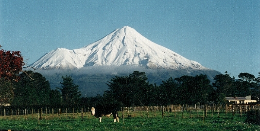
Mount Taranaki
Image via Wikimedia Commons (author and licence on the file page).

Mount Taranaki

Mountain · 2,518 m

Mount Taranaki is a mountain rising to 2,518 metres (8,261 ft) in New Zealand, in the Oceania region.

Mount Taranaki (Māori: Taranaki Maunga), officially Taranaki Maunga and also known as Mount Egmont, is a dormant stratovolcano in the Taranaki region on the west coast of New Zealand's North Island. At 2,518 metres (8,261 ft), it is the second highest mountain in the North Island, after Mount Ruapehu. It has a secondary cone, Fanthams Peak (Māori: Panitahi), 1,966 metres (6,450 ft), on its south side.

Adapted from Wikipedia: Mount Taranaki (CC BY-SA 4.0).

Elevation
2,518 m (8,261 ft)
Global rank
#336 of 641 indexed
Region
Oceania (#12)
Subregion
New Zealand
Country
New Zealand
Coordinates
-39.2963°, 174.0649°

Of the 641 named summits indexed in YearMaps, Mount Taranaki ranks #336 by elevation, below Gora Burun-Shibertuy (2,519 m) and above Kompasberg (2,504 m).

Ranges:
Southern Alps (Oceania), Australian Alps (Oceania)
Neighbouring summits:
Mount Ruapehu (2,797 m), Tapuaenuku (2,885 m), Aoraki/Mount Cook (3,754 m)
Settlements below:
New Plymouth (27 km), Wanganui (109 km), Palmerston North (176 km)

View on the live map

More about Mount Taranaki

Geology

Mount Taranaki is situated in the sedimentary Taranaki Basin and is part of the Taranaki Volcanic Lineament which has had a 3 cm/year (1.2 in/year) north to south migration over the last 1.75 million years. A Wadati–Benioff zone exists at about 200 km (120 mi) depth and the volcano's magma has the geochemical features of an arc volcano. Under the volcano itself there is high heat flow with only about 10 km (6.2 mi) crustal thickness although this rapidly normalises for continental crust to 35 km (22 mi) east of the volcano and 25 km (16 mi) to the west.

History

The mountain was tapu in Māori culture and at the time of European settlement not climbed by them.

In 1839 the mountain was climbed by James Heberley, a whaler who reached the summit first, and the Swiss-trained doctor and naturalist Ernst Dieffenbach. During his initial ascent, he identified the fast-flowing streams as being well suited to water driven mills. Dieffenbach was employed by the New Zealand Company to advise on the potential of land he explored in the North Island in 1839–40.

In 1865 the mountain was confiscated from Māori by the New Zealand Government under the powers of the New Zealand Settlements Act 1863, ostensibly as a means of establishing and maintaining peace amid the Second Taranaki War.

Sections adapted from Wikipedia: Mount Taranaki (CC BY-SA 4.0).

Mount Taranaki: Key Facts

Key facts about Mount Taranaki
Topographic prominence2,308 m

Facts from Wikidata Q850051 (CC0).

Mount Anglem
Image via Wikimedia Commons (author and licence on the file page).

Mount Anglem

Mountain · 980 m

Mount Anglem is a mountain rising to 980 metres (3,215 ft) in New Zealand, in the Oceania region. From PeakBagger.com, with kind permission..

Mount Anglem / Hananui is the highest point on New Zealand's Stewart Island / Rakiura. It is located 20 kilometres (12 mi) northwest of Oban, close to the island's north coast, and rises to an elevation of 980 metres (3,215 ft) above sea level. Following the passage of the Ngāi Tahu Claims Settlement Act 1998, the name of the peak was officially altered to Mount Anglem / Hananui.

Views from Mount Anglem include those inland looking west onto the floodplains. The southern tip of the South Island is visible on a clear day.

Adapted from Wikipedia: Mount Anglem (CC BY-SA 4.0).

Elevation
980 m (3,215 ft)
Global rank
#559 of 641 indexed
Region
Oceania (#39)
Subregion
New Zealand
Country
New Zealand
Coordinates
-46.7401°, 167.9199°

Of the 641 named summits indexed in YearMaps, Mount Anglem ranks #559 by elevation, below Monts de la Lékéti (1,000 m) and above Mont Agou (968 m).

Ranges:
Southern Alps (Oceania), Australian Alps (Oceania)
Neighbouring summits:
Aoraki/Mount Cook (3,754 m), Tapuaenuku (2,885 m), Mount Taranaki (2,518 m)
Settlements below:
Invercargill (50 km), Dunedin (219 km), Timaru (367 km)

View on the live map

More about Mount Anglem

Mount Anglem: Key Facts

Key facts about Mount Anglem
Topographic prominence980 m

Facts from Wikidata Q3070397 (CC0).

More on New Zealand

Quick Answers

What is the highest mountain in New Zealand?
Aoraki/Mount Cook, at 3,754 m. Tapuaenuku is second at 2,885 m. Rankings cover the mountains indexed in YearMaps.
How many mountains are there in New Zealand?
YearMaps lists 5 mountains for New Zealand. This is the number mapped in the atlas, not an official national count.