
Map of Guinea Bissau
Guinea Bissau is a country in Africa with its capital at Bissau, home to about 2.25 million people across 36,125 km². The interactive map below plots 8 cities and towns, 1 rivers and 1 ports recorded for Guinea Bissau in YearMaps.
- Population
- 2.25 million
- Area
- 36,125 km²
- Capital
- Bissau
- Continent
- Africa
Interactive Map of Guinea Bissau
Centred on Bissau at 11.8650° N, 15.5984° W. Use the layer panel to switch on rivers, dams, ports, peaks and historical borders.
About Guinea Bissau
Guinea-Bissau, officially the Republic of Guinea-Bissau, is a country in West Africa that covers 36,125 square kilometres (13,948 sq mi) with an estimated population of 2,080,000. It borders Senegal to its north and Guinea to its southeast.
Guinea-Bissau was once part of the kingdom of Kaabu, as well as part of the Mali Empire. Parts of this kingdom persisted until the 18th century, while a few others had been under some rule by the Portuguese Empire since the 16th century. In the 19th century, it was colonised as Portuguese Guinea. Upon independence, declared in 1973 and recognised in 1974, the name of its capital, Bissau, was added to the country's name to prevent confusion with Guinea (formerly French Guinea).
Guinea-Bissau has had a history of political instability: following the bloody but ultimately successful war of independence, the winning PAIGC established a one-party socialist state, which was under military control from 1984 to 1994, when free multiparty elections were held. Several successful military coups have since interrupted peaceful transfer of power, most recently the 2025 coup, which installed the currently ruling military junta, headed by the transitional president Horta Inta-A Na Man.
About 2% of the population speaks Portuguese, the official language, as a first language, and 33% speak it as a second language. Guinea-Bissau Creole, a Portuguese-based creole, is the national language and also considered the language of unity. According to a 2012 study, 54% of the population speak Creole as a first language and about 40% speak it as a second language. The remainder speak a variety of native African languages. The nation is home to numerous followers of Islam, Christianity, and multiple traditional faiths. The country's GDP per capita is one of the lowest in the world.
Guinea-Bissau is a member of the United Nations, Organisation of Islamic Cooperation, Community of Portuguese Language Countries, Organisation internationale de la Francophonie, Alliance of Small Island States and the South Atlantic Peace and Cooperation Zone. It was also a member of the now-defunct Latin Union. As of November 2025, its membership in Economic Community of West African States and African Union has been suspended after a coup d'etat.
Summary adapted from Wikipedia: Guinea-Bissau (CC BY-SA 4.0).

Geography and Climate of Guinea Bissau
For much of its history, Guinea-Bissau was under the control of the Mali Empire and the Kaabu Kingdom. In the 16th century, Portugal began establishing trading posts along Guinea-Bissau’s shoreline. Initially, the Portuguese were restricted to the coastline and islands. However, the slave and gold trades were lucrative to local African leaders, and the Portuguese were slowly able to expand their power and influence inland. Starting in the 18th century, the Mali Empire and Kingdom of Kaabu slowly disintegrated into smaller local entities. By the 19th century, Portugal had fully incorporated Guinea-Bissau into its empire. Since gaining independence in 1974, Guinea-Bissau has experienced considerable political and military upheaval. In 1980, a military coup established General Joao Bernardo 'Nino' VIEIRA as president. VIEIRA's regime suppressed political opposition and purged political rivals. Several coup attempts through the 1980s and early 1990s failed to unseat him, but a military mutiny and civil war in 1999 led to VIEIRA's ouster. In 2000, a transitional government turned over power to opposition leader Kumba YALA. In 2003, a bloodless military coup overthrew YALA and installed businessman Henrique ROSA as interim president. In 2005, VIEIRA was reelected, pledging to pursue economic development and national reconciliation; he was assassinated in 2009. Malam Bacai SANHA was then elected president, but he passed away in 2012 from a long-term illness. A military coup blocked the second round of the election to replace him, but after mediation from the Economic Community of Western African States, a civilian transitional government assumed power. In 2014, Jose Mario VAZ was elected president in a free and fair election, and in 2019, he became the first president in Guinea-Bissau’s history to complete a full term. Umaro Sissoco EMBALO was elected president in 2019, but he did not take office until 2020 because of a prolonged challenge to the election results.
- Location
- Western Africa, bordering the North Atlantic Ocean, between Guinea and Senegal.
- Climate
- Tropical; generally hot and humid; monsoonal-type rainy season (June to November) with southwesterly winds; dry season (December to May) with northeasterly harmattan winds.
- Terrain
- Mostly low-lying coastal plain with a deeply indented estuarine coastline rising to savanna in east; numerous off-shore islands including the Arquipelago Dos Bijagos consisting of 18 main islands and many small islets.
- Highest point
- Dongol Ronde 277 m.
- Lowest point
- Atlantic Ocean 0 m.
- Coastline
- 350 km.
- Land borders
- Total: 762 km; border countries: Guinea 421 km; Senegal 341 km.
- Natural resources
- Fish, timber, phosphates, bauxite, clay, granite, limestone, unexploited deposits of petroleum.
- Land use
- Agricultural land: 29.9% (2023 est.); arable land: 14.1% (2023 est.); permanent crops: 8.9% (2023 est.); permanent pasture: 6.9% (2023 est.); forest: 75% (2023 est.); other: 0% (2023 est.)
- Natural hazards
- Hot, dry, dusty harmattan haze may reduce visibility during dry season; brush fires.
- Geographic note
- This small country is swampy along its western coast and is low-lying inland.
- Languages
- Portuguese-based Creole, Portuguese (official; largely used as a second or third language), Pular (a Fula language), Mandingo.
- Religions
- Muslim 46.1%, folk religions 30.6%, Christian 18.9%, other or unaffiliated 4.4% (2020 est.)
- Ethnic groups
- Balanta 30%, Fulani 30%, Manjaco 14%, Mandinga 13%, Papel 7%, unspecified smaller ethnic groups 6% (2015 est.)
- Economy
- Extremely poor West African economy; ethnically diverse labor force; increasing government expenditures; slight inflation due to food supply disruptions; major cashew exporter; systemic banking instabilities and corruption; vulnerable to oil price shocks.
From the CIA World Factbook (public domain), archived edition of 2026-01-22. The Factbook is no longer updated, so figures reflect that edition.
Guinea Bissau in Numbers
- Population
- 2.25 million
- GDP
- US$2.5 billion
- GDP per person
- US$1,124
- Life expectancy
- 64.3 years
- Population growth
- 2.16% a year
- Population density
- 78 per km²
- Urban population
- 46.6%
- Surface area
- 36,125 km²
- Forest cover
- 74.8%
- Arable land
- 16.1%
- Access to electricity
- 43.7%
- Internet users
- 29.8%
Indicators from World Bank Open Data (CC BY 4.0). The year under each figure is its reference year.
Guinea Bissau in Depth
History
The ancient history of what is now Guinea-Bissau is poorly understood by historians. The earliest inhabitants were the Jola, Papel, Manjak, Balanta, and Biafada peoples. Later the Mandinka and Fulani migrated into the region in the 13th and 15th centuries respectively. They pushed the earlier inhabitants towards the coast and onto the Bijagos islands.
The Balanta and Jola had weak or non-existent institutions of kingship but emphasised decentralization, with power invested in heads of villages and families. The Mandinka, Fula, Papel, Manjak, and Biafada chiefs were vassals to kings. The customs, rites, and ceremonies varied, but nobles commanded all the major positions, including the judicial system.
Geography
Guinea-Bissau is bordered by Senegal to the north and Guinea to the south and east, with the Atlantic Ocean to its west. It lies mostly between latitudes 11° and 13°N (a small area is south of 11°), and longitudes 11° and 15°W.
At 36,125 square kilometres (13,948 sq mi), the country is larger in size than Belgium.
The highest point is Monte Torin with an elevation of 262 metres (860 ft). Its terrain is mostly low coastal plains with swamps of the Guinean mangroves rising to the Guinean forest–savanna mosaic in the east. Its monsoon-like rainy season alternates with periods of hot, dry harmattan winds blowing from the Sahara. The Bijagós Archipelago, comprising 88 islands and islets, lies off of the mainland.
Economy
Guinea-Bissau's GDP per capita and Human Development Index are among the lowest in the world. More than two-thirds of the population lives below the poverty line. The economy depends mainly on agriculture; fish, cashew nuts, and ground nuts are its major exports.
A long period of political instability has resulted in depressed economic activity, deteriorating social conditions, and increased macroeconomic imbalances. It takes longer on average to register a new business in Guinea-Bissau (233 days or about 33 weeks) than in any other country in the world except Suriname.
Guinea-Bissau has started to show some economic advances after a pact of stability was signed by the main political parties of the country, leading to an IMF-backed structural reform program.
Demographics
According to the 2022 revision of the World Population Prospects, Guinea-Bissau's population was 2,060,721 in 2021, compared to 518,000 in 1950. The proportion of the population below the age of 15 in 2010 was 41.3%, 55.4% were aged between 15 and 65 years of age, while 3.3% were aged 65 years or older.
The population of Guinea-Bissau is ethnically diverse and has many distinct languages, customs, and social structures.
Manjaco and Mancanha, who occupy the central and northern coastal areas.
Most of the remainder are mestiços of mixed Portuguese and African descent.
Sections adapted from Wikipedia: Guinea-Bissau (CC BY-SA 4.0).
Guinea Bissau: Key Facts
| Currency | West African CFA franc |
|---|---|
| Official language | Portuguese |
| Head of state | Manuel Serifo Nhamadjo |
| Head of government | Rui Duarte de Barros |
| Calling code | +245 |
| Internet domain | .gw |
| Highest point | Monte Torin |
| Lowest point | Atlantic Ocean |
| Established | 1974 |
Facts from Wikidata Q1007 (CC0).
History of Guinea Bissau: Empires and States
The atlas records 6 polities whose mapped territory included part of Guinea Bissau, from The Mali Empire in 1415 CE to 2024 CE. They are listed in the order they first appear.
| Polity | Period here | Extent |
|---|---|---|
| The Mali Empire | 1415–1563 CE | Most |
| Kingdom of Portugal | 1885–1910 CE | Most |
| The Portuguese Empire | 1885–1910 CE | Most |
| Portuguese Republic | 1911–1925 CE | Most |
| Estado Novo | 1926–1975 CE | Most |
| Republic of Guinea-Bissau | 1973–2024 CE | Most |
Historical Maps of Guinea Bissau
Guinea Bissau on the world map in each year one of these states held it:
Derived by testing mapped cities against dated territorial polygons. Dates are when the polygons cover this place, not the polity's whole lifespan, and polities absent from the source dataset are not listed.
Visiting Guinea Bissau
Guinea-Bissau is an off-the-beaten-path destination on the west coast of Africa. It is primarily an agricultural and fishing country of just over 2 million people (2023). This former Portuguese colony is one of the poorest countries in the world. Most tourists come to visit the Bijagós (Bissagos) Archipelago, said to be the most beautiful islands in Africa.
Travel notes adapted from Wikivoyage: Guinea-Bissau (CC BY-SA 4.0).
Largest Cities in Guinea Bissau
8 cities recorded. Ranked by metropolitan population. A port city's harbour is written up on the page of its sea.
| # | Name | Population | Region | Role |
|---|---|---|---|---|
| 1 | Bissau | 403,339 | Bissau | National capital |
| 2 | Bafatá | 29,704 | Bafatá | Admin-1 capital |
| 3 | Gabú | 14,430 | Gabú | Admin-1 capital |
| 4 | Bolama | 10,769 | Bolama | Admin-1 capital |
| 5 | Cacheu | 10,490 | Cacheu | Admin-1 capital |
| 6 | Catió | 9,898 | Tombali | Admin-1 capital |
| 7 | Farim | 6,792 | Oio | Admin-1 capital |
| 8 | Fulacunda | 1,311 | Quinara | Admin-1 capital |
Rivers in Guinea Bissau
1 river recorded. Listed alphabetically. A river is listed where its mapped reach lies, so long rivers appear under more than one country.
| Name | Type | Also Flows Through |
|---|---|---|
| Gêba | River | Guinea |
Ports in Guinea Bissau
1 port recorded. Ranked by approach channel depth, the figure that limits which ships can call. Harbours link to their write-up on the page of the sea or coast they lie on.
| # | Name | Channel Depth | Class | Sea | Max Vessel |
|---|---|---|---|---|---|
| 1 | Bissau | 34.7 m | Very Small | Atlantic Coast of Africa | large vessels |
UNESCO World Heritage Sites in Guinea Bissau
1 World Heritage Site recorded. Listed by year of inscription, earliest first. Sites shared with another country appear under each.
| # | Name | Inscribed | Type | Criteria |
|---|---|---|---|---|
| 1 | Bijagos Archipelago Biosphere Reserve | 2025 | Natural | (ix) (x) |
Largest Islands of Guinea Bissau
1 island recorded. Ranked by mapped area. An island divided between countries is listed under each, with the area of the whole island.
| # | Name | Area | Type |
|---|---|---|---|
| 1 | Arquipélago dos Bijagós | 959 km² | Island group |

Arquipélago dos Bijagós
Island group · 959 km²
Arquipélago dos Bijagós is an island group in Africa, covering an estimated 959 km².
The Bijagós Islands (Portuguese: Arquipélago dos Bijagós), often misspelled Bijagos in English text and formerly known in English as Bissagots (often misspelled Bissagos), are a group of about 88 islands and islets located in the Atlantic Ocean off the coast of Guinea-Bissau.
Adapted from Wikipedia: Bijagós Islands (CC BY-SA 4.0).
- Feature class
- Island group
- Mapped extent
- 959 km²
- Size rank
- #301 of 445 islands
- Region
- Africa
- Coordinates
- 11.4890°, -16.4304°
- Summits:
- Loma Mansa (1,945 m), Mount Wuteve (1,380 m), Mount Richard-Molard (1,752 m)
- Ranges:
- Loma Mountains (Africa), Guinea Highlands (Africa)
- Settlements:
- Bissau (100 km), Ziguinchor (123 km), Brikama (201 km)
More about Arquipélago dos Bijagós
Geography
The archipelago was formed from the ancient delta of the Geba and Grande de Buba rivers and spans an area of 12,958 km2 (5,003 sq mi). Twenty of its islands are populated year-round, including the most populated island, Bubaque. The administrative capital, Bolama is situated on the island of Bolama.
There is a high diversity of ecosystems: mangroves with intertidal zones, palm forests, dry and semi-dry forests, secondary and degraded forests, coastal savanna, sand banks and aquatic zones. The archipelago was declared a UNESCO Biosphere Reserve in 1996.
History
In pre-European colonial times, the islands were central to the trade along the coast of West Africa and they built up a powerful navy. In 1532, King Joao III of Portugal ceded a nominal right to the islands to his brother Luis, Duke of Beja as well as generous trading rights. In 1535, Dom Luis sent a force to conquer the islands, but the islanders' strong navy destroyed it, leaving few survivors. For years afterwards the Bijagós refused to trade with the Portuguese and treated any shipwrecked sailors harshly, until relations were restored around 1550. The Bissago islanders then became important providers of slaves to the Portuguese, putting aside inter-island rivalries to raid the mainland.
Economy
The economy is largely rural, with many families living from subsistence farming and fishing. There is some tourist activity, mostly boat charters from neighboring Senegal. Lack of infrastructure and communication links prevent the development of the islands' tourism potential. Starting in the early 2000s, several of the islands began to be used as transit depots for narcotraffic, which is quickly changing the social and economic fabric of the islands.
Sections adapted from Wikipedia: Bijagós Islands (CC BY-SA 4.0).
Arquipélago dos Bijagós: Key Facts
| Area | 2,624 km² |
|---|---|
| Surrounded by | Atlantic Ocean |
Facts from Wikidata Q664687 (CC0).
Mountain Ranges, Deserts and Landforms of Guinea Bissau
1 landform recorded. Ranked by mapped area. Covers mountain ranges, deserts, plateaus, named glaciers, plains, basins, peninsulas and capes. One that crosses a border is listed under every country it lies in, with the area of the whole feature.
| # | Name | Area | Type | Region |
|---|---|---|---|---|
| 1 | Niger Delta | 431 km² | Delta | Africa |
Niger Delta
Delta · 431 km²
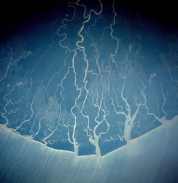
Niger Delta is a delta in Africa, covering an estimated 431 km². It extends across Nigeria, Guinea Bissau, Benin, Mali and Niger.
The Niger Delta is a distinct geographic, ecological, and cultural region situated in southern Nigeria, defined by the extensive floodplain and riverine network where the Niger River drains into the Gulf of Guinea on the Atlantic Ocean [1]. Characterized by a unique aquatic ecosystem of mangrove swamps, barrier islands, and saltwater creeks, the true Niger Delta is home to indigenous populations fundamentally shaped by water and bound by shared cultural traditions. These include a lifestyle centered around riverine occupations, a distinct culinary identity featuring local staples like plantain and periwinkle, and the universal use of Nigerian Pidgin as a lingua franca.
Historically referred to by European traders as the Oil Rivers due to its pre-colonial prominence in the palm oil trade, the maritime area formed the British Oil Rivers Protectorate from 1885 until 1893, when it was reorganized as the Niger Coast Protectorate. In the modern era, the delta has become a globally recognized petroleum-rich hub, serving as the core of international concern over extensive oil pollution and ecological degradation frequently characterized as ecocide.
Adapted from Wikipedia: Niger Delta (CC BY-SA 4.0).
- Feature class
- Delta
- Mapped extent
- 431 km²
- Size rank
- #191 of 231 landforms
- Region
- Africa
- Countries
- Nigeria, Guinea Bissau, Benin, Mali, Niger
- Coordinates
- 4.3147°, 6.2635°
- Ranges:
- Guinea Highlands (Africa), Loma Mountains (Africa)
More about Niger Delta
Geography and Boundaries
A sharp distinction exists between the natural, cultural Niger Delta and the administrative boundaries utilized by the Nigerian federal government. Geographically and ecologically, the authentic Niger Delta does not conform to modern state lines; it spans a continuous, water-bound coastal belt running from the riverine fringes of western Ondo State (such as the Arogbo kingdom) through the southern coastal tip of Edo State, encompassing roughly two-thirds of Delta State, the entirety of Bayelsa State, the riverine southern halves of Rivers State and Akwa Ibom State, and terminating at the southern maritime border of Cross River State at Bakassi.
History
During the pre-colonial and early colonial eras, the maritime delta operated as a vital commercial arena for the palm oil trade and earlier transatlantic exchanges. The British Empire established the Oil Rivers Protectorate in 1885, later expanding it into the Niger Coast Protectorate in 1893.
Following the amalgamation of Nigeria, the core riverine Niger Delta was administratively placed within the former Eastern Region in 1951. During the late colonial transition, minority ethnic groups within the delta's coastal divisions expressed deep political anxieties regarding marginalisation by larger interior ethnic groups.
Sections adapted from Wikipedia: Niger Delta (CC BY-SA 4.0).
Countries Bordering Guinea Bissau
Land and maritime neighbours.
More Maps in Africa
Guinea Bissau: Quick Answers
- What is the capital of Guinea Bissau?
- The capital of Guinea Bissau is Bissau.
- What is the population of Guinea Bissau?
- Guinea Bissau has a population of about 2.25 million, the #148 largest of 225 countries in YearMaps. Source: World Bank, 2025.
- How big is Guinea Bissau?
- Guinea Bissau covers 36,125 km², ranking #140 by area, with about 62 people per square kilometre.
- Which continent is Guinea Bissau in?
- Guinea Bissau is in Africa.
- Which countries border Guinea Bissau?
- Guinea Bissau shares a land or maritime border with Guinea, Senegal.
- What is the largest city in Guinea Bissau?
- Bissau is the largest city in Guinea Bissau, with a metropolitan population of about 403,339.