Skip to content
YearMaps
Antarctica · Mountains

Highest Mountains in Antarctica

Vinson Massif is the highest of the 22 mountains recorded for Antarctica, at 4,892 m, ahead of Mount Kirkpatrick at 4,528 m. The full list follows.

How this list is built: Ranked by summit elevation above sea level. A summit on a border is listed under both countries. It covers the mountains indexed in YearMaps, drawn from open geospatial data, and is not an exhaustive national register.

Mountains Listed
22
Top Ranked
4,892 m
Vinson Massif
Second
4,528 m
Mount Kirkpatrick
Profiled Below
13
Photo, encyclopedia text and figures
Highest Mountains in Antarctica
#NameElevation
1Vinson Massif4,892 m
2Mount Kirkpatrick4,528 m
3Mount Sidley4,285 m
4Mount Kaplan4,230 m
5Mount Minto4,166 m
6Dome A (Argus)4,093 m
7Mount Fridtjof Nansen4,069 m
8Cape Colbeck4,069 m
9Mount Lister4,023 m
10Faure Peak3,940 m
11Fuji Station (Japan)3,810 m
12Mount Erebus3,795 m
13Vostok Station (Rus.)3,488 m
14Mount Takahe3,460 m
15Isachsen Mountain3,425 m
16Concordia Station (Fr. and It.)3,233 m
17Mount Andrew Jackson3,184 m
18Kyrkjeskipet Pk3,085 m
19Mount Seelig3,022 m
20Mount McMaster2,830 m
21Anderson Summit2,810 m
22England Pk2,150 m

The Mountains of Antarctica in Detail

The 13 mountains above that have an encyclopedia article, in the same order, each with its photograph, figures and the places around it.

Vinson Massif
Image via Wikimedia Commons (author and licence on the file page).

Vinson Massif

Mountain · 4,892 m

Vinson Massif is a mountain rising to 4,892 metres (16,050 ft) in Antarctica, in the Antarctica region.

Vinson Massif () is a large mountain massif in Antarctica that is 21 km (13 mi) long and 13 km (8 mi) wide and lies within the Sentinel Range of the Ellsworth Mountains. It overlooks the Ronne Ice Shelf near the base of the Antarctic Peninsula. The massif is located about 1,200 kilometers (750 mi) from the South Pole. Vinson Massif was discovered in January 1958 by U.S. Navy aircraft. In 1961, the Vinson Massif was named by the Advisory Committee on Antarctic Names (US-ACAN), after Carl G. Vinson, United States congressman from the state of Georgia, for his support for Antarctic exploration. On 1 November 2006, US-ACAN declared Mount Vinson and Vinson Massif to be separate entities. Vinson Massif lies within the unrecognized Chilean claim under the Antarctic Treaty System.

Mount Vinson is the highest peak in Antarctica, at 4,892 meters (16,050 ft). It lies in the north part of Vinson Massif's summit plateau in the south portion of the main ridge of the Sentinel Range about 2 kilometers (1+1⁄4 mi) north of Hollister Peak. It was first climbed in 1966 by an American team led by Nicholas Clinch.

Adapted from Wikipedia: Vinson Massif (CC BY-SA 4.0).

Elevation
4,892 m (16,050 ft)
Global rank
#65 of 641 indexed
Region
Antarctica (#1)
Country
Antarctica
Coordinates
-78.5294°, -85.6337°

Of the 641 named summits indexed in YearMaps, Vinson Massif ranks #65 by elevation, below Pik Talghar (4,979 m) and above Puncak Jaya (4,884 m).

Ranges:
Ellsworth Mountains (Antarctica), Jones Mountains (Antarctica)
Neighbouring summits:
Mount Seelig (3,022 m), Mount Takahe (3,460 m), Anderson Summit (2,810 m)
Settlements below:
Ushuaia (2,721 km), Rio Grande (2,836 km), Punta Arenas (2,878 km)

View on the live map

More about Vinson Massif

Geography

The Vinson Massif extends between Goodge Col and Branscomb Glacier to the northwest, Nimitz Glacier and Gildea Glacier to the southwest and south, and Dater Glacier and its tributary Hinkley Glacier to the east. The southeastern part of the massif ends at Hammer Col, which joins it to the Craddock Massif, of which the highest point is Mount Rutford (4,477 metres or 14,688 feet). The massif comprises both the high central Vinson Plateau with its few peaks rising to over 4,700 metres or 15,420 feet, and several side ridges mostly trending southwest or northeast from the plateau.

Geology

Steeply inclined strata known as the Crashsite Group forms Vinson Massif. It consists of 3,000 metres or 9,843 feet of shallow-water, mostly marine, tan, green, and red quartzose sandstones (quartzites) and argillites. In ascending order, the Crashsite Group is subdivided into the Howard Nunataks Formation (1,630 metres or 5,348 feet), the Mount Liptak Formation (1,070 metres or 3,510 feet), and the Mount Wyatt Earp Formation (300 meters or 980 feet). Erosion-resistant and steeply inclined beds of the Mount Wyatt Earp Formation comprise the crest of the Vinson Massif, including Mount Vinson. The steeply inclined strata of the Crashsite Group are part of the western limb of a major syncline that forms the core of the Sentinel Range within the Ellsworth Mountains.

History

A high mountain, provisionally known as "Vinson", was long suspected to be in this part of West Antarctica, but it was not actually seen until January 1958, when it was spotted by US Navy aircraft from Byrd Station. It was named after Carl Vinson, a United States Representative from Georgia who was a key supporter of funding for Antarctic research. The first measurement of the Vinson Massif was established in 1959 at the elevation of 5,140 m (16,864 ft).

In 1963, two groups within the American Alpine Club (AAC), one led by Charles D. Hollister and Samuel C. Silverstein, M.D., then in New York, and the other led by Peter Schoening of Seattle, Washington, began lobbying the National Science Foundation to support an expedition to climb Mount Vinson.

Climate and glaciers

The climate on Mount Vinson is generally controlled by the polar ice cap's high-pressure system, creating predominantly stable conditions but, as in any polar climate, high winds and snowfall are a possibility. Though the annual snowfall on Mount Vinson is low, high winds can cause base camp accumulations up to 46 centimetres (18 in) in a year. During the summer season, November through January, there are 24 hours of sunlight. While the average temperature during these months is −30 °C (−20 °F), the intense sun will melt snow on dark objects.

Over successive years, the limited amount of snow that falls on Vinson Massif compacts and is transformed into ice, forming glaciers.

Sections adapted from Wikipedia: Vinson Massif (CC BY-SA 4.0).

Vinson Massif: Key Facts

Key facts about Vinson Massif
Topographic prominence4,892 m
Mountain rangeSentinel Range

Facts from Wikidata Q163758 (CC0).

Mount Kirkpatrick

Mountain · 4,528 m

Mount Kirkpatrick is a mountain rising to 4,528 metres (14,856 ft) in Antarctica, in the Antarctica region.

Mount Kirkpatrick (84°20′S 166°25′E) is a lofty, generally ice-free mountain in Queen Alexandra Range 5 nautical miles (9.3 km; 5.8 mi) west of Mount Dickerson .

At 4,528 metres (14,856 ft) it is the highest point in the Queen Alexandra Range, Antarctica.

Adapted from Wikipedia: Mount Kirkpatrick (CC BY-SA 4.0).

Elevation
4,528 m (14,856 ft)
Global rank
#77 of 641 indexed
Region
Antarctica (#2)
Country
Antarctica
Coordinates
-84.3396°, 166.4504°

Of the 641 named summits indexed in YearMaps, Mount Kirkpatrick ranks #77 by elevation, below Ras Dejen (4,533 m) and above Volcan Karisimbi (4,519 m).

Ranges:
Queen Alexandra Range (Antarctica), Prince Albert Mountains (Antarctica)
Neighbouring summits:
Mount Kaplan (4,230 m), Mount Fridtjof Nansen (4,069 m), Faure Peak (3,940 m)
Settlements below:
Invercargill (4,218 km), Dunedin (4,278 km), Ushuaia (4,305 km)

View on the live map

More about Mount Kirkpatrick

Location

Mount Kirkpatrick is in the central Queen Alexandra Range to the south of Grindley Plateau, north of the Adams Mountains and northeast of the Marshall Mountains.

Prebble Glacier forms on its west slopes and flows west to Lennox-King Glacier.

Martin Ridge extends southwest from Decennial Peak to the head of Berwick Glacier.

Sections adapted from Wikipedia: Mount Kirkpatrick (CC BY-SA 4.0).

Mount Kirkpatrick: Key Facts

Key facts about Mount Kirkpatrick
Topographic prominence2,601 m
Mountain rangeQueen Alexandra Range

Facts from Wikidata Q1929197 (CC0).

Mount Sidley
Image via Wikimedia Commons (author and licence on the file page).

Mount Sidley

Mountain · 4,285 m

Mount Sidley is a mountain rising to 4,285 metres (14,058 ft) in Antarctica, in the Antarctica region.

Mount Sidley is the highest dormant volcano in Antarctica, and a member of the Volcanic Seven Summits (the highest volcanoes on each of the seven continents) with a summit elevation of 4,181–4,285 metres (13,717–14,058 ft). It is a massive, mainly snow-covered shield volcano, and the highest of the five volcanoes that comprise the Executive Committee Range of Marie Byrd Land. The feature is marked by a 5-kilometre-wide (3.1 mi) caldera on the southern side and stands northeast of Mount Waesche in the southern part of the range.

Adapted from Wikipedia: Mount Sidley (CC BY-SA 4.0).

Elevation
4,285 m (14,058 ft)
Global rank
#100 of 641 indexed
Region
Antarctica (#3)
Country
Antarctica
Coordinates
-77.0316°, -126.0665°

Of the 641 named summits indexed in YearMaps, Mount Sidley ranks #100 by elevation, below Mount Batu (4,307 m) and above Volcán Galeras (4,276 m).

Ranges:
Executive Committee Range (Antarctica), Flood Range (Antarctica)
Neighbouring summits:
Mount Takahe (3,460 m), Mount Seelig (3,022 m), Vinson Massif (4,892 m)
Settlements below:
Ushuaia (3,346 km), Punta Arenas (3,451 km), Rio Grande (3,464 km)

View on the live map

More about Mount Sidley

History

The mountain was discovered by Rear Admiral Richard E. Byrd on an airplane flight, on November 18, 1934, and named by him for Mabelle E. Sidley, the daughter of William Horlick who was a contributor to the 1933–1935 Byrd Antarctic Expedition. Despite its height, the volcano's extremely remote location means that it is little known even in the mountaineering world compared to the much more accessible Mount Erebus, the second-highest Antarctic volcano, which is located near the U.S. and New Zealand bases on Ross Island.

The first recorded ascent of Mount Sidley was by New Zealander Bill Atkinson on January 11, 1990, whilst working in support of a United States Antarctic Program scientific field party.

Sections adapted from Wikipedia: Mount Sidley (CC BY-SA 4.0).

Mount Sidley: Key Facts

Key facts about Mount Sidley
Topographic prominence2,517 m
Mountain rangeExecutive Committee Range

Facts from Wikidata Q924312 (CC0).

Mount Kaplan

Mountain · 4,230 m

Mount Kaplan is a mountain rising to 4,230 metres (13,878 ft) in Antarctica, in the Antarctica region. From PeakBagger.com, with kind permission..

The Hughes Range (84°30′S 175°30′E) is a high massive north–south trending mountain range in Antarctica, surmounted by six prominent summits, of which Mount Kaplan at 4,230 metres (13,880 ft) is the highest. The range is located east of Canyon Glacier in the Queen Maud Mountains and extends 45 nautical miles (83 km; 52 mi) from the confluence of Brandau Glacier and Keltie Glacier in the south, to the Giovinco Ice Piedmont in the north.

Adapted from Wikipedia: Hughes Range (Antarctica) (CC BY-SA 4.0).

Elevation
4,230 m (13,878 ft)
Global rank
#105 of 641 indexed
Region
Antarctica (#4)
Country
Antarctica
Coordinates
-84.5600°, 175.3600°

Of the 641 named summits indexed in YearMaps, Mount Kaplan ranks #105 by elevation, below Munkh Khairkhan (4,231 m) and above Volcán Tajumulco (4,220 m).

Ranges:
Queen Alexandra Range (Antarctica), Prince Albert Mountains (Antarctica)
Neighbouring summits:
Mount Kirkpatrick (4,528 m), Mount Fridtjof Nansen (4,069 m), Faure Peak (3,940 m)
Settlements below:
Ushuaia (4,214 km), Invercargill (4,247 km), Dunedin (4,303 km)

View on the live map

More about Mount Kaplan

Location

The Hughes Range runs southwest–northeast to the Giovinco Ice Piedmont on the Ross Ice Shelf.

It is separated from the Commonwealth Range and the Separation Range to the west by the Keltie Glacier, Pain Névé and Canyon Glacier. The Brandau Glacier and Muck Glacier define the southern boundary. The Barton Mountains and Bush Mountains are to their south.

The Shanklin Glacier and the Ramsey Glacier define the east side of the range.

Features of the Hughes Range, from south to north, include Ford Spur, Haynes Table, Campbell Cliffs and Mount Odishaw to the south of Pain Névé. Above Pain Névé are Mount Kaplan, Mount Wexler and Mount Weterman.

To the east, Mount Valinski is south of the Millington Glacier, a tributary of the Ramsey Glacier.

Sections adapted from Wikipedia: Hughes Range (Antarctica) (CC BY-SA 4.0).

Mount Kaplan: Key Facts

Key facts about Mount Kaplan
Mountain rangeQueen Maud Mountains

Facts from Wikidata Q5933404 (CC0).

Mount Fridtjof Nansen
Image via Wikimedia Commons (author and licence on the file page).

Mount Fridtjof Nansen

Mountain · 4,069 m

Mount Fridtjof Nansen is a mountain rising to 4,069 metres (13,350 ft) in Antarctica, in the Antarctica region.

The Herbert Range (85°22′S 165°30′W) is a range in the Queen Maud Mountains of Antarctica, extending from the edge of the Antarctic Plateau to the Ross Ice Shelf between the Axel Heiberg Glacier and Strom Glacier.

Named by the New Zealand Antarctic Place-Names Committee (NZ-APC) for Walter W. Herbert, leader of the Southern Party of the New Zealand GSAE (1961–62) which explored the Axel Heiberg Glacier area.

Adapted from Wikipedia: Herbert Range (CC BY-SA 4.0).

Elevation
4,069 m (13,350 ft)
Global rank
#117 of 641 indexed
Region
Antarctica (#7)
Country
Antarctica
Coordinates
-85.3476°, -167.5547°

Of the 641 named summits indexed in YearMaps, Mount Fridtjof Nansen ranks #117 by elevation, below Aragats Lerr (4,090 m) and above Cape Colbeck (4,069 m).

Ranges:
Queen Alexandra Range (Antarctica), Ford Ranges (Antarctica)
Neighbouring summits:
Mount Kaplan (4,230 m), Mount Kirkpatrick (4,528 m), Faure Peak (3,940 m)
Settlements below:
Ushuaia (4,027 km), Rio Grande (4,142 km), Punta Arenas (4,183 km)

View on the live map

More about Mount Fridtjof Nansen

Mount Fridtjof Nansen: Key Facts

Key facts about Mount Fridtjof Nansen
Mountain rangeQueen Maud Mountains

Facts from Wikidata Q1234296 (CC0).

Mount Lister
Image via Wikimedia Commons (author and licence on the file page).

Mount Lister

Mountain · 4,023 m

Mount Lister is a mountain rising to 4,023 metres (13,199 ft) in Antarctica, in the Antarctica region. From PeakBagger.com, with kind permission..

Mount Lister (78°04′S 162°41′E) is a massive mountain, 4,025 metres (13,205 ft) high, forming the highest point in the Royal Society Range of Victoria Land, Antarctica.

It was discovered by the British National Antarctic Expedition (1901–1904) which named it for Lord Joseph Lister, President of the Royal Society, 1895–1900.

Adapted from Wikipedia: Mount Lister (CC BY-SA 4.0).

Elevation
4,023 m (13,199 ft)
Global rank
#124 of 641 indexed
Region
Antarctica (#9)
Country
Antarctica
Coordinates
-78.0600°, 162.6898°

Of the 641 named summits indexed in YearMaps, Mount Lister ranks #124 by elevation, below Mount Victoria (4,038 m) and above Mount Waddington (4,019 m).

Ranges:
Prince Albert Mountains (Antarctica), Queen Alexandra Range (Antarctica)
Neighbouring summits:
Mount Erebus (3,795 m), Mount Kirkpatrick (4,528 m), Mount Kaplan (4,230 m)
Settlements below:
Invercargill (3,528 km), Dunedin (3,594 km), Timaru (3,762 km)

View on the live map

More about Mount Lister

Location

Mount Lister is in central Royal Society Range, the highest point on the main north–south ridge that includes The Pimple and Chaplains Tableland to the north and Mount Hooker, Salient Peak and Mount Rücker to the south.

Emmanuel Glacier and its tributary Carleton Glacier run north along the east side of the ridge to Ferrar Glacier.

Howchin Glacier flows southeast from the ridge system towards Koettlitz Glacier, while Salient Glacier, Hooker Glacier and Lister Glacier flow northeast into Blue Glacier.

Sections adapted from Wikipedia: Mount Lister (CC BY-SA 4.0).

Mount Lister: Key Facts

Key facts about Mount Lister
Topographic prominence2,325 m
Mountain rangeRoyal Society Range

Facts from Wikidata Q3861688 (CC0).

Faure Peak

Mountain · 3,940 m

Faure Peak is a mountain rising to 3,940 metres (12,927 ft) in Antarctica, in the Antarctica region. From PeakBagger.com, with kind permission..

The Wisconsin Range (85°45′S 125°00′W) is a major mountain range of the Horlick Mountains in Antarctica, comprising the Wisconsin Plateau and numerous glaciers, ridges and peaks bounded by the Reedy Glacier, Shimizu Ice Stream, Horlick Ice Stream and the interior ice plateau.

Adapted from Wikipedia: Wisconsin Range (CC BY-SA 4.0).

Elevation
3,940 m (12,927 ft)
Global rank
#134 of 641 indexed
Region
Antarctica (#10)
Country
Antarctica
Coordinates
-85.7100°, -128.6300°

Of the 641 named summits indexed in YearMaps, Faure Peak ranks #134 by elevation, below Kuh-e Taftan (3,941 m) and above Kackar Dagi (3,931 m).

Ranges:
Queen Alexandra Range (Antarctica), Pensacola Mountains (Antarctica)
Neighbouring summits:
Mount Fridtjof Nansen (4,069 m), Anderson Summit (2,810 m), Mount Seelig (3,022 m)
Settlements below:
Ushuaia (3,699 km), Rio Grande (3,814 km), Punta Arenas (3,859 km)

View on the live map

More about Faure Peak

Location

The Wisconsin Range is east of the Reedy Glacier and south of the Horlick Ice Stream and the Shimizu Ice Stream. The Wisconsin Plateau is in the southeast of the range.

The southeast of the range borders the west of the Wisconsin Plateau and overlooks the Olentangy Glacier.

From south to north it includes Polygon Spur, Tillite Spur, Red Spur and Mount Huckaby.

The southern massif lies between Olentangy Glacier and Norfolk Glacier both tributaries of the Reedy Glacier.

It includes Mount McNaughton, Mount Bolton, Goodwin Peak, Haworth Mesa and Sisco Mesa.

Sections adapted from Wikipedia: Wisconsin Range (CC BY-SA 4.0).

Faure Peak: Key Facts

Key facts about Faure Peak
Mountain rangeHorlick Mountains

Facts from Wikidata Q8027254 (CC0).

Mount Erebus
Image via Wikimedia Commons (author and licence on the file page).

Mount Erebus

Mountain · 3,795 m

Mount Erebus is a mountain rising to 3,795 metres (12,451 ft) in Antarctica, in the Antarctica region.

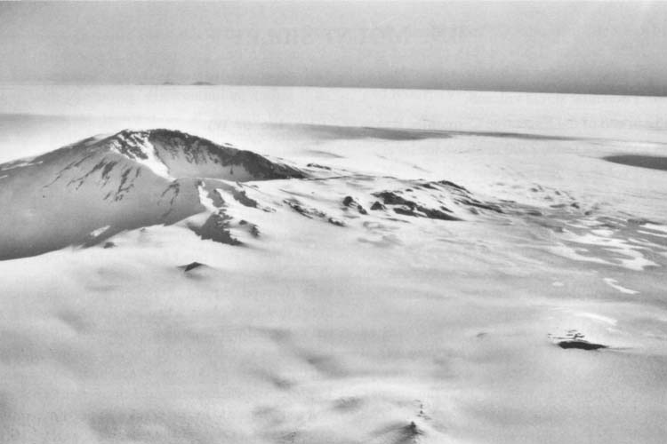
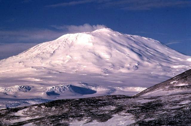
Mount Erebus () is the southernmost active volcano on Earth, located on Ross Island in the Ross Dependency in Antarctica. With a summit elevation of 3,792 metres (12,441 ft), it is the second most prominent mountain in Antarctica (after Mount Vinson) and the second-highest volcano in Antarctica (after the dormant Mount Sidley). It is the highest point on Ross Island, which is also home to three inactive volcanoes: Mount Terror, Mount Bird, and Mount Terra Nova. It makes Ross Island the sixth-highest island on Earth by highest point.

The mountain was named by Captain James Clark Ross in 1841 for his ship, HMS Erebus. The volcano has been active for around 1.3 million years and has a long-lived lava lake in its inner summit crater that has been present since at least the early 1970s. On 28 November 1979, Air New Zealand Flight 901 crashed on Mount Erebus, killing all 257 people on board.

Adapted from Wikipedia: Mount Erebus (CC BY-SA 4.0).

Elevation
3,795 m (12,451 ft)
Global rank
#145 of 641 indexed
Region
Antarctica (#12)
Country
Antarctica
Coordinates
-77.5145°, 167.1829°

Of the 641 named summits indexed in YearMaps, Mount Erebus ranks #145 by elevation, below Grossglockner (3,798 m) and above Fuji (3,776 m).

Ranges:
Prince Albert Mountains (Antarctica), Admiralty Mountains (Antarctica)
Neighbouring summits:
Mount Lister (4,023 m), Mount Kirkpatrick (4,528 m), Mount Kaplan (4,230 m)
Settlements below:
Invercargill (3,459 km), Dunedin (3,520 km), Timaru (3,687 km)

View on the live map

More about Mount Erebus

Geology and volcanology

Mount Erebus is the world's southernmost active volcano. It is the current eruptive centre of the Erebus hotspot. The summit contains a persistent convecting phonolitic lava lake, one of five long-lasting lava lakes on Earth. Characteristic eruptive activity consists of Strombolian eruptions from the lava lake or from one of several subsidiary vents, all within the volcano's inner crater. The volcano is scientifically remarkable in that its relatively low-level and unusually persistent eruptive activity enables long-term volcanological study of a Strombolian eruptive system very close (hundreds of metres) to the active vents, a characteristic shared with only a few volcanoes on Earth, such as Stromboli in Italy.

History

Mount Erebus was discovered on 27 January 1841 (and observed to be in eruption), by polar explorer Sir James Clark Ross on his Antarctic expedition, who named it and its companion, Mount Terror, after his ships, HMS Erebus and HMS Terror (which were later used and lost by Sir John Franklin on his disastrous Arctic expedition). Present with Ross on HMS Erebus was the young Joseph Hooker, future president of the Royal Society and close friend of Charles Darwin. Erebus is a dark region in Hades in Greek mythology, personified as the Ancient Greek primordial deity of darkness, the son of Chaos.

Upper “Summit Camp” site (HSM 89) consists of part of a circle of rocks, which were probably used to weight the tent valances.

Sections adapted from Wikipedia: Mount Erebus (CC BY-SA 4.0).

Mount Erebus: Key Facts

Key facts about Mount Erebus
Topographic prominence3,794 m
Mountain rangeTransantarctic Mountains

Facts from Wikidata Q188982 (CC0).

Mount Takahe
Image via Wikimedia Commons (author and licence on the file page).

Mount Takahe

Mountain · 3,460 m

Mount Takahe is a mountain rising to 3,460 metres (11,352 ft) in Antarctica, in the Antarctica region.

Mount Takahe is a 3,460-metre-high (11,350 ft) snow-covered shield volcano in Marie Byrd Land, Antarctica, 200 kilometres (120 mi) from the Amundsen Sea. It is a c. 30-kilometre-wide (19 mi) mountain with parasitic vents and a caldera up to 8 kilometres (5 mi) wide. Most of the volcano is formed by trachytic lava flows, but hyaloclastite is also found. Snow, ice, and glaciers cover most of Mount Takahe. With a volume of 780 km3 (200 mi3), it is a massive volcano; the parts of the edifice that are buried underneath the West Antarctic Ice Sheet are probably even larger. It is part of the West Antarctic Rift System along with 18 other known volcanoes.

The volcano was active in the Quaternary period. Radiometric dating has yielded ages of up to 300,000 years for its rocks, and it reached its present height about 200,000 years ago. Several tephra layers encountered in ice cores at Mount Waesche and Byrd Station have been attributed to Mount Takahe, although some of them were later linked to eruptions of Mount Berlin instead. The tephra layers were formed by explosive or phreatomagmatic eruptions.

Adapted from Wikipedia: Mount Takahe (CC BY-SA 4.0).

Elevation
3,460 m (11,352 ft)
Global rank
#177 of 641 indexed
Region
Antarctica (#14)
Country
Antarctica
Coordinates
-76.2729°, -112.0999°

Of the 641 named summits indexed in YearMaps, Mount Takahe ranks #177 by elevation, below Volcán Barú (3,475 m) and above Koryakskaya Sopka (3,456 m).

Ranges:
Executive Committee Range (Antarctica), Flood Range (Antarctica)
Neighbouring summits:
Mount Sidley (4,285 m), Vinson Massif (4,892 m), Mount Seelig (3,022 m)
Settlements below:
Ushuaia (2,982 km), Punta Arenas (3,091 km), Rio Grande (3,099 km)

View on the live map

More about Mount Takahe

Geography and geomorphology

The mountain's name refers to the takahē, a flightless and nearly extinct bird from New Zealand; members of the 1957–1958 Marie Byrd Land Traverse party nicknamed an aircraft that had resupplied them "takahe". It was first visited in 1957–1958 and again in 1968, 1984–1985 and 1998–1999. A seismic station was installed on Mount Takahe before January 2019.

Mount Takahe is at the Bakutis Coast, eastern Marie Byrd Land, Antarctica. Bear Peninsula and the Amundsen Sea coast are 200 kilometres (120 mi) north of Mount Takahe. It is an isolated mountain, and the closest other volcanoes are Mount Murphy 100 kilometres (62 mi) and Toney Mountain 140 kilometres (87 mi) away.

Geology

The West Antarctic Rift System is a basin and range province similar to the Great Basin in North America; it cuts across Antarctica from the Ross Sea to the Bellingshausen Sea. The Rift became active during the Mesozoic. Owing to thick ice cover it is not clear whether it is currently active, and there is no seismic activity. Most of the Rift lies below sea level. To the south it is flanked by the Transantarctic Mountains and to the north by the volcanic province of Marie Byrd Land. Volcanic activity in Marie Byrd Land commenced about 34 million years ago, but high activity began 14 million years ago. A major uplifted dome, 1,200 by 500 kilometres (750 mi × 310 mi) in width, is centred on the Amundsen Sea coast and is associated with the Rift.

Eruption history

The volcano was active in the late Quaternary. Radiometric results reported in 1988 include ages of less than 360,000 years for rocks in the caldera rim and of less than 240,000 years for volcanic rocks on the flanks. In his 1990 book Volcanoes of the Antarctic Plate and Southern Oceans LeMasurier gave 310,000±90,000 years ago as the oldest date for samples tested, citing unpublished K-Ar dates, but in a 2016 review of dates for Mount Takahe LeMasurier reported that none were older than 192,000 years. A 2013 paper also by LeMasurier reported maximum ages of 192,000 years for caldera rim rocks and of 66,000 years for lower flank rocks. The entire volcano may have formed in less than 400,000 years or even less than 200,000 years, which would imply rapid growth of the edifice.

Sections adapted from Wikipedia: Mount Takahe (CC BY-SA 4.0).

Mount Takahe: Key Facts

Key facts about Mount Takahe
Topographic prominence2,144 m

Facts from Wikidata Q358755 (CC0).

Isachsen Mountain

Mountain · 3,425 m

Isachsen Mountain is a mountain rising to 3,425 metres (11,237 ft) in Antarctica, in the Antarctica region. From PeakBagger.com, with kind permission..

The Sør Rondane Mountains are a group of mountains about 100 miles (160 km) long with main peaks rising to 3400 m, between the Queen Fabiola Mountains and Wohlthat Mountains in Queen Maud Land. They were discovered and photographed from the air by members of the Lars Christensen Expedition (LCE) on February 6, 1937, and named after Rondane, a mountain massif in southern Norway. The mountains and their constituent features were mapped in greater detail and named in 1957 by Norwegian cartographers working with air photos taken by U.S. Navy Operation Highjump, 1946–47.

Adapted from Wikipedia: Sør Rondane Mountains (CC BY-SA 4.0).

Elevation
3,425 m (11,237 ft)
Global rank
#184 of 641 indexed
Region
Antarctica (#15)
Country
Antarctica
Coordinates
-72.1300°, 26.0800°

Of the 641 named summits indexed in YearMaps, Isachsen Mountain ranks #184 by elevation, below Mount Hood (3,426 m) and above Argun (3,418 m).

Ranges:
Prince Charles Mountains (Antarctica), Napier Mountains (Antarctica)
Neighbouring summits:
Mount McMaster (2,830 m), Olavtoppen (780 m), Anderson Summit (2,810 m)
Settlements below:
Hermanus (4,213 km), Knysna (4,240 km), Port Elizabeth (4,244 km)

View on the live map

Mount Seelig

Mountain · 3,022 m

Mount Seelig is a mountain rising to 3,022 metres (9,915 ft) in Antarctica, in the Antarctica region. From PeakBagger.com, with kind permission..

The Whitmore Mountains (82°35′S 104°30′W) are an isolated mountain range of the Transantarctic Mountains System, located in the Marie Byrd Land region of West Antarctica.

They consist of three mountains and a cluster of nunataks extending over 15 miles. The group was visited and surveyed on January 2, 1959, by William H. Chapman, cartographer with the Horlick Mountains Traverse Party (1958–59). The mountains were named by Chapman for George D. Whitmore, Chief Topographic Engineer of the United States Geological Survey (USGS), who was a member of the Working Group on Cartography of the Scientific Committee on Antarctic Research.

Adapted from Wikipedia: Whitmore Mountains (CC BY-SA 4.0).

Elevation
3,022 m (9,915 ft)
Global rank
#227 of 641 indexed
Region
Antarctica (#19)
Country
Antarctica
Coordinates
-82.4701°, -103.9000°

Of the 641 named summits indexed in YearMaps, Mount Seelig ranks #227 by elevation, below Ulysses Mountain (3,024 m) and above Soira (3,018 m).

Ranges:
Ellsworth Mountains (Antarctica), Pensacola Mountains (Antarctica)
Neighbouring summits:
Anderson Summit (2,810 m), Faure Peak (3,940 m), Vinson Massif (4,892 m)
Settlements below:
Ushuaia (3,266 km), Rio Grande (3,382 km), Punta Arenas (3,420 km)

View on the live map

Mount McMaster
Image via Wikimedia Commons (author and licence on the file page).

Mount McMaster

Mountain · 2,830 m

Mount McMaster is a mountain rising to 2,830 metres (9,285 ft) in Antarctica, in the Antarctica region.

Mount McMaster is an outcrop 861.5 metres (2,800 ft) above sea level, located about 74 km (40 nmi) northeast of Mount Pardoe and 97 km (52 nmi) west of Mount Elkins in Enderby Land, East Antarctica. The outcrop was named after A. McMaster, a surveyor with the Australian National Antarctic Research Expeditions Enderby Land Survey Party in 1976 who established a survey station on the summit.

Adapted from Wikipedia: Mount McMaster (CC BY-SA 4.0).

Elevation
2,830 m (9,285 ft)
Global rank
#269 of 641 indexed
Region
Antarctica (#20)
Country
Antarctica
Coordinates
-66.7635°, 51.9521°

Of the 641 named summits indexed in YearMaps, Mount McMaster ranks #269 by elevation, below Cerro Marahuaca (2,832 m) and above Phou Bia (2,830 m).

Ranges:
Napier Mountains (Antarctica), Prince Charles Mountains (Antarctica)
Neighbouring summits:
Isachsen Mountain (3,425 m), Olavtoppen (780 m), Mount Kirkpatrick (4,528 m)
Settlements below:
Port Elizabeth (4,029 km), Uitenhage (4,057 km), Grahamstown (4,075 km)

View on the live map

Anderson Summit

Mountain · 2,810 m

Anderson Summit is a mountain rising to 2,810 metres (9,219 ft) in Antarctica, in the Antarctica region. From PeakBagger.com, with kind permission..

Ford Massif (85°5′S 91°0′W) is a broad, snow-topped massif 15 nautical miles (28 km; 17 mi) long and 5 nautical miles (9.3 km; 5.8 mi) wide, forming the major topographic landmark of the northern Thiel Mountains in Antarctica. The massif rises to 2,810 metres (9,220 ft), is essentially flat, and terminates in steep rock cliffs in all but the southern side.

Adapted from Wikipedia: Ford Massif (CC BY-SA 4.0).

Elevation
2,810 m (9,219 ft)
Global rank
#274 of 641 indexed
Region
Antarctica (#21)
Country
Antarctica
Coordinates
-85.0398°, -90.8500°

Of the 641 named summits indexed in YearMaps, Anderson Summit ranks #274 by elevation, below Jabal ash Shaykh (2,814 m) and above Pico da Pedra da Mina (2,798 m).

Ranges:
Pensacola Mountains (Antarctica), Ellsworth Mountains (Antarctica)
Neighbouring summits:
Mount Seelig (3,022 m), Faure Peak (3,940 m), Mount Fridtjof Nansen (4,069 m)
Settlements below:
Ushuaia (3,411 km), Rio Grande (3,525 km), Punta Arenas (3,582 km)

View on the live map

More about Anderson Summit

Location

The Ford Massif is the northern past of the Thiel Mountains, separated from the Bermel Escarpment by the Counts Icefall.

Gray Spur is in the southeast of the massif, separated by the Aaron Glacier from Janulis Spur to its north.

Hamilton Cliff defines the northeast face of the massif, below Hadley peak to its west.

Features to the west of Hadley Peak include Compton Valley, Reed Ridge, Streitenberger Cliff and the Johnson Nunataks.

Sections adapted from Wikipedia: Ford Massif (CC BY-SA 4.0).

Anderson Summit: Key Facts

Key facts about Anderson Summit
Mountain rangeThiel Mountains

Facts from Wikidata Q5467845 (CC0).

More on Antarctica

Quick Answers

What is the highest mountain in Antarctica?
Vinson Massif, at 4,892 m. Mount Kirkpatrick is second at 4,528 m. Rankings cover the mountains indexed in YearMaps.
How many mountains are there in Antarctica?
YearMaps lists 22 mountains for Antarctica. This is the number mapped in the atlas, not an official national count.