
Jacques Cartier’s First Voyage (1534)
In 1534 Francis I sent the Breton pilot Jacques Cartier to look for a passage to Asia and for gold. In twenty days Cartier crossed to Newfoundland, passed through the Strait of Belle Isle and charted much of the Gulf of St. Lawrence. At Gaspé he raised a cross claiming the land for France and took two sons of the Iroquoian chief Donnacona back to France.
9,898 km mapped10 stops138 days (about 5 months)
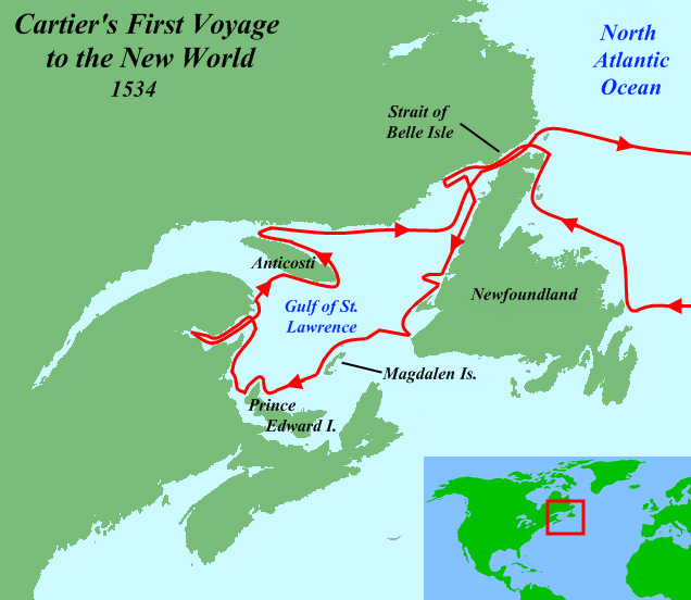
Route Map of Cartier’s first voyage
- Route from recorded positions
- 1Numbered stop (see the itinerary)
- Ship on the map: carrack with castles fore and aft (Age of Discovery), sailing as a fleet of 2
Lines are drawn by YearMaps between the recorded stops, kept at sea around Natural Earth coastlines. They show the order and general track of the voyage, not the exact course steered. How the maps are made.
About Cartier’s first voyage
Jacques Cartier (Breton: Jakez Karter; 31 December 1491 – 1 September 1557) was a French maritime explorer from Brittany. Jacques Cartier was the first European to describe and map the Gulf of Saint Lawrence and the shores of the Saint Lawrence River, which he named "Canada" after the Iroquoian names for the two big settlements he saw at Stadacona (Quebec City) and at Hochelaga (Montreal Island).
Jacques Cartier, author of now-lost maps and accounts of his voyages, was the first European to describe and name this region and its inhabitants—at a time when the Spanish had already settled in the Caribbean, Mexico, and Central America, and were beginning their conquest of Peru.
From Wikipedia: Jacques Cartier (CC BY-SA 4.0).
Itinerary: 10 Stops
In order of the voyage. Numbers match the map; select a stop to show it there.
Saint-Malo
DepartureTwo ships leave the Breton port.
Cape Bonavista, Newfoundland
LandfallA crossing of only twenty days, but the coast is still blocked by ice.
Strait of Belle Isle
PassageCartier calls the barren north shore "the land God gave to Cain".
Magdalen Islands
LandfallIslands full of walrus and seabirds.
Prince Edward Island
LandfallCartier admires the fertile land but takes it for part of the mainland.
Chaleur Bay
PassageMi’kmaq traders meet the ships with furs on sticks. Cartier hopes the bay is a passage west.
Gaspé Bay
EventCartier raises a 30-foot cross claiming the land for France and takes Domagaya and Taignoagny, sons of Donnacona.
Anticosti Island
PassageStrong currents and contrary winds stop Cartier short of the river mouth.
Strait of Belle Isle
PassageThe ships start home.
Saint-Malo
ArrivalCartier is back in time to plan a second voyage the next year.
Sources: Cartier’s Relation, via Wikipedia: Jacques Cartier.
Jacques Cartier’s First Voyage in Depth
First voyage (1534)
In 1534, two years after the Duchy of Brittany was formally united with the French crown in the Edict of Union, Cartier was introduced to King Francis I by Jean Le Veneur, bishop of Saint-Malo and abbot of Mont Saint-Michel, at the Manoir de Brion. The King had previously invited (although not formally commissioned) the Florentine explorer Giovanni da Verrazzano to explore the eastern coast of North America on behalf of France in 1524. Le Veneur cited voyages to Newfoundland and Brazil as proof of Cartier's ability to "lead ships to the discovery of new lands in the New World".
On 20 April 1534, Cartier set sail under a commission from the king, hoping to discover a western passage to the wealthy markets of the East Indies. In the words of the commission, he was to "discover certain islands and lands where it is said that a great quantity of gold and other precious things are to be found".
It took him twenty days to sail across the ocean. Starting on 10 May of that year, he explored parts of Newfoundland, the Strait of Belle Isle and southern shore of the Labrador Peninsula, the Gaspé and North Shore coastlines on the Gulf of St. Lawrence, and some parts of the coasts of the Gulf's main islands, including Prince Edward Island, Anticosti Island and the Magdalen Islands. During one stop at Îles aux Oiseaux (Islands of the Birds, now the Rochers-aux-Oiseaux federal bird sanctuary, northeast of Brion Island in the Magdalen Islands), his crew slaughtered around 1000 birds, most of them great auks (extinct since 1852). Cartier's first two encounters with aboriginal peoples in Canada on the north side of Chaleur Bay, most likely the Mi'kmaq, were brief; some trading occurred.
His third encounter took place on the shores of Gaspé Bay with a party of St. Lawrence Iroquoians, where on 24 July he planted a cross to claim the land for France. The 10-metre cross bearing the words "Long Live the King of France" claimed possession of the territory in the King's name. The change in mood was a clear indication that the Iroquoians understood Cartier's actions. Here he kidnapped the two sons of their chief, Donnacona. Cartier wrote that they later told him this region where they were captured (Gaspé) was called by them Honguedo. The natives' chief at last agreed that they could be taken, under the condition that they return with European goods to trade.
Cartier returned to France in September 1534, sure that he had reached an Asian land.
Sections adapted from Wikipedia: Jacques Cartier (CC BY-SA 4.0).
Pictures of Cartier’s first voyage
23 images from Wikimedia Commons. Select one to enlarge it.
Manicouagan, Baie-Trinité (Village Municipality), Pointe-des-Monts (Hamlet), maritime section or Gulf of the St. Lawrence River, Wednesday, August 4, 2004.Nichole Ouellette/ouellette001.com Camera location49° 19′ 32.1″ N, 67° 22′ 02.3″ W View this and other nearby images on: OpenStreetMap 49.325573; -67.367292 · CC BY 4.0 · Commons SaintmaloUnknown author · CC BY-SA 3.0 · Commons Aerial image of Saint-Malo (view from the south)Carsten Steger · CC BY-SA 4.0 · Commons Gaspé, Quebec, CanadaHayden Soloviev · CC BY 4.0 · Commons Location of Gaspé, Quebec within La Côte-de-Gaspé Regional County Municipality.Gordalmighty · CC BY-SA 3.0 · Commons Map of the Magdalen Islands.Klaus Mueller · CC BY-SA 2.5 · Commons Postcard of butter sculpture tableau of the meeting of Jacques Cartier and Donnacona, Franco-British Exhibition, London, 1908. Sponsored by the Canadian Dairy Association.Unknown authorUnknown author · Public domain · Commons Itinero de la unua ekspedicio de Jacques Cartier en 1534The original uploader was Bartrez at Esperanto Wikipedia. · CC BY-SA 4.0 · Commons Projet d'affiche avant la lettre, de la soirée de gala au casino de Saint-Malo pour l'inauguration de la statue de Jacques Cartier. Tirage imprimé issu d'un dessin-pastel d’Émile Malo-RenaultMalo-Renault · Public domain · Commons A painting representing a side picture of explorer Jacques Cartier, produced by the painter Auguste Lemoine (1895). There are no known paintings of Cartier that were created during his lifetime.Auguste Lemoine / After François Nicholas Riss · Public domain · Commons A painting representing a side picture of explorer Jacques Cartier, produced by the painter Auguste Lemoine (1895). There are no known paintings of Cartier that were created during his lifetime.Auguste Lemoine · Public domain · Commons Avenue Jacques Cartier street sign, Saint-HerblainAdam Bishop · CC BY-SA 3.0 · Commons Title: Canadeense historische scène: Aankomst van Jacques Cartier te Quebec 1535 Format original: breedte 89 mm (geheel) hoogte 140 mm (geheel) Type: ansichtkaart Category: uit de museumcollecties van MASUnknown authorUnknown author · CC0 · Commons Title: Cartier ascending the St. Lawrence Abstract/medium: 1 print : lithograph.Miscellaneous Items in High Demand, PPOC, Library of Congress · Public domain · Commons Carte du premier voyage de Jacques Cartier en 1534.Pierre cb · CC BY-SA 3.0 · Commons Cartier explored what are now known as Newfoundland, the Magdalen Islands, Prince Edward Island and the Gaspé Peninsula on his first voyage in 1534Henri Julien · Public domain · Commons Η αναμνηστική πλάκα για τον Καρτιέ στο Μον-Σαιν-ΜισέλTtzavaras (el:Χρήστης:Ttzavaras) · CC BY-SA 3.0 gr · Commons Map of Jacques Cartier's second voyage to North America in 1535-6.Pierre cb · CC BY-SA 3.0 · Commons Map of Jacques Cartier's second voyage to North America in 1535-6.Jon Platek · CC BY-SA 3.0 · Commons Codex canadensis Jacques CartierLouis Nicolas (1634 - ca. 1682) · Public domain · Commons Arrival of Jacques Cartier at Stadacona, 1535.Walter Baker (1859–1912) · Public domain · Commons Dauphin Map of Canada - circa 1543 - Project Gutenberg etext 20110Unknown author · Public domain · Commons Dauphin Map of Canada - circa 1543 - Showing Jacques Cartier's discoveries. Project Gutenberg eText 20110Project Gutenberg eText 20110 · Public domain · Commons
Frequently Asked Questions
How long did Cartier’s first voyage take?
It lasted 138 days (about 5 months), from 20 April 1534 to 5 September 1534.
How far did Cartier’s first voyage travel?
The route as mapped here, through all 10 stops, is about 9,898 km (5,344 nautical miles). It follows the recorded stops at sea and is a reconstruction, so the true distance sailed was longer.
Who led Cartier’s first voyage?
Jacques Cartier, sponsored by Kingdom of France (Francis I).
What ship was used on Cartier’s first voyage?
Two ships of about 60 tons.
Where did Cartier’s first voyage start and end?
It started at Saint-Malo (20 April 1534) and ended at Saint-Malo (5 September 1534).
What did Cartier’s first voyage achieve?
Gulf of St. Lawrence explored; France’s claim to Canada begun with a cross raised at Gaspé.