
Ottawa
Ottawa is a mapped river in the YearMaps hydrographic index. River courses organise settlement, agriculture and frontier-making more durably than any political boundary, and this reach is indexed against the dams, lakes and cities within its catchment.
- Feature Class
- River
- Coordinates
- 45.89°, -76.82°
About Ottawa
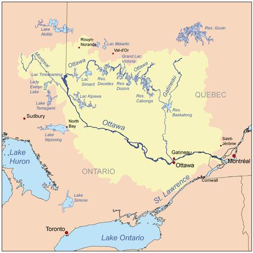
The Ottawa River (French: Rivière des Outaouais, Algonquin: Kichi-Sìbì/Kitchissippi) is a river in the Canadian provinces of Ontario and Quebec. It is named after the Algonquin word "to trade", as it was the major trade route of Eastern Canada at the time. For most of its length, it defines the border between these two provinces. It is a major tributary of the St. Lawrence River and the longest river in Quebec.
Encyclopedic summary adapted from Wikipedia: Ottawa River (CC BY-SA 4.0).
Ottawa in Depth
Geography
The river rises at Lac des Outaouais, north of the Laurentian Mountains of central Quebec, and flows west to Lake Timiskaming. From there its route has been used to define the interprovincial border with Ontario.
From Lake Timiskaming, the river flows southeast to Ottawa and Gatineau, where it tumbles over Chaudière Falls and further takes in the Rideau and Gatineau rivers.
The Ottawa River drains into the Lake of Two Mountains and the St. Lawrence River at Montreal. The river is 1,271 km (790 mi) long; it drains an area of 146,300 km2 (56,500 sq mi), 65 per cent in Quebec and the rest in Ontario, with a mean discharge of 1,950 m3/s (69,000 cu ft/s). It has a maximum depth of 90 m (300 ft) at the Carillon Reservoir and is 7,400 m (24,300 ft) wide at its widest part.
History
As it does to this day, the river played a vital role in life of the Algonquin people, who lived throughout its watershed at contact. The river is called Kichisìpi, meaning "Great River" in Anicinàbemowin, the Algonquin language. The Algonquin define themselves in terms of their position on the river, referring to themselves as the Omàmiwinini, 'down-river people'. Although a majority of the Algonquin First Nation lives in Quebec, the entire Ottawa Valley is Algonquin traditional territory. Present settlement is a result of adaptations made as a result of settler pressures.
Geology
The Ottawa River lies in the Ottawa-Bonnechere Graben, which is a Mesozoic rift valley that formed 175 million years ago. Much of the river flows through the Canadian Shield, although lower areas flow through limestone plains and glacial deposits.
As the glacial ice sheet began to retreat at the end of the last ice age, the Ottawa River valley, which, along with the St. Lawrence River valley and Lake Champlain, had been depressed to below sea level by the glacier's weight, filled with sea water. The resulting arm of the ocean is known as the Champlain Sea. Fossil remains of marine life dating 12 to 10 thousand years ago have been found in marine clay throughout the region.
Sections adapted from Wikipedia: Ottawa River (CC BY-SA 4.0).
Ottawa: Key Facts
| Length | 1,271 km |
|---|---|
| Average discharge | 5 m³/s |
| Drainage basin | 146,000 km² |
| Source | Lac des Outaouais |
| Mouth | St. Lawrence River |
| Drainage system | Ottawa River drainage basin |
| Tributaries | Rivière Kinojévis, Kipawa River, Rivière Dumoine, Noire River, Coulonge River, Rivière Rouge, Rivière du Nord, Blanche River |
Facts from Wikidata Q60974 (CC0).
Major River Dossiers
Hand-written studies of the great river systems of history.
Connected Reaches
Nearby watercourses in the same drainage network.
Water Bodies in the Catchment
Settlements Along the Reach
Hydraulic Infrastructure Nearby
Surrounding Terrain
Ottawa: Quick Answers
- Where is Ottawa?
- Ottawa is located in Canada, at 45.8858° N, 76.8178° W.
- Are there dams on the Ottawa?
- No dam on the Ottawa is recorded in the YearMaps dam index, which covers major structures only.