Skip to content
YearMaps
Nigeria · Landforms

Mountain Ranges, Deserts and Landforms of Nigeria

Africa is the largest of the 6 mountain ranges, deserts and other landforms recorded for Nigeria, at 29.41M km², ahead of Sahel at 1.02M km². The full list follows.

How this list is built: Ranked by mapped area. Covers mountain ranges, deserts, plateaus, named glaciers, plains, basins, peninsulas and capes. One that crosses a border is listed under every country it lies in, with the area of the whole feature. It covers the mountain ranges, deserts and other landforms indexed in YearMaps, drawn from open geospatial data, and is not an exhaustive national register.

Landforms Listed
6
Top Ranked
29.41M km²
Africa
Second
1.02M km²
Sahel
Profiled Below
5
Photo, encyclopedia text and figures
Mountain Ranges, Deserts and Landforms of Nigeria
#NameArea
1Africa29.41M km²
2Sahel1.02M km²
3Adamawa Plateau244,004 km²
4Jos Plateau21,303 km²
5Slave Coast8,278 km²
6Niger Delta431 km²

The Landforms of Nigeria in Detail

The 5 mountain ranges, deserts and other landforms above that have an encyclopedia article, in the same order, each with its photograph, figures and the places around it.

Sahel
Image via Wikimedia Commons (author and licence on the file page).

Sahel

Plain · 1.02M km²

Sahel is a plain in Africa, covering an estimated 1.02M km². It extends across Mauritania, Sudan, Niger, Chad, Mali, Egypt, Senegal, South Sudan, Nigeria, Eritrea, the Central African Republic, Cameroon, Burkina Faso and Algeria. It is the 17th-largest of the 231 landforms with a mapped extent in YearMaps.

The Sahel region (; from Arabic ساحل sāḥil [ˈsaːħil], "coast, shore"), or Sahelian acacia savanna, is a biogeographical region in Africa. It is the transition zone between the more humid Sudanian savannas to its south and the drier Sahara to the north. The Sahel has a hot semi-arid climate and stretches across the southernmost latitudes of North Africa between the Atlantic Ocean and the Red Sea. Although geographically located in the tropics, the Sahel does not have a tropical climate.

The Sahel has one of the world's fastest-growing populations due to its high human birthrate, with approximately 80 million people in 2018. The western Sahel in particular has experienced frequent food and water shortages due to droughts caused by its semi-arid climate, as well as high levels of government corruption. Since the 2010s, various coups, insurgencies, terrorist incidents, and foreign interventions have taken place across the Sahel and Françafrique, leading to the region being called the Coup Belt. As a result, the Sahel is viewed as both an ecoregion and a geopolitical space shaped by internal instability and external strategic competition.

Adapted from Wikipedia: Sahel (CC BY-SA 4.0).

Feature class
Plain
Mapped extent
1.02M km²
Size rank
#17 of 231 landforms
Region
Africa
Countries
Mauritania, Sudan, Niger, Chad, Mali, Egypt, Senegal, South Sudan, Nigeria, Eritrea, Central African Republic, Cameroon, Burkina Faso, Algeria
Coordinates
15.5072°, 15.0064°
Summits:
Dimlang (2,042 m), Chappal Wadi (2,419 m)
Ranges:
Marrah Mountains (Africa), Ruwenzori Range (Africa)
Settlements:
Maiduguri (111 km), Damaturu (135 km), Bama (174 km)

View on the live map

More about Sahel

Geography

The Sahel spans 5,900 km (3,670 mi) from the Atlantic Ocean in the west to the Red Sea in the east, in a belt several hundred to a thousand kilometers (c. 600 miles) wide. It covers an area of 3,053,200 square kilometers (1,178,850 sq mi).

Representing a climatic and ecological transition zone with hot semi-desert and steppe conditions, the region borders the more humid Sudanian savannas to its south and the dry Sahara desert to the north. This ecoregion is also called the Sahelian acacia savanna in honour of its most prominent and very drought tolerant genus of tree.

The topography is mainly flat; most of the region lies between 200 and 400 meters (660 and 1,310 ft) in elevation.

History

Around 4000 BC, the climate of the Sahara and the Sahel started to become drier at an exceedingly fast pace. This climate change caused lakes and rivers to shrink significantly and caused increasing desertification. This in turn decreased the amount of land conducive to settlements and caused migrations of farming communities to the more humid climate of West Africa.

The larger Sahelian kingdoms emerged from 750 AD and founded several large cities in the Niger valley region, including Timbuktu, Gao and Djenné.

The kingdom of Alodia was a Christian Nubian Kingdom in the eastern Sahel that reached its zenith from the 9th to 12th century. It was first mentioned in 569, its capital Soba located near modern-day Khartoum.

Sections adapted from Wikipedia: Sahel (CC BY-SA 4.0).

Adamawa Plateau
Image via Wikimedia Commons (author and licence on the file page).

Adamawa Plateau

Plateau · 244,004 km²

Adamawa Plateau is a plateau in Africa, covering an estimated 244,004 km². It extends across Cameroon and Nigeria. It is the 15th-largest of the 69 plateaus with a mapped extent in YearMaps.

The Adamawa Plateau (French: Massif de l'Adamaoua) is a plateau region in west-central Africa stretching from south-eastern Nigeria through north-central Cameroon (Adamawa and North Provinces) to the Central African Republic. The part of the plateau that lies in Nigeria is more popularly known as Gotel Mountains.

The Adamawa Plateau is the source of many waterways, including the Benue River. The average elevation is about 1,000 metres (3,300 feet), but elevations can reach as high as 2,700 metres (8,700 feet). It is important for its deposits of bauxite. The vegetation is mostly savanna. The endangered toad Amietophrynus djohongensis is known to exist in the wild only in the Cameroonian part of the Adamawa Plateau.

The plateau is sparsely populated, and cattle raising is the main occupation in the area. The province and plateau were named after Fulani Muslim leader Modibo Adama, whose jihad significantly affected the population of the area.

Adapted from Wikipedia: Adamawa Plateau (CC BY-SA 4.0).

Feature class
Plateau
Mapped extent
244,004 km²
Size rank
#15 of 69 plateaus
Region
Africa
Countries
Cameroon, Nigeria
Coordinates
7.4648°, 12.4924°
Summits:
Chappal Wadi (2,419 m), Dimlang (2,042 m)
Ranges:
Marrah Mountains (Africa), Guinea Highlands (Africa)
Settlements:
Wukari (123 km), Jalingo (156 km), Numan (245 km)

View on the live map

More about Adamawa Plateau

Adamawa Plateau: Key Facts

Key facts about Adamawa Plateau
Elevation1,078 m

Facts from Wikidata Q482274 (CC0).

Jos Plateau
Image via Wikimedia Commons (author and licence on the file page).

Jos Plateau

Plateau · 21,303 km²

Jos Plateau is a plateau in Africa, covering an estimated 21,303 km².

The Jos Plateau (formerly known as the Bauchi Plateau) is a plateau located near the centre of Nigeria. The plateau has given its name to the Plateau State in which it is found and is named for the state's capital, Jos. The plateau is home to people of diverse cultures and languages. The plateau's montane grasslands, savannas, and forests are home to communities of plants and animals distinct from those of the surrounding lowlands and constitute the Jos Plateau forest-savanna mosaic ecoregion.

At the start of the 20th century, the British established Jos as a tin-mining metropolis. Many individuals from Southern and Northern Nigeria came to Jos for work and business because of the tin industry on the plateau. Situated in North-Central Nigeria, the area consists of rolling hills on a plateau. Because of its diverse range of landforms and stunning scenery, the Jos Plateau is a popular tourist destination.

Adapted from Wikipedia: Jos Plateau (CC BY-SA 4.0).

Feature class
Plateau
Mapped extent
21,303 km²
Size rank
#56 of 69 plateaus
Region
Africa
Coordinates
9.6170°, 9.0037°
Summits:
Dimlang (2,042 m), Chappal Wadi (2,419 m), Mount Oku (3,011 m)
Ranges:
Marrah Mountains (Africa), Guinea Highlands (Africa)
Settlements:
Jos (37 km), Bauchi (120 km), Lafia (136 km)

View on the live map

More about Jos Plateau

Geography

It covers 8600 km2 and is largely bounded by 300–600 m (980–1,970 ft) escarpments. With an average altitude of 1,280 m (4,200 ft), it is the largest area over 1,000 m (3,300 ft) in Nigeria, with a high point of 1,776 m (5,827 ft), in the Shere Hills. Several rivers have their sources on the plateau. The Kaduna River drains the western slopes, flowing southwest to join the Niger. The Gongola River drains eastwards to join the Benue. The Hadejia and Yobe rivers flow northeast into Lake Chad.

The Jos Plateau is dominated by three rock types. The older granites date to the late Cambrian and Ordovician. The younger granites are emplacements dating to the Jurassic and form part of a series that includes the Aïr Massif in the central Sahara.

Climate

The climate on the plateau is tropical but cooler than the surrounding lowlands. Average temperatures range from 15.5 °C to 18.5 °C in the coolest months to 27.5 °C to 30.5 °C during the hottest months. Rainfall ranges from 2,000 mm (79 in) per year in the southwest to 1,500 mm (59 in) or less in the drier northeast. Rainfall for the town of Jos averages 1,411 mm per year. Rainfall is highly seasonal, falling mostly between June and September with July and August the wettest months. Moisture-bearing winds come from the south and west, and rainfall is higher on the windward south- and west-facing slopes.

Sections adapted from Wikipedia: Jos Plateau (CC BY-SA 4.0).

Jos Plateau: Key Facts

Key facts about Jos Plateau
Area7,770 km²
Elevation1,829 m
Highest pointShere Hills

Facts from Wikidata Q811142 (CC0).

Slave Coast
Image via Wikimedia Commons (author and licence on the file page).

Slave Coast

Coast · 8,278 km²

Slave Coast is a coast in Africa, covering an estimated 8,278 km².

The Slave Coast is a historical region along the Atlantic coast of West Africa, encompassing parts of modern-day Togo, Benin, and Nigeria. It is located along the Bight of Biafra and the Bight of Benin that is located between the Volta River and the Lagos Lagoon.

The name arose in the seventeenth century to differentiate it from the predominant trades in adjoining regions. For instance, the neighbouring Gold Coast (southern Ghana) was an important source of gold for European merchants, with any outward trade in slaves discouraged so as not to affect the main product of that area. The Slave Coast was a major source of African people sold into slavery during the Atlantic slave trade from the early 16th century to the late 19th century. During this time, this coastal area became a major hub for the export of enslaved Africans to the Americas. European powers, including the Portuguese, British, Dutch, Danish, and French, established forts and trading posts in the region to facilitate the slave trade. The area was so named due to the high volume of enslaved people transported from its shores, profoundly affecting both the local societies and the broader Atlantic world.

Adapted from Wikipedia: Slave Coast of West Africa (CC BY-SA 4.0).

Feature class
Coast
Mapped extent
8,278 km²
Size rank
#124 of 231 landforms
Region
Africa
Coordinates
6.2439°, 4.4495°
Summits:
Mont Agou (968 m), Pico de Santa Isabel (3,008 m), Mont Cameroun (4,040 m)
Ranges:
Guinea Highlands (Africa), Loma Mountains (Africa)
Settlements:
Ijebu Ode (87 km), Ondo (104 km), Lagos (119 km)

View on the live map

More about Slave Coast

Historical background

European sources began documenting the development of trade in the "Slave Coast" region and its integration into the transatlantic slave trade around 1670.

In the 18th century, intermarriage between European residents and African women was primarily linked to the European forts established in Ouidah. While most European personnel either died or returned home after short tenures, those who stayed longer often formed relationships with local women and had children.

The transatlantic slave trade led to the formation of an "Atlantic community" of Africans and Europeans in the 17th, 18th, and 19th century. Roughly twelve million enslaved Africans were purchased by European slave traders from African slave merchants during the period of the transatlantic slave trade.

Sections adapted from Wikipedia: Slave Coast of West Africa (CC BY-SA 4.0).

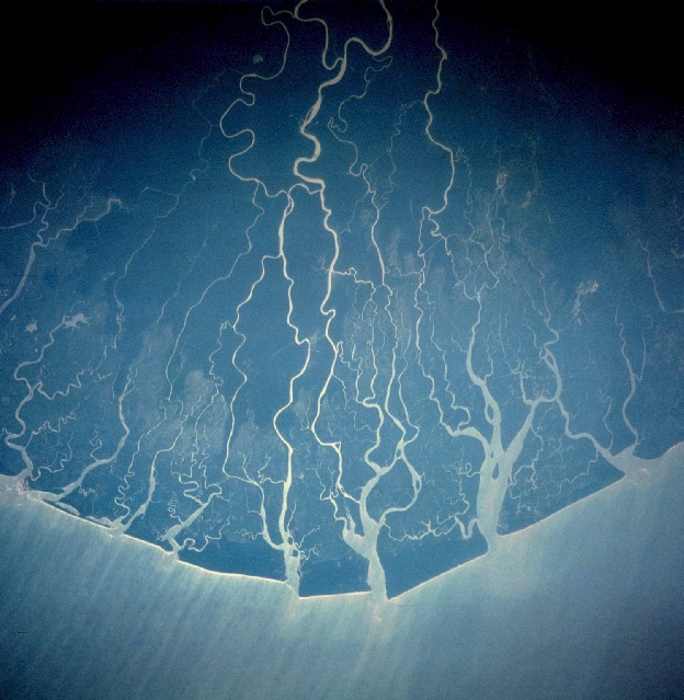
Niger Delta
Image via Wikimedia Commons (author and licence on the file page).

Niger Delta

Delta · 431 km²

Niger Delta is a delta in Africa, covering an estimated 431 km². It extends across Nigeria, Guinea Bissau, Benin, Mali and Niger.

The Niger Delta is a distinct geographic, ecological, and cultural region situated in southern Nigeria, defined by the extensive floodplain and riverine network where the Niger River drains into the Gulf of Guinea on the Atlantic Ocean [1]. Characterized by a unique aquatic ecosystem of mangrove swamps, barrier islands, and saltwater creeks, the true Niger Delta is home to indigenous populations fundamentally shaped by water and bound by shared cultural traditions. These include a lifestyle centered around riverine occupations, a distinct culinary identity featuring local staples like plantain and periwinkle, and the universal use of Nigerian Pidgin as a lingua franca.

Historically referred to by European traders as the Oil Rivers due to its pre-colonial prominence in the palm oil trade, the maritime area formed the British Oil Rivers Protectorate from 1885 until 1893, when it was reorganized as the Niger Coast Protectorate. In the modern era, the delta has become a globally recognized petroleum-rich hub, serving as the core of international concern over extensive oil pollution and ecological degradation frequently characterized as ecocide.

Adapted from Wikipedia: Niger Delta (CC BY-SA 4.0).

Feature class
Delta
Mapped extent
431 km²
Size rank
#191 of 231 landforms
Region
Africa
Countries
Nigeria, Guinea Bissau, Benin, Mali, Niger
Coordinates
4.3147°, 6.2635°
Summits:
Chappal Wadi (2,419 m), Dimlang (2,042 m)
Ranges:
Guinea Highlands (Africa), Loma Mountains (Africa)
Settlements:
Warri (100 km), Port Harcourt (102 km), Owerri (137 km)

View on the live map

More about Niger Delta

Geography and Boundaries

A sharp distinction exists between the natural, cultural Niger Delta and the administrative boundaries utilized by the Nigerian federal government. Geographically and ecologically, the authentic Niger Delta does not conform to modern state lines; it spans a continuous, water-bound coastal belt running from the riverine fringes of western Ondo State (such as the Arogbo kingdom) through the southern coastal tip of Edo State, encompassing roughly two-thirds of Delta State, the entirety of Bayelsa State, the riverine southern halves of Rivers State and Akwa Ibom State, and terminating at the southern maritime border of Cross River State at Bakassi.

History

During the pre-colonial and early colonial eras, the maritime delta operated as a vital commercial arena for the palm oil trade and earlier transatlantic exchanges. The British Empire established the Oil Rivers Protectorate in 1885, later expanding it into the Niger Coast Protectorate in 1893.

Following the amalgamation of Nigeria, the core riverine Niger Delta was administratively placed within the former Eastern Region in 1951. During the late colonial transition, minority ethnic groups within the delta's coastal divisions expressed deep political anxieties regarding marginalisation by larger interior ethnic groups.

Sections adapted from Wikipedia: Niger Delta (CC BY-SA 4.0).

More on Nigeria

Quick Answers

What is the largest landform in Nigeria?
Africa, at 29.41M km². Sahel is second at 1.02M km². Rankings cover the mountain ranges, deserts and other landforms indexed in YearMaps.
How many mountain ranges, deserts and other landforms are there in Nigeria?
YearMaps lists 6 mountain ranges, deserts and other landforms for Nigeria. This is the number mapped in the atlas, not an official national count.