Skip to content
YearMaps
DR Congo · Lakes

Largest Lakes in DR Congo

Lake Tanganyika is the largest of the 9 lakes recorded for DR Congo, at 32,896 km², ahead of Lake Albert at 5,404 km². The full list follows.

How this list is built: Ranked by mapped surface area. A lake on a border is listed under each country it lies in, with the area of the whole lake. It covers the lakes indexed in YearMaps, drawn from open geospatial data, and is not an exhaustive national register.

Lakes Listed
9
Top Ranked
32,896 km²
Lake Tanganyika
Second
5,404 km²
Lake Albert
Profiled Below
5
Photo, encyclopedia text and figures
Largest Lakes in DR Congo
#NameSurface Area
1Lake Tanganyika32,896 km²
2Lake Albert5,404 km²
3Lac Moeru5,057 km²
4Lake Kivu2,693 km²
5Lake Edward2,220 km²
6Lac Mai-Ndombe2,000 km²
7Lac Tumba735 km²
8Lac Upemba506 km²
9Lake Rentenue288 km²

The Lakes of DR Congo in Detail

The 5 lakes above that have an encyclopedia article, in the same order, each with its photograph, figures and the places around it.

Lake Tanganyika
Image via Wikimedia Commons (author and licence on the file page).

Lake Tanganyika

Lake · 32,896 km²

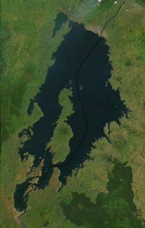
Lake Tanganyika is a lake in Tanzania, the DR Congo, Burundi and Zambia, with a mapped surface area of about 32,896 km². About 43% of its surface lies in the DR Congo, and the rest in Tanzania, Burundi and Zambia.

Lake Tanganyika ( TANG-gən-YEE-kə, -⁠gan-; Kirundi: Ikiyaga ca Tanganyika) is an African Great Lake. It is the world's second-largest freshwater lake by volume and the second deepest, in both cases after Lake Baikal in Siberia. It is the world's longest freshwater lake. It is also the 6th largest lake by area. The lake is shared among four countries—Tanzania, the Democratic Republic of the Congo (the DRC), Burundi, and Zambia—with Tanzania (46%) and the DRC (40%) possessing the majority of the lake. It drains via the Lukuga River into the Congo River system, which ultimately discharges at Banana, Democratic Republic of the Congo into the Atlantic Ocean.

Adapted from Wikipedia: Lake Tanganyika (CC BY-SA 4.0).

Surface area
32,896 km²
Area rank
#6 of 756 indexed
Type
Lake
Countries
Tanzania, DR Congo, Burundi, Zambia
Coordinates
-5.1920°, 29.4808°

Among the 756 water bodies with a mapped extent in YearMaps, Lake Tanganyika ranks #6 by surface area, after Lake Michigan (58,387 km²) and ahead of Lake Baikal (32,120 km²). Areas are computed from the mapped outline and are approximate.

Settlements on the shore:
Kalemie (52 km), Manono (282 km), Uvira (301 km)
Watercourses:
Lukuga (River), Malagarasi (River)
Other water nearby:
Lake Kivu (2,693 km²), Lake Edward (2,220 km²)

View on the live map

More about Lake Tanganyika

Geography

Lake Tanganyika is an ancient lake, one of only twenty more than a million years old. Its three basins, which in periods with lower water levels were separate lakes, are of different ages. The central lake began to form 9–12 million years ago (Mya), the northern 7–8 Mya and the southern 2–4 Mya.

Today Lake Tanganyika is situated within the Albertine Rift, the western branch of the East African Rift, and is confined by the mountainous walls of the valley. It is the largest rift lake in Africa and the second-largest freshwater lake by volume in the world. It is the deepest lake in Africa and holds the greatest volume of fresh water on the continent, accounting for 16% of the world's available fresh water.

History

It is thought that early Homo sapiens were making an impact on the region during the Stone Age. The time period of the Middle Stone Age to Late Stone Age is described as an age of advanced hunter-gatherers.

In the mid–19th century, Swahili Arab traders from Zanzibar established a caravan route from Bagamoyo via Tabora to Ujiji on Lake Tanganyika. They brought sailing dhows to navigate the lake and traded in slaves, ivory, guns and cotton. Chief among these traders was Tippu Tip in the second half of the 19th century, who established a state west of the lake.

The first known Westerners to find the lake were the British explorers Richard Burton and John Speke, in 1858. They located it while searching for the source of the Nile River.

Sections adapted from Wikipedia: Lake Tanganyika (CC BY-SA 4.0).

Lake Tanganyika: Key Facts

Key facts about Lake Tanganyika
Surface area32,900 km²
Maximum depth1,433 m
Volume18,900 km³
Surface elevation773 m
InflowsRuzizi River, Malagarasi River, Kalambo River, Mulobozi
OutflowsLukuga River
Drainage systemCongo Basin

Facts from Wikidata Q5511 (CC0).

Lake Kivu
Image via Wikimedia Commons (author and licence on the file page).

Lake Kivu

Lake · 2,693 km²

Lake Kivu is a lake in the DR Congo and Rwanda, with a mapped surface area of about 2,693 km². About 56% of its surface lies in the DR Congo, and the rest in Rwanda.

Lake Kivu () is one of the African Great Lakes. It lies on the border between the Democratic Republic of the Congo and Rwanda, and is in the Albertine Rift, the western branch of the East African Rift. Lake Kivu empties into the Ruzizi River, which flows southwards into Lake Tanganyika.

In the past, Lake Kivu drained toward the north, contributing to the White Nile. About 13,000 to 9,000 years ago, volcanic activity blocked Lake Kivu's outlet to the watershed of the Nile. The volcanism produced mountains, including the Virungas, which rose between Lake Kivu and Lake Edward, to the north. Water from Lake Kivu was then forced south down the Ruzizi. This, in turn, raised the level of Lake Tanganyika, which overflowed down the Lukuga River.

Lake Kivu is one of three lakes in the world, along with Lake Nyos and Lake Monoun, that undergo limnic eruptions (where overturn of deepwater stratified layers releases dissolved carbon dioxide (CO2)). The lake's bottom also contains methane (CH4). If a limnic eruption occurs, the lives of the two million people living nearby would be in danger.

Adapted from Wikipedia: Lake Kivu (CC BY-SA 4.0).

Surface area
2,693 km²
Area rank
#75 of 756 indexed
Type
Lake
Countries
DR Congo, Rwanda
Coordinates
-1.8067°, 29.1458°

Among the 756 water bodies with a mapped extent in YearMaps, Lake Kivu ranks #75 by surface area, after Lake Peipus (2,758 km²) and ahead of Iliamna Lake (2,677 km²). Areas are computed from the mapped outline and are approximate.

Settlements on the shore:
Goma (41 km), Bukavu (61 km), Uvira (154 km)
Watercourses:
Rusizi (River), Kagera (River)
Other water nearby:
Lake Edward (2,220 km²), Lake Tanganyika (32,896 km²)

View on the live map

More about Lake Kivu

Geography

Lake Kivu is approximately 42 km (26 mi) long and 50 km (31 mi) at its widest. Its irregular shape makes measuring its precise surface area difficult; it has been estimated to cover a total surface area of some 2,700 km2 (1,040 sq mi), making it Africa's eighth largest lake. The surface of the lake sits at a height of 1,460 metres (4,790 ft) above sea level. This lake has a chance of suffering a limnic eruption every 1000 years. The lake has a maximum depth of 475 m (1,558 ft) and a mean depth of 220 m (722 ft), making it the world's twentieth deepest lake by maximum depth, and the thirteenth deepest by mean depth.

The lake bed sits upon a rift valley that is slowly being pulled apart, causing volcanic activity in the area.

Sections adapted from Wikipedia: Lake Kivu (CC BY-SA 4.0).

Lake Kivu: Key Facts

Key facts about Lake Kivu
Surface area2,700 km²
Maximum depth485 m
Surface elevation1,463 m
InflowsKarundura
OutflowsRuzizi River

Facts from Wikidata Q125912 (CC0).

Lake Edward
Image via Wikimedia Commons (author and licence on the file page).

Lake Edward

Lake · 2,220 km²

Lake Edward is a lake in the DR Congo and Uganda, with a mapped surface area of about 2,220 km². About 65% of its surface lies in the DR Congo, and the rest in Uganda.

Lake Edward (locally Rwitanzigye or Rweru) is one of the smaller African Great Lakes. It is located in the Albertine Rift, the western branch of the East African Rift, on the border between the Democratic Republic of the Congo (DRC) and Uganda, with its northern shore a few kilometres south of the equator.

Adapted from Wikipedia: Lake Edward (CC BY-SA 4.0).

Surface area
2,220 km²
Area rank
#90 of 756 indexed
Type
Lake
Countries
DR Congo, Uganda
Coordinates
-0.3004°, 29.6017°

Among the 756 water bodies with a mapped extent in YearMaps, Lake Edward ranks #90 by surface area, after Syvash (2,339 km²) and ahead of Aydar Ko‘l (2,171 km²). Areas are computed from the mapped outline and are approximate.

Settlements on the shore:
Butembo (64 km), Beni (99 km), Goma (146 km)
Watercourses:
Semliki (River), Ituri (River)
Other water nearby:
Lake Kivu (2,693 km²), Lake Tanganyika (32,896 km²)

View on the live map

More about Lake Edward

Geography

Lake Edward lies at an elevation of 920 metres (3,020 ft), is 77 kilometres (48 mi) long by 40 kilometres (25 mi) wide at its maximum points, and covers a total surface area of 2,325 square kilometres (898 mi2), making it the 15th-largest on the continent. The lake is fed by the Nyamugasani River, the Ishasha River, the Rutshuru River, the Ntungwe River, and the Rwindi River. Lake George to the northeast empties into it via the Kazinga Channel. Lake Edward empties to the north via the Semliki River into Lake Albert, where is joins the White Nile, ultimately flowing to the Nile.

The western escarpment of the Great Rift Valley towers up to 2,000 metres (6,600 ft) above the western shore of the lake. The southern and eastern shores are flat lava plains.

History

Welsh explorer Henry Morton Stanley first saw the lake in 1888, during the Emin Pasha Relief Expedition. The lake was named in honour of Albert Edward, Prince of Wales, son of then British monarch Queen Victoria, and later to become King Edward VII.

In 1973, Uganda and the then Zaire (DRC) renamed it Lake Idi Amin after Ugandan dictator Idi Amin. After his overthrow in 1979, it recovered its former name.

In 2014, the lake was the center of an oil dispute. SOCO International entered the premises of the Virunga National Park where the lake is situated to prospect for oil. However, villagers and workers who attempted to stop the oil company from entering the area were beaten up and even kidnapped and tortured.

Ecology

Lake Edward is home to many species of fish, including populations of Bagrus docmak, Oreochromis niloticus, Oreochromis leucostictus, and over 50 species of Haplochromis and other haplochromine species, of which only 25 are formally described. Fishing is an important activity among local residents. Fauna living on the banks of the lake – including chimpanzees, elephants, crocodiles, and lions – are protected by the national parks. The area is also home to many perennial and migratory bird species.

In the 1970s, Lake Edward held a population of around 29,000 hippos in and around the area of the lake. But due to an increase in poaching over the years, there has been a 95% decline in the population, with the population plummeting to only a few hundred by the end of 2006.

Sections adapted from Wikipedia: Lake Edward (CC BY-SA 4.0).

Lake Edward: Key Facts

Key facts about Lake Edward
Surface area2,150 km²
Maximum depth117 m
Surface elevation912 m
InflowsKazinga Channel, Rutshuru River
OutflowsSemliki River
Drainage systemNile basin

Facts from Wikidata Q125211 (CC0).

Lac Mai-Ndombe
Image via Wikimedia Commons (author and licence on the file page).

Lac Mai-Ndombe

Lake · 2,000 km²

Lac Mai-Ndombe is a lake in the DR Congo, with a mapped surface area of about 2,000 km².

Lake Mai-Ndombe (French: Lac Mai-Ndombe, Dutch: Mai-Ndombemeer) is a large freshwater lake in Mai-Ndombe province in western Democratic Republic of the Congo.

The lake is within the Tumba-Ngiri-Maindombe area, the largest Wetland of International Importance recognized by the Ramsar Convention in the world.

Adapted from Wikipedia: Lake Mai-Ndombe (CC BY-SA 4.0).

Surface area
2,000 km²
Area rank
#99 of 756 indexed
Type
Lake
Country
DR Congo
Coordinates
-2.2309°, 18.3658°

Among the 756 water bodies with a mapped extent in YearMaps, Lac Mai-Ndombe ranks #99 by surface area, after Lake Chany (2,032 km²) and ahead of Whitefish Bay (1,959 km²). Areas are computed from the mapped outline and are approximate.

Settlements on the shore:
Inongo (34 km), Bandundu (162 km), Mushie (183 km)
Watercourses:
Fimi (River), Lokoro (River)
Other water nearby:
Lac Tumba (735 km²), Lake Kivu (2,693 km²)

View on the live map

More about Lac Mai-Ndombe

Location

The lake drains to the south through the Fimi River into the Kwah and Congo Rivers. Known until 1972 as Lake Leopold II (French: Lac Léopold II; Dutch: Leopold II-meer) after Leopold II, King of the Belgians. Mai-Ndombe means "black water" in Kikongo. The lake is of irregular shape and ranges in depth from only 5 meters (mean) to 10 meters (maximum). Covering approximately 890 square miles (2,300 square km), it is known to double or triple in size during the rainy season. Its waters are oxygenated throughout their depth and the pH ranges from 4.2 to 5.5. Low, forested shores surround it with dense, humid equatorial rainforest prevailing to the north and a mosaic of forest and savanna to the south.

Sections adapted from Wikipedia: Lake Mai-Ndombe (CC BY-SA 4.0).

Lac Mai-Ndombe: Key Facts

Key facts about Lac Mai-Ndombe
Surface area2,300 km²
Maximum depth10 m
Volume7.1 km³
Surface elevation320 m
InflowsLokoro River
OutflowsFimi River
Drainage systemCongo Basin

Facts from Wikidata Q683100 (CC0).

Lac Tumba
Image via Wikimedia Commons (author and licence on the file page).

Lac Tumba

Lake · 735 km²

Lac Tumba is a lake in the DR Congo, with a mapped surface area of about 735 km².

Lake Ntomba (or Tumba) is a shallow lake in northwestern part of the Democratic Republic of the Congo, in the Bikoro Territory of the Province of Équateur. The naming Tumba comes from a mispronunciation of the name by non native.

The lake covers about 765 square kilometres (295 sq mi) depending on the season, connected via the Irebu channel with the Congo River. Water may flow into or out of the lake through this channel depending on the season and floods. Lake Ntomba has 114 species of fish and supports important fisheries.

The lake lies at the center of the Ntomba-Ngiri-Maindombe area, designated a Wetland of International Importance by the Ramsar Convention in 2008.

Lake Ntomba was explored in 1883 by Henry Morton Stanley.

The swamp forest surrounding the lake is inhabited by the Mongo people, who in this area are divided into two castes: the Oto, who farm, and the Twa, Pygmies who fish.

Adapted from Wikipedia: Lake Tumba (CC BY-SA 4.0).

Surface area
735 km²
Area rank
#240 of 756 indexed
Type
Lake
Country
DR Congo
Coordinates
-0.8184°, 18.0229°

Among the 756 water bodies with a mapped extent in YearMaps, Lac Tumba ranks #240 by surface area, after Sasyqkl (750 km²) and ahead of Lago de Izabal (733 km²). Areas are computed from the mapped outline and are approximate.

Settlements on the shore:
Mbandaka (99 km), Inongo (128 km), Owando (237 km)
Watercourses:
Ruki (River), Sangha (River)
Other water nearby:
Lac Mai-Ndombe (2,000 km²), Lake Kivu (2,693 km²)

View on the live map

More about Lac Tumba

Lac Tumba: Key Facts

Key facts about Lac Tumba
Surface area500 km²
Maximum depth6 m
Surface elevation340 m
OutflowsRiver Congo
Drainage systemCongo Basin

Facts from Wikidata Q1324212 (CC0).

More on DR Congo

Quick Answers

What is the largest lake in DR Congo?
Lake Tanganyika, at 32,896 km². Lake Albert is second at 5,404 km². Rankings cover the lakes indexed in YearMaps.
How many lakes are there in DR Congo?
YearMaps lists 9 lakes for DR Congo. This is the number mapped in the atlas, not an official national count.