
UNESCO World Heritage Sites in DR Congo
DR Congo has 5 sites on the UNESCO World Heritage List (5 natural), the first inscribed in 1979 (Virunga National Park). 4 sites are on the List of World Heritage in Danger. The map below plots every one of them alongside the rest of the List, and each site is written up in full further down the page.
- World Heritage Sites
- 5
- Cultural
- 0
- Natural and Mixed
- 5
- First Inscribed
- 1979
Map of World Heritage Sites in DR Congo
CulturalNaturalMixedIn DangerLarge dots are in DR Congo. Click a dot to read about the site.

Virunga National Park
DR Congo · 0.5000° S, 29.5000° E · 8,000 km² · 74 km from Butembo
Virunga National Park (French: Parc national des Virunga, abbreviated as PNVi) is a national park in the Albertine Rift Valley in the eastern part of the Democratic Republic of the Congo. It was created in 1925. In elevation, it ranges from 680 m (2,230 ft) in the Semliki River valley to 5,109 m (16,762 ft) in the Rwenzori Mountains. From north to south it extends approximately 300 km (190 mi), largely along the international borders with Uganda and Rwanda in the east. It covers an area of 7,800 km2 (3,000 sq mi). It is bounded to the north by the Puemba River and to the south by Tchegera Island in Lake Kivu.
Two active volcanoes, Mount Nyiragongo and Nyamuragira, are located in the park. They have significantly shaped the national park's diverse habitats and wildlife. More than 3,000 faunal and floral species have been recorded, of which more than 300 are endemic to the Albertine Rift including eastern gorilla (Gorilla beringei) and golden monkey (Cercopithecus kandti).
In 1979, the national park was listed as a UNESCO World Heritage Site because of its rich diversity of habitats, exceptional biodiversity and endemism, and its protection of rare mountain gorilla habitat.
Adapted from Wikipedia: Virunga National Park (CC BY-SA 4.0).
Why Virunga National Park Is Listed
- (vii)
- Superlative natural phenomena or exceptional natural beauty.
- (viii)
- An outstanding example of major stages of the Earth's history.
- (x)
- The most important natural habitats for conserving biodiversity.
More about Virunga National Park
UNESCO's Description
Virunga National Park (covering an area of 790,000 ha) comprises an outstanding diversity of habitats, ranging from swamps and steppes to the snowfields of Rwenzori at an altitude of over 5,000 m, and from lava plains to the savannahs on the slopes of volcanoes. Mountain gorillas are found in the park, some 20,000 hippopotamuses live in the rivers and birds from Siberia spend the winter there.
From the UNESCO World Heritage Centre (CC BY-SA IGO 3.0).
Geography
Virunga National Park is located in the Congo − Nile watershed area, and it is divided into three administrative sectors: North, Central, and South. The Northern Sector adjoins Uganda's Semuliki National Park and Rwenzori Mountains National Park. Elevations in the sector range from 680 m (2,230 ft) in the Puemba River valley to the highest peak of Mount Stanley at 5,109 m (16,762 ft) within 30 km (19 mi). Spanning 299,523 ha, it is the park's largest land-based area, stretching from the Puemba River to Lake Edward and featuring the Semliki River, the Rwenzori Mountains, and Mount Tshiaberimu.
The Central Sector encompasses the western and southern shores of Lake Edward as well as the Rwindi–Rutshuru plains up to Mabenga.
History
In the early 1920s, several proponents of the European conservation movement championed the idea of creating a protected area in northeastern Belgian Congo, among them Victor van Straelen, Jean Massart and Jean-Marie Derscheid. When Albert National Park was established in April 1925 as the Congo's first national park, it was conceived as a science-oriented nature reserve with the aim of studying and preserving wildlife and so-called "primitive" hunter-gatherer African Pygmies. In 1926, Derscheid headed the first Belgian mission to map Albert National Park, which encompassed an area of 500 km2 (190 sq mi) around the extinct volcanoes Mount Karisimbi and Mount Mikeno.
Sections adapted from Wikipedia: Virunga National Park (CC BY-SA 4.0).
Key Facts
| Established | 1925 |
|---|---|
| Area | 7,900 km² |
Facts from Wikidata Q223589 (CC0).
Visiting Virunga National Park
Virunga National Park is in the Democratic Republic of the Congo. It was declared a UNESCO World Heritage site in 1979, but was labelled a site in danger in 1994 due to political conflict and poaching.
Travel notes adapted from Wikivoyage: Virunga National Park (CC BY-SA 4.0).

Garamba National Park
DR Congo · 4.0000° N, 29.2500° E · 5,127 km² · 111 km from Watsa
Garamba National Park (French: Parc national de la Garamba) is a national park in the north-eastern Democratic Republic of the Congo covering nearly 5,200 km2 (2,000 sq mi). It is among Africa's oldest parks and was designated a World Heritage Site by UNESCO in 1980 for its protection of critical habitat for northern white rhinoceroses, African elephants, hippopotamuses, and giraffes. Garamba National Park has been managed by African Parks in partnership with the Institut Congolais pour la Conservation de la Nature since 2005.
Adapted from Wikipedia: Garamba National Park (CC BY-SA 4.0).
Why Garamba National Park Is Listed
- (ix)
- An outstanding example of ongoing ecological and biological processes.
- (x)
- The most important natural habitats for conserving biodiversity.
More about Garamba National Park
UNESCO's Description
The property, located in the north-eastern Democratic Republic of the Congo, forms part of one of the last extensive and continuous forest–savanna mosaic landscapes in Central Africa. Representing a major ecological transition zone between the Guineo-Congolian forest biome and the Sudanian savanna, it encompasses a diverse range of habitats, including grasslands, wooded savannas, semi-deciduous forests, rivers, gallery forests, marshes, and papyrus wetlands. Ecological processes such as fire, herbivory, and seasonal flooding continue to shape the landscape and maintain its forest–savanna dynamics. The park supports a rich assemblage of wildlife, including significant populations of African Forest Elephants, Kordofan Giraffes, Common Hippopotamuses, African buffaloes, lions, pangolins, and numerous primate species. It is home to more than 150 mammal species, 459 bird species, 83 reptile species, and 43 amphibian species, including threatened and regional endemic species.
From the UNESCO World Heritage Centre (CC BY-SA IGO 3.0).
History
The park was designated a World Heritage Site by UNESCO in 1980, and was included on the specialized agency's List of World Heritage in Danger from 1984–1992. Between 1991 and 1993, 50,000 Sudanese refugees settled outside Garamba after being displaced by the Sudan People's Liberation Army, resulting in increased poaching. There were reportedly 121 conflicts between poachers and park rangers between 1993 and 1995, and more than 900 weapons recovered by rangers during 1991–1996. The International Rhino Foundation provided funding for patrol vehicles in 1994, and ranger salaries in 1995. In February 1996, two rhinos—one male, Bawesi, and Juliet, a pregnant female—were killed. Garamba was added back to the danger list in 1996 because of northern white rhinoceros poaching.
Overview
Garamba National Park was established in 1938 and covers an area of 4,900 km2 (1,900 sq mi) in northeastern Democratic Republic of the Congo. It is bounded by Gangala-na-Bodio Hunting Reserve on the west, south, and east, and borders South Sudan on the north and northeast. It is part of the Sudano–Guinean savanna zone. The park is one of Africa's oldest protected areas. It lies in the transition zone between two centres of endemism: Guinea-Congolian and Guinean-Sudanese savanna. These two biogeographic zones support a variety of wildlife, which have experienced population declines in recent decades because of poaching. ICCN rangers, augmented with soldiers of the Armed Forces of the Democratic Republic of the Congo, work to protect Garamba from poachers and rebel groups.
Sections adapted from Wikipedia: Garamba National Park (CC BY-SA 4.0).
Key Facts
| Established | 1938 |
|---|---|
| Area | 4,920 km² |
Facts from Wikidata Q308893 (CC0).
Visiting Garamba National Park
Garamba National Park is a national park in the Democratic Republic of the Congo. It was declared a UNESCO World Heritage site in 1980. It was labelled a site in danger in 1980, removed in 1991, but regained the status in 1996 due to poaching and a fall in rhino numbers.
Travel notes adapted from Wikivoyage: Garamba National Park (CC BY-SA 4.0).

Kahuzi-Biéga National Park
DR Congo · 2.3148° S, 28.7587° E · 6,000 km² · 24 km from Bukavu
The Kahuzi-Biega National Park (Swahili: Hifadhi ya Taifa ya Kahuzi-Biega, French: Parc national de Kahuzi-Biega) is a protected area near Bukavu town in eastern Democratic Republic of the Congo. It is situated near the western bank of Lake Kivu and the Rwandan border.
Adapted from Wikipedia: Kahuzi-Biéga National Park (CC BY-SA 4.0).
Why Kahuzi-Biéga National Park Is Listed
- (x)
- The most important natural habitats for conserving biodiversity.
More about Kahuzi-Biéga National Park
UNESCO's Description
A vast area of primary tropical forest dominated by two spectacular extinct volcanoes, Kahuzi and Biega, the park has a diverse and abundant fauna. One of the last groups of eastern lowland (graueri) gorillas (consisting of only some 250 individuals) lives at between 2,100 and 2,400 m above sea-level.
From the UNESCO World Heritage Centre (CC BY-SA IGO 3.0).
Geography
With an area of 6,000 km2 (2,300 sq mi), Kahuzi-Biega is one of the biggest national parks in the country. Set in both mountainous and lowland terrain, the park lies west of the town of Bukavu in South Kivu Province. The smaller, 600 km2 (230 sq mi) eastern part of the park lies in the Mitumba Mountains of the Albertine Rift in the Great Rift Valley. The larger, 5,400 km2 (2,100 sq mi) western part is mainly lowland terrain stretching from Bukavu to Kisangani. It is drained by the Luka and Lugulu rivers which flow into the Lualaba River. A 7.4 km (4.6 mi) wide corridor connects the two parts. Two dormant volcanoes are set within the park's limits and lend their names to it: Kahuzi (3,308 m (10,853 ft)) and Biéga (2,790 m (9,150 ft)).
History
The earliest reserve, the Zoological and Forest Reserve of Mount Kahuzi, was created on 27 July 1937 by the then Governor General of the Belgian Colonial administration. That reserve has been part of the Kahuzi-Biega National Park since November 1970 when it was established in 1970 by the Belgian photographer and conservationist Adrien Deschryver. Five years later, the park was extended to cover 6,000 km2 (2,300 sq mi).
The park was declared a UNESCO World Heritage Site in 1980, under Criterion (x) for its unique habitat of rainforest and diversity of the mammal species, particularly eastern lowland gorillas.
In 1997 the park was put on the List of World Heritage in Danger because of the political instability of the region, an influx of refugees and increasing wildlife exploitation.
Sections adapted from Wikipedia: Kahuzi-Biéga National Park (CC BY-SA 4.0).
Key Facts
| Established | 1970 |
|---|---|
| Area | 6,000 km² |
Facts from Wikidata Q457324 (CC0).
Salonga National Park
DR Congo · 2.0000° S, 21.0000° E · 36,000 km²
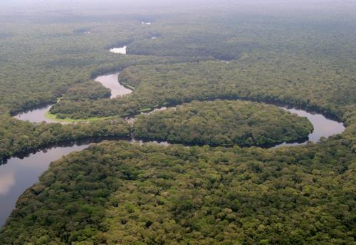
Salonga National Park (French: Parc National de la Salonga) is a national park in the Democratic Republic of the Congo located in the Congo River basin. It is Africa's largest tropical rainforest reserve covering about 36,000 km2 or 3,600,000 hectares (8,900,000 acres). It extends into the provinces of Mai Ndombe, Equateur, Kasaï and Sankuru. In 1984, the national park was inscribed on the UNESCO World Heritage List for its protection of a large swath of relatively intact rainforest and its important habitat for many rare species. In 1999, the site has been listed as endangered due to poaching and housing construction. Following the improvement in its state of conservation, the site was removed from the endangered list in 2021.
Adapted from Wikipedia: Salonga National Park (CC BY-SA 4.0).
Why Salonga National Park Is Listed
- (vii)
- Superlative natural phenomena or exceptional natural beauty.
- (ix)
- An outstanding example of ongoing ecological and biological processes.
More about Salonga National Park
UNESCO's Description
Salonga National Park is Africa's largest tropical rainforest reserve. Situated at the heart of the central basin of the Congo river, the park is very isolated and accessible only by water. It is the habitat of many endemic endangered species, such as the dwarf chimpanzee, the Congo peacock, the forest elephant and the African slender-snouted or 'false' crocodile.
From the UNESCO World Heritage Centre (CC BY-SA IGO 3.0).
Geography
The park is in an area of rainforest about halfway between Kinshasa, the capital, and Kisangani. There are no roads and most of the park is accessible only by river. Sections of the national park are almost completely inaccessible and have never been systematically explored. The southern region inhabited by the Iyaelima people is accessible via the Lokoro River, which flows through the center and northern parts of the park, and the Lula River in the south.
The Salonga River meanders in a generally northwest direction through the Salonga National Park to its confluence with the Busira River.
Ecology
Located in the center of the Congo Basin, Salonga National Park protects the largest rainforest in Africa and the second largest in the world. The large size and ecological complexity of this rainforest has allowed species and communities to evolve relatively undisturbed. As a result, the national park protects a highly biodiverse and unique ecosystem. Of 735 identified plant species in the southwestern part of the park, 85% rely on animals to disperse their seeds, a process called zoochory.
Many large mammals are found within the park at relatively high densities, including Bongo antelopes, black-crested mangabeys, leopards, and bonobos. The southern region has been the location for studies of bonobos in the wild.
History
The Salonga National Park was established as the Tshuapa National Park in 1956, and gained its present boundaries with a 1970 presidential decree by President Mobutu Sese Seko. It was registered as a UNESCO World Heritage Site in 1984. Due to the civil war in the eastern half of the country, it was added to the List of World Heritage in Danger in 1999.
The park is co-managed by the Institut Congolais pour la Conservation de la Nature and the World Wide Fund for Nature since 2015. Extensive consultation is ongoing, with the two main populations living within the park; the Iyaelima, the last remaining residents of the park and the Kitawalistes, a religious sect who installed them-self in the park just after its creation.
Sections adapted from Wikipedia: Salonga National Park (CC BY-SA 4.0).
Key Facts
| Established | 1970 |
|---|---|
| Area | 36,000 km² |
Facts from Wikidata Q328488 (CC0).
Visiting Salonga National Park
Salonga National Park is in the Democratic Republic of the Congo. It was declared a UNESCO World Heritage site in 1984, but was labelled a site in danger in 1999 due to urban development and poaching. The park is Africa's largest tropical rainforest preserve and is home to many endangered endemic animals.
Travel notes adapted from Wikivoyage: Salonga National Park (CC BY-SA 4.0).

Okapi Wildlife Reserve
DR Congo · 2.0000° N, 28.5000° E · 13,726 km² · 59 km from Wamba
The Okapi Wildlife Reserve (French: Réserve de faune à okapis) is a wildlife reserve in the Ituri Forest in the north-east of the Democratic Republic of the Congo, near the borders with South Sudan and Uganda. At approximately 14,000 km2, it covers approximately one-fifth of the area of the forest. In 1996, the Okapi Wildlife Reserve was designated a UNESCO World Heritage Site, due to its large population of endangered okapis and its high overall biodiversity. As of March 2026, the reserve is occupied and seriously threatened by the presence of Islamist terrorists from the Allied Democratic Forces who in 2025 killed more than 1700 civilians in the wider region of northeast Congo.
Adapted from Wikipedia: Okapi Wildlife Reserve (CC BY-SA 4.0).
Why Okapi Wildlife Reserve Is Listed
- (x)
- The most important natural habitats for conserving biodiversity.
More about Okapi Wildlife Reserve
UNESCO's Description
The Okapi Wildlife Reserve occupies about one-fifth of the Ituri forest in the north-east of the Democratic Republic of the Congo. The Congo river basin, of which the reserve and forest are a part, is one of the largest drainage systems in Africa. The reserve contains threatened species of primates and birds and about 5,000 of the estimated 30,000 okapi surviving in the wild. It also has some dramatic scenery, including waterfalls on the Ituri and Epulu rivers. The reserve is inhabited by traditional nomadic pygmy Mbuti and Efe hunters.
From the UNESCO World Heritage Centre (CC BY-SA IGO 3.0).
Ecology
The wildlife reserve makes up roughly one-fifth of the total area of the Ituri Forest. As a Pleistocene refugium, the forest contains dense evergreen and semi-evergreen forests, dominated by Mbau trees (Gilbertiodendron dewevrei). The Nepoko, Ituri, and Epulu rivers flow through the reserve, surrounded by swamp forests. Granite outcrops in the north of the reserve protect critical habitat for Encephalartos ituriensis, a threatened species of cycad.
Because of its relatively stable climate during the repeated ice ages, the wildlife reserve, and the Ituri Forest as a whole, protects a unique biological community. As its name implies, the Okapi Wildlife Reserve is home to many okapis. As of 1996, the number was estimated at 3900–6350, out of a global population of around 10,000–20,000.
History
The Okapi Wildlife Reserve was created with the help of the Okapi Conservation Project in 1992. The project continues to support the reserve by training and equipping wildlife guards and by providing assistance to improve the lives of neighboring communities. The Okapi Wildlife Reserve was added to the list of World Heritage Sites in danger in 1997. Threats include the deforestation caused by slash and burn agriculture, and commercial hunting for the sale of bushmeat. Gold mining has also been problematic. As of 2005, the fighting in the eastern part of the country entered the reserve, causing its staff to flee or be evacuated. Lack of funding due to the poor political and economic conditions of the Democratic Republic of the Congo has also been problematic.
Sections adapted from Wikipedia: Okapi Wildlife Reserve (CC BY-SA 4.0).
Key Facts
| Established | 1992 |
|---|---|
| Area | 13,726 km² |
Facts from Wikidata Q457304 (CC0).
World Heritage in DR Congo: Quick Answers
- How many UNESCO World Heritage Sites are in DR Congo?
- DR Congo has 5 World Heritage Sites: 5 natural.
- What was the first World Heritage Site in DR Congo?
- Virunga National Park, inscribed in 1979. The most recent is Okapi Wildlife Reserve, inscribed in 1996.
- What are the natural World Heritage Sites in DR Congo?
- Virunga National Park, Garamba National Park, Kahuzi-Biéga National Park, Salonga National Park, Okapi Wildlife Reserve.
- Are any World Heritage Sites in DR Congo in danger?
- Yes: Virunga National Park, Garamba National Park, Kahuzi-Biéga National Park, Okapi Wildlife Reserve are on UNESCO's List of World Heritage in Danger.