
Map of Antigua and Barbuda
Antigua and Barbuda is a country in North America with its capital at Q36262, home to about 94,209 people across 440 km². The interactive map below plots 1 cities and towns, 1 mountain summits and 1 ports recorded for Antigua and Barbuda in YearMaps.
- Population
- 94,209
- Area
- 440 km²
- Capital
- Q36262
- Continent
- North America
Interactive Map of Antigua and Barbuda
Centred on Q36262 at 17.1180° N, 61.8500° W. Use the layer panel to switch on rivers, dams, ports, peaks and historical borders.
About Antigua and Barbuda
Antigua and Barbuda is an archipelagic country in the Caribbean composed of Antigua, Barbuda, and dozens of other small islands. Antigua and Barbuda has a total area of 440 km2 (170 sq mi), making it one of the smallest countries in the Caribbean. The country is mostly flat, with the highest points on Antigua being in the Shekerley Mountains and on Barbuda the Highlands. The country has a tropical savanna climate, with pockets of tropical monsoon in Antigua's southwest. Its most populated city is St. John's, followed by All Saints and Bolans. The sole settlement in Barbuda is Codrington. Most of the country resides in the Central Plain that stretches from St. John's to English Harbour.
Bounded by the Atlantic Ocean on the east and the Caribbean Sea on the west, Antigua and Barbuda is located within the Leeward Islands moist forest and Leeward Islands xeric scrub ecoregions. The country shares maritime borders with Anguilla, Saint Barthélemy, and Saint Kitts and Nevis to the west, Montserrat to the southwest, and Guadeloupe to the south. Antigua and Barbuda has numerous natural parks, including Codrington Lagoon, one of the largest internal bodies of water in the Lesser Antilles. Despite its dense population, the country has large swaths of undeveloped land, however, Antigua and Barbuda has experienced many environmental issues due to climate change.
Hunter-gatherers settled the islands starting around 3700 BC, likely arriving on canoes from Central and South America. They were followed by the Arawaks of Venezuela during the Ceramic period. In 1493, Christopher Columbus surveyed the island of Antigua, which resulted in an attempt at Spanish settlement in 1520. Antigua remained uncolonised until 1632 when Edward Warner and his small party created the first successful British colony. Barbuda was under the control of the Codrington family until the 1860s. Antiguan independence was first proposed by Prince Klaas in 1728, who attempted to make the island an independent kingdom. After emancipation in 1834, Antigua's autonomy slowly increased, while Barbuda was slowly integrated into Antigua. The first democratic elections were held in 1951, and by 1981, Antigua and Barbuda was independent. From 1960 until 2004, the Bird family dominated the archipelago's politics with only one interruption, which ended with the election of Baldwin Spencer to the premiership.
Since 2014, the Labour Party has dominated national politics.
Summary adapted from Wikipedia: Antigua and Barbuda (CC BY-SA 4.0).

Geography and Climate of Antigua and Barbuda
The Siboney were the first people to inhabit the islands of Antigua and Barbuda in 2400 B.C., but the Arawaks populated the islands when Christopher COLUMBUS landed on his second voyage in 1493. Early Spanish and French settlements were succeeded by an English colony in 1667. Slavery, which provided labor on the sugar plantations on Antigua, was abolished in 1834. The islands became an independent state within the British Commonwealth of Nations in 1981. In 2017, Hurricane Irma passed over the island of Barbuda, devastating the island and forcing the evacuation of the population to Antigua. Almost all of the structures on Barbuda were destroyed and the vegetation stripped, but Antigua was spared the worst.
- Location
- Caribbean, islands between the Caribbean Sea and the North Atlantic Ocean, east-southeast of Puerto Rico.
- Climate
- Tropical maritime; little seasonal temperature variation.
- Terrain
- Mostly low-lying limestone and coral islands, with some higher volcanic areas.
- Highest point
- Mount Obama 402 m.
- Lowest point
- Caribbean Sea 0 m.
- Coastline
- 153 km.
- Land borders
- Total: 0 km.
- Natural resources
- NEGL; pleasant climate fosters tourism.
- Land use
- Agricultural land: 20.5% (2023 est.); arable land: 9.1% (2023 est.); permanent crops: 2.3% (2023 est.); permanent pasture: 9.1% (2023 est.); forest: 18% (2023 est.); other: 61.5% (2023 est.)
- Natural hazards
- Hurricanes and tropical storms (July to October); periodic droughts.
- Geographic note
- Antigua has a deeply indented shoreline with many natural harbors and beaches; Barbuda has a large western harbor.
- Languages
- English (official), Antiguan Creole (an English-based creole)
- Religions
- Protestant 68.3% (Anglican 17.6%, Seventh Day Adventist 12.4%, Pentecostal 12.2%, Moravian 8.3%, Methodist 5.6%, Wesleyan Holiness 4.5%, Church of God 4.1%, Baptist 3.6%), Roman Catholic 8.2%, other 12.2%, unspecified 5.5%, none 5.9% (2011 est.)
- Ethnic groups
- African descent 87.3%, mixed 4.7%, Hispanic 2.7%, White 1.6%, other 2.7%, unspecified 0.9% (2011 est.)
- Economy
- Dual island-tourism and construction-driven economy; emerging “blue economy”; limited water supply and susceptibility to hurricanes limit activity; improving road infrastructure; friendly to foreign direct investment; looking at financial innovation in cryptocurrency and blockchain technologies.
From the CIA World Factbook (public domain), archived edition of 2026-01-22. The Factbook is no longer updated, so figures reflect that edition.
Antigua and Barbuda in Numbers
- Population
- 94,209
- GDP
- US$2.3 billion
- GDP per person
- US$24,819
- Life expectancy
- 77.8 years
- Population growth
- 0.47% a year
- Population density
- 213 per km²
- Urban population
- 24.3%
- Surface area
- 440 km²
- Forest cover
- 17.9%
- Arable land
- 9.1%
- Access to electricity
- 100.0%
- Internet users
- 72.7%
Indicators from World Bank Open Data (CC BY 4.0). The year under each figure is its reference year.
Antigua and Barbuda in Depth
History
Archaic-period hunter-gatherers called the Ciboney were the first culture present in Antigua and Barbuda. Carbon dating has established the earliest settlements started around 3700 BC. They were succeeded by the ceramic age pre-Columbian Arawak-speaking Saladoid people who migrated from the lower Orinoco River. They introduced agriculture, raising, among other crops, the Antigua black pineapple (Ananas comosus), corn, sweet potatoes, chillies, guava, tobacco, and cotton. Later on the Caribs settled the island.
Christopher Columbus was the first European to sight the islands in 1493.
Geography
Limestone formations, rather than volcanic activity, have had the most impact on the topography of both Antigua and Barbuda, which are both relatively low-lying islands. Boggy Peak, also known as Mt. Obama from 2008 to 2016, is the highest point on both Antigua and Barbuda. It is the remnant of a volcanic crater and rises a total of 402 meters. Boggy Peak is located in the southwest of Antigua (1,319 feet).
Both of these islands have very irregularly shaped coastlines that are dotted with beaches, lagoons, and natural harbours. There are reefs and shoals that surround the islands on all sides. Because of the low amount of rainfall, there are not many streams. On neither of these islands can sufficient quantities of fresh groundwater be found.
Economy
Tourism dominates the economy, accounting for more than half of the gross domestic product (GDP). As a destination for the most affluent travelers, Antigua is well known for its extensive collection of five-star resorts. However, weaker tourist activity in lower and middle market segments since the beginning of the year 2000 has slowed the economy and put the government into a tight fiscal corner. Antigua and Barbuda has enacted policies to attract high-net-worth citizens and residents, such as abolishing personal income tax in 2016.
The provision of investment banking and financial services also constitutes a significant portion of the economy. Major international financial institutions such as the Royal Bank of Canada (RBC) and Scotiabank both maintain offices in Antigua.
Demographics
The National Bureau of Statistics estimated a population of 106,365 in 2026, making Antigua and Barbuda one of the least populated countries in the Caribbean. This is an increase of 24% from the 2011 census. Between 2008 and 2020, Antigua and Barbuda had an average of 1,188 live births per year, or one birth every seven hours. In 2011, 62% of Antiguans and Barbudans aged fifteen or over were never married, 27% were married, 5% were divorced or separated, and 3% were widowed. In 2022, the total fertility rate stood at 1.6 children per woman, significantly lower than the average of Caribbean small states.
Sections adapted from Wikipedia: Antigua and Barbuda (CC BY-SA 4.0).
Antigua and Barbuda: Key Facts
| Currency | Eastern Caribbean dollar |
|---|---|
| Official languages | English, Spanish |
| Head of state | Charles III |
| Head of government | Gaston Browne |
| Form of government | constitutional monarchy |
| Calling code | +1268 |
| Internet domain | .ag |
| Highest point | Mount Obama |
| Lowest point | Caribbean Sea |
| Established | 1 November 1981 |
Facts from Wikidata Q781 (CC0).
Visiting Antigua and Barbuda
Antigua and Barbuda are two Caribbean islands that form a country that lies between the Caribbean Sea and the North Atlantic Ocean, east-southeast of Puerto Rico.
Travel notes adapted from Wikivoyage: Antigua and Barbuda (CC BY-SA 4.0).
Largest Cities in Antigua and Barbuda
1 city recorded. Ranked by metropolitan population. A port city's harbour is written up on the page of its sea.
| # | Name | Population | Region | Role |
|---|---|---|---|---|
| 1 | Saint John's | 35,499 | — | National capital |
Highest Mountains in Antigua and Barbuda
1 mountain recorded. Ranked by summit elevation above sea level. A summit on a border is listed under both countries.
| # | Name | Elevation | Feet | Region |
|---|---|---|---|---|
| 1 | Mount Obama | 402 m | 1,319 ft | North America |
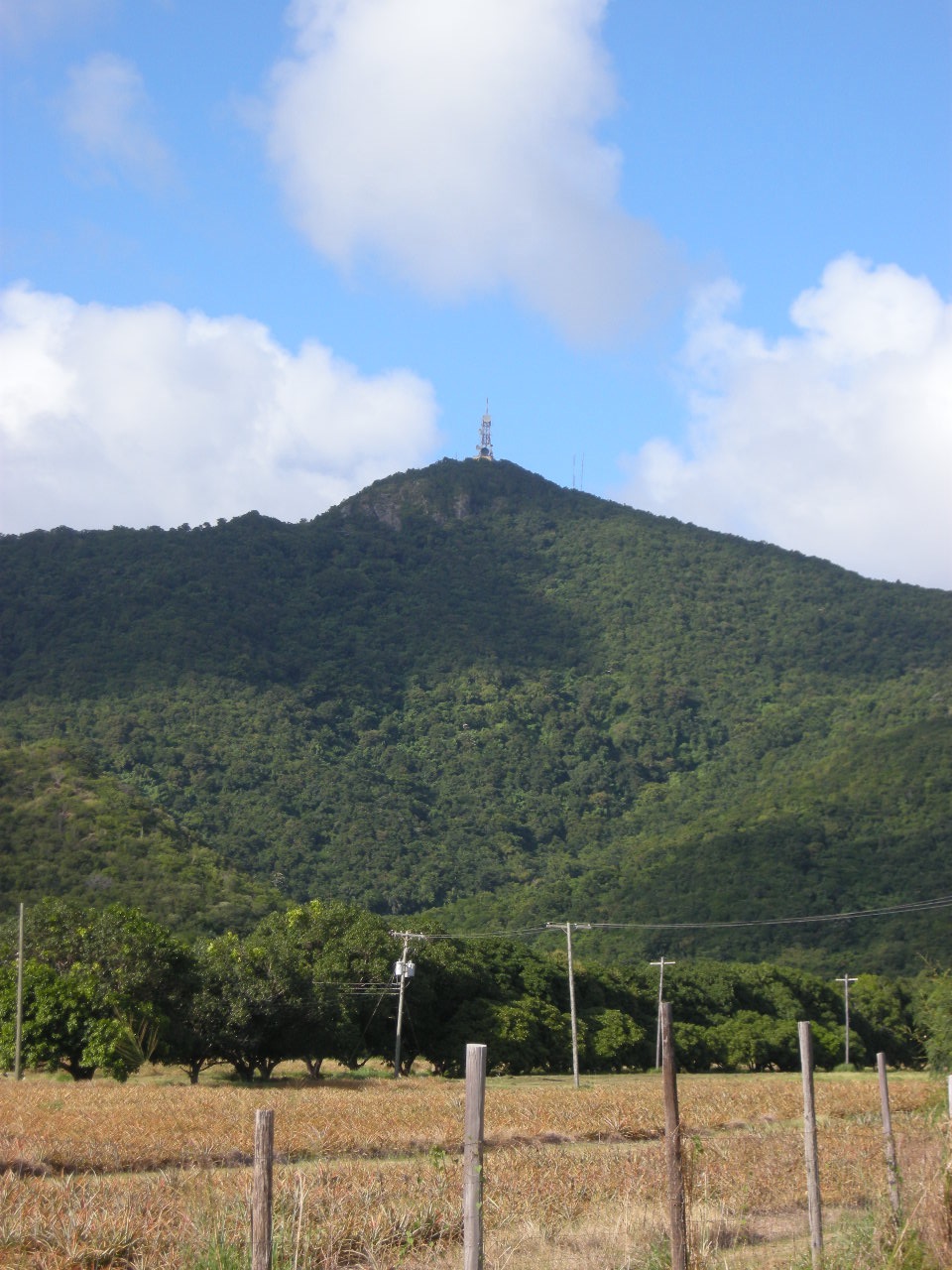
Mount Obama
Mountain · 402 m
Mount Obama is a mountain rising to 402 metres (1,319 ft) in Antigua and Barbuda, in the North America region. From PeakBagger.com, with kind permission..
Boggy Peak () is a mountain located in the southwest of Antigua, a constituent island of the archipelagic country of Antigua and Barbuda. At a height of 1,319 feet (402 m), it is the highest point of the Shekerley Mountains and the island as a whole.
In 2009, Boggy Peak was renamed Mount Obama by then prime minister of Antigua and Barbuda Baldwin Spencer, in honour of then US president Barack Obama. The name change was criticised by the parliamentary opposition at the time and reverted in 2016 by the government that succeeded Spencer's.
Adapted from Wikipedia: Boggy Peak (CC BY-SA 4.0).
- Elevation
- 402 m (1,319 ft)
- Global rank
- #617 of 641 indexed
- Region
- North America (#130)
- Subregion
- West Indies
- Country
- Antigua and Barbuda
- Coordinates
- 17.0434°, -61.8367°
Of the 641 named summits indexed in YearMaps, Mount Obama ranks #617 by elevation, below Mount Lamlam (406 m) and above Taal Volcano (400 m).
- Ranges:
- Wilhelmina Gebergte (South America), Tumuc-Humac Mountains (South America)
- Neighbouring summits:
- Soufrière Hills Volcano (914 m), Mount Scenery (870 m), Morne Diablotins (1,447 m)
- Settlements below:
- Saint John's (8 km), Pointe-à-Pitre (95 km), Basseterre (98 km)
More about Mount Obama
Geography
Boggy Peak lies in the southwest corner of Antigua and is a part of the Shekerley Mountains. It rises to a height of 1,319 feet (402 m), making it the highest point of the Shekerley Mountains and the highest point on Antigua.
History
Boggy Peak was historically the location of sugarcane plantations toiled by plantation slaves. The name Boggy Peak originated from slave masters who told stories about the dangers of the bogeyman (local spelling boggy man) who lived on the mountain. This was done to discourage slaves from escaping and running away.
On 5 November 2008, then prime minister of Antigua and Barbuda Baldwin Spencer sent a congratulatory letter to then US president-elect Barack Obama, in which he expressed his intention to change the name of Boggy Peak to Mount Obama. Political analyst Avel Grant commented that the move could attract tourism to the island. The name change was made official on 4 August 2009 and criticised by members of the opposition Labour Party, who called the decision "silly".
Sections adapted from Wikipedia: Boggy Peak (CC BY-SA 4.0).
Mount Obama: Key Facts
| Topographic prominence | 402 m |
|---|---|
| Mountain range | Shekerley Mountains |
Facts from Wikidata Q1718336 (CC0).
Ports in Antigua and Barbuda
1 port recorded. Ranked by approach channel depth, the figure that limits which ships can call. Harbours link to their write-up on the page of the sea or coast they lie on.
| # | Name | Channel Depth | Class | Sea | Max Vessel |
|---|---|---|---|---|---|
| 1 | St Johns | 38.4 m | Minor | Caribbean Sea | large vessels |
UNESCO World Heritage Sites in Antigua and Barbuda
1 World Heritage Site recorded. Listed by year of inscription, earliest first. Sites shared with another country appear under each.
| # | Name | Inscribed | Type | Criteria |
|---|---|---|---|---|
| 1 | Antigua Naval Dockyard and Related Archaeological Sites | 2016 | Cultural | (ii) (iv) |
Countries Bordering Antigua and Barbuda
Land and maritime neighbours.
More Maps in North America
Antigua and Barbuda: Quick Answers
- What is the capital of Antigua and Barbuda?
- The capital of Antigua and Barbuda is Q36262.
- What is the population of Antigua and Barbuda?
- Antigua and Barbuda has a population of about 94,209, the #200 largest of 225 countries in YearMaps. Source: World Bank, 2025.
- How big is Antigua and Barbuda?
- Antigua and Barbuda covers 440 km², ranking #203 by area, with about 214 people per square kilometre.
- Which continent is Antigua and Barbuda in?
- Antigua and Barbuda is in North America.
- Which countries border Antigua and Barbuda?
- Antigua and Barbuda shares a land or maritime border with United Kingdom.
- What is the largest city in Antigua and Barbuda?
- Saint John's is the largest city in Antigua and Barbuda, with a metropolitan population of about 35,499.
- What is the highest mountain in Antigua and Barbuda?
- The highest summit recorded for Antigua and Barbuda in YearMaps is Mount Obama at 402 m (1,319 ft). Summits on a border are counted for both countries.