
Periyar
Periyar is a mapped river in the YearMaps hydrographic index. 5 dams stand on this watercourse and its tributaries and are written up below. River courses organise settlement, agriculture and frontier-making more durably than any political boundary, and this reach is indexed against the dams, lakes and cities within its catchment.
- Feature Class
- River
- Dams Recorded
- 5
- Coordinates
- 9.84°, 76.97°
About Periyar
The Periyar (Malayalam: [peɾijaːr], meaning: big river) is the longest river and has the largest discharge potential in the Indian state of Kerala. It is one of the few perennial rivers in the region and provides drinking water for several major towns. The Periyar is vital to the economy of Kerala because it generates a significant proportion of Kerala's electrical power via the Idukki Dam and it flows along a region of industrial and commercial activity. The river also provides water for irrigation, domestic water use, and supports a rich fishery. Due to these reasons, the river has been named the "Lifeline of Kerala". Kochi city, in the vicinity of the river mouth, draws its water supply from Aluva, an upstream site sufficiently free of seawater intrusion. Twenty five percent of Kerala's industries are along the banks of the Periyar. These are mostly crowded within a stretch of 5 kilometres (3 mi) in the Eloor-Edayar region (Udhyogamandal), about 10 kilometres (6 mi) north of Kochi harbor.
Encyclopedic summary adapted from Wikipedia: Periyar River (CC BY-SA 4.0).
Periyar in Depth
Tributaries
Although the Chalakudy river in strict geological sense is a tributary of the Periyar, for all practical purposes it is treated as a separate river by Government and other agencies. Chalakudy river itself has a catchment area of 1,704 square kilometres (658 mi2), with 1,404 square kilometres (542 mi2) in Kerala and 300 square kilometres (116 mi2) in Tamil Nadu.
Sections adapted from Wikipedia: Periyar River (CC BY-SA 4.0).
Periyar: Key Facts
| Length | 244 km |
|---|---|
| Drainage basin | 5,398 km² |
| Source | Western Ghats |
| Mouth | Vembanad |
| Tributaries | Chalakudy River |
Facts from Wikidata Q2634049 (CC0).
Dams on the Periyar
5 dams on the Periyar and the tributaries that feed it, ordered by structural height, with their reservoirs and generating capacity.
| Dam | River | Height | Capacity | Completed |
|---|---|---|---|---|
| Idukki Dam | Periyar | 169 m | 780 MW | 1976 |
| Cheruthoni Dam | Periyar | 138 m | 780 MW | 1976 |
| Kulamavu Dam | Periyar | 100 m | 780 MW | 1977 |
| Sholayar Dam | Chalakkudy | 66 m | 54 MW | 1965 |
| Mullaperiyar Dam | Periyar | 53.6 m | 140 MW | 1895 |
Idukki Dam
Double Curvature Arch dam · Kerala, India
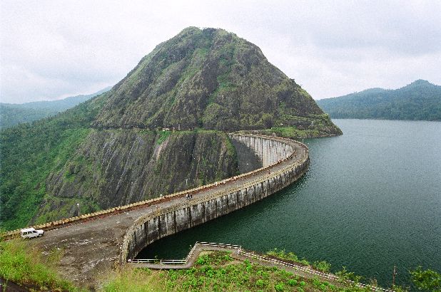
Idukki Dam is a double curvature arch dam on the Periyar in Kerala, India, standing 169 m (554 ft) high and completed in 1976. It carries an installed hydroelectric capacity of 780 MW. The structure impounds Idukki Reservoir.
The Idukki Dam is a double-curvature thin arch dam constructed across the Periyar River in a narrow gorge between two granite hills locally known as Kuravan and Kurathi, in Idukki district, in the state of Kerala, India. It is constructed and owned by the Kerala State Electricity Board. It supports a 780 MW hydroelectric power station in Moolamattom, which started generating power on 4 October 1975. At 168.91 metres (554.2 ft), it is one of the highest arch dams in Asia. The Indo-Canadian project was inaugurated by Prime Minister Indira Gandhi on February 17, 1976.
This dam was constructed along with two other dams at Cheruthoni and Kulamavu. Together, the three dams and Two saddle dams, Kulamavu Saddle Dam (Near Junction) and Kulamavu Saddle Dam (Right Bank) have created an artificial lake that is 60 km2 (23 sq mi) in area. The stored water is used to produce electricity at the Moolamattom Power house, which is located inside nearby rocky caves.
Narakakkanam, Azhutha, Vazhikkadavu, Vadakkepuzha and Kuttiar diversion schemes were later added to augment the Idukki reservoir.
Adapted from Wikipedia: Idukki Dam (CC BY-SA 4.0).
- Dam type
- Double Curvature Arch
- Structural height
- 169 m (554 ft)
- Installed capacity
- 780 MW
- Impounded river
- Periyar
- Reservoir
- Idukki Reservoir
- Location
- Kerala, India
- Year completed
- 1976
- Height rank
- #20 of 115 indexed
- Output rank
- #57 of 102 indexed
- Coordinates
- 9.8511°, 76.9744°
Notable: One of the highest double-curvature arch dams in Asia, built between Kuravan and Kurathi hills.
Among the 115 dams indexed in YearMaps, Idukki Dam ranks #20 by structural height, behind Jinping-I Dam (305 m). By installed generating capacity it ranks #57, behind Three Gorges Dam (22,500 MW).
Nearest cities: Valparai (52 km), Alappuzha (77 km), Rajapalaiyam (82 km).
More about Idukki Dam
History
The idea of constructing a dam for power generation was first conceived in 1919 in a report submitted by Italian engineer Jacob to the Travancore government, which was rejected. As per history, Shri Chemban Karuvellayan Kolumban, the head of 'Oorali' tribe during 1922, showed the way to the Malankara Estate Superintendent W.J.John and his friend AC Thomas Edattu, who were on hunting trip to forests near the present Arch Dam. Upon hearing the legend of Kuravan and Kurathi Hills, Thomas impressed by the sight of water flow between the mountains; suggested the spot suitable for an Arch dam. In 1932, W.J.John submitted a report to the Government of Travancore on the possibility of constructing a dam at Idukki for Power Generation.
Sections adapted from Wikipedia: Idukki Dam (CC BY-SA 4.0).

Cheruthoni Dam
Concrete Gravity dam · Kerala, India
Cheruthoni Dam is a concrete gravity dam on the Periyar / Idukki in Kerala, India, standing 138 m (453 ft) high and completed in 1976. It carries an installed hydroelectric capacity of 780 MW. The structure impounds Idukki Reservoir.
The Cheruthoni Dam, located in Idukki District, Kerala, India, is a 138m tall concrete gravity dam. Preliminary work on this project was initiated under the leadership of Superintending Engineer, E.U.Philipose. This dam was constructed in 1976 as part of the Idukki Hydroelectric Project along with two other dams Idukki and Kulamavu. The Canadian government aided the project with long-term loans and grants. The dam was constructed by HCC (Hindustan Construction Company Ltd.) and the consultant was S.N.C. Inc., Canada,
The water impounded by these three dams of Idukki, Cheruthoni & Kulamavu has formed a single reservoir spread over 60 km2 on a height of 2300 ft above Mean Sea Level. The Idukki Dam is a double curvature arch dam constructed across Periyar River in a narrow gorge between two granite hills and is the tallest double curvature arch dam in Asia. Cheruthoni Dam is located 1 km west of Idukki dam. The spill way of the Idukki Reservoir is in the Cheruthoni dam. Kulamavu Dam was constructed to prevent the water escape through a rivulet called Kilivally, 30 km west to Idukki Arch Dam. It is a 100 metres tall Masonry gravity dam.
Adapted from Wikipedia: Cheruthoni Dam (CC BY-SA 4.0).
- Dam type
- Concrete Gravity
- Structural height
- 138 m (453 ft)
- Installed capacity
- 780 MW
- Impounded river
- Periyar / Idukki
- Reservoir
- Idukki Reservoir
- Location
- Kerala, India
- Year completed
- 1976
- Height rank
- #37 of 115 indexed
- Output rank
- #58 of 102 indexed
- Coordinates
- 9.8500°, 76.9667°
Notable: Forms composite Idukki hydro reservoir alongside Idukki arch dam.
Among the 115 dams indexed in YearMaps, Cheruthoni Dam ranks #37 by structural height, behind Jinping-I Dam (305 m). By installed generating capacity it ranks #58, behind Three Gorges Dam (22,500 MW).
Nearest cities: Valparai (52 km), Alappuzha (76 km), Rajapalaiyam (82 km).

Kulamavu Dam
Concrete Gravity dam · Kerala, India
Kulamavu Dam is a concrete gravity dam on the Periyar / Idukki in Kerala, India, standing 100 m (328 ft) high and completed in 1977. It carries an installed hydroelectric capacity of 780 MW. The structure impounds Idukki Reservoir.
Kulamavu Dam is a gravity/masonry dam on Kilivillithode, which is a tributary of the Periyar river in Arakkulam village, Idukki district in the Indian state of Kerala. It is one of three dams associated with the Idukki hydroelectric power project in the Indian state of Kerala. This dam is located towards the western side of the Idukki Arch Dam. This is a gravity dam with the top portion in concrete and the bottom in masonry.
The dam is situated on the Thodupuzha - Puliyanmala state highway (SH-33), about 23 km (14 mi) from Idukki arch dam, 22 km (14 mi) from Cheruthoni dam and 38 km (24 mi) from Thodupuzha. Preliminary work on the dam was initiated under the leadership of Superintending Engineer, E.U. Philipose. The dam was completed in the year 1977 and is operated and maintained by Kerala State Electricity Board.
The dams of Idukki, Cheruthoni and Kulamavu extend to an area of 33 km2. The construction of these three dams formed a 60 km2 artificial lake. The water stored in it is used for the production of electricity at the power house in Moolamattom.
Adapted from Wikipedia: Kulamavu Dam (CC BY-SA 4.0).
- Dam type
- Concrete Gravity
- Structural height
- 100 m (328 ft)
- Installed capacity
- 780 MW
- Impounded river
- Periyar / Idukki
- Reservoir
- Idukki Reservoir
- Location
- Kerala, India
- Year completed
- 1977
- Height rank
- #50 of 115 indexed
- Output rank
- #59 of 102 indexed
- Coordinates
- 9.8000°, 76.8833°
Notable: Third dam of Idukki hydroelectric trinity, sealing western rim of the reservoir.
Among the 115 dams indexed in YearMaps, Kulamavu Dam ranks #50 by structural height, behind Jinping-I Dam (305 m). By installed generating capacity it ranks #59, behind Three Gorges Dam (22,500 MW).
Nearest cities: Valparai (59 km), Alappuzha (65 km), Kochi (76 km).
Sholayar Dam
Masonry Gravity dam · Kerala / Tamil Nadu, India
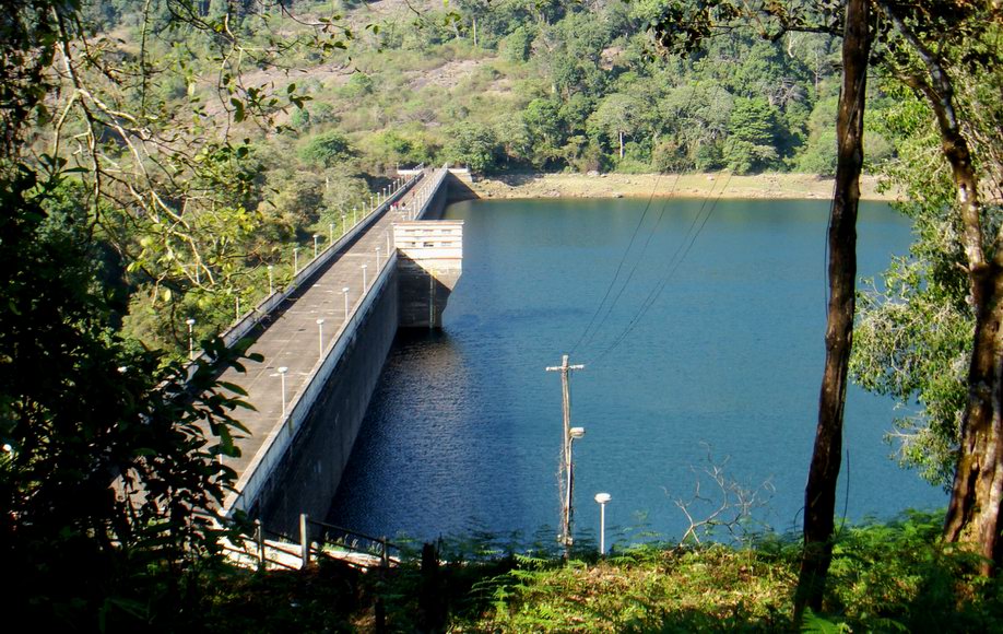
Sholayar Dam is a masonry gravity dam on the Chalakkudy, in the Periyar basin, in Kerala / Tamil Nadu, India, standing 66 m (217 ft) high and completed in 1965. It carries an installed hydroelectric capacity of 54 MW. The structure impounds Upper Sholayar.
Sholayar Dam is a concrete dam built across the Chalakkudi River in Malakkappara in Thrissur district, Kerala of India. The dam consists of main Sholayar Dam, Sholayar Flanking and Sholayar Saddle Dam. It also contains Sholayar Hydro Electric Power Project of KSEB who owns the dam. Total installed capacity of the project is 54MW with 3 penstock pipes. The maximum storage capacity is 2663 feet. Sholayar is 65 km from Chalakudy town. The dam above Sholayar dam is Upper Solaiyar Dam owned by Tamil Nadu.
Adapted from Wikipedia: Sholayar Dam (CC BY-SA 4.0).
- Dam type
- Masonry Gravity
- Structural height
- 66 m (217 ft)
- Installed capacity
- 54 MW
- Impounded river
- Chalakkudy
- River basin
- Periyar
- Reservoir
- Upper Sholayar
- Location
- Kerala / Tamil Nadu, India
- Year completed
- 1965
- Height rank
- #66 of 115 indexed
- Output rank
- #89 of 102 indexed
- Coordinates
- 10.3000°, 76.7500°
Notable: High-altitude dam in the rain-drenched rainforests of the Western Ghats.
Among the 115 dams indexed in YearMaps, Sholayar Dam ranks #66 by structural height, behind Jinping-I Dam (305 m). By installed generating capacity it ranks #89, behind Three Gorges Dam (22,500 MW).
Nearest cities: Valparai (24 km), Kochi (66 km), Coimbatore (81 km).
More about Sholayar Dam
History
Sholayar Dam, Sholayar Saddle Dam and Sholayar Flanking dam are commissioned in 1965. The reservoir has an area of 8.705 square km and the length of the dam is 430.60 metres. The Sholayar Dam has a height of 66 metres and 430 metres width, Sholayar Flanking Dam has a height of 18 metres from the foundation with 109 metres length and Sholayar Saddle has a height of 259 metres and 109 metres width.
Sections adapted from Wikipedia: Sholayar Dam (CC BY-SA 4.0).
Sholayar Dam: Key Facts
| Crest length | 431 m |
|---|---|
| Officially opened | 1965 |
Facts from Wikidata Q17089992 (CC0).

Mullaperiyar Dam
Surkhi / Masonry Gravity dam · Kerala / Tamil Nadu, India
Mullaperiyar Dam is a surkhi / masonry gravity dam on the Periyar in Kerala / Tamil Nadu, India, standing 53.6 m (176 ft) high and completed in 1895. It carries an installed hydroelectric capacity of 140 MW. The structure impounds Periyar Lake.
Mullaperiyar Dam (IPA: [mulːɐpːeɾijɐːr]) is a masonry gravity dam on the Periyar River of Kumily panchayat in Idukki district of Indian state of Kerala. It is situated 150 km south east of Kochi and 200 km north east of state capital city of Trivandrum. It is located 881 m (2,890 ft) above the sea level, on the Cardamom Hills of the Western Ghats in Thekkady, Idukki District of Kerala, India.
It was constructed between 1887 and 1895 by workers under the command of Colonel John Pennycuick, and also reached in an agreement to divert water eastwards to the Madras Presidency area (present-day Tamil Nadu). It has a height of 53.6 m (176 ft) from the foundation, and a length of 365.7 m (1,200 ft). The Periyar National Park in Thekkady is located around the dam's reservoir. The dam is built at the confluence of Mullayar and Periyar rivers. The dam is located in Kerala on the river Periyar, but is operated and maintained by the neighbouring state of Tamil Nadu.
Adapted from Wikipedia: Mullaperiyar Dam (CC BY-SA 4.0).
- Dam type
- Surkhi / Masonry Gravity
- Structural height
- 53.6 m (176 ft)
- Installed capacity
- 140 MW
- Impounded river
- Periyar
- Reservoir
- Periyar Lake
- Location
- Kerala / Tamil Nadu, India
- Year completed
- 1895
- Height rank
- #82 of 115 indexed
- Output rank
- #78 of 102 indexed
- Coordinates
- 9.5294°, 77.1461°
Notable: Historic 1895 lime-surkhi masonry gravity dam engineered by British Major John Pennycuick in Western Ghats.
Among the 115 dams indexed in YearMaps, Mullaperiyar Dam ranks #82 by structural height, behind Jinping-I Dam (305 m). By installed generating capacity it ranks #78, behind Three Gorges Dam (22,500 MW).
Nearest cities: Rajapalaiyam (49 km), Alappuzha (85 km), Valparai (90 km).
More about Mullaperiyar Dam
History
The unique idea of harnessing the westward flowing water of the Periyar river and diverting it to the eastward flowing Vaigai river was first explored in 1789 by Pradani Muthirulappa Pillai, a minister of the Ramnad king Muthuramalinga Sethupathy, who gave it up as he found it to be expensive. The location of the dam had first been scouted by Captain J. L. Caldwell, Madras Engineers (abbreviated as M.E.) in 1808 to reconnoitre the feasibility of providing water from the Periyar river to Madurai by a tunnel through the mountains. Caldwell discovered that the excavation needed would be in excess of 100 feet in depth and the project was abandoned with the comment in his report as "decidedly chimerical and unworthy of any further regard".
Proposal for construction of a new dam and other proposals
In 2014 while passing the final judgement the Supreme Court has laid down criteria for any future construction of new dam downstream and decommissioning of the present Mullaperiyar Dam under the "Way Forward - Towards an amicable solution" or a tunnel solution as suggested by the Empowered Committee (EC). The second tunnel can bring down the water level considerably in the dam and it is as good as decommissioning the dam without hindering supply of water to Tamil Nadu.
The judgement emphasized the suggestion of EC to make a second tunnel at about 50 ft from the bottom so that the large quantity of water, otherwise unused below the current tunnel at 106.5 ft, can be used by Tamil Nadu.
Design
The Mullaperiyar Dam is a gravity dam made with concrete prepared from limestone and "surkhi" (burnt brick powder), and faced with rubble. Gravity dams use their weight and the force of gravity to support the reservoir and remain stable. The main dam has a maximum height of 53.6 m (176 ft) and length of 365.7 m (1,200 ft). Its crest is 3.6 m (12 ft) wide while the base has a width of 42.2 m (138 ft). It consists of a main dam, spillway on its left and an auxiliary dam (or "baby dam") to the right. Its reservoir can withhold 443,230,000 m3 (359,332 acre⋅ft) of water, of which 299,130,000 m3 (242,509 acre⋅ft) is active (live) storage.
Sections adapted from Wikipedia: Mullaperiyar Dam (CC BY-SA 4.0).
Major River Dossiers
Hand-written studies of the great river systems of history.
Connected Reaches
Nearby watercourses in the same drainage network.
Water Bodies in the Catchment
Settlements Along the Reach
Hydraulic Infrastructure Nearby
Surrounding Terrain
Periyar: Quick Answers
- Where is Periyar?
- Periyar is located in India, at 9.8443° N, 76.9676° E.
- Are there dams on the Periyar?
- Yes. YearMaps records 5 dams on the Periyar and its tributaries: Idukki Dam, Cheruthoni Dam, Kulamavu Dam, Sholayar Dam (on the Chalakkudy), Mullaperiyar Dam.
- What is the tallest dam on the Periyar?
- Idukki Dam is the tallest dam recorded on the Periyar, at 169 m (554 ft), completed in 1976.
- Which dam on the Periyar generates the most electricity?
- Idukki Dam has the largest installed hydroelectric capacity on the Periyar: 780 MW. Installed capacity is the maximum rated output, not the annual average.