
Ports & Harbours of the Arabian Sea and the Bay of Bengal
YearMaps maps 62 harbours on the Arabian Sea and the Bay of Bengal, in 9 countries and territories. The largest by the World Port Index's harbour size are Calcutta, Mumbai (Bombay), Chennai (Madras), Chittagong, Karachi and Jawaharlal Nehru Port (Nhava Shiva). 11 are written up in full below, and every harbour is listed with its depths, tidal range and the largest ships it takes.
The Indian subcontinent divides the northern Indian Ocean into the Arabian Sea and the Bay of Bengal, where the monsoon winds set the rhythm of sailing for millennia. Harappan Lothal, Muziris in the Roman era and Mughal Surat traded on the western coast, and the East India Companies founded Bombay, Madras and Calcutta, from which Mumbai, Chennai and Kolkata grew. The harbours of Pakistan, Sri Lanka, Bangladesh and Myanmar are covered here.
- Harbours
- 62
- Countries
- 9
- Large Harbours
- 3
- Written Up
- 11
Map of the Ports of the Arabian Sea and the Bay of Bengal
Blue dots are the harbours of the World Port Index; tap or click one to open its entry. Use the layer panel to add trade routes, rivers and historical borders.
Harbours of the Arabian Sea and the Bay of Bengal in Detail
The 11 harbours of the Arabian Sea and the Bay of Bengal with an encyclopedia article, each with its figures from the World Port Index.
Jawaharlal Nehru Port (Nhava Shiva)
Medium harbour · India
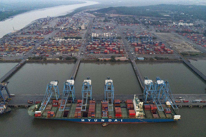
Jawaharlal Nehru Port, also known as JNPT and Nhava Sheva Port, is a large container port in India. Operated by the Jawaharlal Nehru Port Trust Authority (JNPTA), it is located on the eastern shores of Arabian Sea in Navi Mumbai, Raigad district, Maharashtra. This port can be accessed via Uran, a nodal city of Navi Mumbai. It is the main port of the Mumbai Metropolitan Region, also of Maharashtra and Western India. Its common name derives from the names of Nhava and Sheva (new sheva) villages that are situated here. It is also the terminal of the Western Dedicated Freight Corridor.
As of January 2023, the port is undergoing upgrades with the help of a loan agreement signed between the Asian Development Bank (ADB) and Nhava Sheva Freeport Terminal Private Limited (NSFTPL). The loan of $131 million will be used to improve the terminal's infrastructure, increase its container handling capacity, upgrade existing berths and yards, and install energy-efficient equipment. The upgrades aim to attract vessels and make international trade more efficient, transparent and sustainable.
Adapted from Wikipedia: Jawaharlal Nehru Port (CC BY-SA 4.0).
- Harbour size
- Medium
- Channel depth
- 34.7 m
- Anchorage depth
- 31.1 m
- Cargo pier depth
- 31.1 m
- Oil terminal depth
- 31.1 m
- Tidal range
- 4 m
- Largest vessel
- large vessels
- Country
- India
- Province
- Maharashtra
- Coordinates
- 18.9500°, 72.9500°
More about Jawaharlal Nehru Port (Nhava Shiva)
History
The port was established on 26 May 1989 and became the second largest and premier container handling port in India, surpassing the capacity of 4 million TEUs (Twenty-foot equivalent units) in containers between 2016 and 2021.
JNP consists of a full-fledged customs house, 30 container freight stations and connectivity to 52 inland container depots across the country. The hinterland connectivity both by rail and road is being further strengthened by ongoing projects like the Dedicated Freight Corridor (DFC), which will increase the existing train capacity from 27 to 100 trains per day; Multi-Modal Logistics Park (MMLP) and widening of the port's connecting roads.
Sections adapted from Wikipedia: Jawaharlal Nehru Port (CC BY-SA 4.0).
Jawaharlal Nehru Port (Nhava Shiva): Key Facts
| On | Indian Ocean |
|---|
Facts from Wikidata Q1984452 (CC0).

Mongla
Small harbour · Bangladesh
The Port of Mongla is a Bangladeshi seaport, located at Mongla, Khulna Division.It is located near the north shore of the Bay of Bengal. It is the second largest and busiest seaport of Bangladesh after the Port of Chittagong. The Mongla port lies close to the shore of the Bay of Bengal, Pashur river and the divisional city of Khulna. It is also connected by rail with Khulna. Additionally, an airport had been planned and authorized near the post area named Khan Jahan Ali Airport; however the construction has stalled in the last few years. Mongla was renowned historically among the major important ports of the Bengal delta. Due to the increasing congestion in Bangladesh's largest port of Chittagong, many international shipping companies have turned to Mongla as an alternative. Also the continuous demand from all over the country and neighboring countries has made it busier and economically attractive.
Also political and economical influence in Khulna region from the government has also added to the development and demand of the port of Mongla. Padma Bridge mega-project is a big example of such influence in Khulna region.
Adapted from Wikipedia: Port of Mongla (CC BY-SA 4.0).
- Harbour size
- Small
- Channel depth
- 49.4 m
- Anchorage depth
- 45.7 m
- Cargo pier depth
- 49.4 m
- Tidal range
- 3 m
- Largest vessel
- medium vessels
- Country
- Bangladesh
- Coordinates
- 22.4700°, 89.6000°
More about Mongla
Geography
It was formerly located at Chalna, about 18 kilometres (11 mi) upstream on the Pasur River but it is now located 48 km south of Khulna city, as established on 11 December 1954. The Port is surrounded and protected by the Sundarban mangrove forest. The port is situated at the confluence of the Pasur River and the Mongla River. It lies about 100 km (62 mi) north of the Bay of Bengal.
Sections adapted from Wikipedia: Port of Mongla (CC BY-SA 4.0).

Kandla
Small harbour · India
Kandla Port, officially known as Deendayal Port, is a seaport in the Kutch district of Gujarat, India. The port is situated in the Kandla Creek and is 90 km from the mouth of Gulf of Kutch.It is one of India’s major ports on the west coast. The port is about 256 nautical miles southeast of the Port of Karachi in Pakistan and about 430 nautical miles north-northwest of the Port of Mumbai. Kandla Port was constructed in the 1950s as the chief seaport serving western India.
The depth of the port channel depends on the tide. This channel has a minimum depth of 13 meters. It is the largest port of India by volume of cargo handled. Kandla Port was renamed as Deendayal Port in 2017 under the Indian Ports Act, 1908.
The Kandla Port is one of the ports that support the hinterland of North, West, and Central India. It mainly transports liquid and bulk cargoes and handled 132.3 million metric tonnes of cargo in the 2023–24 financial year.
Adapted from Wikipedia: Kandla Port (CC BY-SA 4.0).
- Harbour size
- Small
- Channel depth
- 34.7 m
- Anchorage depth
- 34.7 m
- Cargo pier depth
- 34.7 m
- Oil terminal depth
- 34.7 m
- Tidal range
- 6 m
- Largest vessel
- large vessels
- Country
- India
- Province
- Gujarat
- Coordinates
- 23.0300°, 70.2200°
More about Kandla
History and Location
Kandla was constructed in the 1950s as the chief seaport serving western India, after the independence of India.
The Port of Deendayal is located on the Gulf of Kutch on the northwestern coast of India, some 256 nautical miles southeast of the Port of Karachi in Pakistan and over 430 nautical miles north-northwest of the Port of Mumbai (Bombay). The port infrastructure of the Deendayal Port Authority is located at three different locations along the Gulf of Kutch, which are Kandla Creek, Tuna Tekra and Vadinar. The port is located 90 miles (140 km) from the Gulf of Kutch estuary or the Arabian Sea.
The substrata of the port area consists of silty clay up to a depth of 10 metres (33 ft) below seabed, followed by hard silt up to 26 m; Dense sands are observed underneath the hard silt.
Sections adapted from Wikipedia: Kandla Port (CC BY-SA 4.0).
Hazira
Small harbour · India
Hazira Port or Surat Port is a deep-water liquefied natural gas (LNG) terminal and multi-cargo deep-water port about 20 miles southwest of Surat, India built by Essar Group. It was originally designed as a captive port for Essar Steel. The current container port has been acquired by Adani Group. The LNG facility is a joint venture between Shell Gas B.V (Shell) and Total Gaz Electricité Holdings France (Total). Shell has 74% stake in the venture, with Total holding the remainder.
Adapted from Wikipedia: Hazira Port (CC BY-SA 4.0).
- Harbour size
- Small
- Channel depth
- 31.1 m
- Anchorage depth
- 34.7 m
- Cargo pier depth
- 31.1 m
- Oil terminal depth
- 31.1 m
- Tidal range
- 7 m
- Largest vessel
- large vessels
- Country
- India
- Province
- Gujarat
- Coordinates
- 21.0800°, 72.6300°
More about Hazira

Paradip
Small harbour · India
Paradip Port is a natural, deep-water port on the East coast of India in Paradip, just 53 km (33 mi) from Jagatsinghpur city in Jagatsinghpur district of Odisha, India. It is at the confluence of the Mahanadi river and the Bay of Bengal, 210 nmi (390 km; 240 mi) south of Kolkata and 260 nmi (480 km; 300 mi) north of Visakhapatnam.
The port have dry and breakbulk cargo handling terminal, oil jetty, and Single point mooring terminals. It primarily handles Panamax-sized–carriers of 60,000–80,000 deadweight tonnage (DWT)–vessels; however, the port has the ability to handle vessels of over 100,000 deadweight tonnage. It has a maximum draft depth of 16 metres (52 ft), and enabled to handle Capesize vessels up to 300 metres (980 ft) long (Beam 48 metres (157 ft) and 1,18,000 DWT) with a maximum draft of 14.5 metres (48 ft). This Port has single point moorings, which are located in deep water about 20 kilometres (12 mi) from the coast.
The Paradip Port support the hinterland of Central and East India. It mainly transports bulk cargoes and crude oil; handled 150.41 million metric tonnes of cargoes in the 2024–25 financial year.
Adapted from Wikipedia: Paradip Port (CC BY-SA 4.0).
- Harbour size
- Small
- Channel depth
- 31.1 m
- Anchorage depth
- 38.4 m
- Cargo pier depth
- 34.7 m
- Oil terminal depth
- 27.4 m
- Tidal range
- 2 m
- Largest vessel
- medium vessels
- Country
- India
- Province
- Odisha
- Coordinates
- 20.2700°, 86.6800°
More about Paradip
History
Paradip is one of the major ports of India and the only major port in Odisha. Biju Patnaik, the then Chief Minister of Odisha, is the founding father of Paradip Port. It is situated 210 nautical miles south of Kolkata and 260 nautical miles north of Vishakhapatnam on the east coast on the shore of Bay of Bengal.
Jawaharlal Nehru, the then Prime Minister of India, laid the foundation stone of the port on 3 January 1962 near the confluence of the river Mahanadi and the Bay of Bengal.
Government of India took over the management of the port from the Government of Odisha on 1 June 1965. Maiden berthing was by INS Investigator on 12 March 1966. The port was declared open by Peter Stambolic, the Prime Minister of Yugoslavia on the same day.
Sections adapted from Wikipedia: Paradip Port (CC BY-SA 4.0).
Paradip: Key Facts
| Established | 12 March 1966 |
|---|---|
| On | Indian Ocean |
Facts from Wikidata Q7134171 (CC0).
Kamarajar Port
Small harbour · India
Kamarajar Port, also known as Ennore Port, is located on the Coromandel Coast, Chennai about 18 km north of Chennai Port. It is the 12th major port of India, and the first port in India which is a public company. The Kamarajar Port Limited is the only corporatised major port and is registered as a company. Chennai Port Trust acquired around 67% stake of Centre in the Kamarajar Port Limited on 27 March 2020. The remaining 23 percent was already held by the Chennai Port Trust.
The port has been able to attract an investment of ₹26,000 million by private entrepreneurs on various terminals and harbour craft. Kamarajar Port Limited, designed as Asia's energy port, is the first corporatised port in India and has only 86 employees. Envisaged being a satellite port to decongest and improve the environmental quality at the bustling Chennai Port, Kamarajar Port Limited is evolving itself into a full-fledged port with the capacity to handle a wide range of products. With a permissible draught of 13.5 m, the port handled a total volume of 11.01 million tonnes in 2010–11, up by 2.86 per cent from the previous year.
Adapted from Wikipedia: Kamarajar Port (CC BY-SA 4.0).
- Harbour size
- Small
- Channel depth
- 23.8 m
- Anchorage depth
- 23.8 m
- Cargo pier depth
- 31.1 m
- Oil terminal depth
- 27.4 m
- Tidal range
- 1 m
- Largest vessel
- medium vessels
- Country
- India
- Province
- Tamil Nadu
- Coordinates
- 13.2700°, 80.3200°
More about Kamarajar Port
History
Ennore Port was originally conceived as a satellite port to the Chennai Port, primarily to handle thermal coal to meet the requirement of Tamil Nadu Electricity Board (TNEB), and was endowed with large chunks of land (about 2,000 acres). The scope was expanded taking into account subsequent developments such as the plan of Government of Tamil Nadu to set up a 1,880 mW LNG power project in association with a private consortium, a large petrochemical park and a naphtha cracker plant. Ennore Port was commissioned by the then Prime Minister of India Atal Bihari Vajpayee on 1 February 2001. The port was set up under the Companies Act, keeping it outside the scope of the Tariff Authority for Major Ports, the tariff regulator for 11 of the 12 ports owned by the Indian government.
Location and geography
Ennore Port lies on the northeastern corner of the Chennai City of Tamil Nadu State on a flat coastal plain known as the Eastern Coastal Plains. It is located on the east coast of the Indian peninsula known as the Coromandel Coast in the Bay of Bengal and is situated 2.6 km north of the Ennore Creek. Nearby railway station is Athipattu Pudunagar. Being coastal and situated on the thermal equator zone, the port experiences minimal variations in seasonal temperature ranging from a maximum of 38–42 °C in summer to a minimum of 18–20 °C in winter. The weather is hot and humid for most of the year, and the region features a tropical wet and dry climate. The northeast monsoon winds brings seasonal rainfall in the region from September to December, and occasionally cyclones.
Operations
Commissioned in 2001 and operating on a landlord port concept, it is outsourcing all services required for operation and maintenance, and new terminals are being developed with the participation of the private sector. During the year of 2010–11, it handled a total cargo of 11.01 million tons. The port has effectively taken over all the ore movement from the Chennai Port. By 2016, the port is expected to have the capacity to handle over 80 million tons of cargo and its coal-handling capacity is expected to be about 43 million tons.
Sections adapted from Wikipedia: Kamarajar Port (CC BY-SA 4.0).
Kamarajar Port: Key Facts
| On | Indian Ocean |
|---|
Facts from Wikidata Q10986919 (CC0).

Karaikal Port
Small harbour · India
Karaikal Port Private Limited (KPPL; French: Port de Karaikal SARL) a private port developed by the Chennai based MARG Limited, became operational in April, 2009. It is located on the Eastern coast of India in Karaikal around 300 km south of Chennai Port and around 360 km north of Tuticorin Port.
On April 1, 2023, Adani Ports & SEZ (APSEZ) completed the acquisition of Karaikal Port.
Adapted from Wikipedia: Karaikal Port (CC BY-SA 4.0).
- Harbour size
- Small
- Channel depth
- 23.8 m
- Anchorage depth
- 34.7 m
- Cargo pier depth
- 27.4 m
- Tidal range
- 1 m
- Largest vessel
- large vessels
- Country
- India
- Province
- Puducherry
- Coordinates
- 10.8300°, 79.8700°
More about Karaikal Port
Overview
Karaikal Port project began with a Letter of Interest issued by Govt. of Pondicherry for development of a port at Karaikal in September 2005. MARG Ltd. signed the concession agreement in 2006 and work began in February, 2007. Phase 1 was envisaged to be operational in Aug 2009.
Karaikal Port became operational in April 2009 when it received its first vessel. Phase 1 comprises 2 Panamax size berths capable of handling 5.2 million MT of cargo per annum. The port has received over 1655 vessels since Commercial Operations and has handled over 55 million MT of various cargo.
KPPL has partners in Ocean Sparkle (marine operations) and PSTS (Stevedoring). Cargo evacuation is assisted by MARG Logistics, a sister concern of KPPL.
Sections adapted from Wikipedia: Karaikal Port (CC BY-SA 4.0).
Karaikal Port: Key Facts
| Established | 2005 |
|---|---|
| On | Indian Ocean |
Facts from Wikidata Q6367985 (CC0).

Mundra
Small harbour · India
Mundra Port is the largest commercial and container port in India, located on the northern shores of the Gulf of Kutch near Mundra, Kutch district, Gujarat. It is India's first private port, formerly operated by Mundra Port and Special Economic Zone Limited (MPSEZ) under the ownership of the Adani Group. It was later expanded to become Adani Ports & SEZ Limited (APSEZ), managing several port projects. In FY 2020–21, Mundra Port handled 144.4 million tonnes of cargo. The port currently handles over 155 MT, the highest in India, which constitutes nearly 11 per cent of India’s total annual maritime cargo. The port also handles nearly 33 per cent of India’s container traffic.
Adapted from Wikipedia: Mundra Port (CC BY-SA 4.0).
- Harbour size
- Small
- Channel depth
- 20.1 m
- Anchorage depth
- 34.7 m
- Cargo pier depth
- 23.8 m
- Oil terminal depth
- 5.5 m
- Tidal range
- 5 m
- Largest vessel
- large vessels
- Country
- India
- Province
- Gujarat
- Coordinates
- 22.7300°, 69.7000°
More about Mundra
History
The Port of Mundra is a private port and is also a special economic zone. Incorporated in 1998 as Gujarat Adani Port Limited (GAPL), the company began operating in 2001. The combined company was renamed Mundra Port and Special Economic Zone Limited.It was financed by IFCI.
In 1994, the Gujarat Maritime Board (GMB) approved setting up a captive jetty at the Port of Mundra. In 1998, a joint-sector company, the Gujarat Adani Port Ltd., was incorporated and multi-purpose berths 1 and 2 at Terminal I began operating. MT Alpha-2, a small tanker was the first ship anchored on 7 October 1998. In 1999, multi-purpose berths 3 and 4 opened at Terminal I.
In 2001, the Port of Mundra signed a concession agreement with GMB for development, operation, and maintenance of the port at Mundra.
Sections adapted from Wikipedia: Mundra Port (CC BY-SA 4.0).
Mundra: Key Facts
| Operator | Adani Ports & SEZ |
|---|---|
| On | Indian Ocean |
Facts from Wikidata Q20650238 (CC0).

Magdalla
Very Small harbour · India
The Port of Magdalla is a port in western India, located on the southern bank of the Tapi River, around 10 km from Surat. It is operated by Gujarat Maritime Board.
Adapted from Wikipedia: Port of Magdalla (CC BY-SA 4.0).
- Harbour size
- Very Small
- Channel depth
- 45.7 m
- Anchorage depth
- 34.7 m
- Cargo pier depth
- 53 m
- Tidal range
- 5 m
- Largest vessel
- medium vessels
- Country
- India
- Coordinates
- 21.1500°, 72.7500°
More about Magdalla
Navlakhi
Very Small harbour · India
Navlakhi Port is an all-weather lighterage non-major intermediate port on the southwest end of the Gulf of Kutch in Hansthal Creek, India. The port is about 45 km from Morbi and 160 km from Kandla. Navigation is permitted only during daylight hours; boats use channel buoys for navigation. The port unloads 8,000 to 9,000 MT of coal per day. It is governed by the Gujarat Maritime Board. The nearest airports are in Rajkot (120 km) and Jamnagar (135 km).
Adapted from Wikipedia: Port of Navlakhi (CC BY-SA 4.0).
- Harbour size
- Very Small
- Channel depth
- 34.7 m
- Anchorage depth
- 34.7 m
- Tidal range
- 6 m
- Largest vessel
- large vessels
- Country
- India
- Province
- Gujarat
- Coordinates
- 22.9500°, 70.4500°
More about Navlakhi
Dahej
Very Small harbour · India
Dahej is a cargo port situated on the South-west coast of Gujarat, India in Bharuch district. There is 17.5 million tonnes per year capacity LNG terminal operated by Petronet in Dahej.
Adapted from Wikipedia: Dahej Port (CC BY-SA 4.0).
- Harbour size
- Very Small
- Channel depth
- 27.4 m
- Anchorage depth
- 16.5 m
- Cargo pier depth
- 27.4 m
- Oil terminal depth
- 31.1 m
- Tidal range
- 7 m
- Largest vessel
- large vessels
- Country
- India
- Province
- Gujarat
- Coordinates
- 21.7000°, 72.5300°
More about Dahej
All Harbours of the Arabian Sea and the Bay of Bengal
62 harbours, the largest first by the index's harbour size. Channel depth and tidal range set the physical limit on which ships can call. 30 of them are recorded in the source with the city they serve.
| Harbour | Country | Size | Channel | Anchorage | Tide | Largest vessel | Map |
|---|---|---|---|---|---|---|---|
| Calcuttaserves Haora | India | Major | 42.1 m | — | 2 m | medium vessels | |
| Mumbai (Bombay)serves Mumbai | India | Major | 34.7 m | — | 4 m | large vessels | |
| Chennai (Madras)serves Chennai | India | Major | 16.5 m | — | 1 m | medium vessels | |
| Chittagong | Bangladesh | Medium | 49.4 m | — | 3 m | medium vessels | |
| Karachi | Pakistan | Medium | 38.4 m | — | 2 m | large vessels | |
| Jawaharlal Nehru Port (Nhava Shiva) | India | Medium | 34.7 m | 31.1 m | 4 m | large vessels | |
| Colombo | Sri Lanka | Medium | 31.1 m | — | 1 m | medium vessels | |
| Gwadar | Pakistan | Medium | 31.1 m | — | 2 m | medium vessels | |
| Kochi (Cochin)serves Kochi | India | Medium | 27.4 m | — | 1 m | large vessels | |
| New Mangaloreserves Mangalore | India | Medium | 27.4 m | — | 2 m | large vessels | |
| Moulmein Harborserves Mawlamyine | Myanmar | Small | 56.7 m | — | — | medium vessels | |
| Bhavnagar | India | Small | 53 m | — | 12 m | medium vessels | |
| Port Blair | India | Small | 53 m | — | 3 m | medium vessels | |
| Basseinserves Pathein | Myanmar | Small | 49.4 m | — | 2 m | medium vessels | |
| Merguiserves Myeik | Myanmar | Small | 49.4 m | — | 12 m | medium vessels | |
| Mongla | Bangladesh | Small | 49.4 m | 45.7 m | 3 m | medium vessels | |
| Sittwe | Myanmar | Small | 49.4 m | — | 2 m | medium vessels | |
| Galle Harborserves Galle | Sri Lanka | Small | 38.4 m | — | 1 m | medium vessels | |
| Kandla | India | Small | 34.7 m | 34.7 m | 6 m | large vessels | |
| Muhamamad Bin Qasim | Pakistan | Small | 34.7 m | 34.7 m | 3 m | medium vessels | |
| Hazira | India | Small | 31.1 m | 34.7 m | 7 m | large vessels | |
| Paradip | India | Small | 31.1 m | 38.4 m | 2 m | medium vessels | |
| Tuticorin | India | Small | 31.1 m | — | 1 m | medium vessels | |
| Nagappattinam | India | Small | 27.4 m | 27.4 m | — | large vessels | |
| Pipavav Bandar | India | Small | 27.4 m | 42.1 m | 3 m | large vessels | |
| Kamarajar Port | India | Small | 23.8 m | 23.8 m | 1 m | medium vessels | |
| Karaikal Port | India | Small | 23.8 m | 34.7 m | 1 m | large vessels | |
| Mina Raysut | Oman | Small | 23.8 m | 38.4 m | 2 m | large vessels | |
| Mundra | India | Small | 20.1 m | 34.7 m | 5 m | large vessels | |
| Gopalpur | India | Small | — | — | — | — | |
| Rangoon | Myanmar | Small | — | — | 2 m | medium vessels | |
| Azhikal (Azhikkal) | India | Very Small | 56.7 m | 42.1 m | — | medium vessels | |
| Cuddalore | India | Very Small | 56.7 m | — | — | large vessels | |
| Beypore | India | Very Small | 53 m | 38.4 m | 1 m | medium vessels | |
| Panaji | India | Very Small | 53 m | — | 2 m | medium vessels | |
| Belekeri | India | Very Small | 49.4 m | 38.4 m | — | medium vessels | |
| Magdalla | India | Very Small | 45.7 m | 34.7 m | 5 m | medium vessels | |
| Haldia Portserves Haldia | India | Very Small | 42.1 m | — | 3 m | large vessels | |
| Mandvi | India | Very Small | 42.1 m | 45.7 m | 3 m | large vessels | |
| Okha | India | Very Small | 42.1 m | 42.1 m | 3 m | large vessels | |
| Quilon (Kollam)serves Kollam | India | Very Small | 42.1 m | — | 1 m | medium vessels | |
| Uleelheueserves Banda Aceh | Indonesia | Very Small | 42.1 m | — | 2 m | medium vessels | |
| Kankesanturai | Sri Lanka | Very Small | 38.4 m | 38.4 m | 2 m | medium vessels | |
| Karwar | India | Very Small | 38.4 m | 45.7 m | 2 m | large vessels | |
| Ratnagiri | India | Very Small | 38.4 m | 38.4 m | 3 m | large vessels | |
| Veraval | India | Very Small | 38.4 m | 31.1 m | 2 m | large vessels | |
| Navlakhi | India | Very Small | 34.7 m | 34.7 m | 6 m | large vessels | |
| Pondicherry | India | Very Small | 34.7 m | — | 1 m | large vessels | |
| Porbandar | India | Very Small | 31.1 m | — | 2 m | large vessels | |
| Bedi | India | Very Small | 27.4 m | 27.4 m | 5 m | large vessels | |
| Dahej | India | Very Small | 27.4 m | 16.5 m | 7 m | large vessels | |
| Machilipatnam | India | Very Small | 27.4 m | — | 1 m | medium vessels | |
| Trivandrumserves Thiruvananthapuram | India | Very Small | 20.1 m | — | 1 m | medium vessels | |
| Sabang | Indonesia | Very Small | 9.1 m | 9.1 m | 1 m | large vessels | |
| Maleserves Malé | Maldives | Very Small | 5.5 m | — | 1 m | medium vessels | |
| Sikka | India | Very Small | 5.5 m | 27.4 m | 5 m | large vessels | |
| Vadinar Terminal | India | Very Small | 5.5 m | 20.1 m | 6 m | large vessels | |
| Yetagun Marine Terminal | Myanmar | Very Small | 5.5 m | — | 1 m | — | |
| Calicut (Kozhikode)serves Kozhikode | India | Very Small | — | — | 1 m | medium vessels | |
| Kakinada Bayserves Kakinada | India | Very Small | — | — | 2 m | large vessels | |
| Kolachel | India | Very Small | — | 31.1 m | 1 m | medium vessels | |
| Nishtun | Yemen | Very Small | — | 38.4 m | 1 m | medium vessels |
Port Cities of the Arabian Sea and the Bay of Bengal
The most populous cities with a harbour of the Arabian Sea and the Bay of Bengal within 25 km. Each city is listed with its country's other cities on the country page.
- Mumbai18.98 million
India · Mumbai (Bombay), Jawaharlal Nehru Port (Nhava Shiva) (13 km)
- Kolkata14.79 million
India · Calcutta (9 km)
- Karachi12.13 million
Pakistan · Karachi
- Chennai7.16 million
India · Chennai (Madras), Kamarajar Port (20 km)
- Haora4.84 million
India · Calcutta
- Chittagong4.53 million
Bangladesh · Chittagong
- Rangoon4.09 million
Capital of Myanmar · Rangoon
- Surat3.84 million
- Kochi1.52 million
India · Kochi (Cochin)
- Thiruvananthapuram954,000
India · Trivandrum
- Kozhikode953,000
India · Beypore (10 km), Calicut (Kozhikode)
- Mangalore776,632
India · New Mangalore
- Bhavnagar554,978
India · Bhavnagar
- Banda Aceh513,698
Indonesia · Uleelheue
- Mawlamyine438,861
Myanmar · Moulmein Harbor
- Tuticorin436,094
India · Tuticorin
- Kollam394,163
India · Quilon (Kollam)
- Brahmapur324,726
India · Gopalpur (15 km)
- Kakinada292,923
India · Kakinada Bay
- Myeik266,720
Myanmar · Mergui
- Jaffna250,000
Sri Lanka · Kankesanturai (17 km)
- Pathein237,089
Myanmar · Bassein
- Porbandar234,684
India · Porbandar
- Pondicherry227,411
India · Cuddalore (25 km), Pondicherry
- Nagercoil224,329
India · Kolachel (20 km)
- Colombo217,000
Capital of Sri Lanka · Colombo
- Salalah203,877
Oman · Mina Raysut (13 km)
- Haldia200,762
India · Haldia Port
- Moratuwa200,000
Sri Lanka · Colombo (17 km)
- Machilipatnam192,827
India · Machilipatnam
Countries with Harbours on the Arabian Sea and the Bay of Bengal
More Seas and Coasts
- Ports of Strait of Malacca & Singapore
- Ports of South China Sea & Gulf of Thailand
- Ports of Java Sea & Indonesian Archipelago
- Ports of Philippine, Sulu & Celebes Seas
- Ports of Yellow Sea & East China Sea
- Ports of Sea of Japan & Sea of Okhotsk
- Ports of Seto Inland Sea
- Ports of Pacific Coast of Japan
See every sea, grouped from North America to Oceania & Antarctica, on the world ports index, or the voyages that crossed these waters on the famous sea voyages map.
Arabian Sea & Bay of Bengal: Quick Answers
- How many ports are there on the Arabian Sea and the Bay of Bengal?
- YearMaps lists 62 ports and harbours on the Arabian Sea and the Bay of Bengal, from the World Port Index of the US National Geospatial-Intelligence Agency. Small fishing harbours and private terminals outside the index are not counted.
- Which countries have ports on the Arabian Sea and the Bay of Bengal?
- India (43), Myanmar (6), Pakistan (3), Sri Lanka (3), Bangladesh (2), Indonesia (2), Maldives (1), Oman (1) and Yemen (1).
- What are the largest ports on the Arabian Sea and the Bay of Bengal?
- By the World Port Index's harbour size, the largest are Calcutta, Mumbai (Bombay), Chennai (Madras), Chittagong, Karachi and Jawaharlal Nehru Port (Nhava Shiva).
- What are the main port cities on the Arabian Sea and the Bay of Bengal?
- The most populous cities with a harbour here are Mumbai (18.98 million), Kolkata (14.79 million), Karachi (12.13 million), Chennai (7.16 million) and Haora (4.84 million).