
Paleozoic Era · Cambrian Period
Earth 500 Million Years Ago: The Cambrian Seas
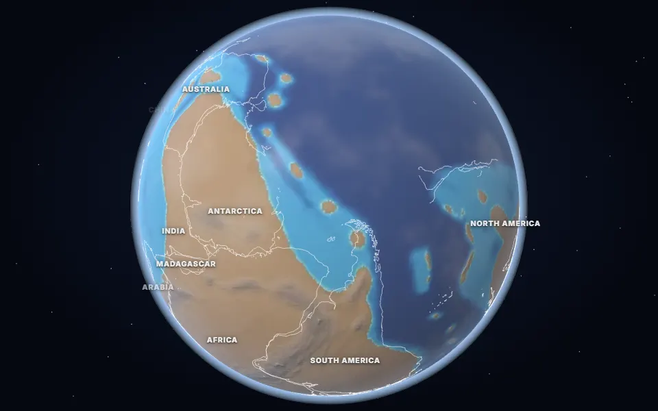
What Earth looked like 500 million years ago: warm shallow seas full of trilobites, bare continents and Gondwana spread across the south.
 Spin it in 3D and move through time
Map: Ancient maps: PALEOMAP PaleoDEMs (Scotese & Wright 2018), CC BY 4.0 · Natural Earth.
500 million years ago, in the late Cambrian, the world was warm and sea levels were high. Shallow seas covered much of North America, Siberia and the edges of Gondwana, and they teemed with trilobites, brachiopods and early relatives of today’s animal groups.
On land there was still nothing green. The first animals to venture out may have been arthropods leaving trackways on coastal sand, found in Cambrian rocks of Quebec and Ontario.
Gondwana stretched from the equator to the South Pole. Laurentia sat on the equator, while the Iapetus Ocean separated it from Baltica and from Avalonia, a strip of land that would later become parts of England, Newfoundland and New England.
Events of the time
Ediacara fossils
555 million years ago · Ediacara Hills, Australia
Imprints of soft-bodied animals such as Dickinsonia, now known to be an animal from the fats preserved in it.
Chengjiang fossils
518 million years ago · Yunnan, China
Soft-bodied animals preserved in fine mud, including some of the earliest relatives of vertebrates: a snapshot of the Cambrian explosion.
Burgess Shale
508 million years ago · British Columbia, Canada
A Cambrian sea floor with strange animals such as five-eyed Opabinia and the predator Anomalocaris, then near the equator.
Ice sheet over the Sahara
445 million years ago · North Africa
Scratched rock and glacial deposits in the Sahara show that ice covered North Africa when it lay over the South Pole. The cold and falling seas killed about 85% of marine species.
Which land was under the sea 500 million years ago?
On the map nearest this age (500 million years ago, late Middle Cambrian), about 39% of today’s land was under the sea at some point, some 55.7 million km². That makes it number 18 of the 80 maps from 535 to 5 million years ago, which run from 2% to 50%. Each map shows the greatest flooding of its stage, so no single moment had quite this much sea.
- Sauk Sea
Cambrian to Early Ordovician (approximate) · The centre of North America: the Great Plains, the Midwest and the Great Lakes
The first great flood over North America’s interior, named after the Sauk sequence of rock layers. Its sandstones and limestones lie under much of the Midwest, and trilobites were its best-known animals.
Was it under the sea? 23 of 42 cities
| Place today | 500 million years ago |
|---|---|
| Alice Springs, Australia | Shallow sea |
| Bangkok, Thailand | Shallow sea |
| Beijing, China | Shallow sea |
| Bismarck, United States | Shallow sea |
| Calgary, Canada | Shallow sea |
| Casper, Wyoming, United States | Shallow sea |
| Chicago, United States | Shallow sea |
| Dallas, United States | Shallow sea |
| Delhi, India | Shallow sea |
| Denver, United States | Shallow sea |
| Hays, Kansas, United States | Shallow sea |
| Kansas City, United States | Shallow sea |
| Madrid, Spain | Shallow sea |
| Mexico City, Mexico | Shallow sea |
| New York, United States | Shallow sea |
| Novosibirsk, Russia | Shallow sea |
| Paris, France | Shallow sea |
| Regina, Canada | Shallow sea |
| Richmond, Queensland, Australia | Shallow sea |
| Riyadh, Saudi Arabia | Shallow sea |
| Salt Lake City, United States | Shallow sea |
| Tehran, Iran | Shallow sea |
| Warsaw, Poland | Shallow sea |
| Almaty, Kazakhstan | Not modelled |
| Baku, Azerbaijan | Not modelled |
| Berlin, Germany | Land |
| Budapest, Hungary | Not modelled |
| Cairo, Egypt | Land |
| Hannover, Germany | Land |
| Johannesburg, South Africa | Land |
| Kathmandu, Nepal | Land |
| London, United Kingdom | Land |
| Montgomery, Alabama, United States | Land |
| Moscow, Russia | Land |
| Nairobi, Kenya | Land |
| Niamey, Niger | Land |
| Perth, Australia | Land |
| Rome, Italy | Land |
| São Paulo, Brazil | Land |
| Timbuktu, Mali | Land |
| Vienna, Austria | Land |
| Winnipeg, Canada | Land |
1,303 marine fossil sites in the Paleobiology Database are dated closely enough to this map. Of those on today’s land, 99% fall in its shaded sea.
Seas: Ancient seas: PaleoCoastlines v7 (Kocsis & Scotese 2021), CC BY 4.0 · Fossils: Paleobiology Database.
Part of the Paleozoic Era & The Cambrian Explosion.