
Paleozoic Era · Devonian Period
Earth 400 Million Years Ago: The Age of Fishes
What Earth looked like 400 million years ago in the Devonian: the Age of Fishes, the first insects, and plants spreading over the land.
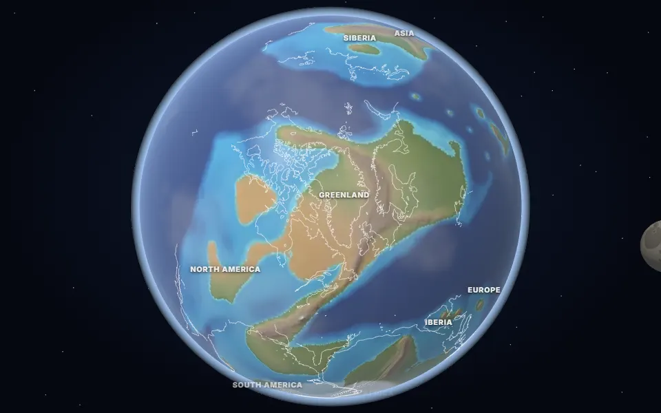 Spin it in 3D and move through time
Map: Ancient maps: PALEOMAP PaleoDEMs (Scotese & Wright 2018), CC BY 4.0 · Natural Earth.
The Devonian is called the Age of Fishes: armoured placoderms, sharks and lobe-finned fish filled the seas and rivers. Some lobe-finned fish were the ancestors of the first four-legged animals, which appeared by about 375 million years ago.
On land, plants with veins to carry water were spreading inland. The Rhynie chert of Scotland, about 407 million years old, preserves one of these early ecosystems in detail, with plants, fungi and some of the first insects and spiders.
North America and northern Europe had joined into Laurussia, the “Old Red Sandstone continent”, along the Caledonian mountains. Gondwana still lay to the south across the narrowing Rheic Ocean.
Events of the time
Ice sheet over the Sahara
445 million years ago · North Africa
Scratched rock and glacial deposits in the Sahara show that ice covered North Africa when it lay over the South Pole. The cold and falling seas killed about 85% of marine species.
Gilboa fossil forest
385 million years ago · New York, USA
Stumps of some of the earliest known trees, about 8 m tall, which had fronds instead of leaves.
Which land was under the sea 400 million years ago?
On the map nearest this age (400 million years ago, Early Devonian), about 46% of today’s land was under the sea at some point, some 66.0 million km². That makes it number 4 of the 80 maps from 535 to 5 million years ago, which run from 2% to 50%. Each map shows the greatest flooding of its stage, so no single moment had quite this much sea.
- Kaskaskia Sea
Devonian to Mississippian (approximate) · Much of the United States and southern Canada
The third flood over North America’s interior, named after the Kaskaskia sequence of rock layers. Its warm, shallow water built reefs of coral and left the limestones of Indiana and Kentucky.
Was it under the sea? 26 of 42 cities
| Place today | 400 million years ago |
|---|---|
| Almaty, Kazakhstan | Shallow sea |
| Bangkok, Thailand | Shallow sea |
| Bismarck, United States | Shallow sea |
| Cairo, Egypt | Shallow sea |
| Calgary, Canada | Shallow sea |
| Chicago, United States | Shallow sea |
| Dallas, United States | Shallow sea |
| Delhi, India | Shallow sea |
| Denver, United States | Shallow sea |
| Kansas City, United States | Shallow sea |
| Kathmandu, Nepal | Shallow sea |
| London, United Kingdom | Shallow sea |
| Madrid, Spain | Shallow sea |
| Mexico City, Mexico | Shallow sea |
| Montgomery, Alabama, United States | Shallow sea |
| Novosibirsk, Russia | Shallow sea |
| Paris, France | Deep ocean |
| Perth, Australia | Shallow sea |
| Regina, Canada | Shallow sea |
| Richmond, Queensland, Australia | Shallow sea |
| Rome, Italy | Shallow sea |
| Salt Lake City, United States | Shallow sea |
| São Paulo, Brazil | Shallow sea |
| Tehran, Iran | Shallow sea |
| Vienna, Austria | Shallow sea |
| Winnipeg, Canada | Shallow sea |
| Alice Springs, Australia | Land |
| Baku, Azerbaijan | Not modelled |
| Beijing, China | Land |
| Berlin, Germany | Land |
| Budapest, Hungary | Not modelled |
| Casper, Wyoming, United States | Land |
| Hannover, Germany | Land |
| Hays, Kansas, United States | Land |
| Johannesburg, South Africa | Land |
| Moscow, Russia | Land |
| Nairobi, Kenya | Land |
| New York, United States | Land |
| Niamey, Niger | Land |
| Riyadh, Saudi Arabia | Land |
| Timbuktu, Mali | Land |
| Warsaw, Poland | Land |
1,045 marine fossil sites in the Paleobiology Database are dated closely enough to this map. Of those on today’s land, 99% fall in its shaded sea.
Seas: Ancient seas: PaleoCoastlines v7 (Kocsis & Scotese 2021), CC BY 4.0 · Fossils: Paleobiology Database.
Part of the Paleozoic Era & The Cambrian Explosion.