
Cenozoic Era · Neogene Period
Earth 20 Million Years Ago: Grasslands and Apes
What Earth looked like 20 million years ago in the Miocene: grasslands spreading, apes in Africa and Arabia joining Asia.
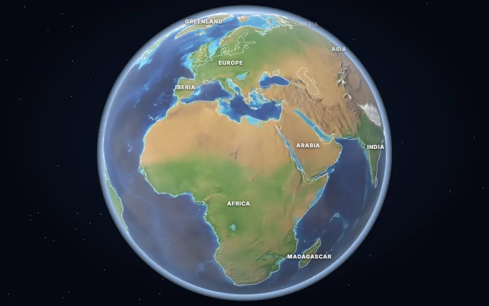 Spin it in 3D and move through time
Map: Ancient maps: PALEOMAP PaleoDEMs (Scotese & Wright 2018), CC BY 4.0 · Natural Earth.
20 million years ago, in the Early Miocene, Antarctica was covered in ice but the rest of the world was a little warmer than today. Grasslands were starting to spread, and grazing animals evolved to eat them.
Apes such as Proconsul lived in the forests of East Africa. Africa and Arabia were pushing north into Eurasia, closing the old Tethys seaway between the Mediterranean and the Indian Ocean.
The Himalaya and the Andes kept rising, changing the paths of winds and rainfall over Asia and South America.
Which land was under the sea 20 million years ago?
On the map nearest this age (20 million years ago, Early Miocene), about 4% of today’s land was under the sea at some point, some 5.8 million km². That makes it number 77 of the 80 maps from 535 to 5 million years ago, which run from 2% to 50%. Each map shows the greatest flooding of its stage, so no single moment had quite this much sea.
- Tethys Ocean
Permian to Miocene · Southern Europe, North Africa, the Middle East, Iran, the Himalaya and South-East Asia
The ocean between the northern and southern continents. As Africa, Arabia and India moved north it closed, raising the Alps and the Himalaya; the Mediterranean is what is left of it.
- Paratethys
Oligocene to Pliocene · From Vienna and the Hungarian plain to the Black Sea, the Caspian and the Aral Sea (the Aral Sea itself is a modern lake, now mostly dried)
A great inland sea north of the Alps and the Caucasus, cut off from the Tethys as the mountains rose. The Black, Caspian and Aral seas are what remain of it.
Was it under the sea? 6 of 42 cities
| Place today | 20 million years ago |
|---|---|
| Baku, Azerbaijan | Shallow sea |
| Budapest, Hungary | Shallow sea |
| Cairo, Egypt | Shallow sea |
| Nairobi, Kenya | Shallow sea |
| Rome, Italy | Shallow sea |
| Vienna, Austria | Shallow sea |
| Alice Springs, Australia | Land |
| Almaty, Kazakhstan | Land |
| Bangkok, Thailand | Land |
| Beijing, China | Land |
| Berlin, Germany | Land |
| Bismarck, United States | Land |
| Calgary, Canada | Land |
| Casper, Wyoming, United States | Land |
| Chicago, United States | Land |
| Dallas, United States | Land |
| Delhi, India | Land |
| Denver, United States | Land |
| Hannover, Germany | Land |
| Hays, Kansas, United States | Land |
| Johannesburg, South Africa | Land |
| Kansas City, United States | Land |
| Kathmandu, Nepal | Land |
| London, United Kingdom | Land |
| Madrid, Spain | Land |
| Mexico City, Mexico | Land |
| Montgomery, Alabama, United States | Land |
| Moscow, Russia | Land |
| New York, United States | Land |
| Niamey, Niger | Land |
| Novosibirsk, Russia | Land |
| Paris, France | Land |
| Perth, Australia | Land |
| Regina, Canada | Land |
| Richmond, Queensland, Australia | Land |
| Riyadh, Saudi Arabia | Land |
| Salt Lake City, United States | Land |
| São Paulo, Brazil | Land |
| Tehran, Iran | Land |
| Timbuktu, Mali | Land |
| Warsaw, Poland | Land |
| Winnipeg, Canada | Land |
3,173 marine fossil sites in the Paleobiology Database are dated closely enough to this map. Of those on today’s land, 86% fall in its shaded sea.
Seas: Ancient seas: PaleoCoastlines v7 (Kocsis & Scotese 2021), CC BY 4.0 · Fossils: Paleobiology Database.
Part of the Cenozoic Era & The Quaternary Ice Ages.